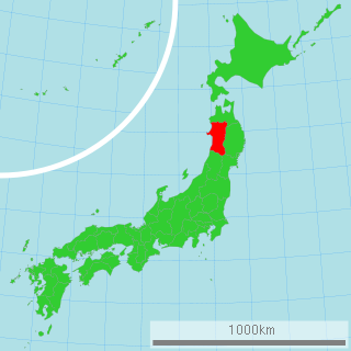
Nikaho is a city located in Akita Prefecture, Japan.

Chōkai was a town located in Yuri District, Akita Prefecture, Japan.

The Ministry of Land, Infrastructure, Transport and Tourism, abbreviated MLIT, is a ministry of the Japanese government. It is responsible for one-third of all the laws and orders in Japan, and is the largest Japanese ministry in terms of employees, as well as the second-largest executive agency of the Japanese government after the Ministry of Defense. The ministry oversees four external agencies including the Japan Coast Guard and the Japan Tourism Agency.

Yurihonjō is a city located in Akita Prefecture, Japan.

Mount Chōkai is an active volcano located on the southern border of Akita and Yamagata in the Tōhoku region of Japan, and is 2,236 m (7,336 ft) tall. Because of its (roughly) symmetrical shape and massive size, it is also known as Dewa no Fuji (出羽の富士) or by Akita natives as Akita Fuji. Mount Chōkai is regarded as sacred by followers of the Shugendō branch of Shinto and is popular with hikers.

Ōta River is a 103 kilometer-(64 mile-) long river as its main stream from Mt. Kanmuri (1,339m). The Ōta River is the major river that flows through Hiroshima Prefecture and empties into the Seto Inland Sea. The river descends through steep topography, with hydroelectric power plants situated along the river.
Mito Kaidō (水戸街道) was an old road, kaidō, in Japan and one of the five Gokaido starting from the center of Edobashi (today’s Nihonbashi. It was built to connect Edo with Mito in modern-day Ibaraki Prefecture. Travelers from Edo called it the Mito Kaidō, but travelers from Mito called it the Edo Kaidō. Today, National Route 6 follows the old Mito Kaido.
The Japan Tourism Agency, JTA, is an organization which was set up on October 1, 2008 as an agency of the Ministry of Land, Infrastructure, Transport and Tourism.

Chitose River is a river in Hokkaidō, Japan. The river is a class A river. In the city of Ebetsu, the river is sometimes known as Ebetsu River.

The Watarase River is a major river in the northern Kantō region of Japan. A tributary of the Tone River, it is 106.7 kilometres (66.3 mi) in length and drains an area of 2,621 square kilometres (1,012 sq mi). Its source is at Mount Sukai on the boundary of the city of Nikkō in Tochigi Prefecture and it empties into the Tone River at the boundary of the city of Koga in Ibaraki Prefecture and the city of Kazo in Saitama Prefecture. It is classed as a First-class river by the Japanese government.

The Geospatial Information Authority of Japan, or GSI, is the national institution responsible for surveying and mapping the national land of Japan. The former name of the organization from 1949 until March 2010 was Geographical Survey Institute. It is an organization attached to the Ministry of Land, Infrastructure, Transport and Tourism. Its main offices are situated in Tsukuba City of Ibaraki Prefecture.

The Gōnokawa River is a river that runs through Hiroshima and Shimane prefectures in Japan. It is the largest river in the Chūgoku region. It is also called the Gōgawa River and, in Hiroshima, the Enokawa River.
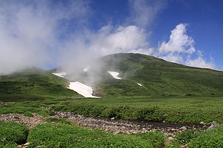
Chōkai Quasi-National Park is a Quasi-National Park in Akita and Yamagata Prefectures, Japan. Established in 1963, the park's central feature is the twin volcano of Mount Chōkai, although it also includes coastal areas of northern Yamagata and southern Akita Prefectures. It is rated a protected landscape according to the IUCN. The landscape of Kisakata (象潟), featured in Bashō's Oku no Hosomichi, was transformed by the uplift of land in an earthquake of 1804.

The Iwaki River is a river that crosses western Aomori Prefecture, Japan. It is 102 kilometers (63 mi) in length and has a drainage area of 2,544 square kilometers (982 sq mi). Under the Rivers Act of 1964 the Iwaki is designated as a Class 1 River and is managed by the Japanese Ministry of Land, Infrastructure, Transport and Tourism. The Iwaki River is the longest river in Aomori Prefecture, and is the source of irrigation for the large-scale rice and apple production of the prefecture. The Iwaki River, in the Tōhoku region north of the Fukushima Daiichi Nuclear Power Plant, remains unpolluted by radioactive materials after the Fukushima Daiichi nuclear disaster. Testing for caesium-134 and caesium-137 is carried out and published on a bimonthly basis.

The Sendai River is a river in eastern Tottori Prefecture, Japan. The Sendai is 52 kilometers (32 mi) in length and has a drainage area of 1,190 square kilometers (460 sq mi). The source of the river is in the Chūgoku Mountains. The Sendai flows north through Tottori Prefecture into the Sea of Japan. Under the Rivers Act of 1964 it is designated a Class 1 River, and is managed by the Japanese Ministry of Land, Infrastructure, Transport and Tourism. About 200,000 people live along the course of the river. The Sendai River provides sediment to form the Tottori Sand Dunes, the largest dune system in Japan.

The Yoneshiro River is a river in Tōhoku region of the northern portion of the island of Honshū in Japan. It is 136 kilometres (85 mi) long and has a watershed of 4,100 square kilometres (1,600 sq mi).
A Class A river is a river classification in Japan designated by the River Law. It is applied to rivers and waterways deemed to be important to the economy of the nation as a whole, as well as those deemed important to the conservation of nature within Japan. There are currently 109 rivers with this designation.

Kuji River is a river in Fukushima Prefecture, Tochigi Prefecture and Ibaraki Prefecture, Japan. It rises at the northern slope of Mount Yamizo, where the border of these three prefectures is located, and flows into Pacific Ocean at Hitachi and Tokai in Ibaraki Prefecture. It has a length of 124 kilometers (77 mi) and a drainage area of 1,490 square kilometers (580 sq mi), and is designated as a Class A river.
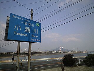
The Oze River is a river in Hiroshima Prefecture and Yamaguchi Prefecture, Japan. The river forms part of the border between the two prefectures, which used to be the border between former Suō Province and Aki Province. It is also known as Kono River (木野川).