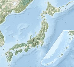
Hiroshima Prefecture is a prefecture of Japan located in the Chūgoku region of Honshu. Hiroshima Prefecture has a population of 2,811,410 and has a geographic area of 8,479 km². Hiroshima Prefecture borders Okayama Prefecture to the east, Tottori Prefecture to the northeast, Shimane Prefecture to the north, and Yamaguchi Prefecture to the southwest.
Miyoshi is a city located in Hiroshima Prefecture, Japan. As of 31 March 2023, the city had an estimated population of 49,106 in 23154 households and a population density of 63 persons per km². The total area of the city is 778.14 square kilometres (300.44 sq mi).

Bingo Province was a province of Japan on the Inland Sea side of western Honshū, comprising what is today the eastern part of Hiroshima Prefecture. It was sometimes grouped together with Bizen and Bitchu Provinces as Bishū (備州). The 備 bi in the names of these provinces is taken from the second character in the name of Kibi Province, whose ambit also included the area that would be divided off as Mimasaka Province in the early 8th century CE. Bingo bordered Bitchū, Hōki, Izumo, Iwami, and Aki Provinces.
The Jinzū River is a river that flows from Gifu Prefecture to Toyama Prefecture in Japan. The upper reaches of the river in Gifu are called the Miya River. It is 120 km (75 mi) in length and has a watershed of 2,720 square kilometres (1,050 sq mi).

The Arakawa River or Ara River is a 173-kilometre (107 mi) long river that flows through Saitama Prefecture and Tokyo. Its average flow in 2002 was 30m³/s.

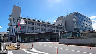
Fukuyama is a city in Hiroshima Prefecture, Japan. As of 31 March 2023, the city had an estimated population of 459,160 in 214259 households and a population density of 890 persons per km². The total area of the city is 518.14 square kilometres (200.05 sq mi). After Hiroshima, it is the largest city in Hiroshima Prefecture. The city's symbol is the rose and it holds an annual Rose Festival in the month of May. The official mascot of Fukuyama is an anthropomorphic rose child by the name of Rola.

The Takahashi River is a Class A major river in the western part of Okayama Prefecture. It acts as the main drainage for the Takahashi River Drainage System, and is one of the three main drainage rivers in Okayama Prefecture.

Chūgoku Mountains is a mountain range in the Chūgoku region of western Japan. It runs in an east–west direction and stretches approximately 500 km (311 mi) from Hyōgo Prefecture in the east to the coast of Yamaguchi Prefecture. The range also reaches under the Pacific Ocean.

Mihara Castle was a hirajiro-style Japanese castle located in what is today the city of Mihara in Hiroshima Prefecture. Its ruins have been protected by the central government as a National Historic Site since 1957.

The Gōnokawa River is a river that runs through Hiroshima and Shimane prefectures in Japan. It is the largest river in the Chūgoku region. It is also called the Gōgawa River and, in Hiroshima, the Enokawa River.

Mana Ashida is a Japanese actress, talent and singer. Her first appearance was in Asahi Broadcasting Corporation's ABC Short Movie 2, though she rose to prominence after acting in the television drama Mother. She became the youngest lead star in Japanese drama history when she starred in Sayonara Bokutachi no Youchien. She was the youngest lead actress in a television serial drama by appearing in the serial drama Marumo no Okite in the spring of 2011. She also appeared in Japanese films such as Confessions and Bunny Drop.

The Zenibako River (銭函川) runs from Otaru, Hokkaidō, Hokkaidō, Japan and ends in the Sea of Japan. It is a Normal Class River of the Zenibako River System under Japanese River Law.
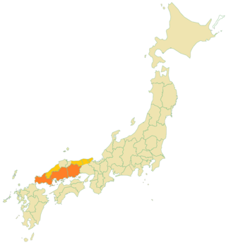
The Chūgoku dialect is a group of the Japanese dialects spoken in most of the Chūgoku region and in the northwestern Kansai region. It may be separated into two groups according to the form of the copula.

The Mihara Domain was a feudal domain of Japan in the Edo period. Located in what is now Mihara City, Hiroshima Prefecture, it encompassed the southern part of Bingo Province. Its headquarter was Mihara Castle. At its peak, it was rated at 30,000 koku. For more than two hundred years the daimyō of Mihara were a collateral branch of the Asano clan who held Hiroshima Domain. It was a subordinate of Hiroshima Domain where the main line of the Asano clan ruled from.

Kuji River is a river in Fukushima Prefecture, Tochigi Prefecture and Ibaraki Prefecture, Japan. It rises at the northern slope of Mount Yamizo, where the border of these three prefectures is located, and flows into Pacific Ocean at Hitachi and Tokai in Ibaraki Prefecture. It has a length of 124 kilometers (77 mi) and a drainage area of 1,490 square kilometers (580 sq mi), and is designated as a Class A river.

The Kita River is a river in Shiga and Fukui Prefectures, Japan. It is designated a Class A river by the Ministry of Land, Infrastructure, Transport and Tourism (MLIT). It empties into Obama Bay, a sub-bay of Wakasa Bay on the Sea of Japan about 280 metres (920 ft) northeast of the mouth of the Minami River. It has been ranked among the best rivers in Japan for water quality since 1981.

The Hii River is a river on the island of Honshu in Shimane Prefecture and Tottori Prefecture, Japan. With a length of 153 km and catchment of 2540 km2, it is the largest river in the east of Shimane Prefecture. It flows through the cities of Izumo and Matsue and through the lakes Shinji and Nakaumi and discharges into the Sea of Japan.

Kuji River is a river in Kuji, Iwate of Japan. It rises at Mount Myojindake located in Kitakami Mountains, and flows into the Pacific Ocean at Kuji City. It is 27.609 kilometers (17.155 mi) in length, and is designated as a Class B river. The urban area of Kuji City is situated on the alluvial plain of the river.

The Bingo dialect is a Japanese dialect spoken in the Bingo Region of eastern Hiroshima Prefecture. It is part of the Chūgoku dialect group.