
Fukushima is the capital city of Fukushima Prefecture, Japan. It is located in the northern part of the Nakadōri, central region of the prefecture. As of 1 August 2023, the city had an estimated population of 275,850 in 122,130 households and a population density of 359 inhabitants per square kilometre (930/sq mi). The total area of the city is 767.72 square kilometres (296.42 sq mi).
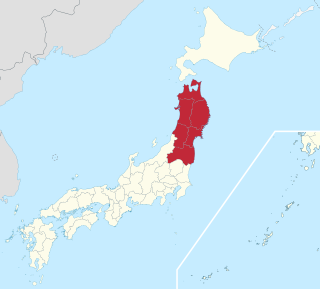
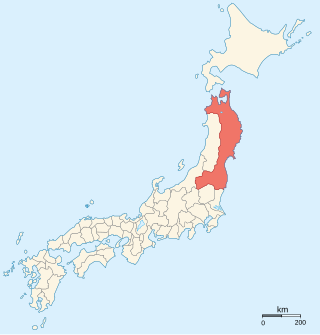
The Tōhoku region, Northeast region, Ōu region, or Northeast Japan consists of the northeastern portion of Honshu, the largest island of Japan. This traditional region consists of six prefectures (ken): Akita, Aomori, Fukushima, Iwate, Miyagi, and Yamagata.

Natori is a city located in Miyagi Prefecture, Japan. As of 31 May 2020, the city had an estimated population of 79,459 in 31,748 households, and a population density of 810 persons per km². The total area of the city is 98.17 square kilometres (37.90 sq mi).
Shiroishi is a city in Miyagi Prefecture, Japan. As of 31 May 2020, the city had an estimated population of 33,330 and a population density of 120 persons per km2 in 14,242 households. The total area of the city is 286.48 square kilometres (110.61 sq mi).

Sendai is the capital city of Miyagi Prefecture, the largest city in the Tōhoku region. As of 1 August 2023, the city had a population of 1,098,335 in 539,698 households, and is one of Japan's 20 designated cities. The city was founded in 1600 by the daimyō Date Masamune. It is nicknamed the City of Trees; there are Japanese zelkova trees lining many of the main thoroughfares such as Jōzenji Street and Aoba Street. In the summer, the Sendai Tanabata Festival, the largest Tanabata festival in Japan, is held. In winter, the trees are decorated with thousands of lights for the Pageant of Starlight, lasting through most of December. The city is also home to Tohoku University, consistently ranked amongst the top institutions of higher education in Japan. On 11 March 2011, coastal areas of the city suffered catastrophic damage from a magnitude 9.0 offshore earthquake, which triggered a destructive tsunami.
Mutsu Province was an old province of Japan in the area of Fukushima, Miyagi, Iwate and Aomori Prefectures and the municipalities of Kazuno and Kosaka in Akita Prefecture.
Shichikashuku is a town located in Katta District, Miyagi Prefecture, Japan. As of 1 June 2020, the town had an estimated population of 1,323, and a population density of 5.0 persons per km² in 626 households. The total area of the town is 263.09 square kilometres (101.58 sq mi).

Murata is a town located in Miyagi Prefecture, Japan. As of 31 May 2020, the town had an estimated population of 10,675, and a population density of 140 persons per km2 in 4026 households. The total area of the town is 78.38 square kilometres (30.26 sq mi). In September 2014, the 7.4 hectare old centre of town was protected as an Important Preservation District by the national government for its traditional merchant quarter architecture.
Miyagi District is a district located in former Mutsu Province and today's Miyagi Prefecture, Japan. The name of the prefecture was from this district.
National Route 4 is a major national highway in eastern Honshū, Japan. Measuring 738.5 kilometers long (458.9 mi), it is the longest highway in the country. When oversea routes are included, it is the second longest highway in Japan, with National Route 58 then measuring 884.4 kilometers (549.5 mi) because of its maritime sections. The highway connects Tokyo and Aomori via Utsunomiya, Kōriyama, Sendai, and Morioka.

Taihaku-ku (太白区) is the southernmost ward of the city Sendai, in Miyagi Prefecture, Japan. As of 1 March 2023, the ward had a population of 234,391 and a population density of 1028 persons per km2 in 113,068 households. The total area of the ward was 228.39 square kilometres (88.18 sq mi). Taihaku-ku is eleventh largest ward in Japan in terms of area, and second-largest in Sendai. The western portion of the ward is the former town of Akiu, Miyagi.

Wakabayashi-ku (若林区) is the eastern ward of the city Sendai, in Miyagi Prefecture, Japan. As of 1 June 2019, the ward had a population of 138,102 and a population density of 2715 persons per km² in 63583 households. The total area of the ward was 50.86 square kilometres (19.64 sq mi).

Taishidō Station is a junction railway station in Taihaku-ku, Sendai, Miyagi Prefecture, Japan, operated by East Japan Railway Company.

Hanayama Dam is a dam on the Hasama River, belonging to the Kitakami Class A river system, in Kurihara, Miyagi Prefecture, Japan, completed in 1957.
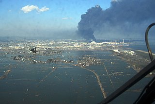
On 11 March 2011, at 14:46 JST, a 9.0–9.1 undersea megathrust earthquake occurred in the Pacific Ocean, 72 km (45 mi) east of the Oshika Peninsula of the Tōhoku region. It lasted approximately six minutes, causing a tsunami. It is sometimes known in Japan as the "Great East Japan Earthquake", among other names. The disaster is often referred to by its numerical date, 3.11.

Akiu Great Falls is a waterfall located in Taihaku-ku, Sendai, Miyagi Prefecture, Japan. It is a nationally designated Place of Scenic Beauty. It is one of "Japan’s Top 100 Waterfalls", in a listing published by the Japanese Ministry of the Environment in 1990.

Miyagi Prefecture is a prefecture of Japan located in the Tōhoku region of Honshu. Miyagi Prefecture has a population of 2,265,724 and has a geographic area of 7,282 km2 (2,812 sq mi). Miyagi Prefecture borders Iwate Prefecture to the north, Akita Prefecture to the northwest, Yamagata Prefecture to the west, and Fukushima Prefecture to the south.

The Mabechi River is a river located in northern Iwate Prefecture and eastern Aomori Prefecture, in the Tōhoku region of northern Honshū in Japan.
The Michinoku Coastal Trail (みちのく潮風トレイル) is one of the ten Long Distance Nature Trails of Japan. It is located on the eastern coast of Tohoku.
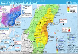
On March 16, 2022, at 23:36 JST, a strong earthquake struck off the coast of Fukushima, Japan. The earthquake had a magnitude of 7.4 according to the Japanese Meteorological Agency (JMA), while the United States Geological Survey (USGS) gave an estimate of 7.3. Immediately after the event a 30‑cm tsunami was reported. The event is known in Japanese as Fukushima-ken Oki Jishin. As a result of this natural disaster, four people died and 247 were injured.


