
The Sakai River is a Class B river in Tokyo and Kanagawa Prefecture which flows into the Bay of Sagami of the Pacific Ocean.

The Liaodong or Liaotung Peninsula is a peninsula in southern Liaoning province in Northeast China, and makes up the southwestern coastal half of the Liaodong region. It is located between the mouths of the Daliao River in the west and the Yalu River in the east, and encompasses the territories of the whole sub-provincial city of Dalian and parts of prefectural cities of Yingkou, Anshan and Dandong.
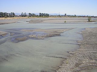
The Abe River is a Class A river in Shizuoka Prefecture of central Japan. It is 53.3 kilometres (33.1 mi) long and has a watershed of 567 square kilometres (219 sq mi). Approximately 170,000 people live in the basin area.
Kita District is a district located in Kagawa Prefecture, Japan.

The Yodo River, also called the Seta River and the Uji River at portions of its route, is the principal river in Osaka Prefecture on Honshu, Japan. The source of the river is Lake Biwa in Shiga Prefecture to the north.
The Ōi River is a river in Shizuoka Prefecture, Japan.

The Kamo River is located in Kyoto Prefecture, Japan. The riverbanks are popular walking spots for residents and tourists. In summer, restaurants open balconies looking out to the river. There are walkways running alongside the river, and some stepping stones that cross the river. The water level of the river is usually relatively low; less than one meter in most places. During the rainy season, however, the walkways sometimes flood in their lower stretches.

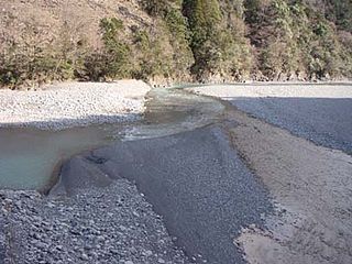
The Tenryū River is a river in central Honshū, Japan. With a length of 213 km (132 mi), it is Japan's ninth longest river.

The Kitakami River is the fourth largest river in Japan and the largest in the Tōhoku region. It is 249 kilometres (155 mi) long and drains an area of 10,150 square kilometres (3,920 sq mi). It flows through mostly rural areas of Iwate and Miyagi Prefectures. The source of the river is the Mount Nanashigure in northern Iwate, from which it flows to the south between the Kitakami Mountains and the Ōu Mountains. The river is unusual in that it has two mouths, one flowing south into Ishinomaki Bay and the other flowing east into the Pacific Ocean, both in Ishinomaki City.

The Yahagi River is a river that flows from Nagano Prefecture's Mount Ōkawairi, through Gifu Prefecture, and enters Mikawa Bay from Aichi Prefecture in Japan. It is designated an A class river by the Ministry of Land, Infrastructure, Transport and Tourism (MLIT).

Shag Point / Matakaea is a headland and township in East Otago, New Zealand. Both the point and the nearby Shag River take their English name from a seabird, the pied shag.
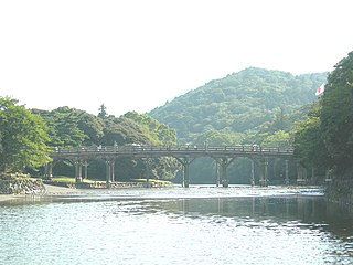
The Isuzu River is a river that has both its source and its mouth in the city of Ise, Mie Prefecture, Japan. The river is notable because it flows through Ise Grand Shrine and, due to its strong association with the Shrine, many songs and poems have been written about it throughout history. The Uji Bridge serves as the entrance to Ise Grand Shrine, and crosses the Isuzu River. Isuzu Motors company is named after the river.

The Seta River is a river that has both its source and its mouth in the city of Ise, Mie Prefecture, Japan. It flows through the heart of Ise. In 1980, it was designated the most polluted river in Mie, however it no longer holds this status due to cleanup efforts by the city of Ise.

Sōgo Station is a railway station in Bizen, Okayama Prefecture, Japan.
The Narraguagus River is a river located in the U.S. state of Maine with its mouth in the Narraguagus Bay of the Gulf of Maine. It flows through the town of Cherryfield and was formerly well known for its sport fly fishing for Atlantic salmon. This was a traditional highlight of late spring with anglers gathering from afar for the Memorial Day weekend fishing kick-off. The native salmon run has been much reduced due to many different factors.

The Suketō River, also called the Fukushima River, is a river in Tokushima Prefecture, Japan.
Konohana-ku (此花区) is one of 24 wards of Osaka city, Japan. It stands at the mouth of the Yodo River. It is home to the popular western-style theme park of Universal Studios Japan. It will be the site of Expo 2025, a World's Fair to be held in 2025.

Shikoku Saburo Bridge is a bridge in Tokushima Prefecture, Shikoku that spans the Yoshino River. It joins Ojin-cho on the north of the river to Fudouhigashi-cho on the south of the river. The Bridge is 910.5 metres in length and 14 metres in width, with a two-lane highway running atop. The bridge was opened to the public in 1998.

Kakogawa Steel Works is Kobe Steel, Ltd.'s ironworks in Kakogawa, Hyogo, Japan, established in 1969. It is responsible for about 80 percent of the company's iron and steel production.
Zephyrium or Zephyrion, also called Zephyrium on the Calycadnus to differentiate it from other towns called Zephyrium, was a town of ancient Cilicia on the Calycadnus River near its mouth, on a promontory of the same name.

