List of capitals in Japan

Last updated

A prefectural capital is a city where a prefectural government and assembly is located.

Contents

Japan

In Japan, a prefectural capital is officially called todōfukenchō shozaichi ( 都道府県庁所在地 , "seat of a prefectural government", singular: 都庁所在地,tochō shozaichi in the [Tōkyō]-to, 道庁所在地, dōchō shozaichi in the [Hokkai]-dō, 府庁所在地, fuchō shozaichi in -fu, 県庁所在地, kenchō shozaichi in -ken), but the term kento ( 県都 , "prefectural capital") is also used (dōto ( 道都 , in the -dō, but never "futo" or "toto")).

List of Japanese prefectural capitals

Capital Prefecture Regions and Prefectures of Japan 2.svg
Region
Island Pop.¹ ISO Status
Flag of Akita, Akita.svg Akita Flag of Akita Prefecture.svg  Akita Tōhoku Honshū 327,651JP-05 Core city
Flag of Aomori, Aomori.svg Aomori Flag of Aomori Prefecture.svg  Aomori Tōhoku Honshū 304,657JP-02Core city
Flag of Chiba, Chiba.svg Chiba Flag of Chiba.svg  Chiba Kantō Honshū 943,568JP-12 Designated city
Flag of Fukui, Fukui.svg Fukui Flag of Fukui Prefecture.svg  Fukui Chūbu Honshū 268,210JP-18Core city
Flag of Fukuoka City.svg Fukuoka Flag of Fukuoka Prefecture.svg  Fukuoka Kyūshū Kyūshū 1,434,650JP-40Designated city
Flag of Fukushima, Fukushima.svg Fukushima Flag of Fukushima.svg  Fukushima Tōhoku Honshū 288,602JP-07Core city
Flag of Gifu, Gifu.svg Gifu Flag of Gifu Prefecture.svg  Gifu Chūbu Honshū 411,753JP-21Core city
Flag of Hiroshima City.svg Hiroshima Flag of Hiroshima Prefecture.svg  Hiroshima Chūgoku Honshū 1,164,885JP-34Designated city
Flag of Kagoshima, Kagoshima.svg Kagoshima Flag of Kagoshima Prefecture.svg  Kagoshima Kyūshū Kyūshū 604,268JP-46Core city
Flag of Kanazawa, Ishikawa.svg Kanazawa Flag of Ishikawa.svg  Ishikawa Chūbu Honshū 455,952JP-17Core city
Flag of Kobe.svg Kobe Flag of Hyogo.svg  Hyōgo Kansai Honshū 1,532,305JP-28Designated city
Flag of Kochi, Kochi.svg Kōchi Flag of Kochi.svg  Kōchi Shikoku Shikoku 345,418JP-39Core city
Flag of Kofu, Yamanashi.svg Kōfu Flag of Yamanashi Prefecture.svg  Yamanashi Chūbu Honshū 198,757JP-19Core city
Flag of Kumamoto, Kumamoto.svg Kumamoto Flag of Kumamoto.svg  Kumamoto Kyūshū Kyūshū 670,014JP-43Designated city
Flag of Kyoto City.svg Kyoto Flag of Kyoto Prefecture.svg  Kyōto Kansai Honshū 1,468,065JP-26Designated city
Flag of Maebashi, Gunma.svg Maebashi Flag of Gunma Prefecture.svg  Gunma Kantō Honshū 317,167JP-10Core city
Flag of Matsue, Shimane.svg Matsue Flag of Shimane.svg  Shimane Chūgoku Honshū 195,008JP-32Core city
Flag of Matsuyama, Ehime.svg Matsuyama Flag of Ehime Prefecture.svg  Ehime Shikoku Shikoku 514,771JP-38Core city
Flag of Mito, Ibaraki.svg Mito Flag of Ibaraki.svg  Ibaraki Kantō Honshū 263,299JP-08Core city
Flag of Miyazaki, Miyazaki.svg Miyazaki Flag of Miyazaki Prefecture.svg  Miyazaki Kyūshū Kyūshū 368,984JP-45Core city
Flag of Morioka, Iwate.svg Morioka Flag of Iwate.svg  Iwate Tōhoku Honshū 298,959JP-03Core city
Flag of Nagano, Nagano.svg Nagano Flag of Nagano Prefecture.svg  Nagano Chūbu Honshū 377,328JP-20Core city
Flag of Nagasaki, Nagasaki.svg Nagasaki Flag of Nagasaki Prefecture.svg  Nagasaki Kyūshū Kyūshū 446,551JP-42Core city
Flag of Nagoya, Aichi.svg Nagoya Flag of Aichi Prefecture.svg  Aichi Chūbu Honshū 2,243,564JP-23Designated city
Flag of Naha, Okinawa.svg Naha Flag of Okinawa Prefecture.svg  Okinawa Kyūshū Ryūkyū Islands 313,436JP-47Core city
Flag of Nara, Nara.svg Nara Flag of Nara Prefecture.svg  Nara Kansai Honshū 366,863JP-29Core city
Flag of Niigata, Niigata.svg Niigata Flag of Niigata Prefecture.svg  Niigata Chūbu Honshū 811,613JP-15Designated city
Flag of Oita, Oita.svg Ōita Flag of Oita Prefecture.svg  Ōita Kyūshū Kyūshū 467,617JP-44Core city
Flag of Okayama, Okayama.svg Okayama Flag of Okayama Prefecture.svg  Okayama Chūgoku Honshū 700,646JP-33Designated city
Flag of Osaka City.svg Osaka Flag of Osaka.svg  Ōsaka Kansai Honshū 2,649,601JP-27Designated city
Flag of Otsu, Shiga.svg Ōtsu Flag of Shiga Prefecture.svg  Shiga Kansai Honshū 330,044JP-25Core city
Flag of Saga, Saga.svg Saga Flag of Saga Prefecture.svg  Saga Kyūshū Kyūshū 239,003JP-41 Special city
Flag of Saitama, Saitama.svg Saitama Flag of Saitama.svg  Saitama Kantō Honshū 1,197,471JP-11Designated city
Flag of Sapporo, Hokkaido.svg Sapporo Flag of Hokkaido Prefecture.svg  Hokkaidō Hokkaidō Hokkaidō 1,896,704JP-01Designated city
Flag of Sendai, Miyagi.svg Sendai Flag of Miyagi Prefecture.svg  Miyagi Tōhoku Honshū 1,029,576JP-04Designated city
Flag of Shinjuku, Tokyo.svg Shinjuku [1] Flag of Tokyo Metropolis.svg  Tōkyō Kantō Honshū 314,262JP-13 Special wards
Flag of Shizuoka, Shizuoka.svg Shizuoka Flag of Shizuoka Prefecture.svg  Shizuoka Chūbu Honshū 709,888JP-22Designated city
Flag of Takamatsu, Kagawa.svg Takamatsu Flag of Kagawa Prefecture.svg  Kagawa Shikoku Shikoku 417,671JP-37Core city
Flag of Tokushima, Tokushima.svg Tokushima Flag of Tokushima.svg  Tokushima Shikoku Shikoku 265,248JP-36 City
Flag of Tottori, Tottori.svg Tottori Flag of Tottori Prefecture.svg  Tottori Chūgoku Honshū 199,319JP-31Core city
Flag of Toyama, Toyama.svg Toyama Flag of Toyama Prefecture.svg  Toyama Chūbu Honshū 420,584JP-16Core city
Flag of Tsu, Mie.svg Tsu Flag of Mie prefecture.svg  Mie Kansai Honshū 287,849JP-24City
Flag of Utsunomiya, Tochigi.svg Utsunomiya Flag of Tochigi.svg  Tochigi Kantō Honshū 508,114JP-09Core city
Flag of Wakayama, Wakayama.svg Wakayama Flag of Wakayama Prefecture.svg  Wakayama Kansai Honshū 371,504JP-30Core city
Flag of Yamagata, Yamagata.svg Yamagata Flag of Yamagata Prefecture.svg  Yamagata Tōhoku Honshū 254,724JP-06Core city
Flag of Yamaguchi, Yamaguchi.svg Yamaguchi Flag of Yamaguchi Prefecture.svg  Yamaguchi Chūgoku Honshū 191,714JP-35City
Flag of Yokohama, Kanagawa.svg Yokohama Flag of Kanagawa.svg  Kanagawa Kantō Honshū 3,643,641JP-14Designated city

Notes: ¹ as of 1 May 2008

Non-capitals which share a name with their prefecture

In most cases, a city that share a name with its prefecture is a prefectural capital. However, there are some municipalities that are not capitals.

Capitals that are not the largest city/metropolitan area in their prefecture

Those in italics are prefectural capitals, or metropolitan areas of them.

Flag of Fukushima.svg  Fukushima Prefecture
1. Flag of Iwaki, Fukushima.svg Iwaki 348,322 1.Kōriyama Metropolitan Area537,493
2. Flag of Koriyama, Fukushima.svg Kōriyama 338,887 2.Fukushima Metropolitan Area412,353
3. Flag of Fukushima, Fukushima.svg Fukushima 294,724 3.Iwaki Metropolitan Area365,864
Flag of Gunma Prefecture.svg  Gunma Prefecture
1. Flag of Takasaki, Gunma.svg Takasaki 342,662 1.Takasaki Metropolitan Area532,271
2. Flag of Maebashi, Gunma.svg Maebashi 317,114 2.Maebashi Metropolitan Area458,996
Flag of Mie prefecture.svg  Mie Prefecture
1. Flag of Yokkaichi, Mie.svg Yokkaichi 307,418 1.Yokkaichi Metropolitan Area606,071
2. Flag of Tsu, Mie.svg Tsu 288,874 2.Tsu Metropolitan Area308,375
Flag of Shizuoka Prefecture.svg  Shizuoka Prefecture
1. Flag of Hamamatsu, Shizuoka.svg Hamamatsu 812,692 1.Shizuoka Metropolitan Area999,360
2. Flag of Shizuoka, Shizuoka.svg Shizuoka 709,772 2.Hamamatsu Metropolitan Area919,933
Flag of Tottori Prefecture.svg  Tottori Prefecture
1. Flag of Tottori, Tottori.svg Tottori 199,263 1.Yonago Metropolitan Area252,387
2. Flag of Yonago, Tottori.svg Yonago 148,234 2.Tottori Metropolitan Area249,067
Flag of Yamaguchi Prefecture.svg  Yamaguchi Prefecture
1. Flag of Shimonoseki, Yamaguchi.svg Shimonoseki 284,693 1.Shimonoseki Metropolitan Area287,935
2. Flag of Yamaguchi, Yamaguchi.svg Yamaguchi 191,740 2.Ube Metropolitan Area258,180
3. Flag of Ube, Yamaguchi.svg Ube 175,334 3.Yamaguchi Metropolitan Area178,402

Notes:

City populations are as of July 2008.
Metropolitan area populations are as of 2000. (Urban Employment Areas)

Related Research Articles

A prefecture is an administrative jurisdiction traditionally governed by an appointed prefect. This can be a regional or local government subdivision in various countries, or a subdivision in certain international church structures, as well as in antiquity a Roman district.

Prefectures of Japan Overview of the prefectures of Japan

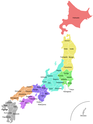
Japan is divided into 47 prefectures, which rank immediately below the national government and form the country's first level of jurisdiction and administrative division. They include 43 prefectures proper, two urban prefectures, one "circuit" or "territory" and one metropolis. In 1868, the Meiji Fuhanken sanchisei administration created the first prefectures to replace the urban and rural administrators in the parts of the country previously controlled directly by the shogunate and a few territories of rebels/shogunate loyalists who had not submitted to the new government such as Aizu/Wakamatsu. In 1871, all remaining feudal domains (han) were also transformed into prefectures, so that prefectures subdivided the whole country. In several waves of territorial consolidation, today's 47 prefectures were formed by the turn of the century. In many instances, these are contiguous with the ancient ritsuryō provinces of Japan.

Saitama Prefecture Prefecture of Japan

Saitama Prefecture is a landlocked prefecture of Japan located in the Kantō region of Honshu. Saitama Prefecture has a population of 7,338,536 and has a geographic area of 3,797 km². Saitama Prefecture borders Tochigi Prefecture and Gunma Prefecture to the north, Nagano Prefecture to the west, Yamanashi Prefecture to the southwest, Tokyo to the south, Chiba Prefecture to the southeast, and Ibaraki Prefecture to the northeast.

Kantō region Region of Japan

The Kanto region is a geographical area of Honshu, the largest island of Japan. In a common definition, the region includes the Greater Tokyo Area and encompasses seven prefectures: Gunma, Tochigi, Ibaraki, Saitama, Tokyo, Chiba and Kanagawa. Within its boundaries, slightly more than 45 percent of the land area is the Kanto Plain. The rest consists of the hills and mountains that form the land borders. According to the official census on October 1, 2010, by the Japan Statistics Bureau, the population was 42,607,376, amounting to approximately one third of the total population of Japan.

Cities of Japan Overview of local administrative units in Japan

A city is a local administrative unit in Japan. Cities are ranked on the same level as towns and villages, with the difference that they are not a component of districts. Like other contemporary administrative units ,they are defined by the Local Autonomy Law of 1947.

Mooka, Tochigi City in Kantō, Japan

Mooka is a city located in Tochigi Prefecture, Japan. As of 1 August 2020, the city had an estimated population of 78,720 in 30203 households, and a population density of 476 persons per km². The total area of the city is 167.34 square kilometres (64.61 sq mi). Moka is known for the Mooka Railway, which operates steam locomotives. The train line stretches from Shimodate, Ibaraki Prefecture to Motegi, Tochigi Prefecture. The town produces 7,000 tons of strawberries annually. The name of the city is given as "Moka City" per the city's official website; however, the local train station is "Mōka Station", and the direct transliteration of the city name into Hepburn romanization is "Mooka".

Greater Tokyo Area Place in Japan

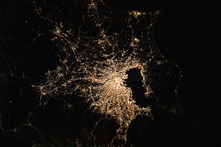
The Greater Tokyo Area is the most populous metropolitan area in the world, consisting of the Kantō region of Japan as well as the prefecture of Yamanashi of the neighboring Chūbu region. In Japanese, it is referred to by various terms, one of the most common being Capital Region.

Japanese place names include names for geographic features, present and former administrative divisions, transportation facilities such as railroad stations, and historic sites in Japan. The article Japanese addressing system contains related information on postal addresses.

The bureaucratic administration of Japan is divided into three basic levels; national, prefectural, and municipal. Below the national government there are 47 prefectures, six of which are further subdivided into subprefectures to better service large geographical areas or remote islands. The municipalities are the lowest level of government; the twenty most-populated cities outside Tokyo Metropolis are known as designated cities and are subdivided into wards.

Prefectural roads in Japan are roads usually planned, numbered and maintained by the government of the respective prefecture, independent of other prefectures – as opposed to national roads (kokudō), which in legal terms include national expressways, and municipal roads ([ku]shichōsondō). Where a national or prefectural road runs through the territory of a designated major city, the city government assumes part of the responsibility for these roads. By length, 10.7 % of public roads in Japan were prefectural roads as of 2011; by usage, they carried more than 30% of all traffic volume on public roads as of 2007.

"Rock 'n' Roll Kenchōshozaichi" is a rockabilly song by Japanese singer/songwriter Chisato Moritaka, from her 1992 studio album Pepperland. Written by Moritaka, the song was released as the B-side of her 1993 single "Watashi no Natsu".

National Route 282 is a national highway of Japan connecting the cities of Morioka, the capital city of Iwate Prefecture, and Hirakawa in southern Aomori Prefecture. It travels south to north and has a total length of 124.4 kilometers (77.3 mi).

Prefectural police department

In the law enforcement system in Japan, Prefectural Police are responsible for the regular police affairs as to the areas of the respective prefectures. Although these Prefectural Polices are in principle regarded as municipal police, they are, in fact, in many parts under the central oversight and control of the National Police Agency. As of 2017, the total strength of the prefectural police is approximately 288,000: 260,400 sworn officers and 28,400 civilian staff.

References

  1. 都庁の所在地 Archived 2014-04-19 at the Wayback Machine Shinjuku is the location of the Tokyo Metropolitan Government Building, Tokyo not having itself been a "municipality" since 1943.