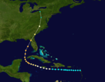
The 1896 Atlantic hurricane season was fairly inactive but produced one of the costliest hurricanes ever to strike the United States until that point, along with several other destructive tropical cyclones. The season began in early July with a hurricane in the Gulf of Mexico and ended in late November with a slow-moving tropical storm over the Lesser Antilles. Of the season's seven documented systems, six are believed to have become hurricanes, and two intensified into major hurricanes—the equivalence of Category 3 or greater on the modern-day Saffir–Simpson scale. All but one of the systems directly affected land to some degree; Hurricane "Six" remained over open water and only posed a threat to shipping lanes. In addition, a possible storm was identified off the coast of North Carolina on August 28–29, but modern reanalysis efforts have found insufficient evidence to classify it as a tropical cyclone.[1] Tropical systems in the 1896 season killed at least 286 people and inflicted more than $10 million (1896 USD) in damage.
The first hurricane made landfall in the Florida Panhandle on July 7, causing wind damage and coastal flooding in Pensacola, and destroying boats at port. No activity was observed until late August when a hurricane triggered widespread river flooding in Puerto Rico. After moving north, this storm struck eastern New England. Hurricane "Three" avoided land, but its outer periphery generated gusty winds in the Outer Banks of North Carolina. On September 29, fast-moving Hurricane "Four" became one of the costliest United States hurricanes on record at the time after swamping Florida's Cedar Keys with a large storm surge and subsequently causing extensive devastation in the eastern United States. The hurricane caused 202 deaths and more than $9 million in damage across eight states, plus Washington, D.C., and the Great Lakes. About two weeks later, Hurricane "Five" roughly paralleled the U.S. East Coast, causing substantial coastal flooding and destruction of beachfront property. Little is known about the season's sixth hurricane which never affected land. Torrential rainfall associated with the final tropical storm of the season triggered deadly flooding on Montserrat, where nearly 50 people drowned and many more lost their homes.
Timeline
Systems
Hurricane One
Category 2hurricane(SSHWS)
Duration
July 4– July 9
Peak intensity
100mph (155km/h) (1-min);
The first documented tropical cyclone of the 1896 season has unclear origins. Although its official track in the National Hurricane Center's Atlantic hurricane database shows a northwestward path over Cuba,[2] contemporary United States Weather Bureau maps indicated formation in the western Gulf of Mexico,[3] and news reports discussed an eastward motion of the storm. Additionally, no severe weather was observed in Cuba during the month of July.[1] In any event, the storm likely intensified into a hurricane on July 5, and around midday on July 7, it made landfall on the Florida Panhandle east of Pensacola, at Category 2 intensity.[2] Upon moving ashore, the hurricane produced powerful winds as high as 100mph (160km/h).[1] The storm rapidly weakened as it moved inland, and after tracking north for five days, its remnants dissipated near Baffin Bay on July 12.[2]
Widespread damage was reported in Pensacola and along the coast, with watercraft suffering the greatest losses. In the city's harbor, the storm sank nine fishing boats, damaged two barques and a brig, and wrecked numerous smaller vessels. The winds damaged chimneys, signs, awnings, overhead wires, and some buildings throughout the city. About 35 house were unroofed,[4] along with several stores, a hotel, and a church. Fallen trees rendered streets impassable,[5] and railroads near the shore were washed out.[6] Total damage in the city was estimated at $100,000.[4] As the storm moved inland, gusty winds and heavy rainfall extended into parts of Alabama, Georgia, the Carolinas, and southern Virginia.[1] Precipitation peaked at 12.0 inches (300mm) in Greenwood, South Carolina.[7] On the morning of July 8, rainbands on the storm's eastern side spawned a tornado in Halifax County, North Carolina, that killed one person and destroyed several houses. Several more tornadoes developed in Virginia later in the day, causing five injuries and scattered damage.[4][8]
On August 30, a tropical storm materialized east of the Lesser Antilles, on a northwestward course.[9] The next night, it made landfall on the southern coast of Puerto Rico as a Category 2 hurricane, accompanied by severe rain and wind.[1][10] The storm passed just north of Hispaniola and Cuba over the next several days,[1] delivering tropical storm-force winds to the islands.[10] On the evening of September 6, while near the Bahamas, a steamship crossed the center of the hurricane and recorded a barometric pressure of 28.24inHg (956mbar).[11] This corresponds to maximum sustained winds of 115mph (185km/h), or a Category 3 major hurricane, which represents storm's peak intensity.[10] The ship suffered extensive damage and lost one crew member when he fell overboard.[1] Tracking generally northward, the storm weakened to minimal hurricane intensity before making landfall over eastern Massachusetts on September 10, with 80mph (130km/h) maximum sustained winds extending to a radius of 35mi (55km) from the center.[2][10] Sustained hurricane-force winds were observed in both Rhode Island and Massachusetts as the storm moved ashore.[12] The system transitioned into an extratropical cyclone shortly thereafter.[2]
Several rivers in Puerto Rico overflowed, leading to extensive flooding. Five homes were destroyed along the coast of Juana Díaz, and strong winds caused isolated Fujita-scale F1 damage.[1][10] Later, the storm generated damaging winds along the Northeastern United States coast from New Jersey to eastern New England, wreaking havoc on beachfront property and small craft.[13] High storm tides inundated streets, wharves, and cellars along the coast, while farther inland, high winds damaged crops and stripped orchards of their fruit.[14] Wind gusts reached 80mph (130km/h) at Point Judith, Rhode Island, where five vessels were destroyed, and 75mph (121km/h) on Block Island.[1] In Providence, the storm brought down communications wires and lodged numerous yachts against the coast.[15] To the north, four sloops sank in Dorchester Bay.[1] In Boston, the storm caused minor wind damage, mostly limited to chimneys, fences, and signs.[16] On September 14, a stricken Italian barque called the Monte Tabor grounded out on a sandbar off Cape Cod after encountering the hurricane several days earlier. Seven of the ship's crew members made it safely to shore, but inexplicably, three others—including the captain—committed suicide upon running aground.[17]
Hurricane Three
Category 2hurricane(SSHWS)
Duration
September 18– September 28
Peak intensity
100mph (155km/h) (1-min);
An unusually large storm formed east of the Lesser Antilles by September 18. It tracked northwestward, and on September 22, falling air pressure was observed at Havana, Cuba, some 500mi (800km) southwest of the storm's center. Several ships encountered the hurricane in the Gulf Stream on September 23, with one of them suffering damage to her sails. The hurricane recurved to the northeast far from the East Coast of the United States, but still produced northeasterly wind gusts as high as 58mph (93km/h) at Kitty Hawk, North Carolina, and 51mph (82km/h) at Cape Hatteras, roughly 300mi (480km) northwest of the hurricane. Although its intensity and path are not certain,[1] the Atlantic hurricane database tracks the storm until dissipation south of Iceland on September 28.[2]
The most destructive tropical cyclone of the season, and one of the costliest hurricanes ever to strike the United States at the time,[18] passed through the Leeward Islands as a tropical storm on September 22, and moved westward Through Caribbean Sea south of Hisponiola and Jamaica. Intensifying into a Category 3 major hurricane, the storm moved through the Yucatán Channel on September 28, then accelerated toward the north-northeast.[2] In the early morning on September 29,[8] the hurricane struck Florida's Cedar Keys and moved inland across Levy County. The small but intense hurricane sped northward through northern Florida and southern Georgia; its rapid movement allowed it to maintain much of its severity over land.[19] Extremely high winds accompanied the hurricane to the east of its track through the Mid-Atlantic states, and a band of heavy rain fell to its west from northern North Carolina to southern Pennsylvania.[13] While becoming extratropical, the storm struck Washington, D.C., late on September 29, and after crossing central Pennsylvania, it dissipated near the Southern Tier of New York.[2] Its remnants merged with another low pressure area over the Great Lakes.[20]
The Cedar Keys were struck by a devastating 10.5ft (3.2m)storm surge that undermined buildings, washed out the connecting railroad to the mainland, and fully submerged the smaller, outlying islands where 31 people were killed.[21][22] Strong winds destroyed many of the red cedar trees that played an important role in the economy of the region,[23] and several cedar mills were severely damaged or destroyed.[24] In interior Florida, the hurricane devastated many communities, leaving thousands of people homeless.[25][26] Few homes or businesses were left standing in the hardest-hit areas.[27] In northern Florida and southern Georgia, the hurricane razed millions of acres of pine forests, which crippled the local turpentine industry.[28] In Savannah, Georgia, a 45-minute onslaught of fierce winds unroofed thousands of structures and left parks in a state of disarray.[29][30] Damage to shipping and shoreline settlements in the Sea Islands was extensive.[31]
As the hurricane continued northward, cities and agricultural districts alike suffered extensive damage in Virginia.[32] Flash flooding in the Shenandoah Valley culminated in the failure of an earthen dam upstream from Staunton, unleashing a torrent of water that swept homes from their foundations and ravaged the town's business district.[33] In Washington, D.C., thousands of trees were uprooted or snapped, communications were severed, and localized streaks of violent gusts damaged many public and private buildings.[34] Many trees, some of historical significance, were blown down on the White House grounds.[31] In Pennsylvania, flooding rains and powerful wind gusts produced widespread destruction, washing out railroads in western areas while demolishing hundreds of barns in and around Lancaster County.[35][36] The storm demolished a 5,390ft (1,640m) bridge over the Susquehanna River,[36] while the Gettysburg Battlefield lost hundreds of trees, a few of which landed on historical monuments.[37] Damaging winds brought down trees and powerlines throughout the Northeastern United States, and the hurricane's extratropical remnants wrought havoc on shipping in the Great Lakes.[38] Along the storm's path, it caused at least 202 deaths,[39] and wrought more than $9.6 million in damage.[40]
This cyclone was first noted in the southern Gulf of Mexico as a weak tropical storm on October 7. It tracked toward the east-northeast and made landfall in a sparsely populated region of Southwest Florida around 00:02 UTC on October 9. After crossing the Florida Peninsula, it turned more northeastward and gradually intensified.[2] The unusually slow-moving hurricane attained its peak intensity early on October 11, with estimated maximum sustained winds of 100mph (155km/h). Shortly thereafter, it made its closest approach to Cape Hatteras, North Carolina, passing roughly 115mi (185km) to the southeast.[2] For several days, the hurricane brushed the coast from Virginia to southern New England with hurricane-force wind gusts.[1] The storm became extratropical by 00:00 UTC on October 14, and struck the coast of central Nova Scotia before dissipating on October 16.[2]
The storm had generally minor effects in Florida, mostly limited to coastal flooding in northeastern portions of the state.[41] The Mid-Atlantic coastline experienced flooding storm tides that inundated and greatly eroded Cobb's Island, part of the Virginia Barrier Islands. Hotels and cottages there were extensively damaged.[32] The storm claimed about 50 acres (20ha) of Cobb's Island, reducing its size by two-thirds; subsequently, the inhabitants abandoned the island and its use as a resort ended.[42] Along the Jersey Shore, low-lying railroads were flooded, boardwalks were destroyed, and many beach houses sustained damage.[41][43] The hurricane did $200,000 in damage to coastal installations on New York's Coney Island.[44] To the north, wind gusts as high as 80mph (130km/h) affected eastern New England, where shipping interests were heavily impacted by the storm.[1] Three sailors died when a schooner went aground along the coast of Delaware,[45] and another was tossed overboard while battling rough seas offshore.[44] Overall damage amounted to $500,000.[43]
Hurricane Six
Category 2hurricane(SSHWS)
Duration
October 26– November 9
Peak intensity
100mph (155km/h) (1-min);
Little is known about the sixth storm of the season, which was first observed near 9°N44°W / 9°N 44°W / 9; -44 on October 17, and intensified into a moderate hurricane as it roamed the open Atlantic for two weeks. It was last noted near 36°N35°W / 36°N 35°W / 36; -35 on November 9.[2] On October 28, a ship was damaged by a severe squall or possible tornado, accompanied by frequent thunder and lightning, about 800mi (1,300km) to the northwest of the storm's estimated track. This incident may have been related to the hurricane if it were exceptionally large, and represents the only extant observation of the storm that modern reanalysis efforts were able to uncover.[10]
Tropical Storm Seven
Tropical storm(SSHWS)
Duration
November 27– November 29
Peak intensity
60mph (95km/h) (1-min);
The final documented system of 1896 formed over the far southern Windward Islands on November 27. As the storm slowly tracked northward, torrential rainfall and strong winds overspread Trinidad, Saint Vincent, and Barbados.[1] Several days of rainfall over Montserrat culminated in a "cloud burst" late on November 28,[46] with improving conditions reported by the next morning.[1] The storm remained below hurricane intensity and was last noted on November 29, just over 100mi (160km) northeast of Anguilla.[2] In the affected islands, heavy precipitation gave rise to flash flooding along mountain streams and in valleys, destroying crops and property. Cotton, coffee, and sugar plantations sustained significant damage.[1]
On Montserrat, one plantation recorded at least 21.15in (537mm) of rain in 21 hours, though the rain gauge overflowed between each of the three observations, preventing an accurate total from being obtained. It was speculated that several feet of rain may have locally fallen on certain hillsides, as evidenced by landslides that swept away trees, boulders, and large volumes of earth.[47] Thirty-one people drowned in Plymouth after their homes were swept into the sea.[46] Roadways were washed out in many places and the torrents reportedly washed out all but one bridge on the island.[1] In total, 46 people drowned in the floods, while many others were left homeless. Secretary of State for the ColoniesJoseph Chamberlain estimated monetary damage at £10,000 ($49,000).[46] The destruction was compounded by a series of earthquakes that began during the storm's passage.[1] A ship called the ship Grecian, bound from Trinidad to London, England, grounded out on a rocky section of Montserrat's coastline. Twenty-nine out of the 30 crew members died in the wreck; the sole survivor was the first mate, who reached solid ground by clutching to a piece of floating debris, and walking inland several miles.[47]
The 1976 Atlantic hurricane season was a fairly average Atlantic hurricane season in which 21 tropical or subtropical cyclones formed. 10 of them became nameable storms. Six of those reached hurricane strength, with two of the six becoming major hurricanes, which are Category 3 or higher on the Saffir–Simpson scale. The season officially began on June 1 and lasted until November 30. These dates conventionally delimit the period of each year when most tropical cyclones form in the Atlantic basin. However, the first system, a subtropical storm, developed in the Gulf of Mexico on May 21, several days before the official start of the season. The system spawned nine tornadoes in Florida, resulting in about $628,000 (1976 USD) in damage, though impact was minor otherwise.
Hurricane Beulah was an intense Category 5 hurricane which impacted the Greater Antilles, Mexico, and Texas in September 1967. The second tropical storm, second hurricane, only major hurricane, and strongest storm in the 1967 Atlantic hurricane season, Beulah tracked through the Caribbean, struck the Yucatán Peninsula of Mexico as a major hurricane, and moved west-northwestward into the Gulf of Mexico, briefly becoming a Category 5 hurricane. The hurricane made landfall just north of the mouth of the Rio Grande as a Category 3 hurricane. It spawned 115 tornadoes across Texas, which established a new record for the highest amount of tornadoes produced by a tropical cyclone. Due to its slow movement over Texas, Beulah led to significant flooding. Throughout its path, at least 59 people were killed and total damage reached $234.6 million, of which $200 million occurred in the United States, $26.9 million occurred in Mexico, and $7.65 million occurred in the eastern Caribbean.
The 1935 Atlantic hurricane season was a near-normal hurricane season. Altogether, ten tropical cyclones developed, eight of which intensified into tropical storms. Five of those tropical storms strengthened into hurricanes, while three of those reached major hurricane intensity. The season ran from June 1 through November 15, 1935.
The 1926 Atlantic hurricane season featured the highest number of major hurricanes at the time. At least eleven tropical cyclones developed during the season, all of which intensified into a tropical storm and eight further strengthened into hurricanes. Six hurricanes deepened into a major hurricane, which is Category 3 or higher on the modern-day Saffir–Simpson hurricane wind scale. It was a fairly active and deadly season. The first system, the Nassau hurricane, developed near the Lesser Antilles on July 22. Moving west-northwest for much of its duration, the storm struck or brush several islands of the Lesser and Greater Antilles. However, the Bahamas later received greater impact. At least 287 deaths and $7.85 million (1926 USD) in damage was attributed to this hurricane. The next cyclone primarily affected mariners in and around the Maritimes of Canada, with boating accidents and drownings resulting in between 55 and 58 fatalities. In late August, the third hurricane brought widespread impact to the Gulf Coast of the United States, especially Louisiana. Crops and buildings suffered $6 million in damage and there were 25 people killed.
The 1916 Atlantic hurricane season featured eighteen tropical cyclones, of which nine made landfall in the United States, the most in one season until 2020, when eleven struck. The first storm appeared on May 13 south of Cuba, while the final tropical storm became an extratropical cyclone over the southeastern Gulf of Mexico on November 15. Of the 18 tropical cyclones forming that season, 15 intensified into a tropical storm, the second-most at the time, behind only 1887. Ten of the tropical storms intensified into a hurricane, while five of those became a major hurricane. The early 20th century lacked modern forecasting tools such as satellite imagery and documentation, and thus, the hurricane database from these years may be incomplete.
The 1912 Atlantic hurricane season was an average hurricane season that featured the first recorded November major hurricane. There were eleven tropical cyclones, seven of which became tropical storms; four of those strengthened into hurricanes, and one reached major hurricane intensity. The season's first cyclone developed on April 4, while the final dissipated on November 21. The season's most intense and most devastating tropical cyclone was the final storm, known as the Jamaica hurricane. It produced heavy rainfall on Jamaica, leading to at least 100 fatalities and about $1.5 million (1912 USD) in damage. The storm was also blamed for five deaths in Cuba.
The 1911 Atlantic hurricane season was a relatively inactive hurricane season, with only six known tropical cyclones forming in the Atlantic during the summer and fall. There were three suspected tropical depressions, including one that began the season in February and one that ended the season when it dissipated in December. Three storms intensified into hurricanes, two of which attained Category 2 status on the modern-day Saffir–Simpson Hurricane Scale. Storm data is largely based on the Atlantic hurricane database, which underwent a thorough revision for the period between 1911 and 1914 in 2005.
The 1910 Atlantic hurricane season was a fairly inactive season, with only five storms. Three of those systems, however, grew into hurricanes and one became a major hurricane. The season got off to a late start with the formation of a tropical storm in the Caribbean Sea on August 23. September saw two storms, and the final tropical cyclone—Hurricane Five—existed during October. All but one of the storms made landfall, and the only cyclone which remained at sea had some effects on the island of Bermuda.
The 1898 Atlantic hurricane season marked the beginning of the Weather Bureau operating a network of observation posts across the Caribbean Sea to track tropical cyclones, established primarily due to the onset of the Spanish–American War. A total of eleven tropical storms formed, five of which intensified into a hurricane, according to HURDAT, the National Hurricane Center's official database. Further, one cyclone strengthened into a major hurricane. However, in the absence of modern satellite and other remote-sensing technologies, only storms that affected populated land areas or encountered ships at sea were recorded, so the actual total could be higher. An undercount bias of zero to six tropical cyclones per year between 1851 and 1885 and zero to four per year between 1886 and 1910 has been estimated. The first system was initially observed on August 2 near West End in the Bahamas, while the eleventh and final storm dissipated on November 4 over the Mexican state of Veracruz.
The 1888 Atlantic hurricane season ran through the summer and the first half of fall in 1888. In the 1888 Atlantic season there were two tropical storms, four hurricanes, and two major hurricanes. However, in the absence of modern satellite and other remote-sensing technologies, only storms that affected populated land areas or encountered ships at sea are known, so the actual total could be higher. An undercount bias of zero to six tropical cyclones per year between 1851 and 1885 and zero to four per year between 1886 and 1910 has been estimated.
The 1903 Florida hurricane was a moderate Atlantic hurricane that caused extensive wind and flood damage in peninsular Florida and over the adjourning Southeastern United States in early to mid September 1903. The third tropical cyclone and third hurricane of the season, this storm was first observed near the Turks and Caicos Islands early on September 9. Moving northwestward, it became a hurricane the next day and passed near Nassau, Bahamas. The cyclone then turned to the west-northwest on September 11 and passed just north of Bimini. As it crossed the Bahamas, the cyclone produced hurricane-force winds that caused damage to crops and buildings, but no deaths were reported over the island chain.
The 1933 Florida–Mexico hurricane was the first of two Atlantic hurricanes to strike the Treasure Coast region of Florida in the very active 1933 Atlantic hurricane season. It was one of two storms that year to inflict hurricane-force winds over South Texas, causing significant damage there; the other occurred in early September. The fifth tropical cyclone of the year, it formed east of the Lesser Antilles on July 24, rapidly strengthening as it moved west-northwest. As it passed over the islands, it attained hurricane status on July 26, producing heavy rains and killing at least six people. Over the next three days, it moved north of the Caribbean, paralleling the Turks and Caicos Islands and the Bahamas. The storm produced extensive damage and at least one drowning as it crossed the Bahamas. On July 29, the cyclone came under the influence of changing steering currents in the atmosphere, which forced the storm into Florida near Hobe Sound a day later. A minimal hurricane at landfall, it caused negligible wind damage as it crossed Florida, but generated heavy rains along its path, causing locally severe flooding. The storm turned west, weakened to below hurricane status, and later exited the state north of Charlotte Harbor on July 31.
The 1896 Cedar Keys hurricane was a powerful and destructive tropical cyclone that devastated much of the East Coast of the United States, starting with Florida's Cedar Keys, near the end of September 1896. The storm's rapid movement allowed it to maintain much of its intensity after landfall and cause significant damage over a broad area; as a result, it became one of the costliest United States hurricanes at the time. The fourth tropical cyclone of the 1896 Atlantic hurricane season, it formed by September 22, likely from a tropical wave, before crossing the Caribbean Sea just south of the Greater Antilles. It entered the Gulf of Mexico as the equivalent of a major hurricane on the Saffir–Simpson scale, and struck the Cedar Keys—an offshore island chain that includes the island and city of Cedar Key—early on the morning of September 29 with winds of 125 mph (205 km/h). The area was inundated by a devastating 10.5 ft (3.2 m) storm surge that undermined buildings, washed out the connecting railroad to the mainland, and submerged the smaller, outlying islands, where 31 people were killed. Strong winds also destroyed many of the red cedar trees that played an important role in the economy of the region. No hurricane would hit this region of Florida with a similar strength until 2023.
The 1896 East Coast hurricane was a slow-moving tropical cyclone that battered the East Coast of the United States from Florida to New England in mid-October 1896. The fifth tropical cyclone of the 1896 Atlantic hurricane season, it formed on October 7 in the southern Gulf of Mexico, and caused minor damage in Florida while crossing the state two days later. From October 10 through 13, the hurricane drifted northeastward along the coast, reaching its peak intensity as the equivalence of a Category 2 hurricane on the modern-day Saffir–Simpson scale. The hurricane subjected many areas along the East Coast to days of high seas and damaging northeasterly winds, which halted shipping operations.
31 in the Cedar Keys; 21 in Nassau County; 5 in Bradford County: Oickle, pp. 74, 76–77, 109; "Death list growing". The Semi-Weekly Times-Democrat. October 2, 1896. p.1. Retrieved February 1, 2017– via Newspapers.com.; "The storm in Florida". Democrat and Chronicle. October 1, 1896. p.1. Retrieved February 1, 2017– via Newspapers.com.
7 in Baker County; 8 in Suwannee County; 9 in Columbia County; 12 in Alachua County; 13 in interior Levy County: "Worse than dead by far". The Semi-Weekly Times-Democrat. October 6, 1896. p.9. Retrieved February 2, 2017– via Newspapers.com.
13 in Virginia: Schwartz, p. 102; Central Shenandoah Planning District Commission. "CSPDC Flooding Hazard History"(PDF). City of Virginia Beach. p.4. Archived from the original(PDF) on June 24, 2016. Retrieved February 2, 2017.
6 in Philson, Pennsylvania: "Many lives lost". The Algona Republican. October 7, 1896. p.3. Retrieved February 3, 2017– via Newspapers.com.
6 in Natalie, Pennsylvania: "Ruin in its path". The Chicago Daily Tribune. October 1, 1896. p.7. Retrieved January 31, 2017– via Newspapers.com.
2 in Shamokin, Pennsylvania; 2 in Reading: Schwartz, p. 107
4 on barge Sumatra in Lake Michigan: "Ruin in its path". The Chicago Daily Tribune. October 1, 1896. p.7. Retrieved January 31, 2017– via Newspapers.com.
$500,000 in the Sea Islands; $75,000 on the Great Lakes: "Many lives lost". The Algona Republican. October 7, 1896. p.3. Retrieved February 3, 2017– via Newspapers.com.
This page is based on this Wikipedia article Text is available under the CC BY-SA 4.0 license; additional terms may apply. Images, videos and audio are available under their respective licenses.