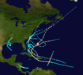
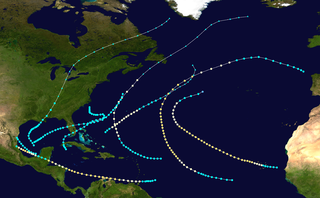
The 1893 Atlantic hurricane season ran through the summer and the first half of fall in 1893. The 1893 season was fairly active, with 12 tropical storms forming, 10 of which became hurricanes. Of those, five became major hurricanes. This season proved to be a very deadly season, with two different hurricanes each causing over 2,000 deaths in the United States; at the time, the season was the deadliest in U.S. history. The season was one of two seasons on record to see four Atlantic hurricanes active simultaneously, along with the 1998 Atlantic hurricane season. Additionally, August 15, 1893 was the only time since the advent of modern record keeping that three storms have formed on the same day (Hurricanes Four, Five, and Six) until 2020 saw Wilfred, Alpha, and Beta forming on the same day; and for the first time, there were two high-intensity hurricanes simultaneously in one month of August, and this was not repeated until the year 2023.[clarify]
Observations from ships indicated the presence of a tropical storm in the Bay of Campeche on June12.[1] The storm moved northeastward across the Gulf of Mexico and intensified into a strong tropical storm. Around 23:00UTC on June15, the system made landfall southwest of Perry, Florida, with winds of 70mph (110km/h). The cyclone weakened somewhat while moving over Florida and coastal portions of Georgia and the Carolinas. After emerging into the Atlantic near the North Carolina–Virginia state line early on June17, the storm strengthened, reaching hurricane intensity later that day.[2] On June19, a ship located in the vicinity of the storm recorded a barometric pressure around 999mbar (29.5inHg) - the lowest in relation to the cyclone.[1] However, the system then became losing tropical characteristics and transitioned into an extratropical cyclone about 155mi (250km) south of Saint Pierre and Miquelon by 00:00UTC on June20.[2]
Observations of this storm began as early as July4 in the southwestern Caribbean Sea,[1] with a ship encountering the cyclone about 130mi (210km) north-northeast of Colón, Panama. The system intensified steadily while moving northwestward, becoming a hurricane around 12:00UTC on the following day. About six hours later, the storm intensified into a Category2 hurricane and peaked with winds of 100mph (155km/h). The hurricane then made landfall near the Nicaragua–Honduras border. The cyclone weakened back to a Category1 before re-emerging into the Caribbean off the north coast of Honduras early on July6. Continuing northwestward, the system then re-strengthened slightly, reaching winds of 90mph (150km/h) prior to making landfall in northern Belize around 00:00UTC on July7. The cyclone weakened rapidly over the Yucatán Peninsula and dissipated just offshore Tabasco several hours later.[2]
The storm sank several ships, including many steamers loaded with fruit in Honduras. About 6,000bunches of bananas awaiting shipment were washed away at Bonito, while fruit plantations also experienced extensive damage. A number of homes on Roatán were also severely damaged.[3] The hurricane reportedly caused a large loss of life.[1] It has been paleotempestologically traced in sediment near Gales Point in Belize.[4]
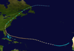
The third storm of the season formed on August 13 east of the Lesser Antilles. It steadily strengthened to a hurricane while moving over the Leeward Islands. While approaching Puerto Rico on August 16, its winds increased to major hurricane status before landfall at Patillas. It crossed the island and exited near Isabela.[5] There were heavy rains over the island of Puerto Rico and damages to the agricultural crops, especially coffee. In San Juan 2.36inches of rain were reported.[5] The eye remained over Puerto Rico for a period of seven hours. The lowest barometric pressure reading recorded in San Juan was 29.17inches. Four deaths were reported. This was the first hurricane in Puerto Rico where flags were used to alert the public about the danger of an approaching hurricane; they were flown from government buildings.[5][6]
Although landfall weakened the storm, the storm regained major hurricane status as it approached the Bahamas. It then re curved northward and on August 22, made landfall in St. Margaret's Bay near Halifax, Nova Scotia as a non-tropical category 1. The storm was known in Nova Scotia as "the second Great August Gale" and claimed 25 lives, including the sinking of the vessels "Dorcas" and "Etta Stewart."[7]
This hurricane was one of four active hurricanes on August 22.[citation needed]
The 4th storm of the season began in the Central Tropical Atlantic on August 15. The storm moved west-northwestward for the first week, strengthening while on its way. As it reached Category3 strength, it moved more northwestward. Cooler waters weakened the storm, but it managed to make landfall directly in New York City as an 85mph (137km/h) hurricane. It was one of only two hurricanes to directly hit New York City throughout the 19th century, with the other being the 1821 Norfolk and Long Island hurricane. This storm was one of four active hurricanes on August 22.[citation needed]
Hurricane Five
Category 2hurricane(SSHWS)
Duration
August 15– August 19
Peak intensity
100mph (155km/h) (1-min);
The 5th storm of the season formed east of Bermuda on August 15. After moving northwestward for a day, it moved northeastward and strengthened to a Category2 hurricane. The storm crossed over Sable Island at peak intensity, before making landfall in the Burin Peninsula of Newfoundland on August 18 as a 90mph(145km/h) hurricane. The storm dissipated on August 19.[citation needed] Climate researcher Michael Chenoweth proposed the removal of this system from HURDAT, finding "No convincing evidence for a tropical system" and arguing that data instead favored an extratropical cyclone.[8]
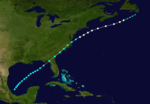
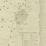
Although no observations for this storm could be found prior to August22, José Fernández-Partagás and Henry F. Diaz and the Atlantic hurricane reanalysis project retained C. J. Neumann's 1993review of the system, which began the track on August15.[9][2] Located near the west coast of Africa, the tropical storm initially moved west-southwestward, passing through the Cabo Verde Islands on August16 and August17. By the following day, the system curved west-northward, and on August19, intensified into a hurricane. The storm became a Category3 early on August23. Three days later, the hurricane curved northwestward while passing through the northern Bahamas, crossing or passing near Eleuthera, the Abaco Islands, and Grand Bahama. Curving north-northwestward on August27, the cyclone remained just offshore Florida, and made landfall near Ossabaw Island, Georgia, early on August28. Based on Savannah recording a barometric pressure of 954mbar (28.2inHg), the storm is estimated to have peaked with winds of 120mph (195km/h). The system weakened to a tropical storm as it curved northeastward over the Carolinas on August29. After crossing the Mid-Atlantic, New England, and New Brunswick, the storm became extratropical over eastern Quebec by the following day. On September2, the remnants were last noted over the far north Atlantic.[2]
In the Bahamas, significant impacts were reported on the Abaco Islands, particularly at Marsh Harbour, with damage being "very large to houses, wharves, fences, boats, fields and in fact everything", according to The Nassau Guardian.[10] Several sponging vessels sank at the Abaco Islands. The captain of the ship Sarah Emma reported flooding on Grand Bahama, which destroyed crops.[11] In Florida, the storm downed hundreds of trees and partially or fully deroofed dozens of buildings, some as far as 50mi (80km) inland. Storm surge and abnormally high tides also caused damage, especially along the First Coast.[12] Farther north, strong winds unroofed hundreds of buildings in Savannah, Georgia, where the hurricane was compared to a storm in 1881.[13] However, the elevation and distance from the coast of the city left it relatively unscathed compared to the Sea Islands. Storm surge and abnormally high tides in South Carolina extensively flooded the islands and the cities of Beaufort, Charleston, and Port Royal,[1] which reportedly had no structures elevated more than 2ft (0.61m) above ground.[14] The National Hurricane Center places the death toll between 1,000–2,000, mostly in the Sea Islands,[15] while the Red Cross estimated that approximately 30,000survivors in the region became destitute.[16] In North Carolina, high tides wrecked a number of vessels along the coast or just offshore. High winds caused severe impacts in Kernersville, including one death and the destruction of about 100homes.[17]
Hurricane Seven
Category 2hurricane(SSHWS)
Duration
August 20– August 29
Peak intensity
100mph (155km/h) (1-min);
The official track for this storm begins on August20 to the southwest of the Cabo Verde Islands,[2] similar to the paths created by Charles Mitchell in 1924 and C. J. Neumann in 1993. Although very little information could be found in relation to the storm,[9] it moved west-northwestward and is estimated to have intensified into a hurricane on August22. By the following day, the system strengthened into a Category2 hurricane with winds of 100mph (155km/h). Turning northeastward on August26, the hurricane crossed the Azores, moving near Faial Island. The cyclone weakened to a tropical storm early on August29 and was last noted northeast of the Azores several hours later.[2]
The hurricane destroyed 14homes on Faial Island and 28others on Terceira Island and ruined crops.[9][18] Three ships in the vicinity of the Azores were lost, while two remained missing by September2. At least five people died in the archipelago.[18]
The 8th storm of the season formed in the western Caribbean Sea on September 4. After hitting the Yucatán Peninsula, it strengthened in the Gulf of Mexico to a 95mph(153km/h) hurricane. It hit the southern coast of Louisiana on September 7, and dissipated over northeastern Alabama.[citation needed]
Heavy rains fell over southern Louisiana, including a peak total of 15.2in (390mm) in Franklin, while Donaldsonville, Emilie, and Wallace broke 24-hour precipitation records for the month of September. Extensive losses to cotton, rice, and sugar occurred in St. Martin and St. Maryparishes, while East Feliciana Parish reported severe damage to oranges.[19] In Lockport, a tornado killed five people, injured seventeen others, and inflicted about $40,000 in damage. The storm also dropped heavy rain in Mobile, Alabama, and Pensacola, Florida.[20]
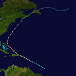
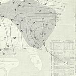
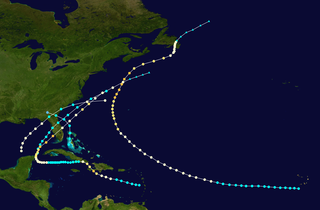
The Great Charleston Hurricane of 1893 The ninth known tropical cyclone of the season formed southwest of Cape Verde on September25. It moved westward and intensified into a hurricane on September28, before turning northwestward on October2. By then, the system strengthened into a Category3 hurricane and likely peaked with maximum sustained winds of 120mph (195km/h). The hurricane then moved west-northwestward for several days, beginning on October6. After passing just north of the Abaco Islands on October12, the storm curved northwestward and then north-northwestward, remaining closely offshore Florida and Georgia. The hurricane then turned northeastward and at around 13:00UTC on October13, it made landfall near McClellanville, South Carolina, winds of 120mph (195km/h) and a barometric pressure of 955mbar (28.2inHg). Moved rapidly northward through North Carolina and the Appalachian Mountains, the cyclone was still a Category1 hurricane as it passed 60mi (95km) west of Washington, D.C. The storm transitioned into an extratropical cyclone over far southern Quebec on October14 after crossing Lake Ontario and continued northeastward until dissipating over the northeastern portions of the province on the following day.[2]
In the Bahamas, abnormally high tides inundated some streets on New Providence and nearby Hog Island, sweeping away the home of the assistant lighthouse keeper. The storm severely damaged pineapple cultivation facilities on Eleuthera and plantations on the Abaco Islands, where many other buildings were destroyed.[9] In Florida, storm surge reached several feet above ground between Palm Beach and Jacksonville, while heavy rains fell, leading to flooding in a number of coastal communities.[21] Storm surge and abnormally high tides in Georgetown, South Carolina, exceeded the heights of those measured in the August hurricane. An estimated 15deaths occurred in the state,[22] while the National Hurricane Center lists the combined toll for Florida and South Carolina at 28.[15] Waves reached the then-record highest height in Wilmington, North Carolina, causing about $150,000 in damage to the waterfront. The state also suffered "great destruction ... to forests, crops and property, and to shipping.", according to a 2000 report by National Weather Service meteorologist James E. Hudgins. A total of 22fatalities were reported in North Carolina.[17]
Strong winds in Virginia partially deroofed homes and downed several trees in Richmond, while the storm destroyed barns and outhouses and toppled many electrical lines in Petersburg. The Roanoke River rose significantly at Roanoke, causing washouts along the Norfolk and Western Railway. The river also overflowed into Elliston, washing away residences. High tides destroyed the wharves at Alexandria, causing about $25,000 in damage, and capsized the Edward Ewing. Gale-force winds downed trees, limbs, and a church wall in Washington, D. C. Four vessels suffered damage or capsized. In Maryland, the electric light plant burned down in Baltimore, while winds downed fences and partly deroofed some residences in Bladensburg.[23] Two prisoners died after the fire spread to the jail. Several Pennsylvania towns reported downed trees, unroofed dwellings, disrupted telegraph service, and delayed traffic on railroads. In New Jersey, the storm washed out several parts of the West Jersey Railroad, downed many telegraph wires, and beached several vessels.[22] Strong winds over western New York downed many lines, unroofed a number of structures, and destroyed four cottages and a railroad depot in Buffalo, causing three deaths. The center crossed Lake Ontario, sinking 10ships and stranding 29others, leading to the loss of 54lives. Another person died after being blown into the Niagara River.[24] Winds also downed some trees and wires in New England.[22]
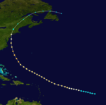
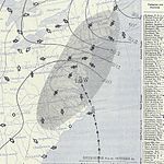
Although meteorologist José Fernández Partagás noted a "lack of suitable information" prior to October1,[9]the official track for this system begins on September27 to the northeast of Honduras. The storm headed northwestward and intensified into a hurricane on the next day. Thereafter, the cyclone brushed Cozumel and then made landfall in Mexico's Yucatán Peninsula near Puerto Morelos as a Category2 hurricane early on September29. The storm continued northwestward until late on October1, at which time a northeasterly motion commenced. While nearing the Gulf Coast of the United States, the system intensified significantly, peaking as a Category4 hurricane with winds of 130mph (215km/h) and a minimum pressure of 948mbar (28.0inHg) at 06:00UTC on October2. Two hours later, the hurricane struck near Cheniere Caminada, Louisiana, at the same intensity and then another made landfall eight hours thereafter near Ocean Springs, Mississippi, as a strong Category2 hurricane. The cyclone weakened to a tropical storm over Alabama early on October3. Retaining tropical storm intensity while crossing the Southeastern United States, the storm emerged into the Atlantic from the Outer Banks of North Carolina on October4 but likely dissipated on the following day.[2]
Strong winds and storm surge left extensive effects in southeastern Louisiana, with towns between New Orleans and Port Eads suffering major damage, while other communities such Cheniere Caminada and Grand Isle also experienced extreme impacts. Some bays along the south coast observed storm surge reaching 15ft (4.6m), while the Chandeleur Islands recorded a storm surge of 16ft (4.9m).[19] The Thibodaux Sentinel noted that Cheniere Caminada had been "swept out of existence.", with few homes remaining standing and 779residents being killed.[25] At nearby Grand Isle, none of the summer homes and hotels survived the storm due to storm surge and tides inundating the area with water 9ft (2.7m) above ground.[9][19] Extensive crop damage also occurred along both sides of the lower Mississippi River. The hurricane destroyed at least four churches across the state and caused about $5million in damage to property alone. Approximately 2,000deaths occurred as a result of the storm.[19] In coastal Mississippi, storm surge washed hundreds of feet of a railroad bridge between Biloxi and Ocean Springs into several buildings. The storm also damaged a saw mill, a ship yard, several canning facilities, many wharves, bathhouses, and some homes.[26] Abnormally high tides and storm surge in Alabama caused damage, especially in the Mobile area, with the commerce district submerged with 4ft (1.2m) of water. Seven deaths occurred in the state. In Florida, The New York Times noted that "on every street, uprooted trees, broken fences and roofless buildings testify of the storm's force" in Pensacola. Storm surge caused washouts that disrupted rail service and shipping. Several other places in the Southeastern United States reported heavy rainfall.[9]
Tropical Storm Eleven
Tropical storm(SSHWS)
Duration
October 20– October 23
Peak intensity
60mph (95km/h) (1-min);
The 11th storm of the season formed just south of the Isla de la Juventud on October 20. After moving through Cuba, it strengthened to a 60mph(97km/h) storm before it hit the Delmarva Peninsula on October 23.[citation needed] Chenoweth proposed removing the cyclone from HURDAT, noting that it was "most likely an extratropical system".[8]
Tropical Storm Twelve
Tropical storm(SSHWS)
Duration
November 5– November 9
Peak intensity
70mph (110km/h) (1-min);
A low-pressure became a tropical storm on November5,[9] situated about 385mi (620km) east of Marsh Harbour in the Bahamas,[2] though Partagás noted the possibility of the system having subtropical characteristics.[9] The storm gradually turned west-northward and then northward. On November8, the cyclone passed within 50mi (80km) of the Outer Banks of North Carolina with winds of 70mph (110km/h) but curved northeastward and remained offshore. The system then shifted east-northeastward on November9 and transitioned into an extratropical storm that day. The extratropical remnants dissipated near the Azores on November12.[2] The 2014study by Chenoweth suggested the removal this system from HURDAT, noting "Daily weather maps indicate that this is most likely an extratropical system".[8]
In North Carolina, the town of Kitty Hawk observed sustained winds of 58mph (93km/h). Offshore the Mid-Atlantic and New England, 14coal barges encountered rough seas generated by the storm, several of which later sank. An unidentified steamship near the Delaware Breakwater also became disabled but was towed to safety by the bark Clan Ferguson.[9]
The 1909 Atlantic hurricane season was an average Atlantic hurricane season. The season produced thirteen tropical cyclones, twelve of which became tropical storms; six became hurricanes, and four of those strengthened into major hurricanes. The season's first storm developed on June 15 while the last storm transitioned into an extratropical cyclone on November 14. The most notable storm during the season formed in late August, while east of the Lesser Antilles. The hurricane devastated the Lesser Antilles, the Greater Antilles, and Mexico, leaving around 4,000 fatalities and more than $50 million (1909 USD) in damage.
The 1908 Atlantic hurricane season was an active Atlantic hurricane season. Thirteen tropical cyclones formed, of which ten became tropical storms; six became hurricanes, and one of those strengthened into a major hurricane – tropical cyclones that reach at least Category 3 on the modern day Saffir–Simpson scale. The season's first system developed on March 6, and the last storm transitioned into an extratropical cyclone on October 23.
The 1903 Atlantic hurricane season featured seven hurricanes, the most in an Atlantic hurricane season since 1893. The first tropical cyclone was initially observed in the western Atlantic Ocean near Puerto Rico on July 21. The tenth and final system transitioned into an extratropical cyclone well northwest of the Azores on November 25. These dates fall within the period with the most tropical cyclone activity in the Atlantic. Six of the ten tropical cyclones existed simultaneously.
The 1901 Atlantic hurricane season was the most active season without a major hurricane – tropical cyclones that reach at least Category 3 on the Saffir–Simpson hurricane wind scale – until 2013. The first system was initially observed in the northeastern Caribbean on June 11. The fourteenth and final system transitioned into an extratropical cyclone near Bermuda on November 5. These dates fall within the period with the most tropical cyclone activity in the Atlantic. Eight of the fourteen tropical cyclones existed simultaneously.
The 1900 Atlantic hurricane season featured the Galveston hurricane, the deadliest natural disaster in the history of the United States. A total of 10 tropical cyclones formed, seven of which intensified into a tropical storm. Three of those made landfall in the United States. The first system was initially observed over the central Atlantic Ocean on January 17, while the final storm transitioned into an extratropical cyclone on October 28. These dates fall within the period with the most tropical cyclone activity in the Atlantic. Every storm of the season except the seventh system existed simultaneously with another tropical cyclone.
The 1899 Atlantic hurricane season featured the longest-lasting tropical cyclone in the Atlantic basin on record. There were nine tropical storms, of which five became hurricanes. Two of those strengthened into major hurricanes, which are Category 3 or higher on the modern day Saffir–Simpson scale. The first system was initially observed in the northeastern Gulf of Mexico on June 26. The tenth and final system dissipated near Bermuda on November 10. These dates fall within the period with the most tropical cyclone activity in the Atlantic. In post-season analysis, two tropical cyclones that existed in October were added to HURDAT – the official Atlantic hurricane database. At one point during the season, September 3 through the following day, a set of three tropical cyclones existed simultaneously.
The 1898 Atlantic hurricane season marked the beginning of the Weather Bureau operating a network of observation posts across the Caribbean Sea to track tropical cyclones, established primarily due to the onset of the Spanish–American War. A total of eleven tropical storms formed, five of which intensified into a hurricane, according to HURDAT, the National Hurricane Center's official database. Further, one cyclone strengthened into a major hurricane. However, in the absence of modern satellite and other remote-sensing technologies, only storms that affected populated land areas or encountered ships at sea were recorded, so the actual total could be higher. An undercount bias of zero to six tropical cyclones per year between 1851 and 1885 and zero to four per year between 1886 and 1910 has been estimated. The first system was initially observed on August 2 near West End in the Bahamas, while the eleventh and final storm dissipated on November 4 over the Mexican state of Veracruz.
The 1897 Atlantic hurricane season was an inactive season, featuring only six known tropical cyclones, four of which made landfall. There were three hurricanes, none of which strengthened into major hurricanes, which are Category 3 or higher on the modern-day Saffir–Simpson hurricane wind scale. The first system was initially observed south of Cape Verde on August 31, an unusually late date. The storm was the strongest of the season, peaking as a Category 2 hurricane with winds of 100 mph (155 km/h). While located well north of the Azores, rough seas by the storm sunk a ship, killing all 45 crewmen. A second storm was first spotted in the Straits of Florida on September 10. It strengthened into a hurricane and tracked northwestward across the Gulf of Mexico, striking Louisiana shortly before dissipating on September 13. This storm caused 29 deaths and $150,000 (1897 USD) in damage.
The 1895 Atlantic hurricane season was a fairly inactive one, featuring only six known tropical cyclones, although each of them made landfall. Of those six systems, only two intensified a hurricane, while none of those strengthened into a major hurricane. However, in the absence of modern satellite and other remote-sensing technologies, only storms that affected populated land areas or encountered ships at sea were recorded, so the actual total could be higher. An undercount bias of zero to six tropical cyclones per year between 1851 and 1885 and zero to four per year between 1886 and 1910 has been estimated.
The 1894 Atlantic hurricane season ran through the summer and the first half of fall in 1894. The 1894 season was a fairly inactive one, with seven storms forming, five of which became hurricanes.
The 1892 Atlantic hurricane season included the last tropical cyclone on record to pass through the Cabo Verde Islands at hurricane intensity until 2015. A total of nine tropical storms developed, five of which strengthened into a hurricane, though none of them became a major hurricane. However, in the absence of modern satellite and other remote-sensing technologies, only storms that affected populated land areas or encountered ships at sea were recorded, so the actual total could be higher. An undercount bias of zero to six tropical cyclones per year between 1851 and 1885 and zero to four per year between 1886 and 1910 has been estimated. Three tropical storms made landfall on the United States.
The 1891 Atlantic hurricane season began during the summer and ran through the late fall of 1891. The season had ten tropical cyclones. Seven of these became hurricanes; one becoming a major Category 3 hurricane.
The 1884 Atlantic hurricane season was one of only three Atlantic hurricane seasons, along with 1852 and 1858, in which every known tropical cyclone attained hurricane status. Overall, four tropical cyclones developed, three of which made landfall. The first system was initially observed over the northwestern Atlantic Ocean on September 1. It struck Newfoundland the following day, but impact there is unknown. On September 3, the next hurricane developed, though it did not affect land in its duration. The third hurricane struck Georgia, accompanied by damaging waves in north Florida.
The 1887 Atlantic hurricane season was the most active Atlantic hurricane season on record at the time in terms of the number of known tropical storms that had formed, with 19. This total has since been equaled or surpassed multiple times. The 1887 season featured five off-season storms, with tropical activity occurring as early as May, and as late as December. It is also worthy of note that the volume of recorded activity was documented largely without the benefit of modern technology. Tropical cyclones during this era did not approach populated areas or shipping lanes, especially if they were relatively weak and of short duration, may have remained undetected. Because technologies such as satellite monitoring were not available until the 1960s, historical data on tropical cyclones from this period may not be comprehensive. An undercount bias of zero to six tropical cyclones per year between 1851 and 1885 and zero to four per year between 1886 and 1910 has been estimated. Of the known 1887 cyclones, Tropical Storm One and Tropical Storm Three were first documented in 1996 by Jose Fernandez-Partagas and Henry Diaz. They also proposed large alterations to the known tracks of several of the other 1887 storms. Later re-analysis led to the known duration of Hurricane Six, and also that of Hurricane Fifteen, being increased.
The Chenière Caminada hurricane, also known as the Great October Storm, was a powerful hurricane that devastated the island of Cheniere Caminada, Louisiana in early October 1893. It was one of three deadly hurricanes during the 1893 Atlantic hurricane season; the storm killed an estimated 2,000 people, mostly from storm surge. The high death toll ranks the hurricane as the deadliest hurricane in Louisiana history and the third deadliest hurricane in the continental U.S., behind only the 1900 Galveston hurricane and the 1928 Okeechobee hurricane.
The 1888 Atlantic hurricane season ran through the summer and the first half of fall in 1888. In the 1888 Atlantic season there were two tropical storms, four hurricanes, and two major hurricanes. However, in the absence of modern satellite and other remote-sensing technologies, only storms that affected populated land areas or encountered ships at sea are known, so the actual total could be higher. An undercount bias of zero to six tropical cyclones per year between 1851 and 1885 and zero to four per year between 1886 and 1910 has been estimated.
The 1881 Atlantic hurricane season ran through the summer and early fall of 1881. This is the period of each year when most tropical cyclones form in the Atlantic basin. In the 1881 Atlantic season there were three tropical storms and four hurricanes, none of which became major hurricanes. However, in the absence of modern satellite and other remote-sensing technologies, only storms that affected populated land areas or encountered ships at sea were recorded, so the actual total could be higher. An undercount bias of zero to six tropical cyclones per year between 1851 and 1885 and zero to four per year between 1886 and 1910 has been estimated. Of the known 1881 cyclones, Hurricane Three and Tropical Storm Seven were both first documented in 1996 by Jose Fernandez-Partagas and Henry Diaz. They also proposed changes to the known tracks of Hurricane Four and Hurricane Five.
The 1854 Atlantic hurricane season featured five known tropical cyclones, three of which made landfall in the United States. At one time, another was believed to have existed near Galveston, Texas in September, but HURDAT – the official Atlantic hurricane database – now excludes this system. The first system, Hurricane One, was initially observed on June 25. The final storm, Hurricane Five, was last observed on October 22. These dates fall within the period with the most tropical cyclone activity in the Atlantic. No tropical cyclones during this season existed simultaneously. One tropical cyclone has a single known point in its track due to a sparsity of data.
The 1873 Atlantic hurricane season was quiet, featuring only five known tropical cyclones, but all of them made landfall, causing significant impacts in some areas of the basin. Of these five systems, three intensified into a hurricane, while two of those attained major hurricane status. However, in the absence of modern satellite and other remote-sensing technologies, only storms that affected populated land areas or encountered ships at sea were recorded, so the actual total could be higher. An undercount bias of zero to six tropical cyclones per year between 1851 and 1885 and zero to four per year between 1886 and 1910 has been estimated.
The 1872 Atlantic hurricane season included a storm whose track became one of the first to be published by the United States Army Signal Service, a predecessor of the National Weather Service. The season was quiet, with only five documented tropical cyclones, of which four attained hurricane status. None of them intensified into a major hurricane. However, in the absence of modern satellite and other remote-sensing technologies, only storms that affected populated land areas or encountered ships at sea were recorded, so the actual total could be higher. An undercount bias of zero to six tropical cyclones per year between 1851 and 1885 and zero to four per year between 1886 and 1910 has been estimated.
1 2 3 Mújica-Baker, Frank. Huracanes y Tormentas que han afectadi a Puerto Rico(PDF). Estado Libre Asociado de Puerto Rico, Agencia Estatal para el manejo de Emergencias y Administracion de Desastres. p.10. Archived from the original(PDF) on September 24, 2015. Retrieved August 30, 2010.
1 2 3 4 5 6 7 8 9 10 Partagás, José Fernández; Diaz, Henry F. (1996). Year 1893(PDF). Atlantic Oceanographic and Meteorological Laboratory (Report). Miami, Florida: National Oceanic and Atmospheric Administration. pp.49–65. Retrieved September 5, 2023.
1 2 Rappaport, Edward N.; Partagás, José Fernández; Beven, Jack (April 22, 1997). "Appendix 1. Cyclones with 25+ Deaths". The Deadliest Atlantic Tropical Cyclones, 1492-1996 (Report). National Hurricane Center. Retrieved September 5, 2023.
↑ Roth, David; Cobb, Hugh (July 16, 2001). "Late Nineteenth Century Virginia Hurricanes". Virginia Hurricane History (Report). Weather Prediction Center. Retrieved December 9, 2023.
This page is based on this Wikipedia article Text is available under the CC BY-SA 4.0 license; additional terms may apply. Images, videos and audio are available under their respective licenses.