
Swissair Flight 111 (SR111/SWR111) was a scheduled international passenger flight from John F. Kennedy International Airport in New York City, United States, to Cointrin Airport in Geneva, Switzerland. The flight was also a codeshare flight with Delta Air Lines. On 2 September 1998, the McDonnell Douglas MD-11 performing this flight, registration HB-IWF, crashed into the Atlantic Ocean southwest of Halifax Stanfield International Airport at the entrance to St. Margarets Bay, Nova Scotia. The crash site was 8 kilometres from shore, roughly equidistant from the small fishing and tourist communities of Peggy's Cove and Bayswater, killing all 229 passengers and crew on board the MD-11, making the crash the deadliest accident in the history of Swissair and the deadliest accident involving the McDonnell Douglas MD-11. It is also the second-deadliest aviation accident to occur in Canada, behind Arrow Air Flight 1285R.

Peggy's Cove is a small rural community located on the eastern shore of St. Margarets Bay in the Halifax Regional Municipality, which is the site of Peggys Cove Lighthouse.
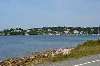
Glen Haven is a small coastal community within the Halifax Regional Municipality of Nova Scotia, Canada, about 40 km from Halifax city centre. It is situated on the shore of the St. Margarets Bay immediately adjacent to Tantallon and French Village along Route 333, also known as Peggy's Cove Road.
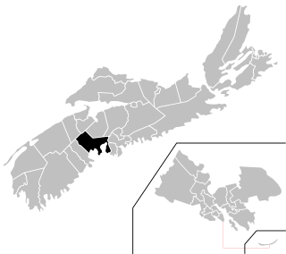
Chester—St. Margaret's is a provincial electoral district in Nova Scotia, Canada, that elects one member of the Nova Scotia House of Assembly. It is located on the South Shore.
The Aspotogan Peninsula is a peninsula in the eastern part of Lunenburg County, Nova Scotia, separating St. Margarets Bay in the east from Mahone Bay in the west. The peninsula was originally settled by second generation French immigrants on the east side and by second generation German immigrants on the west side. Traditionally fishing was a major industry for communities throughout the peninsula, however other primary industries such as farming and forestry were historically important as well. Shipping and shipbuilding were secondary and tertiary industries that also came into prominence during the 19th and early 20th centuries.

Nova Scotia Trunk 3 is an east-west trunk highway in Nova Scotia. The route runs from Halifax to Yarmouth, along the South Shore. Trunk 3's status as an important regional highway link has been superseded by the parallel Highway 103.

Route 333 is a collector road in the Canadian province of Nova Scotia.
The Lighthouse Route is a scenic roadway in the Canadian province of Nova Scotia. It follows the province's South Shore for 585 km (364 mi) from Halifax to Yarmouth.
Route 329 is a collector road in the Canadian province of Nova Scotia.
Hubbards is an unincorporated Canadian rural community on the South Shore of Nova Scotia.

Nova Scotia is a province located in Eastern Canada fronting the Atlantic Ocean. One of the Maritime Provinces, Nova Scotia's geography is complex, despite its relatively small size in comparison to other Canadian provinces.
Canadian Forces Station Mill Cove is a former Canadian Forces Station and currently a naval radio station located near Hubbards, Nova Scotia. Built in 1967, it is remotely operated by the Canadian Forces from CFB Halifax.
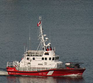
CCGS Sambro is a Canadian Coast Guard motor lifeboat homeported in Sambro, Nova Scotia.
Micou's Island is a 22-acre (89,000 m2) tidal island located in the Glen Haven community near the eastern shore of St. Margarets Bay, Nova Scotia, Canada. The island is accessible by a sandbar at low tide and has become a popular beach during summer months.

French Village is a rural community of the Halifax Regional Municipality in the Canadian province of Nova Scotia on Chebucto Peninsula. French village initially included present day villages of Tantallon, Glen Haven and French Village. The French that migrated to the area were French speaking families from the Principality of Montbeliard and known as the "Foreign Protestants". They had come to Nova Scotia between 1750 and 1752 to settle Lunenburg, Nova Scotia. Contrary to belief, they were not Huguenots. The church is the community is St. Paul's Church. In 1901, the Halifax and Southwestern Railway was built through the area and the railway choose the name French Village for the station serving the three communities. The French Village station, actually located in Tantallon, has been preserved as a cafe beside the recreational trail that follows the old Halifax & Southwestern Railway roadbed.

Indian Harbour is a small fishing community of the Halifax Regional Municipality in the Canadian province of Nova Scotia on the Chebucto Peninsula. It is located between the communities of Peggy's Cove and Hackett's Cove.

Bayswater is a community in the Canadian province of Nova Scotia, located in the Chester Municipal District on the Aspotogan Peninsula in Lunenburg County on the Lighthouse Route. The community is home to Bayswater Beach Provincial Park, Swissair 111 Memorial, and All Saints Anglican Church.
Mill Cove is a community in the Canadian province of Nova Scotia, located in the Chester Municipal District on the Aspotogan Peninsula on the Lighthouse Route. The community was home to CFS Mill Cove from 1967 til the 1990s.


