Indian Harbour, Nova Scotia

Last updated

Indian Harbour Indian Harbour NS.JPG
Indian Harbour

Indian Harbour is a small fishing community of the Halifax Regional Municipality in the Canadian province of Nova Scotia on the Chebucto Peninsula. It is located between the communities of Peggy's Cove and Hackett's Cove.

Contents

History

Indian Harbour was founded in the early 18th century.[ citation needed ] The first recorded person to live in Indian Harbour was John Ormsby in 1784.[ citation needed ] The first and the oldest house in Indian Harbour is still standing today at the age of over 250 years.[ citation needed ]

Indian Harbour is located next to the popular tourist destination Peggy's Cove and its famous lighthouse. There is also a lighthouse in Indian Harbour, located at the end of Paddy's Head Peninsula. The lighthouse was built in 1901 and manned until 1945, when power was introduced to the area. [1]

Indian Harbour's roads were dirt and had to be up kept by the locals until 1955 when Route 333 was widened and paved.[ citation needed ]

In recent years one of Canada's biggest air disasters took place over the Atlantic Ocean near St. Margarets Bay. On September 2, 1998, Swissair Flight 111 crashed just off the coast; all 229 people on board died. Today in the memory of all 229 crew and passengers there is a memorial in the community just before entering the Peggy's Cove area.

Nova Scotian singer Anne Murray use to own a beach in Indian Harbour, on the Paddy's Head Peninsula, she allowed the public to use the beach, but the property was sold in 1999.[ citation needed ]

Schools

Indian Harbour has had three schools in its history. The first school was built in 1878 and is said to have burnt down; it was located on the Government Wharf Road, 50 yards from the Baptist church.[ citation needed ] In 1891 the second school was built where East St. Margaret's Elementary currently stands.[ citation needed ] This school served the communities of Hackett's Cove, Indian Harbour and Peggy's Cove. On November 18, 1958, East St Margaret's Elementary School opened its doors. The school served grades primary to twelve; in 1966 the grades were reduced to primary to eight; when Tantallon Junior High opened in 1972, the grades were reduced to primary to six. Today East St. Margaret's is still serving Indian Harbour. The school has room for 198 students.

Swissair Flight 111

Swissair 111 Memorial near Peggy's Cove Swissair 111 Memorial near Peggys Cove.jpg
Swissair 111 Memorial near Peggy's Cove

On September 2, 1998, Swissair Flight 111 crashed into St. Margaret's Bay with the loss of all 229 aboard. One of two memorials to the victims of the disaster is located at The Whalesback, in Indian Harbour. The other is located at Bayswater, Nova Scotia, on the Aspotogan Peninsula on the western shore of the bay. The two monuments and the actual crash site are at the vertices of a roughly equilateral triangle across the bay.

The monument at Whalesback reads in English and French: "In memory of the 229 men, women and children aboard Swissair Flight 111 who perished off these shores September 2nd, 1998. They have been joined to the sea, and the sky. May they rest in peace."

The three notches represent the numerals 111. The sight line from the three grooves in the stone points to the crash site, while the markings on the facing stone point to the memorial at Bayswater. The memorial wall at Bayswater contains the names of the 229 passengers and crew of Flight 111. The facing stone points to the crash site.

Transit

Currently there are no buses running from Halifax to Indian Harbour; the closest bus route is in Tantallon where the "MetroX" and Metro Transit run busses from Tantallon to Halifax.

Television

Indian Harbour gets all of the local television from Halifax. The following television stations air in St. Margarets Bay:

Local business

Local businesses include Rhubarb Restaurant, Make and Break Cafe, YardArm Restaurant, the King Neptune Campground, the Oceanstone Inn and Cottages, [2] and the Clifty Cove Motel. [3] Indian Harbour only has one store, the Whale's Back; locals call it "the store". The Whale's Back serves people from West Dover to Glen Haven and tourists in the summer; it has the same owners as the Sou' Wester Restaurant & Giftshop in Peggy's Cove.[ citation needed ]

Related Research Articles

<span class="mw-page-title-main">Swissair Flight 111</span> Aviation accident in 1998

Swissair Flight 111 was a scheduled international passenger flight from John F. Kennedy International Airport in New York City, United States, to Cointrin Airport in Geneva, Switzerland. This flight was also a codeshare flight with Delta Air Lines. On 2 September 1998, the McDonnell Douglas MD-11 performing this flight, registration HB-IWF, crashed into the Atlantic Ocean southwest of Halifax Stanfield International Airport at the entrance to St. Margarets Bay, Nova Scotia. The crash site was 8 kilometers from shore, roughly equidistant from the small fishing and tourist communities of Peggy's Cove and Bayswater. All 229 passengers and crew on board the MD-11 were killed, making the crash the deadliest accident in the history of Swissair and the deadliest accident involving McDonnell Douglas MD-11.

<span class="mw-page-title-main">Peggy's Cove, Nova Scotia</span> Place in Nova Scotia, Canada

Peggy's Cove is a small rural community located on the eastern shore of St. Margarets Bay in the Halifax Regional Municipality, which is the site of Peggys Cove Lighthouse.

<span class="mw-page-title-main">Halifax Peninsula</span> Place in Nova Scotia, Canada

The Halifax Peninsula is peninsula within the urban area of the Municipality of Halifax, Nova Scotia.

<span class="mw-page-title-main">St. Margarets Bay, Nova Scotia</span>

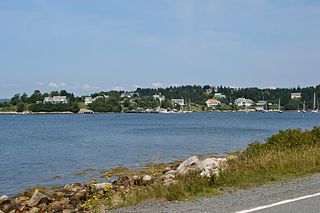
St. Margarets Bay is a bay located on the Atlantic coast of Nova Scotia, Canada on the border of Halifax County and Lunenburg County.

<span class="mw-page-title-main">Glen Haven, Nova Scotia</span> Rural Community in Nova Scotia, Canada

Glen Haven is a small coastal community within the Halifax Regional Municipality of Nova Scotia, Canada, about 40 km from Halifax city centre. It is situated on the shore of the St. Margarets Bay immediately adjacent to Tantallon and French Village along Route 333, also known as Peggy's Cove Road.

The Aspotogan Peninsula is a peninsula in the eastern part of Lunenburg County, Nova Scotia, separating St. Margarets Bay in the east from Mahone Bay in the west. The peninsula was originally settled by second generation French immigrants on the east side and by second generation German immigrants on the west side. Traditionally fishing was a major industry for communities throughout the peninsula, however other primary industries such as farming and forestry were historically important as well. Shipping and shipbuilding were secondary and tertiary industries that also came into prominence during the 19th and early 20th centuries.

<span class="mw-page-title-main">Diocese of Nova Scotia and Prince Edward Island</span> Diocese of the Anglican Church in Canada

The Diocese of Nova Scotia and Prince Edward Island is a diocese of the Ecclesiastical Province of Canada of the Anglican Church of Canada. It encompasses the provinces of Nova Scotia and Prince Edward Island and has two cathedrals: All Saints' in Halifax and St. Peter's in Charlottetown. Its de facto see city is Halifax, and its roughly 24 400 Anglicans distributed in 239 congregations are served by approximately 153 clergy and 330 lay readers according to the last available data. According to the 2001 census, 120,315 Nova Scotians identified themselves as Anglicans, while 6525 Prince Edward Islanders did the same.

<span class="mw-page-title-main">Nova Scotia Trunk 3</span> Highway in Nova Scotia, Canada

Nova Scotia Trunk 3 is an east-west trunk highway in Nova Scotia. The route runs from Halifax to Yarmouth, along the South Shore. Trunk 3's status as an important regional highway link has been superseded by the parallel Highway 103.

<span class="mw-page-title-main">Nova Scotia Route 333</span>

Route 333 is a collector road in the Canadian province of Nova Scotia.

The Lighthouse Route is a scenic roadway in the Canadian province of Nova Scotia. It follows the province's South Shore for 585 km (364 mi) from Halifax to Yarmouth.

Route 329 is a collector road in the Canadian province of Nova Scotia.

<span class="mw-page-title-main">Bay View High School (HRM)</span> High school in Upper Tantallon, Nova Scotia, Canada

Bay View High School is a Canadian high school serving the western suburbs of Nova Scotia's Halifax Regional Municipality (HRM); namely the communities of Beechville, Lakeside, Timberlea, Tantallon and communities on the western portion of highway 333 including Peggy's Cove, Seabright and others. Bay View's feeder schools are Five Bridges Junior High School and Ridgecliff Middle School.

<span class="mw-page-title-main">Hubbards, Nova Scotia</span> Place in Nova Scotia, Canada

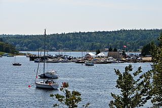
Hubbards is an unincorporated Canadian rural community on the South Shore of Nova Scotia.

<span class="mw-page-title-main">Geography of Nova Scotia</span>

Nova Scotia is a province located in Eastern Canada fronting the Atlantic Ocean. One of the Maritime Provinces, Nova Scotia's geography is complex, despite its relatively small size in comparison to other Canadian provinces.

Flight 111 may refer to:

CCGS <i>Sambro</i>

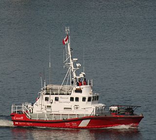
CCGS Sambro is a Canadian Coast Guard motor lifeboat homeported in Sambro, Nova Scotia.

<span class="mw-page-title-main">Peggys Cove Preservation Area, Nova Scotia</span>

Peggy's Cove Preservation Area is a preservation area and community enacted by the Nova Scotia government to preserve the unique scenic beauty, character and atmosphere of Peggy's Cove for the enjoyment of both residents and visitors within Peggy's Cove Nova Scotia mandated by the Peggy's Cove Commission Act. The area includes the Swissair Flight 111 memorial site at Whalesback.

<span class="mw-page-title-main">Bayswater, Nova Scotia</span> Place in Nova Scotia, Canada

Bayswater is a community in the Canadian province of Nova Scotia, located in the Chester Municipal District on the Aspotogan Peninsula in Lunenburg County on the Lighthouse Route. The community is home to Bayswater Beach Provincial park, Swissair 111 memorial, and All Saints Anglican Church

<span class="mw-page-title-main">Peggys Point Lighthouse</span> Lighthouse

Peggys Point Lighthouse, also known as Peggys Cove Lighthouse, is an active lighthouse and an iconic Canadian image. Located within Peggy's Cove, Nova Scotia, it is one of the busiest tourist attractions in the province and is a prime attraction on the Lighthouse Trail scenic drive. The lighthouse marks the eastern entrance of St. Margarets Bay and is officially known as the Peggys Point Lighthouse.

References

  1. "Indian Harbour (Paddy's Head), NS," accessed July 10, 2011, http://www.lighthousefriends.com/light.asp?ID=1035.
  2. "Oceanstone Inn and Cottages by the Sea," accessed July 10, 2011, http://www.oceanstone.ns.ca/ Archived 2010-02-27 at the Wayback Machine .
  3. "Clifty Cove Motel," accessed July 10, 2011, http://cliftycovemotel.com/.

Coordinates: 44°31′35.1″N63°56′23.8″W / 44.526417°N 63.939944°W / 44.526417; -63.939944