
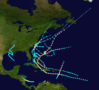
The 1961 Atlantic hurricane season was a very active Atlantic hurricane season, with an accumulated cyclone energy (ACE) total of 189, the highest since 1950 and until being surpassed by 1995. The season, however, was an average one in terms of named storms. The season featured eight hurricanes and a well above average number of five major hurricanes. It was previously thought that the season had a record-tying seven major hurricanes, before the Atlantic hurricane reanalysis project downgraded two storms in 2019. Two Category 5 hurricanes were seen in 1961, making it one of only eight Atlantic hurricane seasons to feature multiple Category 5 hurricanes in one season. The season started on June 15, and ended on November 15. These dates conventionally delimit the period of each year when most tropical cyclones form in the Atlantic basin. The first system, an operationally unclassified tropical depression, formed offshore east Central Florida on June 10, but dissipated a few days later. Next, Hurricane Anna developed in the eastern Caribbean Sea near the Windward Islands on July 20. It brought minor damage to the islands in, as well as wind and flood impacts to Central America after striking Belize as a hurricane. Anna caused one death and about $300,000 (1961 USD) in damage. Activity went dormant for nearly a month and a half, until Hurricane Betsy developed on September 2. Betsy peaked as a Category 4 hurricane, but remained at sea and caused no impact.

The 1948 Atlantic hurricane season featured the first tropical cyclone before the month of June since 1940. The season officially began on June 15, 1948, and lasted until November 15, 1948. These dates conventionally delimit the period of each year when most tropical cyclones form in the Atlantic basin. There were fifteen tropical cyclones; ten systems strengthened into a tropical storm, six storms attained hurricane status, and four storms intensified into major hurricanes, which are Category 3 or higher on the modern-day Saffir–Simpson hurricane wind scale. Operationally, it was believed that a weak tropical disturbance formed over the southeast Bahamas in May and moved northwest into the Georgia coast near Savannah. This system was later excluded from HURDAT. The seventh tropical cyclone was not operationally considered a tropical cyclone, but was later added to HURDAT.

The 1942 Atlantic hurricane season was one of seven seasons to feature multiple hurricane landfalls in Texas. The season officially lasted from June 16, 1942, to October 31, 1942. These dates conventionally delimit the period of each year when most tropical cyclones form in the Atlantic basin. A total of 11 tropical storms from 1943 are listed in the Atlantic hurricane database, with two additional tropical depressions. The first system of the year, a tropical depression, developed over the central Gulf of Mexico on June 3, while the last system, the Belize hurricane, dissipated over the Yucatán Peninsula on November 11. After the depression dissipated on June 3, the season remained dormant until the next system developed two months later. In mid-August, a hurricane struck Texas, causing about $790,000 (1942 USD) in damage.

The 1940 Atlantic hurricane season was a generally average period of tropical cyclogenesis in 1940. Though the season had no official bounds, most tropical cyclone activity occurred during August and September. Throughout the year, fourteen tropical cyclones formed, of which nine reached tropical storm intensity; six were hurricanes. None of the hurricanes reached major hurricane intensity. Tropical cyclones that did not approach populated areas or shipping lanes, especially if they were relatively weak and of short duration, may have remained undetected. Because technologies such as satellite monitoring were not available until the 1960s, historical data on tropical cyclones from this period are often not reliable. As a result of a reanalysis project which analyzed the season in 2012, an additional hurricane was added to HURDAT. The year's first tropical storm formed on May 19 off the northern coast of Hispaniola. At the time, this was a rare occurrence, as only four other tropical disturbances were known to have formed prior during this period; since then, reanalysis of previous seasons has concluded that there were more than four tropical cyclones in May before 1940. The season's final system was a tropical disturbance situated in the Greater Antilles, which dissipated on November 8.

The 1933 Atlantic hurricane season is the most active Atlantic hurricane season on record in terms of accumulated cyclone energy (ACE), with a total of 259. It also set a record for nameable tropical storms in a single season, 20, which stood until 2005, when there were 28 storms. The season ran for six months of 1933, with tropical cyclone development occurring as early as May and as late as November. A system was active for all but 13 days from June 28 to October 7.

The 1928 Atlantic hurricane season was a near average hurricane season in which seven tropical cyclones developed. Of these, six intensified into a tropical storm and four further strengthened into hurricanes. One hurricane deepened into a major hurricane, which is Category 3 or higher on the modern-day Saffir–Simpson scale. The first system, the Fort Pierce hurricane, developed near the Lesser Antilles on August 3. The storm crossed the Bahamas and made landfall in Florida. Two fatalities and approximately $235,000 in damage was reported. A few days after the first storm developed, the Haiti hurricane, formed near the southern Windward Islands on August 7. The storm went on to strike Haiti, Cuba, and Florida. This storm left about $2 million in damage and at least 210 deaths. Impacts from the third system are unknown.

The 1923 Atlantic hurricane season featured 11 tropical cyclones, 9 of which intensified into tropical storms, the most since 1916. Four of the tropical storms intensified into hurricanes, one of which reached major hurricane intensity—Category 3 or higher on the modern-day Saffir–Simpson hurricane wind scale. No tropical storms or hurricanes formed in or entered the Caribbean Sea. The first known system, a tropical depression, formed on June 19, while the last known system, a tropical storm, transitioned into an extratropical cyclone on October 26. A total of Additionally, an October tropical depression was previously recognized as a tropical storm until reanalysis in 2009, while the first and third tropical storms were added to the Atlantic hurricane database that year. The sixth, seven, and eight storms as well as the October tropical depression existed simultaneously on October 16.

The 1919 Atlantic hurricane season was among the least active hurricane seasons in the Atlantic on record, featuring only five tropical storms. Of those five tropical cyclones, two of them intensified into a hurricane, with one strengthening into a major hurricane Two tropical depressions developed in the month of June, both of which caused negligible damage. A tropical storm in July brought minor damage to Pensacola, Florida, but devastated a fleet of ships. Another two tropical depressions formed in August, the first of which brought rainfall to the Lesser Antilles.

The 1909 Atlantic hurricane season was an average Atlantic hurricane season. The season produced thirteen tropical cyclones, twelve of which became tropical storms; six became hurricanes, and four of those strengthened into major hurricanes. The season's first storm developed on June 15 while the last storm transitioned into an extratropical cyclone on November 14. The most notable storm during the season formed in late August, while east of the Lesser Antilles. The hurricane devastated the Lesser Antilles, the Greater Antilles, and Mexico, leaving around 4,000 fatalities and more than $50 million (1909 USD) in damage.
The 1908 Atlantic hurricane season was an active Atlantic hurricane season. Thirteen tropical cyclones formed, of which ten became tropical storms; six became hurricanes, and one of those strengthened into a major hurricane – tropical cyclones that reach at least Category 3 on the modern day Saffir–Simpson scale. The season's first system developed on March 6, and the last storm transitioned into an extratropical cyclone on October 23.

The 1904 Atlantic hurricane season featured no tropical cyclones during the months of July and August. The season's first cyclone was initially observed in the southwestern Caribbean on June 10. After this storm dissipated on June 14, the next was not detected until September 8. The sixth and final system transitioned into an extratropical cyclone offshore South Carolina on November 4. Two of the six tropical cyclones existed simultaneously.

The 1903 Atlantic hurricane season featured seven hurricanes, the most in an Atlantic hurricane season since 1893. The first tropical cyclone was initially observed in the western Atlantic Ocean near Puerto Rico on July 21. The tenth and final system transitioned into an extratropical cyclone well northwest of the Azores on November 25. These dates fall within the period with the most tropical cyclone activity in the Atlantic. Six of the ten tropical cyclones existed simultaneously.

The 1900 Atlantic hurricane season was a below average hurricane season that featured the Galveston hurricane, the deadliest natural disaster in the history of the United States. A total of 10 tropical cyclones formed, seven of which intensified into a tropical storm. Three of those made landfall in the United States. The first system was initially observed over the central Atlantic Ocean on January 17, while the final storm transitioned into an extratropical cyclone on October 28. These dates fall within the period with the most tropical cyclone activity in the Atlantic. Every storm of the season except the seventh system existed simultaneously with another tropical cyclone.

The 1899 Atlantic hurricane season featured the longest-lasting tropical cyclone in the Atlantic basin on record. There were nine tropical storms, of which five became hurricanes. Two of those strengthened into major hurricanes, which are Category 3 or higher on the modern day Saffir–Simpson scale. The first system was initially observed in the northeastern Gulf of Mexico on June 26. The tenth and final system dissipated near Bermuda on November 10. These dates fall within the period with the most tropical cyclone activity in the Atlantic. In post-season analysis, two tropical cyclones that existed in October were added to HURDAT – the official Atlantic hurricane database. At one point during the season, September 3 through the following day, a set of three tropical cyclones existed simultaneously.

The 1893 Atlantic hurricane season featured the only known instance of more than one tropical cyclone causing at least 1,000 deaths in the United States. It was a fairly active season, with 12 tropical storms forming, 10 of which became hurricanes. Of those, five became major hurricanes. The season is considered hyper-active in terms of accumulated cyclone energy, achieving a total of 231 units, which remains the third-highest ever recorded in the Atlantic basin. Additionally, 1893 became one of two seasons on record to see four Atlantic hurricanes active simultaneously, along with 1998. In the absence of modern satellite and other remote-sensing technologies, only storms that affected populated land areas or encountered ships at sea were recorded, so the actual total could be higher. An undercount bias of zero to six tropical cyclones per year between 1851 and 1885 and zero to four per year between 1886 and 1910 has been estimated. The first system was initially observed on June 12 in the Bay of Campeche, while the twelfth and final storm transitioned into an extratropical cyclone on November 9 over the northwestern Atlantic.

The September 1948 Florida hurricane(Air Weather Service designation: Easy) was the most intense tropical cyclone to make landfall in the state since the 1935 Labor Day hurricane. The fourth hurricane and third major hurricane of the season, this storm developed from a tropical wave over the Caribbean Sea on September 18. Early the next day, the system strengthened into a hurricane while moving westward passing close to Grand Cayman, Cayman Islands. Thereafter, it curved northwestward and continued to deepen. By September 20, the system turned northward and later that day made landfall in Zapata Peninsula, Cuba as a Category 3 hurricane on the modern day Saffir–Simpson hurricane wind scale. Another landfall occurred in Cuba early the next day to the south of Güines. Severe destruction was reported on the island, with winds up to 90 mph (140 km/h) observed in Havana. Over 700 buildings were destroyed. Ten deaths occurred and damage totaled at least $2 million (1948 USD), while other sources estimate "several million dollars."

The 1875 Atlantic hurricane season featured three landfalling tropical cyclones. However, in the absence of modern satellite and other remote-sensing technologies, only storms that affected populated land areas or encountered ships at sea were recorded, so the actual total could be higher. An undercount bias of zero to six tropical cyclones per year between 1851 and 1885 has been estimated. There were five recorded hurricanes and one major hurricane – Category 3 or higher on the modern-day Saffir–Simpson scale.

The 1874 Atlantic hurricane season featured the first hurricane to be recorded on a weather map by the United States Signal Service. It was a relatively inactive season, in which seven tropical cyclones developed. Four storms intensified into hurricanes, but none attained major hurricane status. However, in the absence of modern satellite and other remote-sensing technologies, only storms that affected populated land areas or encountered ships at sea were recorded, so the actual total could be higher. An undercount bias of zero to six tropical cyclones per year between 1851 and 1885 and zero to four per year between 1886 and 1910 has been estimated.

The 1859 Atlantic hurricane season featured seven hurricanes, the most recorded during an Atlantic hurricane season until 1870. However, in the absence of modern satellite and other remote-sensing technologies, only storms that affected populated land areas or encountered ships at sea were recorded, so the actual total could be higher. An undercount bias of zero to six tropical cyclones per year between 1851 and 1885 has been estimated. Of the eight known 1859 cyclones, five were first documented in 1995 by Jose Fernandez-Partagás and Henry Diaz, which was largely adopted by the National Oceanic and Atmospheric Administration's Atlantic hurricane reanalysis in their updates to the Atlantic hurricane database (HURDAT), with some adjustments. HURDAT is the official source for hurricane data such as track and intensity, although due to sparse records, listings on some storms are incomplete.

The 1855 Atlantic hurricane season featured tropical cyclone landfalls in the Gulf Coast of the United States, the Greater Antilles, and Mexico, but none along the East Coast of the United States. It was inactive, with only five known tropical cyclones. Another tropical storm was believed to have existed offshore Atlantic Canada in late August and early September, but HURDAT – the official Atlantic hurricane database – now excludes this system. The first known system was initially observed on August 5, while the final known storm was last noted on September 17. These dates fall within the period with the most tropical cyclone activity in the Atlantic. At one point during the season, two tropical cyclones existed simultaneously. Two of the cyclones only have a single known point in their tracks due to a sparsity of data.

