Hurricane Emily (1987)

Last updated
Map key
  Tropical depression (≤38 mph, ≤62 km/h)
  Tropical storm (39–73 mph, 63–118 km/h)
  Category 1 (74–95 mph, 119–153 km/h)
  Category 2 (96–110 mph, 154–177 km/h)
  Category 3 (111–129 mph, 178–208 km/h)
  Category 4 (130–156 mph, 209–251 km/h)
  Category 5 (≥157 mph, ≥252 km/h)
  Unknown
Storm type
Disc Plain black.svg Tropical cyclone
Solid black.svg Subtropical cyclone
ArrowUp.svg Extratropical cyclone, remnant low, tropical disturbance, or monsoon depression

Hurricane Emily originated out of a tropical disturbance, associated with the Intertropical Convergence Zone (ITCZ), that moved off the west coast of Africa on September 13. Tracking westward at a low latitude, the system fluctuated in organization, with the development and weakening of deep convection and weak outflow for several days. By September 18, the disturbance entered a region where there was sinking air, an inhibiting factor of tropical cyclone development. Two days later, the system separated from the ITCZ and quickly developed into a tropical depression, the twelfth of the season, while located about 605 miles (974 kilometers) southeast of Barbados. [1]

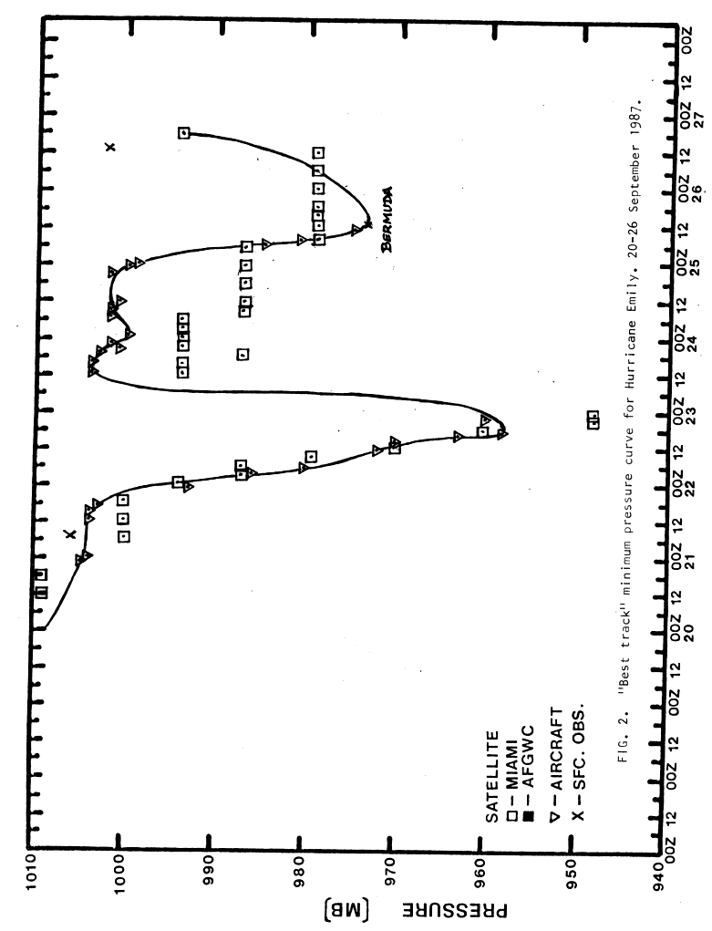
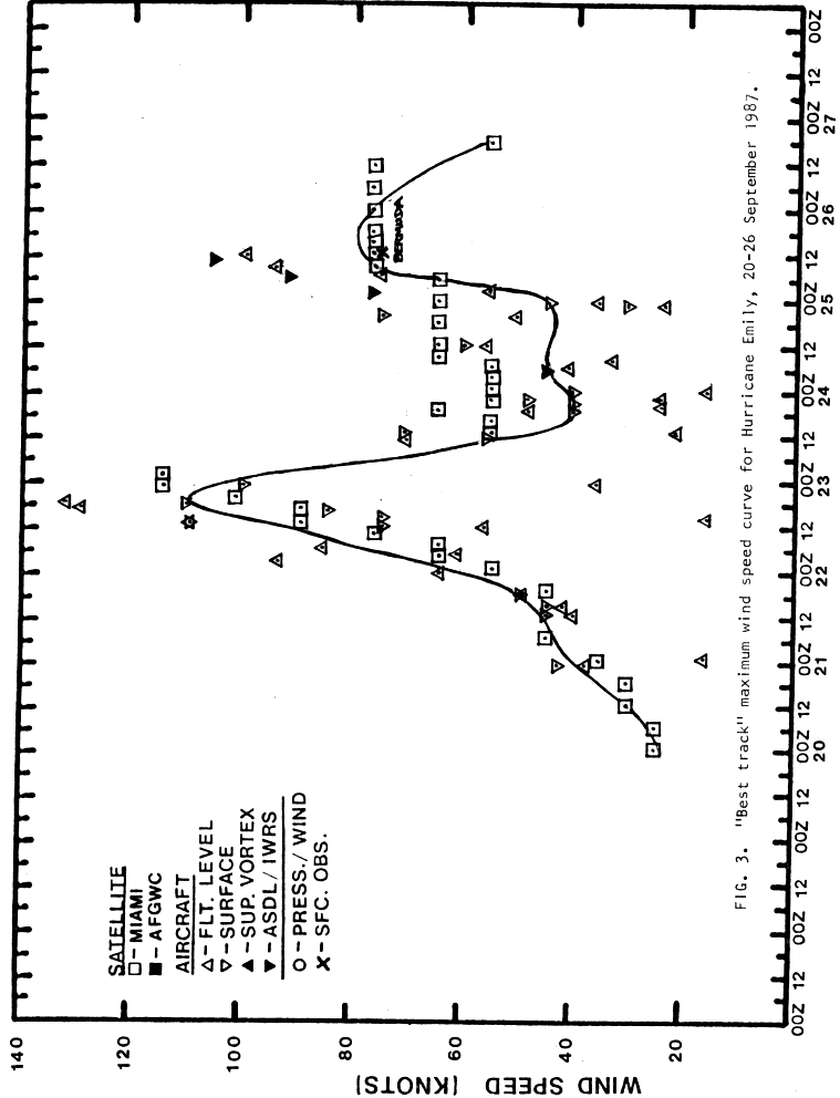
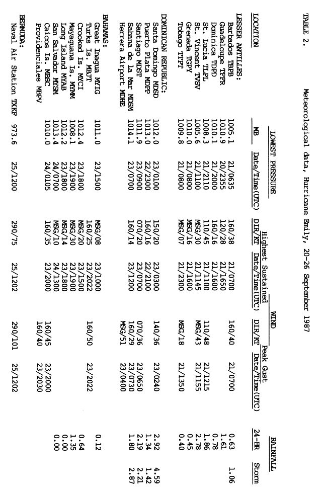
Gradual intensification took place throughout September 20, attaining the status of tropical storm by 1800 UTC and received the name Emily. The storm tracked in a general west-northwest direction around the edge of a strong subtropical ridge. By 1200 UTC on September 21, the center of Emily passed directly over St. Vincent with winds of 50 mph (80 km/h). [1] Situated underneath an anticyclone, rapid intensification took place as the storm quickly tracked towards Hispaniola. In the 24-hour span between 1800 UTC on September 21 and 1800 UTC on September 22, the central barometric pressure of the storm dropped 44 mbar (hPa) to 958  mbar (hPa; 28.29  inHg) and winds increased to 125 mph (201 km/h), equivalent to a high-end Category 3 hurricane on the Saffir–Simpson Hurricane Scale. [2] At the time of peak intensity, the hurricane hunters recorded flight-level winds of 155 mph (249 km/h). [3] [4]

The eye of Hurricane Emily as seen by the Hurricane Hunters during a reconnaissance mission on September 22 Eye of Hurricane Emily 1987.jpg
The eye of Hurricane Emily as seen by the Hurricane Hunters during a reconnaissance mission on September 22

Slight weakening took place late on September 22 and early on September 23 as the hurricane neared landfall. Around 0300 UTC, the eye of Emily tracked onshore between Barahona and Bani, Dominican Republic as a strong Category 2 hurricane with winds of 110 mph (180 km/h). Within 12 hours of landfall, the hurricane weakened to a tropical storm and had emerged into the Atlantic Ocean near Haiti with winds of 65 mph (105 km/h). The storm significantly slowed while tracking through the eastern Bahamas as a quasi-stationary frontal system influenced Emily. Moving generally towards the north, the center of circulation passed very close to Inagua and Mayaguana on September 24. [2]

By midday on September 24, the system became embedded within the mid-latitude westerlies and rapidly accelerated towards the northeast. The National Hurricane Center anticipated that Emily would undergo an extratropical transition within 24 hours at this point as they forecast it to merge with the frontal system to the northeast. However, the storm unexpectedly underwent a second phase of rapid intensification on September 25, at one point reaching the rate of explosive intensification with the central pressure decreasing at 2.5 mbar per hour. By 0600 UTC, Emily had re-attained hurricane intensity and at 1145 UTC, the center passed directly over Bermuda with winds of 85 mph (137 km/h). Soon after, the storm reached its secondary peak intensity with winds of 90 mph (140 km/h) and a minimum pressure of 974 mbar (hPa; 28.76 inHg). [2]

Hurricane Emily continued tracking northeast throughout September 25 into the following day with increasing speed. By late on September 25, the forward motion of the storm had reached 50 mph (80 km/h). The storm now began to undergo an extratropical transition with forward speed peaking at 68 mph (109 km/h), the second-highest forward motion ever recorded in a tropical cyclone. [5] Interacting with a baroclinic zone, the hurricane completed its transition at 1800 UTC on September 26, resulting in the issuance of the final advisory on the storm. [6]

Preparations

Hurricane Emily near Bermuda Hurricane Emily (1987) near Bermuda.JPG
Hurricane Emily near Bermuda

As Tropical Storm Emily quickly approached the Windward Islands on September 21, a tropical storm warning was issued for Grenada, Barbados, St. Vincent and St. Lucia. A tropical storm watch was also declared for Martinique. [7] As the storm tracked through the islands, [1] all watches and warnings were discontinued later that day. [7] Early on September 22, a hurricane warning was issued for the southern coast of the Dominican Republic and southern Haiti, including the southwestern peninsula. [7] Upon attaining major hurricane status, a hurricane warning was declared for northern Haiti as the storm was anticipated to maintain hurricane intensity through landfall. Later that day, a hurricane watch was issued for the southeastern Bahamas and the Turks and Caicos Islands. This watch was later upgraded to a warning as the storm was expected to regain intensity over the Bahamas. [8]

Following the anticipation of a more westerly track on September 23, [2] a hurricane watch was issued for the northwestern Bahamas, later superseded by a warning, and a hurricane warning was declared for eastern Cuba. Early on September 24, all watches and warnings for the Caribbean Islands, including the Bahamas, were discontinued as Emily moved out over the Atlantic Ocean. [2] [8] On September 25, a special advisory was issued for Bermuda as tropical storm-force winds were likely to impact the island. [8] Following the unexpected intensification, [2] another special advisory was issued stating that hurricane-force winds would impact the island during the day on September 25. This advisory was discontinued following the storms' passage later that day. [8]

Throughout the Windward Islands, schools and businesses were closed ahead of the storm. [9] In the Dominican Republic, roughly 6,000 people were evacuated from Santo Domingo ahead of the storm. [10] Although the storm never tracked towards Florida, state officials advised residents to prepare for the storm. [11] Officials were in the "awareness stage" of hurricane preparation as they were discussing the possibility of impact from Emily. [12] In the Turks and Caicos, residents were evacuated from low-lying areas to shelters throughout the islands. [13]

On September 25, the Canadian Hurricane Centre issued its first information bulletin ever related to a tropical cyclone as Emily was moving into Canadian offshore waters. The agency was created less than a month earlier, and warned for the potential of heavy rainfall and strong winds in the ocean southeast of Newfoundland. [14] [15]

Impact and aftermath

Rainfall totals from Hurricane Emily in Puerto Rico Emily 1987 rainfall.png
Rainfall totals from Hurricane Emily in Puerto Rico

Tracking through the Lesser Antilles as a tropical storm, Emily brought heavy rains to several islands. In Barbados, high winds caused widespread roof damage and downed trees and power lines; losses on the island reached $100,000. [9] [16] On St. Vincent, the banana industry sustained severe losses, with roughly 70% of the crop destroyed. [16] [17] Schools throughout the island were closed prior and during the storm. [18] Up to 3 in (76 mm) of rain fell within six hours on the island, [16] causing flooding that forced eight families to evacuate their homes. [9] Damage on the island amounted to $191,000, mainly from landslides. [19] The outer bands of Emily produced moderate rainfall across portions of southwest Puerto Rico, peaking at 4.63 in (118 mm). [20]

In the Dominican Republic, Emily's heavy rains caused widespread mudslides, killing two people. [16] Another person was killed after stepping on a downed power line. [21] An estimated 5,000 people were left homeless in the aftermath of the storm. [22] Upwards of 4.59 in (117 mm) of rain fell during the storm in the Dominican Republic. [23] The farming industry was impacted particularly hard, with $30 million in losses occurring. [22] Following the storm, hundreds of volunteers in the Dominican Republic assisted evacuees in shelters and helped officials clean up the affected areas. The Red Cross was also deployed to the region to assist those left homeless by the storm. [21] In all, Emily caused $80.3 million in damage and killed three people. [16] [22]

Although Emily passed over Haiti, it produced little damage and no loss of life. The lack of fatalities was linked to the amount of forest remaining over the mountains of the country, estimated at 25% of their original size, compared to the 1.4% remaining in 2004. [24] In the Bahamas, Emily produced winds up to 60 mph (97 km/h) along with rainfall up to 1.35 in (34 mm). [23]

A typical Bermudian roof made up of heavy limestone slates Bermuda roof.jpg
A typical Bermudian roof made up of heavy limestone slates

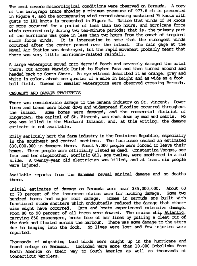
The storm was not expected to be strong when it passed Bermuda. Worse still, most Bermudians were unaware the storm had accelerated and covered a considerable distance overnight, and with no obvious signs of the imminence of its arrival, set off to work or school without making any preparations to protect their homes. Similarly to the 1926 Havana–Bermuda hurricane, the islanders were caught completely off guard by the 90 mph (140 km/h) winds. Cars and boats were affected the most. Wooden accommodation blocks on the United States Naval Air Station Bermuda were destroyed, but the tough building standards and the heavy masonry or concrete construction of buildings outside of the US bases meant that only a small number of houses experienced severe damage during the storm's passage. Bermudian roofs are constructed from heavy limestone slates. Bermudian houses are generally windproof, but are vulnerable to roof damage when the outside air pressure drops in the eye of a cyclonic storm and the expanding air inside a sealed house lifts the roof. The heavy limestone roofs are not easily moved, and are designed to shed slates, opening only a small breach instead of losing the entire roof. As a hurricane approaches, Bermudians close windows and storm shutters on the windward side but leave the leeward side windows open, allowing interior air pressure to rapidly equalise with the exterior without damage to the roof. As Bermudians would normally stay at home during a hurricane, once the storm centre had passed over, they would open the previously windward windows and close those on the opposite side (there is also a considerable difference in exterior air pressure between the windward and leeward sides of a house during a storm). As few were at home when the storm struck, and most had left all of their windows closed and locked, a great many homes suffered minor roof damage in the form of lost slates. This caused considerable difficulty as there were not enough roofers and not enough ready slate to quickly repair the damage, and also not enough tarpaulins either already in possession of home owners are in stock at hardware stores and supplies had to be specially flown in. Hurricane Emily, which Bermudians dubbed "The B****h that came to breakfast", caused $50 million in damage to the island, though no one was killed. About 230 buildings lost their roofs and 16 people were injured due to winds gusting in excess of 112 mph (180 km/h). The United States Naval Air Station Bermuda, where buildings were not constructed to local standards, suffered the greatest damage. An air show had to be cancelled and the Blue Angels flight demonstration squadron evacuated, though their Lockheed C-130 Hercules had to be left behind, sheltering in a hangar in which it did not quite fit. The Civil Air Terminal at the air station lost a large portion of its roof during the storm. Several cars and boats were flipped by the storm and a cruise ship carrying 700 people slipped from its moorings. [25] [26] [27] [28] Before the storm's landfall, officials in Bermuda cut power to roughly 90% of the island to protect the power grid. [29] There were also unconfirmed reports of tornadoes associated with the storm. Emily was the strongest hurricane to hit Bermuda since the 1948 season. [16]

See also

Related Research Articles

<span class="mw-page-title-main">Hurricane Hortense</span> Category 4 Atlantic hurricane in 1996

Hurricane Hortense was the first tropical cyclone to make landfall in Guadeloupe and Puerto Rico since Hurricane Hugo in 1989, and the second most intense hurricane during the 1996 Atlantic hurricane season. The eighth tropical cyclone, eighth named storm, and sixth hurricane of the season. Hortense developed on September 3 from a tropical wave in the central Atlantic Ocean. Initially a tropical depression, it headed westward without significant strengthening for four days due to unfavorable upper-level winds. While nearing the Lesser Antilles upper-level winds decreased, allowing the depression to become Tropical Storm Hortense on September 7. Hortense crossed Guadeloupe on September 8 and entered the Caribbean Sea. By on the following day, it was upgraded to a hurricane while curving northwestward. Hortense made landfall in Puerto Rico on September 9 and brushed the Dominican Republic shortly thereafter. After re-entering the Atlantic, Hortense began to substantially strengthen and peaked as a 140 mph (220 km/h) Category 4 hurricane early on September 13. Thereafter, the storm steadily weakened as it tracked rapidly north-northeastward. Early on September 15, Hortense made landfall in Nova Scotia as a minimal Category 1 hurricane. It quickly weakened further to a tropical storm before re-entering the Atlantic to the south of Newfoundland. Late on September 15, Hortense transitioned into an extratropical cyclone and subsequently merged with a frontal system about 24 hours later.

<span class="mw-page-title-main">1992 Atlantic hurricane season</span> Hurricane season in the Atlantic Ocean

The 1992 Atlantic hurricane season was a significantly below average season in which only ten tropical or subtropical cyclones formed. Six became named tropical storms, of which four became hurricanes. Among the four was Hurricane Andrew, a major hurricane, and the costliest Atlantic hurricane on record at the time, surpassing Hugo of 1989. The season officially started on June 1 and officially ended on November 30. However, tropical cyclogenesis is possible at any time of the year, as demonstrated by formation in April of an unnamed subtropical storm in the central Atlantic. A June tropical depression caused flooding in Cuba and in Florida, where two people were killed. In August, Andrew struck the Bahamas, Florida, and Louisiana. In all, it caused $27.3 billion in damage, mostly in Florida, as well as 65 fatalities. The greatest impact was in South Florida, where the storm made landfall with 1-minute sustained winds of 175 mph (280 km/h).

<span class="mw-page-title-main">1981 Atlantic hurricane season</span> Hurricane season in the Atlantic Ocean

The 1981 Atlantic hurricane season featured direct or indirect impacts from nearly all of its 12 tropical or subtropical storms. Overall, the season was fairly active, with 22 tropical depressions, 12 of which became a namable storm, while 7 of those reached hurricane status and 3 intensified into major hurricanes. The season officially began on June 1, 1981, and lasted until November 30, 1981. These dates conventionally delimit the period of each year when most tropical cyclones form in the Atlantic basin. However, tropical cyclogenesis can occur before these dates, as demonstrated with the development of two tropical depressions in April and Tropical Storm Arlene in May. At least one tropical cyclone formed in each month between April and November, with the final system, Subtropical Storm Three, becoming extratropical on November 17, 1981.

<span class="mw-page-title-main">1983 Atlantic hurricane season</span> Hurricane season in the Atlantic Ocean

The 1983 Atlantic hurricane season was the least active Atlantic hurricane season since 1930. The season officially began on June 1, 1983, and lasted until November 30, 1983. These dates conventionally delimit the period of each year when most storms form in the Atlantic basin. The season had very little activity, with only seven tropical depressions, four of which reached tropical storm strength or higher. This led to the lowest accumulated cyclone energy count since 1977, but not since 1914.

<span class="mw-page-title-main">1984 Atlantic hurricane season</span> Hurricane season in the Atlantic Ocean

The 1984 Atlantic hurricane season was the most active since 1971, though the season was below average in hurricanes and major hurricanes. It officially began on June 1, 1984, and lasted until November 30, 1984. These dates conventionally delimit the period of each year when most tropical cyclones form in the Atlantic basin. The 1984 season was an active one in terms of named storms, but most of them were weak and stayed at sea. Most of the cyclones tracked through the northwest subtropical Atlantic west of the 50th meridian to near the Eastern coast of the United States between mid-August and early October. The most damaging storm was Hurricane Klaus, which caused $152 million (1984 dollars) in damage in Puerto Rico. Hurricane Diana was the first hurricane to strike a nuclear power plant without incident; it was also the first major hurricane to strike the U.S. East Coast in nearly 20 years. Also of note was Hurricane Lili, which lasted well after the official end of the season. It was downgraded from a named storm on December 24. Damage overall from the tropical cyclones in 1984 totaled $228.7 million. Unusually, no hurricanes developed from tropical waves in 1984, which usually are the source of the strongest storms in an Atlantic hurricane season.

<span class="mw-page-title-main">1989 Atlantic hurricane season</span> Hurricane season in the Atlantic Ocean

The 1989 Atlantic hurricane season was an average hurricane season with 11 named storms. The season officially began on June 1, and ended on November 30. The first tropical cyclone, Tropical Depression One, developed on June 15, and dissipated two days later without any effects on land. Later that month, Tropical Storm Allison caused severe flooding, especially in Texas and Louisiana. Tropical Storm Barry, Tropical Depressions Six, Nine, and Thirteen, and Hurricanes Erin and Felix caused negligible impact. Hurricane Gabrielle and Tropical Storm Iris caused light effects on land, with the former resulting in nine fatalities from rip currents offshore the East Coast of the United States and Atlantic Canada, while the latter produced minor flooding in the United States Virgin Islands.

<span class="mw-page-title-main">1990 Atlantic hurricane season</span> Hurricane season in the Atlantic Ocean

The 1990 Atlantic hurricane season was the most active Atlantic hurricane season since 1969, with a total of 14 named storms. The season also featured eight hurricanes, one of which intensified into a major hurricane. It officially began on June 1, 1990, and lasted until November 30, 1990. These dates conventionally delimit the period of each year when most tropical cyclones form in the Atlantic basin. However, tropical cyclogenesis can occur prior to the start of the season, as demonstrated with Tropical Depression One, which formed in the Caribbean Sea on May 24.

<span class="mw-page-title-main">Hurricane Joan–Miriam</span> Category 4 Atlantic and Pacific hurricane in 1988

Hurricane Joan was a long lived and powerful tropical cyclone that caused death and destruction in over a dozen countries in the Caribbean and Central America. Moving on a due west course for nearly two weeks in October 1988, Hurricane Joan caused widespread flooding and over 200 deaths after moving into Central America. Widespread suffering and economic crises were exacerbated by Joan, primarily across Nicaragua, as heavy rains and high winds impacted those near the hurricane's path.

<span class="mw-page-title-main">Hurricane Diana (1984)</span> Category 4 Atlantic hurricane in 1984

Hurricane Diana was the first major hurricane to hit the East Coast of the United States in nearly 20 years. Diana was the ninth tropical cyclone, fourth named storm, first hurricane, and first major hurricane of the 1984 Atlantic hurricane season. It caused moderate damage in North Carolina while it looped offshore and after it made landfall as a Category 2 hurricane. Forming on September 8, Diana moved northward and wandered across North Carolina for a couple of days during mid-September, dropping heavy rainfall. Once it left the state and accelerated east-northeast, Diana quickly evolved into an extratropical cyclone. Watches and warnings were issued for the storm along the East coast between eastern Florida and Virginia. Damages to the United States totaled $65.5 million. Three indirect fatalities were caused by the cyclone.

<span class="mw-page-title-main">Hurricane Chantal (1989)</span> Category 1 Atlantic hurricane in 1989

Hurricane Chantal was one of three tropical cyclones to make landfall in Texas during the 1989 Atlantic hurricane season. The third named storm and the first hurricane of the season, Chantal slowly developed on July 30 in the southern Gulf of Mexico from a tropical disturbance that was previously within Intertropical Convergence Zone (ITCZ) while near Trinidad and Tobago. While heading north-northwestward, the depression steadily intensified and was upgraded to Tropical Storm Chantal on the following day. Thereafter, Chantal quickly strengthen and became a hurricane on August 1. After intensifying slightly further, Chantal made landfall near High Island, Texas later that day. The storm quickly weakened upon moving inland and fell to tropical storm intensity a few hours after landfall. Early on August 2, Chantal weakened to a tropical depression and dissipated over Oklahoma by August 4.

<span class="mw-page-title-main">1987 Atlantic hurricane season</span> Hurricane season in the Atlantic Ocean

The 1987 Atlantic hurricane season was a below-average hurricane season that was limited by an ongoing El Niño. The season officially began on June 1, 1987, and lasted until November 30, 1987, although activity began on May 24 when a tropical depression developed 400 mi (640 km) east of the central Bahamas. The June through November dates conventionally delimit the period of each year when most tropical cyclones form in the Atlantic basin. The first cyclone to attain tropical storm status was an unnamed tropical storm which formed on August 9, nearly a month later than usual. The final storm of the year, Tropical Depression Fourteen, merged with a weak extratropical low on November 4. The season marked the first year tropical storm watches and warnings were issued; previously, gale watches and warnings were used for tropical storms, and this season was one of only a few seasons with no deaths in the United States; the last time this happened was in the 1981 season.

<span class="mw-page-title-main">Hurricane Bertha (1990)</span> Category 1 Atlantic hurricane in 1990

Hurricane Bertha caused minor damage in the United States, Bermuda, and Atlantic Canada in July and August 1990. The third tropical cyclone, second named storm, and first hurricane of the 1990 Atlantic hurricane season, Bertha developed from a frontal low pressure area offshore of North Carolina on July 24. Initially subtropical, it slowly acquired tropical characteristics while tracked southeast and then southwestward. By early on July 27, the cyclone was re-classified as a tropical depression. Following its transition, the depression intensified and was upgraded to Tropical Storm Bertha on July 28. The storm then curved northeastward and rapidly strengthened. Bertha became a hurricane early on July 29, though it weakened back to a tropical storm later that day. On the following day, Bertha re-intensified into a hurricane and peaked as an 80 mph (130 km/h) Category 1 hurricane on July 31.

<span class="mw-page-title-main">Hurricane Arlene (1987)</span> Category 1 Atlantic hurricane in 1987

Hurricane Arlene was a long-lived tropical cyclone that moved eastward in an erratic fashion in the northern Atlantic Ocean in mid-August 1987. The first named storm of the 1987 Atlantic hurricane season, Arlene formed out of an area of low pressure associated with a decaying frontal system along the North Carolina coastline, Arlene tracked in a general eastward direction across the Atlantic Ocean, taking an erratic track with several curves. On August 13, the storm brushed Bermuda as a weak tropical storm before continuing out to sea. On August 20, the storm briefly stalled before becoming a hurricane two days later. Early on August 24, the storm transitioned into an extratropical cyclone over the far north Atlantic before curving southeast and dissipating near the Iberian Peninsula on August 26.

<span class="mw-page-title-main">Tropical Storm Isidore (1984)</span> Atlantic tropical storm in 1984

Tropical Storm Isidore was a relatively weak tropical cyclone that passed over most of the Florida Peninsula in late September 1984. The fifteenth tropical cyclone and 9th named storm of the 1984 Atlantic hurricane season. Isidore formed as a tropical depression on September 25, while situated off the southeastern Bahamas. The depression headed west, and was upgraded to a tropical storm in the central Bahamas the next day. It made landfall near Jupiter, Florida, and retaining tropical storm strength, Isidore curved to the northeast, emerging over water near Jacksonville, Florida. Isidore continued northeast until it was absorbed by a frontal system on October 1. Though damage was generally light, the storm affected several regions from the Bahamas to the U.S. East Coast. One death was reported in Florida, and total damage is estimated at $1 million.

<span class="mw-page-title-main">Hurricane Dalilia</span> Third hurricane of the 1989 Pacific hurricane season

Hurricane Dalilia was the only tropical cyclone during 1989 to affect the Hawaiian Islands. A tropical disturbance developed into a tropical depression on July 11 and into Hurricane Dalilia on July 13. Dalilia crossed 140°W shortly after reaching its maximum intensity and entered the Central Pacific Hurricane Center's area of responsibility. The storm accelerated, and headed directly towards the Hawaiian Islands. Hurricane Dalilia passed just south of the Hawaiian Islands as a tropical storm before dissipating July 21 as it interacted with a trough. It then interacted with the remains of Tropical Storm Erick and reformed into a depression on July 24. A trough then accelerated the remnants towards the Aleutian Islands on July 28. The cyclone's effects were minimal. There was high surf, and some gusty winds. Damage was minor, and mainly limited to downed power lines. However, many areas throughout the island chain received more than 5 in (130 mm) of precipitation.

<span class="mw-page-title-main">Hurricane Gustav (1990)</span> Category 3 Atlantic hurricane in 1990

Hurricane Gustav was the only major hurricane that formed during the 1990 Atlantic hurricane season. Developing out of a tropical wave on August 24, Gustav tracked westward across the Atlantic Ocean, steadily intensifying. The storm reached hurricane-status on August 26 and reached its initial peak intensity as a strong Category 2 hurricane the following day. After turning towards the north and weakening due to increased wind shear, the storm encountered more favorable conditions and re-intensified, attaining peak winds of 120 mph (190 km/h) around 0600 UTC on August 31. Gradual weakening took place in the following days. on September 2, the former hurricane underwent an extratropical transition and dissipated shortly after completing it. At that time, the system was located roughly 230 miles (370 km) south of Iceland.

<span class="mw-page-title-main">Timeline of the 1987 Atlantic hurricane season</span>

The 1987 Atlantic hurricane season was an event in the annual Atlantic hurricane season in the north Atlantic Ocean. It was a below-average season, having fewer named storms than in a normal year, that resulted in little impact throughout the Atlantic basin; the United States recorded no hurricane-related fatalities, making the 1987 season the fourth to do so since 1976. The season officially began on June 1, 1987 and ended November 30, 1987. These dates, adopted by convention, historically describe the period in each year when most systems form. Even so, a pre-season storm, Tropical Depression One, led to the season's starting on May 25. Storm activity ended several weeks early; the final storm of the season, Tropical Depression Fourteen, dissipated on November 4.

<span class="mw-page-title-main">Hurricane Arlene (1963)</span> Category 2 Atlantic hurricane in 1963

Hurricane Arlene was the first tropical cyclone of the 1963 Atlantic hurricane season and one of the wettest storms ever recorded in Bermuda. Originating from a tropical depression on July 31, Arlene quickly intensified into a Category 2 hurricane on August 2. After attaining this intensity, the storm quickly weakened and turned west. By August 4, Arlene had degenerated into a tropical depression. The storm failed to re-organize until August 7, by which time it restrengthened into a tropical storm. The following day, Arlene re-attained hurricane-status before passing directly over Bermuda. Several hours after passing the island, it reached its peak intensity with winds of 115 mph (160 km/) and a barometric pressure of 969 mbar. By August 11, Arlene transitioned into an extratropical cyclone before being absorbed by another cyclone later that day.

<span class="mw-page-title-main">Hurricane Grace (1991)</span> Category 2 Atlantic hurricane in 1991

Hurricane Grace was a short-lived Category 2 hurricane that contributed to the formation of the powerful 1991 Perfect Storm. Forming on October 26, Grace initially had subtropical origins, meaning it was partially tropical and partially extratropical in nature. It became a tropical cyclone on October 27, and ultimately peaked with winds of 105 mph (165 km/h). The storm had minor effects on the island of Bermuda as it passed to the south. A developing extratropical storm to the north turned Grace eastward; the hurricane was eventually absorbed into the large circulation of the larger low-pressure system. Fed by the contrast between cold air to the northwest and warm air from the remnants of Grace, this storm became a large and powerful Nor'easter that caused extremely high waves and resulted in severe coastal damage along the East Coast of the United States.

References

  1. 1 2 3 Harold P. Gerrish (November 12, 1987). "Hurricane Emily Preliminary Report: Page One". National Hurricane Center. Retrieved July 2, 2009.
  2. 1 2 3 4 5 6 Harold P. Gerrish (November 12, 1987). "Hurricane Emily Preliminary Report: Page Two". National Hurricane Center. Retrieved July 2, 2009.
  3. Harold P. Gerrish (November 12, 1987). "Hurricane Emily Preliminary Report: Page Nineteen". National Hurricane Center. Retrieved July 3, 2009.
  4. Harold P. Gerrish (November 12, 1987). "Hurricane Emily Preliminary Report: Page Twenty". National Hurricane Center. Retrieved July 3, 2009.
  5. "What is the average forward speed of a hurricane?". Hurricane Research Division. Retrieved 14 November 2017.
  6. Harold P. Gerrish (November 12, 1987). "Hurricane Emily Preliminary Report: Page Three". National Hurricane Center. Retrieved July 2, 2009.
  7. 1 2 3 Harold P. Gerrish (November 12, 1987). "Hurricane Emily Preliminary Report: Page Nine". National Hurricane Center. Retrieved July 3, 2009.
  8. 1 2 3 4 Harold P. Gerrish (November 12, 1987). "Hurricane Emily Preliminary Report: Page Ten". National Hurricane Center. Retrieved July 3, 2009.
  9. 1 2 3 "Hurricane Emily strengthening". The Free-Lance Star. Associated Press. September 22, 1987. Retrieved July 3, 2009.
  10. "Hurricane Emily kills 3 in Caribbean". Pittsburgh Post-Gazette. Associated Press. September 24, 1987. Retrieved July 3, 2009.
  11. Dexter Filkins; Carlos Harrison (September 23, 1987). "County yawns at Hurricane Emily; Officials prepare for possible disaster". Miami Herald. p. 4PB. Retrieved June 10, 2021 via Newspapers.com. Lock-green.svg
  12. Lori Rozsa (September 23, 1987). "Emily brings hurricanes to mind". Miami Herald. p. 1B. Retrieved June 10, 2021 via Newspapers.com. Lock-green.svg
  13. A. J. Dickerson (September 24, 1987). "Hurricane warning lifted as Emily weakens". The Free-Lance Star. Retrieved July 3, 2009.
  14. Canadian Hurricane Centre (2009-07-15). History of the Canadian Hurricane Centre (CHC) (Report). Environment Canada . Retrieved 2013-08-08.
  15. RWH (September 25, 1987). Canadian Hurricane Prognostic Message Issued By Environment Canada at 0830 PM ADT Friday 25 September 1987 (TXT) (Report). Canadian Hurricane Centre. Retrieved August 8, 2013.
  16. 1 2 3 4 5 6 Robert A. Case and Harold P. Gerrish (April 1988). "Atlantic Hurricane Season of 1987" (PDF). National Hurricane Center. Retrieved July 1, 2009.
  17. Department of Public Affairs (November 1994). "St. Vincent and the Grenadines". United States Department of State. Archived from the original on March 3, 2016. Retrieved July 1, 2009.
  18. "Hurricane Emily Strengthens, Posing Threat to Hispaniola". The New York Times. Associated Press. September 22, 1987. Retrieved July 1, 2009.
  19. Nicholas DeGraff (August 25, 1999). "Natural Hazards and Disasters: Landslides in St. Lucia". University of California, Santa Cruz. Archived from the original on March 9, 2016. Retrieved July 1, 2009.
  20. David M. Roth (2009). "Hurricane Emily - September 21–23, 1987". Hydrometeorological Prediction Center. Retrieved July 2, 2009.
  21. 1 2 "Emily regaining strength after hitting Dominican". The Bulletin. United Press International. September 23, 1987. Retrieved July 3, 2009.
  22. 1 2 3 Harold P. Gerrish (November 12, 1987). "Hurricane Emily Preliminary Report: Page 4". National Hurricane Center. Retrieved July 1, 2009.
  23. 1 2 Harold P. Gerrish (November 12, 1987). "Hurricane Emily Preliminary Report: Page Eight". National Hurricane Center. Retrieved July 2, 2009.
  24. Jane Deren (2008). "Hurricanes and Haiti: A Tragic History" (PDF). Saint Bridget Church. Archived from the original (PDF) on July 27, 2011. Retrieved July 1, 2009.
  25. Fry Brewe, Jacki. "Jacki Fry Brewer, PRCS - Military Timeline: 1987-1990 NAS Bermuda". navy.togetherweserved.com. togetherweserved.com Inc. Retrieved 2023-04-03. I was stationed in Bermuda when we were suppose to have a Blue Angel airshow but Hurricane Emily decided she wanted first bill so the jets had to fly out but Fat Albert (the C130) didn't have time to depart as we got little warning she was coming. (Emily took an unexpected turn toward the island during the wee hours one Sept morning.) I was safety officer at the time so I had to report to my post after I got CJ situated in a safe place with friends. Our hangars weren't designed to hold and tie down C130s so we towed Fat Albert in as far as we could and put as many people in the cockpit as possible to hold the nose down. The strongest winds hit. The tail of the plane was sticking outside of the hangar and was being pushed side ways and up and down. I stood in front of Fat Albert to observe any further dangerous situations (HA) and watched as the nose of the plane which was inside the hangar bounce up and down like a basketball. This was about 9 or 10 am. That day was known as the morning the bitch came to breakfast. Oh, yes, and Emily took the roof off my apartment on base and caved in all the ceilings. She was such a lady.
  26. "Remembering Hurricane Emily". The Royal Gazette. City of Hamilton, Pembroke Parish, Bermuda: The Royal Gazette. 2011-06-15. Retrieved 2021-12-04.
  27. "Hurricane in Bermuda Causes Minor Injuries". The New York Times. Associated Press. September 26, 1987.
  28. Staff Writer (September 26, 1987). "Hurricane Emily Buffets Bermuda". The Washington Post. Archived from the original on October 25, 2012. Retrieved July 1, 2009.
  29. "Hurricane injures 16 in Bermuda". The Boston Globe. Associated Press. September 26, 1987. Archived from the original on October 25, 2012. Retrieved July 1, 2009.
Hurricane Emily
Emily 1987-09-22 1900Z.jpg
Emily at peak intensity near landfall on the island of Hispaniola on September 22