Related Research Articles
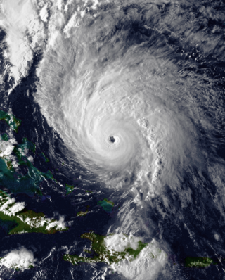
Hurricane Hortense was the first tropical cyclone to make landfall in Guadeloupe and Puerto Rico since Hurricane Hugo in 1989, and the second most intense hurricane during the 1996 Atlantic hurricane season. The eighth tropical cyclone, eighth named storm, and sixth hurricane of the season, Hortense developed on September 3 from a tropical wave in the central Atlantic Ocean. Initially a tropical depression, it headed westward without significant strengthening for four days due to unfavorable upper-level winds. While nearing the Lesser Antilles upper-level winds decreased, allowing the depression to become Tropical Storm Hortense on September 7. Hortense crossed Guadeloupe on September 8 and entered the Caribbean Sea. By on the following day, it was upgraded to a hurricane while curving northwestward. Hortense made landfall in Puerto Rico on September 9 and brushed the Dominican Republic shortly thereafter. After re-entering the Atlantic, Hortense began to substantially strengthen and peaked as a 140 mph (220 km/h) Category 4 hurricane early on September 13. Thereafter, the storm steadily weakened as it tracked rapidly north-northeastward. Early on September 15, Hortense made landfall in Nova Scotia as a minimal Category 1 hurricane. It quickly weakened further to a tropical storm before re-entering the Atlantic to the south of Newfoundland. Late on September 15, Hortense transitioned into an extratropical cyclone and subsequently merged with a frontal system about 24 hours later.

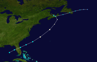
Hurricane Juan was a significant tropical cyclone which caused extensive damage to parts of Atlantic Canada, being the tenth named storm and the sixth hurricane of the 2003 Atlantic hurricane season. Juan formed southeast of Bermuda on September 24 from a tropical wave that had tracked across the subtropical Atlantic Ocean. It tracked northward and strengthened over the warm waters of the Gulf Stream, reaching Category 2 strength on the Saffir-Simpson hurricane scale on September 27. The hurricane peaked in intensity with sustained winds of 105 mph (169 km/h) that same day, losing some strength as it raced over cooler waters toward the coast of Nova Scotia, before making landfall between Shad Bay and Prospect in the Halifax Regional Municipality early on September 29 as a Category 2 hurricane with winds of 100 mph (160 km/h). Juan retained hurricane strength while travelling through Nova Scotia, though it would weaken into a Category 1 hurricane over Prince Edward Island. Juan would eventually be absorbed by another extratropical low on September 29 near Anticosti Island in the northern Gulf of Saint Lawrence.
The 1959 Escuminac disaster, also known as the Escuminac hurricane, was considered the worst fishing-related disaster in New Brunswick in 100 years. It occurred due to the extratropical remnants of an Atlantic hurricane. The storm was the third tropical cyclone and first hurricane of the 1959 Atlantic hurricane season, and developed from a tropical wave in the central Gulf of Mexico on June 18. It headed rapidly northeastward and struck Florida later that day. Shortly after entering the Atlantic Ocean, it strengthened into a tropical storm later on June 18. By the following day, it had strengthened into a hurricane. However, it transitioned into an extratropical cyclone about six hours later. The remnants struck Atlantic Canada, once in Nova Scotia and again in Newfoundland before dissipating on June 21.

The 1937 Atlantic hurricane season was a below-average hurricane season, featuring eleven tropical storms; of these, four became hurricanes. One hurricane reached major hurricane intensity, equivalent to a Category 3 or higher on the modern Saffir–Simpson scale. The United States Weather Bureau defined the season as officially lasting from June 16 to October 16. Tropical cyclones that did not approach populated areas or shipping lanes, especially if they were relatively weak and of short duration, may have remained undetected. Because technologies such as satellite monitoring were not available until the 1960s, historical data on tropical cyclones from this period are often not reliable. As a result of a reanalysis project which analyzed the season in 2012, a tropical storm and a hurricane were added to the Atlantic hurricane database (HURDAT). The official intensities and tracks of all storms were also revised by the reanalysis. The year's first storm formed on July 29 in the Gulf of Mexico, and the final system, a hurricane, dissipated over open ocean on October 21.
The 1927 Atlantic hurricane season was a relatively inactive season, with eight tropical storms, four of which became hurricanes. One of these became a major hurricane – Category 3 or higher on the modern day Saffir–Simpson scale. The first system, a tropical depression, developed on August 13, while the final cyclone, a tropical storm, merged with a cold front on November 21. No hurricane made landfall in the United States, in contrast to the four that struck the U.S. in the previous season.

The 1991 Perfect Storm, also known as The No-Name Storm and the Halloween Gale/Storm, was a damaging and deadly nor'easter in October 1991. Initially an extratropical cyclone, the storm absorbed Hurricane Grace to its south and evolved into a small unnamed hurricane later in its life. Damage from the storm totaled over $200 million and thirteen people were killed in total, six of which were an outcome of the sinking of Andrea Gail, which inspired the book and later movie, The Perfect Storm. The nor'easter received the name, playing off the common expression, after a conversation between Boston National Weather Service forecaster Robert Case and author Sebastian Junger.
Hurricane Helene was the most intense tropical cyclone of the 1958 Atlantic hurricane season. The eighth tropical storm and fourth hurricane of the year, Helene was formed from a tropical wave east of the Lesser Antilles. Moving steadily westward, the storm slowly intensified, attaining hurricane strength on September 26. As conditions became increasingly favorable for tropical cyclone development, Helene began to rapidly intensify. Nearing the United States East Coast, the hurricane quickly attained Category 4 intensity on September 26, before it subsequently reached its peak intensity with maximum sustained winds of 150 mph (240 km/h) and a minimum barometric pressure of 930 mbar. The intense hurricane came within 10 mi (16 km) of Cape Fear, North Carolina before recurving out to sea. Accelerating Helene gradually weakened, and transitioned into an extratropical cyclone as it passed over Newfoundland on September 29. Helene's extratropical remnants traversed eastwards across the Atlantic Ocean before dissipating near Great Britain on October 4.

Tropical Storm Alberto was the first tropical storm of the 2006 Atlantic hurricane season. Forming on June 10 in the northwestern Caribbean, the storm moved generally to the north, reaching a maximum intensity of 70 mph (110 km/h) before weakening and moving ashore in the Big Bend area of Florida on June 13. Alberto then moved through eastern Georgia, North Carolina, and Virginia as a tropical depression before becoming extratropical on June 14.

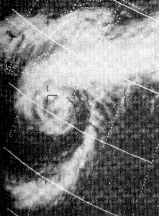
The 1927 Nova Scotia hurricane was the deadliest tropical cyclone striking Canada in the 20th century. The first observed storm of the season, this cyclone developed from a tropical wave over the deep tropics of the Atlantic Ocean on August 18. Initially a tropical storm, it moved west-northwestward and intensified into a Category 1 hurricane on the modern day Saffir–Simpson hurricane wind scale by August 19. The storm intensified significantly over the next few days, and by August 22, it peaked as a Category 3 hurricane with maximum sustained winds of 125 mph (205 km/h). Around that time, the system began curving northwestward and later northward. By August 23, it turned to the north-northeast and then began weakening on August 24. Thereafter, the storm accelerated toward Atlantic Canada. Late on August 24, the hurricane struck near Yarmouth, Nova Scotia, as a Category 2 hurricane, just before becoming extratropical.

Hurricane Karen was a hurricane of non-tropical origin that formed in October of the 2001 Atlantic hurricane season. It developed out of the interaction between a cold front and an upper level trough on October 10 located to the south of Bermuda, and quickly strengthened as an extratropical storm. The storm passed near Bermuda on October 12, producing hurricane-force winds on the island. It then organized, becoming a subtropical cyclone on October 12 and a tropical cyclone on October 13. Karen strengthened to reach 80 mph (130 km/h) winds as a Category 1 hurricane on the Saffir-Simpson Hurricane Scale, and after weakening over cooler waters, it made landfall on Nova Scotia as a tropical storm. It quickly became extratropical.

Hurricane Michael of the 2000 Atlantic hurricane season caused widespread, but relatively minor damage in Atlantic Canada. The seventeenth tropical cyclone, thirteenth named storm, and eighth hurricane of the season, Michael developed from a non-tropical system to the southwest of Bermuda on October 15. The system was initially subtropical, but rapidly acquired tropical characteristics by October 17. Michael quickly strengthened into a hurricane later that day. By October 20, Michael peaked as a Category 2 hurricane on the Saffir-Simpson hurricane wind scale at a relatively high latitude of 44°N. The storm weakened slightly to a Category 1 hurricane and became extratropical shortly before making landfall in Newfoundland on October 20.
The November 2001 Atlantic Canada storm complex was a powerful coastal storm that included the remnants of North Atlantic hurricanes Michelle and Noel. The low intensified as it moved westward into Atlantic Canada on November 6, reaching a minimum pressure of 946 hPa (27.9 inHg). The storm turned to the northeast and emerged into the Atlantic Ocean on November 8. It produced strong winds throughout Atlantic Canada, including gusts of up to 154 km/h (96 mph) at the Confederation Bridge in Prince Edward Island. High waves caused damage along the coastlines, while high winds left up to 100,000 without power. Overall damage was minor, and no casualties were reported.

Tropical Storm Chantal was a short-lived tropical storm that affected Bermuda in its formative stages and caused flooding and gusty winds in Newfoundland while extratropical. The third named storm of the 2007 Atlantic hurricane season, Chantal developed on July 31 from non-tropical origins between Bermuda and Cape Cod, and with favorable conditions, the storm rapidly attained peak winds of 50 mph (80 km/h). The storm accelerated northeastward over an area of progressively colder water temperatures, and after a decrease in convection the National Hurricane Center ceased issuing advisories as Chantal began undergoing extratropical transition early on August 1. Shortly thereafter, the extratropical remnant crossed over southeastern Newfoundland before tracking into the open waters of the north Atlantic Ocean. Prior to forming, the storm dropped moderate rainfall on Bermuda. Subsequent to becoming extratropical, the remnants of Chantal produced gusty winds and heavy precipitation across the Avalon Peninsula of Newfoundland, causing flooding and wind damage; insured damage totaled $25 million.

The 1924 Atlantic hurricane season featured the first officially recorded Category 5 hurricane, a tropical cyclone with maximum sustained winds exceeding 155 mph (249 km/h) on the modern-day Saffir–Simpson scale. The first system, Tropical Storm One, was first detected in the northwestern Caribbean Sea on June 18. The final system, an unnumbered tropical depression, dissipated on November 24. These dates fall within the period with the most tropical cyclone activity in the Atlantic. Of the 13 tropical cyclones of the season, six existed simultaneously. The season was average with 11 tropical storms, five of which strengthened into hurricanes. Further, two of those five intensified into major hurricanes, which are Category 3 or higher on the Saffir–Simpson scale.

The October 2000 Atlantic Canada storm complex was reported as the worst storm in Prince Edward Island in 30 years. Environment Canada considered as one of the ten most significant weather events in Canada in the year. It moved southeastward from Atlantic Canada in late October 2000, producing high snowfall totals in Maine. It absorbed an unnamed subtropical cyclone, and remained nearly stationary in the Gulf of Maine for over a week. Some locations in Atlantic Canada reported record durations of continuous cloud cover. Daily amounts of rainfall produced flooding in Nova Scotia, while a high storm surge associated with the storm washed out roads in New Brunswick and Prince Edward Island. The storm produced wind gusts that peaked at 104 mph (168 km/h) in Newfoundland, and across the region there were scattered power outages.
Hurricane Beth was a short-lived tropical cyclone which traveled from Florida to Nova Scotia in the middle of August 1971. The second named storm of the 1971 Atlantic hurricane season, Beth's genesis was impeded by a cold environment surrounding the storm. However, as it continued on its northeastward course, it achieved fully tropical characteristics and peaked as a modest Category 1 hurricane on the Saffir–Simpson hurricane wind scale. The cyclone struck Nova Scotia on August 16 before dissipating shortly after. Beth produced substantial precipitation, and the resultant flooding inflicted severe damage to infrastructure and crops.
The 1940 Nova Scotia hurricane swept through areas of Atlantic Canada in mid-September 1940. The fifth tropical cyclone and fourth hurricane of the year, it formed as a tropical depression east of the Lesser Antilles on September 7, though at the time weather observations in the area were sparse, so its formation was inferred. The disturbance gradually intensified throughout much of its early formative stages, attaining tropical storm strength on September 10; further strengthening into a hurricane north of Puerto Rico occurred two days later. Shortly thereafter, the hurricane recurved northward, and reached peak intensity the following day as a Category 2 hurricane with maximum sustained winds of 100 mph (160 km/h) and a minimum barometric pressure of at least 988 mbar. The cyclone steadily weakened thereafter before making landfall on Nova Scotia on September 17 with winds of 85 mph (135 km/h). Moving into the Gulf of Saint Lawrence later that day, the storm transitioned into an extratropical cyclone. The remnant system curved eastward and passed over Newfoundland before dissipating over the Atlantic on September 19.

The 1926 Nova Scotia hurricane was one of the deadliest Canadian hurricanes in the 20th century. The second tropical cyclone and second hurricane of the season, the storm developed from a trough situated well east of the Leeward Islands on July 29. Over the next few days, it moved west-northwest, becoming a tropical storm by July 31. The cyclone turned to the northwest on August 1 and began strengthening rapidly, reaching hurricane intensity by the early afternoon. The next day, it became a major hurricane—equivalent to Category 3 intensity on the modern-day Saffir–Simpson hurricane wind scale. Over the next few days, the storm's track varied between north-northwest and northwest. Early on August 5, it peaked with winds of 120 mph (190 km/h). The hurricane then began weakening as it curved northward. The storm began losing tropical characteristics while approaching Atlantic Canada, transitioning into an extratropical cyclone on August 8. The remnants soon made landfall near Port Hawkesbury, Nova Scotia, with winds of 75 mph (121 km/h), before being last noted over Newfoundland later that day.

Hurricane Fiona was a large, powerful, and destructive tropical cyclone which was the costliest and most intense tropical or post-tropical cyclone to hit Canada on record. It was the sixth named storm, third hurricane and first major hurricane of the 2022 Atlantic hurricane season.
References
- ↑ Canadian Hurricane Centre (2004). What is the Canadian Hurricane Centre? Environment Canada. Retrieved on 2009-02-16. Archived July 26, 2007, at the Wayback Machine
- ↑ Canadian Hurricane Centre (2004). Canadian Hurricane Centre's Responsibilities. Environment Canada. Retrieved on 2009-02-16. Archived May 15, 2007, at the Wayback Machine