
The 2002 Atlantic hurricane season was a near-average Atlantic hurricane season. It officially started on June 1, 2002, and ended on November 30, dates which conventionally limit the period of each year when most tropical cyclones develop in the Atlantic Ocean. The season produced fourteen tropical cyclones, of which twelve developed into named storms; four became hurricanes, and two attained major hurricane status. While the season's first cyclone did not develop until July 14, activity quickly picked up: eight storms developed in the month of September. It ended early however, with no tropical storms forming after October 6—a rare occurrence caused partly by El Niño conditions. The most intense hurricane of the season was Hurricane Isidore, a Category 3 storm with a minimum central pressure of 934 mbar; however, Hurricane Lili, with a minimum pressure of 938 mbar, attained higher winds and peaked at Category 4.

Hurricane Michelle was the fifth costliest tropical cyclone in Cuban history and the strongest hurricane of the 2001 Atlantic hurricane season. The thirteenth named storm and seventh hurricane that year, Michelle developed from a tropical wave that had traversed into the western Caribbean Sea on October 29; the wave had initially moved off the coast of Africa 13 days prior. In its early developmental stages, the depression meandered over Nicaragua, later paralleling the Mosquito Coast before intensifying into tropical storm intensity on November 1; Michelle was upgraded to hurricane strength the following day. Shortly after, rapid intensification ensued within favorable conditions, with the storm's central barometric pressure dropping 51 mbar in 29 hours. After a slight fluctuation in strength, Michelle reached its peak intensity as a Category 4 hurricane with winds of 140 mph (230 km/h) and a minimum pressure of 933 mbar. This tied Michelle with 1999's Lenny as the fourth most powerful November hurricane on record in the Atlantic Basin, behind only the 1932 Cuba hurricane and 2020 Hurricanes Iota and Eta. At roughly the same time, the hurricane began to accelerate northeastward; this brought the intense hurricane to a Cuban landfall within the Bay of Pigs later that day. Crossing over the island, Michelle was weakened significantly, and was only a Category 1 hurricane upon reentry into the Atlantic Ocean. The hurricane later transitioned into an extratropical cyclone over The Bahamas on November 5, before being absorbed by a cold front the following day.

The 1960 Atlantic hurricane season was the least active season since 1952. The season officially began on June 15, and lasted until November 15. These dates conventionally delimit the period of each year when most tropical cyclones form in the Atlantic basin. The first system, an unnamed storm, developed in the Bay of Campeche on June 22. It brought severe local flooding to southeastern Texas and was considered the worst disaster in some towns since a Hurricane in 1945. The unnamed storm moved across the United States for almost a week before dissipating on June 29. In July, Hurricane Abby resulted in minor damage in the Leeward Islands, before impacting a few Central American counties — the remnants of the storm would go on to form Hurricane Celeste in the East Pacific. Later that month, Tropical Storm Brenda caused flooding across much of the East Coast of the United States. The next storm, Hurricane Cleo, caused no known impact, despite its close proximity to land.

The 1961 Atlantic hurricane season was a very active Atlantic hurricane season, with an accumulated cyclone energy (ACE) total of 189, the highest since 1950 and until being surpassed by 1995. The season, however, was an average one in terms of named storms. The season featured eight hurricanes and a well above average number of five major hurricanes. It was previously thought that the season had a record-tying seven major hurricanes, before the Atlantic hurricane reanalysis project downgraded two storms in 2019. Two Category 5 hurricanes were seen in 1961, making it one of only eight Atlantic hurricane seasons to feature multiple Category 5 hurricanes in one season. The season started on June 15, and ended on November 15. These dates conventionally delimit the period of each year when most tropical cyclones form in the Atlantic basin. The first system, an operationally unclassified tropical depression, formed offshore east Central Florida on June 10, but dissipated a few days later. Next, Hurricane Anna developed in the eastern Caribbean Sea near the Windward Islands on July 20. It brought minor damage to the islands in, as well as wind and flood impacts to Central America after striking Belize as a hurricane. Anna caused one death and about $300,000 (1961 USD) in damage. Activity went dormant for nearly a month and a half, until Hurricane Betsy developed on September 2. Betsy peaked as a Category 4 hurricane, but remained at sea and caused no impact.

The 1968 Atlantic hurricane season was a below average hurricane season during which only nine nameable storms developed. The season officially began on June 1 and lasted until November 30, dates which conventionally delimit the period of each year when most tropical cyclones form in the Atlantic basin. Of the named storms, five strengthened into hurricanes; none however intensified into a major hurricane. Only four other seasons since the start of the satellite era—1972, 1986, 1994, and 2013—did not feature a major hurricane. The first system, Hurricane Abby, developed in the northwestern Caribbean on June 1. Abby moved northward and struck Cuba, bringing heavy rainfall and flooding to western portions of the island. Making landfall in Florida on June 4, Abby caused flooding and spawned four tornadoes, but left behind little damage. Overall, the hurricane resulted in six deaths and about $450,000 (1968 USD) in damage. In late June, Tropical Storm Candy brought minor flooding and spawned several tornadoes across portions of the Southern United States. Overall damage from the cyclone reached approximately $2.7 million. 1968 featured two simultaneously active tropical storms during the month of June, a phenomenon that would not occur again until 2023.

The 1979 Atlantic hurricane season was the first Atlantic hurricane season to include both male and female names on its list of tropical cyclone names. The season officially began on June 1, and lasted until November 30. These dates conventionally delimit the period of each year when most tropical cyclones form in the Atlantic basin. It was slightly below average, with nine systems reaching tropical storm intensity. The first system, an unnumbered tropical depression, developed north of Puerto Rico on June 9. Two days later, Tropical Depression One formed and produced severe flooding in Jamaica, with 40 deaths and about $27 million (1979 USD) in damage. Tropical Storm Ana caused minimal impact in the Lesser Antilles. Hurricane Bob spawned tornadoes and produced minor wind damage along the Gulf Coast of the United States, primarily in Louisiana, while the remnants caused flooding, especially in Indiana. Tropical Storm Claudette caused extensive flooding in Texas due to torrential rainfall, resulting in two deaths and about $750 million in damage.

The 1985 Atlantic hurricane season was an average, yet destructive year that experienced a near-record number of hurricanes strikes in the United States. It is tied with 2020 and only surpassed by 1886. The season officially began on June 1 and lasted until November 30. This was partially attributed to a La Niña – a meteorological phenomenon that produces favorable conditions across the Atlantic basin, such as lower wind shear and higher sea surface temperatures. The first storm, Ana, developed on July 15 near Bermuda and caused minor effects in Canada while transitioning into an extratropical cyclone. Three other tropical cyclones – Claudette, Henri, and Isabel – did not significantly affect land. Claudette developed offshore of the Southeastern United States and brushed Bermuda and the Azores. Henri and Isabel were dissipating as they approached land. However, the precursor of the latter caused a severe flood in Puerto Rico that killed 180 people. Additionally, Tropical Storm Fabian and three tropical depressions did not have any known impact on land.
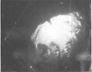
Hurricane Flora is among the deadliest Atlantic hurricanes in recorded history, with a death total of at least 7,193. The seventh tropical storm and sixth hurricane of the 1963 Atlantic hurricane season, Flora developed from a disturbance in the Intertropical Convergence Zone on September 26 while located 755 miles (1,215 km) southwest of the Cape Verde islands. After remaining a weak depression for several days, it rapidly organized on September 29 to attain tropical storm status. Flora continued to strengthen, reaching Category 3 hurricane status after moving through the Windward Islands and passing over Tobago, and it reached maximum sustained winds of 145 miles per hour (233 km/h) in the Caribbean.

The 1953 Atlantic hurricane season was an active season, with fourteen tropical storms, six of which developed into hurricanes; four of the hurricanes attained major hurricane status. This was the first season in which an official list of female names was used to name storms in the basin. The season officially began on June 15, and lasted until November 15, although activity occurred both before and after the season's limits.

The 1899 Atlantic hurricane season featured the longest-lasting tropical cyclone in the Atlantic basin on record. There were nine tropical storms, of which five became hurricanes. Two of those strengthened into major hurricanes, which are Category 3 or higher on the modern day Saffir–Simpson scale. The first system was initially observed in the northeastern Gulf of Mexico on June 26. The tenth and final system dissipated near Bermuda on November 10. These dates fall within the period with the most tropical cyclone activity in the Atlantic. In post-season analysis, two tropical cyclones that existed in October were added to HURDAT – the official Atlantic hurricane database. At one point during the season, September 3 through the following day, a set of three tropical cyclones existed simultaneously.

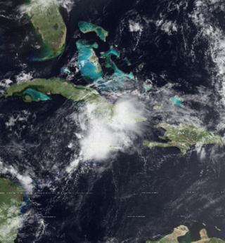
Hurricane Debby caused minor damage in the Greater and Lesser Antilles in August 2000. The seventh tropical cyclone, fourth named storm, and second hurricane of the annual season, Debby developed from a tropical wave east of the Lesser Antilles on August 19. Favorable conditions allowed the depression to become Tropical Storm Debby early on August 20, and further strengthening into a hurricane occurred 24 hours later. Sustained winds peaked at 85 mph (137 km/h) on August 21. Debby made three landfalls on August 22, in Barbuda, Saint Barthélemy, and Virgin Gorda, before re-entering the Atlantic north of Puerto Rico. As Debby moved parallel to the north coast of Hispaniola late on August 23, it weakened back to a tropical storm. The storm tracked westward and weakened further, instead of approaching Florida and strengthening into a major hurricane. While south of eastern Cuba on August 24, Debby was downgraded to a tropical depression, six hours before completely dissipating.

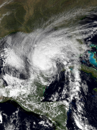
Hurricane Ernesto was the costliest tropical cyclone of the 2006 Atlantic hurricane season. The sixth tropical storm and first hurricane of the season, Ernesto developed from a tropical wave on August 24 in the eastern Caribbean Sea. Ernesto first affected the northern Caribbean, reaching minimal hurricane status near Haiti before weakening and moving across eastern Cuba as a tropical storm. Despite initial predictions for it to track through the eastern Gulf of Mexico as a major hurricane, Ernesto moved across eastern Florida as a weak tropical storm. After turning to the northeast, it re-intensified and made landfall on August 31 on the North Carolina coast just below hurricane status. Late the next day, Ernesto became extratropical after entering southern Virginia. The remnants spread moisture across the northeastern United States before dissipating over eastern Canada on September 4.

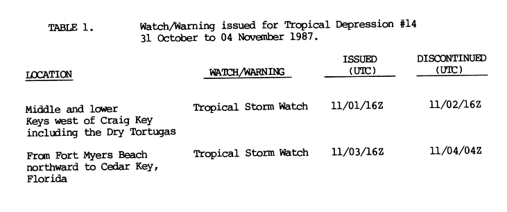
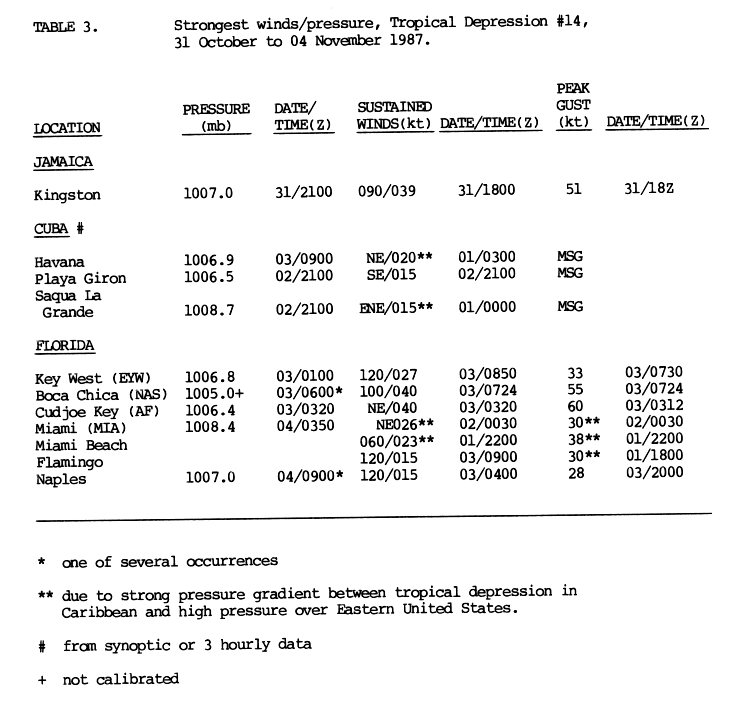
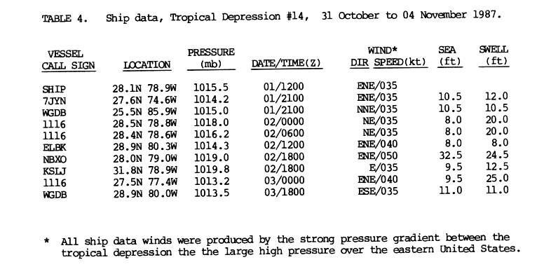
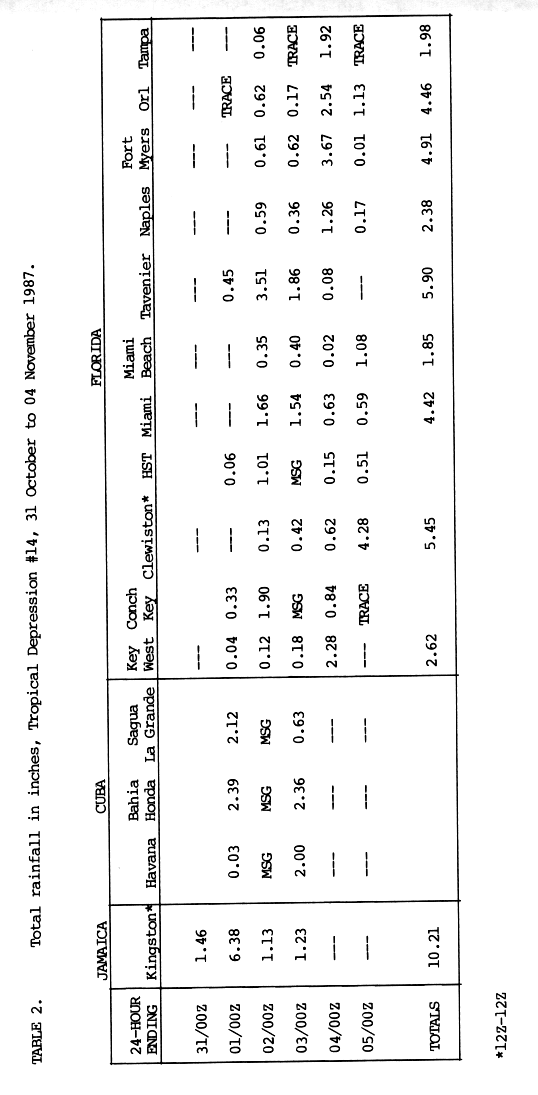
The 1987 Atlantic hurricane season was a below-average hurricane season that was limited by an ongoing El Niño. The season officially began on June 1, 1987, and lasted until November 30, 1987, although activity began on May 24 when a tropical depression developed 400 mi (640 km) east of the central Bahamas. The June through November dates conventionally delimit the period of each year when most tropical cyclones form in the Atlantic basin. The first cyclone to attain tropical storm status was an unnamed tropical storm which formed on August 9, nearly a month later than usual. The final storm of the year, Tropical Depression Fourteen, merged with a weak extratropical low on November 4. The season marked the first year tropical storm watches and warnings were issued; previously, gale watches and warnings were used for tropical storms, and this season was one of only a few seasons with no deaths in the United States; the last time this happened was in the 1981 season.

Hurricane Alberto was a Category 1 hurricane that caused the worst flooding in western Cuba in 32 years. The first tropical storm and hurricane of the 1982 Atlantic hurricane season, Alberto developed from a tropical disturbance on June 2 in the southern Gulf of Mexico. It rapidly organized and attained hurricane status the following day, the earliest date for a hurricane in the Atlantic Ocean since Hurricane Alma in May 1970. Shortly after reaching peak winds off 85 mph (137 km/h), Alberto rapidly weakened due to approaching upper-level winds. Initial forecasts predicted the hurricane would continue northeastward into Florida; it turned sharply westward and drifted erratically for several days across the eastern Gulf of Mexico, before dissipating on June 6.
Tropical Storm Keith struck the Continental United States later in the calendar year than any tropical cyclone since the 1925 Atlantic hurricane season. The nineteenth tropical depression and eleventh named storm of the 1988 Atlantic hurricane season, Keith developed out of a tropical wave in the Caribbean Sea on November 17. It tracked northwestward, and under generally favorable conditions, Keith reached a peak intensity of 70 mph (110 km/h) shortly before striking the northeastern tip of the Yucatán Peninsula. It turned northeastward in the Gulf of Mexico, and made landfall near Sarasota, Florida, on November 23. Keith accelerated its forward motion under the influence of a cold front, and became extratropical near Bermuda on November 24. The extratropical remnant persisted for two more days.
Hurricane Alma was one of only four Atlantic tropical cyclones to reach hurricane status in the month of May. It developed on May 18, 1970 north of Panama, and rapidly intensified on May 20 to peak winds of 75 mph (120 km/h), near Jamaica and the Cayman Islands. It stalled south of Cuba and deteriorated due to wind shear, and by May 22 it weakened to tropical depression status. After progressing northwestward and crossing western Cuba, Alma reorganized in the Gulf of Mexico, although continued shear prevented strengthening. It moved across Florida on May 25, and on May 27 it dissipated off the coast of Virginia.
Tropical Depression One brought severe flooding to Jamaica in June 1979. The second tropical cyclone of the Atlantic hurricane season, the depression developed from a tropical wave to the south of Grand Cayman on June 11. Tracking generally northward, the depression passed west of Jamaica. On June 12, the depression peaked with maximum sustained winds of 35 mph (55 km/h), never having reached tropical storm status. The following day, it made landfall in Cuba, where minimal impact was recorded. Early on June 14, the depression emerged into the western Atlantic Ocean and then moved parallel to the east coast of Florida for a few days. The depression made another landfall in South Carolina on June 16 and dissipated shortly thereafter.


