Cudjoe Key, Florida

Last updated

Cudjoe Key, Florida
"Venture Out" Resort- Cudjoe Key, Florida (8032608676).jpg
An aerial view of the Venture Out resort, on the southeast side of Cudjoe Key, in 1983
Monroe County Florida Incorporated and Unincorporated areas Cudjoe Key Highlighted.svg
Location in Monroe County and the state of Florida
Cudjoe Key.png
U.S. Census Bureau map showing CDP boundaries
Coordinates: 24°39′51″N81°28′56″W / 24.66417°N 81.48222°W / 24.66417; -81.48222
Country Flag of the United States.svg  United States
State Flag of Florida.svg  Florida
County   Monroe
Area
[1]
  Total10.45 sq mi (27.07 km2)
  Land5.17 sq mi (13.40 km2)
  Water5.28 sq mi (13.67 km2)
Elevation
5 ft (2 m)
Population
 (2020) [2]
  Total2,019
  Density390.22/sq mi (150.66/km2)
Time zone UTC-5 (Eastern (EST))
  Summer (DST) UTC-4 (EDT)
ZIP code
33042
Area code 305
FIPS code 12-15862 [3]
GNIS feature ID1867131 [4]

Cudjoe Key is a census-designated place and unincorporated community in Monroe County, Florida, United States, on an island of the same name in the lower Florida Keys. As of the 2020 census, the CDP had a population of 2,019, [2] up from 1,763 in 2010. [5]

Contents

History

Toponymy

The island was called "Littleton Island" in 1772. The name changed to Cudjoe's by 1849, later shortened to Cudjoe. It may have been named for the Joewood or Cudjoe wood tree ( Jacquinia keyensis ) which grows on the island. John Viele notes that "Cudjoe" is an Akan name, and may have been the name of an escaped slave who lived on the island early in the 19th century. [6] [7]

20th century

The United States Army activated Cudjoe Key Air Force Station in 1959 to track missiles traveling through the Eglin Gulf Test Range. The Air Force took over operations the following year, [8] and it subsequently became a detached installation of Homestead Joint Air Reserve Base. [9]

21st century

The air force station flies a white radar aerostat, known locally as "Fat Albert", which is used for drug interdiction missions by the Drug Enforcement Administration. On April 20, 2007, a Cessna 182 crashed after its left wing struck the tether anchoring "Fat Albert". [10] [11] The aerostat is marked on air navigation charts inside a restricted area that contains the warning, "Caution: Unmarked balloon on cable to 14,000 [feet]."

On September 10, 2017, Cudjoe Key suffered a direct hit from Hurricane Irma which made landfall as a Category 4 hurricane. [12]
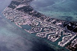
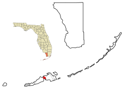
Geography

Cudjoe Key is located in the Florida Keys at 24°39′51″N81°28′56″W / 24.66417°N 81.48222°W / 24.66417; -81.48222 (24.664298, -81.482339). [13] U.S. 1 (or the Overseas Highway) crosses the key at about mile markers 20.5  23, between Summerland and Sugarloaf Keys. The highway leads west-southwest 20 miles (32 km) to Key West, east 30 miles (48 km) to Marathon, and a total of 136 miles (219 km) northeast to Miami.

According to the United States Census Bureau, the CDP has a total area of 10.5 square miles (27 km2), of which 5.2 square miles (13 km2) are land and 5.3 square miles (14 km2), or 50.5%, are water. [1] The water area includes Cudjoe Bay to the south of the island, a portion of Kemp Channel to the east, and tidal water to the northwest between Cudjoe Key and small islands known as the Rattlesnake Lumps. [14]

Demographics

Historical population
CensusPop.Note
1990 1,714
2000 1,695−1.1%
2010 1,7634.0%
2020 2,01914.5%
U.S. Decennial Census [15]

As of the census [3] of 2000, there were 1,695 people, 799 households, and 541 families residing in the CDP. The population density was 124.9/km2 (323.6/mi2). There were 1,482 housing units at an average density of 109.2/km2 (282.9/mi2). The racial makeup of the CDP was 96.22% White, 0.88% African American, 0.47% Native American, 0.88% Asian, 0.12% Pacific Islander, 0.71% from other races, and 0.71% from two or more races. Hispanic or Latino of any race were 5.66% of the population.

There were 799 households, out of which 15.6% had children under the age of 18 living with them, 62.0% were married couples living together, 3.4% had a female householder with no husband present, and 32.2% were non-families. 21.7% of all households were made up of individuals, and 7.8% had someone living alone who was 65 years of age or older. The average household size was 2.12 and the average family size was 2.43.

In the CDP, the population was spread out, with 12.2% under the age of 18, 3.7% from 18 to 24, 27.1% from 25 to 44, 38.8% from 45 to 64, and 18.2% who were 65 years of age or older. The median age was 48 years. For every 100 females, there were 108.2 males. For every 100 females age 18 and over, there were 109.4 males.

The median income for a household in the CDP was $57,500, and the median income for a family was $59,883. Males had a median income of $36,094 versus $31,250 for females. The per capita income for the CDP was $27,085. About 4.4% of families and 5.8% of the population were below the poverty line, including 5.7% of those under age 18 and 5.4% of those age 65 or over.

Related Research Articles

<span class="mw-page-title-main">Washington Park, Florida</span> CDP in Florida, United States

Washington Park is a census-designated place (CDP) in Broward County, Florida, United States. Its population was 1,948 at the 2020 census.

<span class="mw-page-title-main">Sylvan Shores, Florida</span> Unincorporated community in Florida, United States

Sylvan Shores is an unincorporated community and former census-designated place (CDP) in Highlands County, Florida, United States, located immediately northeast of the town of Lake Placid. As of the 2000 census, the CDP population was 2,424.

<span class="mw-page-title-main">Pineland, Florida</span> Census-designated place in Florida, United States

Pineland is an unincorporated community and census-designated place (CDP) on Pine Island in Lee County, Florida, United States. The population was 466 at the 2020 census. It is part of the Cape Coral-Fort Myers, Florida Metropolitan Statistical Area.

<span class="mw-page-title-main">Duck Key, Florida</span> Census-designated place in Florida, United States

Duck Key is a census-designated place and unincorporated community in Monroe County, Florida, United States, on an island of the same name in the middle Florida Keys. The CDP also includes the neighboring island of Conch Key. As of the 2020 census, the CDP had a population of 727, up from 621 in 2010.

<span class="mw-page-title-main">Key Largo, Florida</span> Census-designated place in Florida, United States

Key Largo is an unincorporated area and census-designated place in Monroe County, Florida, United States, located on the island of Key Largo in the upper Florida Keys. The population was 12,447 at the 2020 census, up from 10,433 in 2010. The name comes from the Spanish Cayo Largo, or "long key". It is both the first island and town of the Florida Keys to be reached from the Overseas Highway to Key West. It was also the location of one of the stations of the Overseas Railroad.

<span class="mw-page-title-main">North Key Largo, Florida</span> Census-designated place in Florida, United States

North Key Largo is an unincorporated area and census-designated place (CDP) in Monroe County, Florida, United States. The population was 1,431 at the 2020 census, up from 1,244 in 2010. It includes two private clubs, the Ocean Reef Club and the Key Largo Anglers Club, and is reached from the mainland via the Card Sound Bridge.

<span class="mw-page-title-main">Stock Island, Florida</span> Census-designated place in Florida, United States

Stock Island is a census-designated place (CDP) and unincorporated community on an island of the same name in Monroe County, Florida, United States. The population of the CDP was 4,722 at the 2020 census, up from 3,919 in 2010. It is located on the portion of the island south of US 1. It is supposedly named for the herds of livestock formerly kept there. Alternatively, some local historians suggest that it may be named for an early settler.

<span class="mw-page-title-main">Tavernier, Florida</span> Census-designated place in Florida, United States

Tavernier is a census-designated place (CDP) and unincorporated community in Monroe County, Florida, United States on Key Largo, the largest island in the upper Florida Keys. Tavernier's population was 2,530 at the 2020 census, up from 2,136 in 2010.

<span class="mw-page-title-main">Zellwood, Florida</span> Census-designated place in Florida, United States

Zellwood is a census-designated place and an unincorporated area in Orange County, Florida, United States. The population was 2,817 at the 2010 census. It is part of the Orlando–Kissimmee Metropolitan Statistical Area.

<span class="mw-page-title-main">Cypress Lakes, Florida</span> Unincorporated place in Florida, United States

Cypress Lakes was a former census-designated place (CDP) and current unincorporated place in Palm Beach County, Florida, United States. The population was 1,468 at the 2000 census.

Plantation Mobile Home Park is a census-designated place (CDP) in Palm Beach County, Florida, United States. It is part of the Miami metropolitan area of South Florida. The population was 1,462 at the 2020 US census.

<span class="mw-page-title-main">Feather Sound, Florida</span> Census-designated place in Florida, United States

Feather Sound is a census-designated place (CDP) in Pinellas County, Florida, United States. The population was 3,420 at the 2010 census. It includes the St. Petersburg-Clearwater International Airport.

<span class="mw-page-title-main">Wekiwa Springs, Florida</span> CDP in Florida, United States

Wekiwa Springs is a census-designated place and an unincorporated area in Seminole County, Florida, United States. The population was 23,169 at the 2000 census. It is part of the Orlando–Kissimmee–Sanford, Florida Metropolitan Statistical Area.

<span class="mw-page-title-main">Vineyard Haven, Massachusetts</span> Census-designated place in Massachusetts, United States

Vineyard Haven is a community within the town of Tisbury, Massachusetts on the island of Martha's Vineyard. It is listed as a census-designated place (CDP) by the U.S. Census Bureau with a population of 2,114 as of the 2010 census.

<span class="mw-page-title-main">Westgate, Florida</span> CDP in Florida, United States

Westgate is an unincorporated census-designated place (CDP) in Palm Beach County, Florida, United States. Prior to the 2010 US census, the CDP was listed as Westgate-Belvedere Homes. It is part of the Miami metropolitan area of South Florida. The population was 8,435 at the 2020 census.

<span class="mw-page-title-main">Crystal Lake, Polk County, Florida</span> Census-designated place in Florida, United States

Crystal Lake is a census-designated place (CDP) in Polk County, Florida, United States. The population was 5,341 at the 2000 census, an increase from 5,300 in 1990. The 2010 Census reported a population of 5,514. It is part of the Lakeland–Winter Haven Metropolitan Statistical Area.

<span class="mw-page-title-main">Ashaway, Rhode Island</span> Village and CDP in Hopkinton, Rhode Island, US

Ashaway is an unincorporated village and census-designated place (CDP) in the town of Hopkinton, Rhode Island, USA. It is a principal village of Hopkinton, along with Hope Valley, although it is the smaller of the two. The population was 1,485 at the 2010 census. The name Ashaway is derived from the American Indian name for the river that runs through the village, the Ashawague or Ashawaug, which means "land in the middle" or "land between" in the Niantic and Mohegan languages. The name "Ashawague River" appears as late as 1832 on the Findley map of Rhode Island published in Philadelphia.

<span class="mw-page-title-main">Hope Valley, Rhode Island</span> Census-designated place in Rhode Island, United States

Hope Valley is a village and census-designated place (CDP) in the town of Hopkinton, Rhode Island, United States. The population of the CDP was 1,612 at the 2010 census. Hope Valley is the largest village in Hopkinton, and the town's principal commercial center. While the village of Hope Valley is located in Hopkinton, its zip code, 02832, extends into the neighboring town of Richmond.

<span class="mw-page-title-main">Loch Lomond, Virginia</span> Census-designated place in Virginia, United States

Loch Lomond is a census-designated place (CDP) in Prince William County, Virginia, United States. The population was 3,701 at the 2010 census. It is named after a loch in northern Scotland, Loch Lomond.

<span class="mw-page-title-main">Big Coppitt Key</span> Census-designated place in Florida, United States

Big Coppitt Key is an island in Monroe County, Florida, United States, in the lower Florida Keys. The name is said to be a derivation of the old English word "coppice", meaning thicket. According to A.D. Bache, in the notes for his coast survey conducted in 1861, this key was the location of Happy Jack's plantation in 1855.

References

  1. 1 2 "2022 U.S. Gazetteer Files: Florida". United States Census Bureau. Retrieved January 18, 2023.
  2. 1 2 "P1. Race – Cudjoe Key CDP, Florida: 2020 DEC Redistricting Data (PL 94-171)". U.S. Census Bureau. Retrieved January 18, 2023.
  3. 1 2 "U.S. Census website". United States Census Bureau . Retrieved January 31, 2008.
  4. "US Board on Geographic Names". United States Geological Survey. October 25, 2007. Retrieved January 31, 2008.
  5. "P1. Race – Cudjoe Key CDP, Florida: 2010 DEC Redistricting Data (PL 94-171)". U.S. Census Bureau. Retrieved January 18, 2023.
  6. "A small tree for tough landscapes: joewood". Fairchild Tropical Botanic Garden. August 25, 2013. Retrieved May 19, 2019.
  7. Culper, Jim. "Cudjoe Key". Archived from the original on July 20, 2008. Retrieved May 19, 2019.
  8. "History of Cudjoe Key AFS, FL". Online Air Defense Radar Museum. Radomes, Inc. Retrieved December 12, 2009.
  9. Mueller, Roger (1989). Air Force Bases. Diane Publishing. pp. 253–255. ISBN   978-1-4289-9316-7.
  10. Dellert, Christine (May 17, 2007). "NTSB: Pilot was warned before crash". Orlando Sentinel. Retrieved September 10, 2017.
  11. "NTSB Identification: MIA07FA083". NTSB . Archived from the original on September 29, 2007.
  12. Padró Ocasio, Bianca (September 10, 2017). "Hurricane Irma makes landfall in Cudjoe Key". Orlando Sentinel. Retrieved September 10, 2017.
  13. "US Gazetteer files: 2010, 2000, and 1990". United States Census Bureau. February 12, 2011. Retrieved April 23, 2011.
  14. "TIGERweb Decennial: Cudjoe Key CDP, Florida". Geography Division: U.S. Census Bureau. Retrieved January 18, 2023.
  15. "Census of Population and Housing". Census.gov. Retrieved June 4, 2016.