Monroe County is a county in the state of Florida. As of the 2020 census, the population was 82,874. Its county seat is Key West. Monroe County includes the islands of the Florida Keys and comprises the Key West Micropolitan Statistical Area. Over 99.9% of the county's population lives on the Florida Keys. The mainland, which is part of the Everglades, comprises 87% of the county's land area and is virtually uninhabited with only 17 people in total.

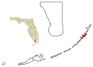
Islamorada is an incorporated village in Monroe County, Florida. It is located directly between Miami and Key West on five islands—Tea Table Key, Lower Matecumbe Key, Upper Matecumbe Key, Windley Key and Plantation Key—in the Florida Keys.
Key Largo is a census-designated place in Monroe County, Florida, United States, located on the island of Key Largo in the upper Florida Keys. The population was 12,447 at the 2020 census. The name comes from the Spanish Cayo Largo, or "long key". It is both the first island and town of the Florida Keys to be reached from the Overseas Highway to Key West. It was also the location of one of the stations of the Overseas Railroad.

Tavernier is a census-designated place (CDP) and unincorporated community in Monroe County, Florida, United States on Key Largo, the largest island in the upper Florida Keys. Tavernier's population was 2,530 at the 2020 census.
The Florida Keys are a coral cay archipelago located off the southern coast of Florida, forming the southernmost part of the continental United States. They begin at the southeastern coast of the Florida peninsula, about 15 miles (24 km) south of Miami, and extend in a gentle arc south-southwest and then westward to Key West, the westernmost of the inhabited islands, and on to the uninhabited Dry Tortugas. The islands lie along the Florida Straits, dividing the Atlantic Ocean to the east from the Gulf of Mexico to the northwest, and defining one edge of Florida Bay. At the nearest point, the southern part of Key West is just 93 miles (150 km) from Cuba. The Florida Keys are between about 24.3 and 25.5 degrees North latitude.

Key Largo is an island in the upper Florida Keys archipelago and is the largest section of the Keys, at 33 miles (53 km) long. It is one of the northernmost of the Florida Keys in Monroe County, and the northernmost of the Keys connected by U.S. Highway 1. Three census-designated places are on the island of Key Largo: North Key Largo, near the Card Sound Bridge, Key Largo, eight or nine miles from the southern end of the island, and Tavernier, at the southern end of the island. As of 2010, the three places have a combined population of 13,850. None of Key Largo is an incorporated municipality, so it is governed at the local level by Monroe County.

Key Biscayne is an island located in Miami-Dade County, Florida, located between the Atlantic Ocean and Biscayne Bay. It is the southernmost of the barrier islands along the Atlantic coast of Florida, and lies south of Miami Beach and southeast of Miami. The key is connected to Miami via the Rickenbacker Causeway, originally built in 1947.

Long Key is an island in the middle Florida Keys. Long Key was called Cayo Víbora by early Spanish explorers, a reference to the shape of the island, which resembles a snake with its jaws open, rather than to its denizens. The city of Layton is located on Long Key. The 965-acre (3.9 km2) state park (3.9 km²) was dedicated October 1, 1969.

The Overseas Highway is a 113-mile (181.9 km) highway carrying U.S. Route 1 (US 1) through the Florida Keys to Key West. Large parts of it were built on the former right-of-way of the Overseas Railroad, the Key West Extension of the Florida East Coast Railway. Completed in 1912, the Overseas Railroad was heavily damaged and partially destroyed in the 1935 Labor Day hurricane. The Florida East Coast Railway was financially unable to rebuild the destroyed sections, so the roadbed and remaining bridges were sold to the state of Florida for $640,000.

Elliott Key is the northernmost of the true Florida Keys, and the largest key north of Key Largo. It is located entirely within Biscayne National Park, in Miami-Dade County, Florida, east of Homestead, Florida. It is bordered by the Atlantic Ocean to the east, Biscayne Bay to the west, Sands Key to the north and Old Rhodes Key to the south. Adams Key is just west of the southern end of Elliott Key. Elliott Key is about seven miles (11 km) long. Its maximum width is about 2,500 feet (760 m) near the north end and its average width is less than 2,000 feet (610 m). The higher elevations on the island range from 6 to 8 feet above sea level and occur generally along an unimproved road that runs longitudinally through the center of the island. The average elevation is about 3 feet (0.91 m) above sea level. The key is accessible only by boat. Elliott Key has a National Park Service campground, but is otherwise uninhabited.

Lower Matecumbe Key is an island in the upper Florida Keys, United States, located on U.S. 1 between mile markers 75–78.

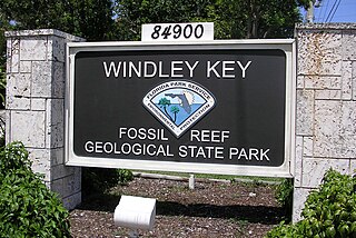
Windley Key Fossil Reef Geological State Park is a Florida State Park located at mile marker 85.5 near Islamorada. It was a former quarry used by Henry Flagler in the early 1900s to help his building of the Overseas Railroad. Following the railroad's completion, it was a source for decorative stone pieces called Keystone. Now on display are exposed sections of fossilized coral, as well as some of the original quarry machinery. The Hurricane Monument at Mile Marker 82 in Islamorada is constructed of keystone from the quarry.
Plantation Key, Florida is a former census-designated place on Plantation Key in the Florida Keys, in Monroe County, Florida, United States. It is located just South of the Tavernier bridge and North of the Snake Creek bridge and was reported to have a population of 4,405 in 1990. It became part of the Village of Islamorada when the latter incorporated in 1997.
U.S. Highway 1 (US 1) in Florida runs 545 miles (877 km) along the state's east coast from Key West to its crossing of the St. Marys River into Georgia north of Boulogne and south of Folkston. US 1 was designated through Florida when the U.S. Numbered Highway System was established in 1926. The road is maintained by the Florida Department of Transportation (FDOT).
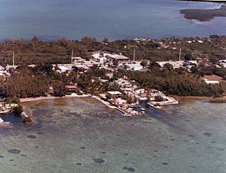
Windley Key is an island in the upper Florida Keys in Monroe County, Florida, United States. U.S. 1 crosses it at approximately mile markers 84–85.5, between Plantation Key and Upper Matecumbe Key. All of the key is within the Village of Islamorada as of November 4, 1997, when it was incorporated.
Upper Matecumbe Key is an island in the upper Florida Keys.

Monroe County School District is a public school district serving the residents of Monroe County, Florida. The district's administrative offices are headquartered in Key West, Florida, United States, with school sites located throughout the Florida Keys from Key West to Key Largo. The district provides educational services for students enrolled in Pre-Kindergarten through 12th grade and educational opportunities for adult learners enrolled through adult education programs.
Plantation Key Colony is a neighborhood located in the upper Florida Keys on the island of Plantation Key. Its name is in reference to the pineapple plantation originally in the area. All homes and real estate located on Plantation Key, just South of the Tavernier bridge and North of the Snake Creek bridge, are officially part of the Village of Islamorada, pay Village taxes and are provided services from the Village of Islamorada even through some homes on the Northern edge of the Key still maintain Tavernier zip codes.
A hurricane local statement (HLS) is a weather statement produced for the public by the local Weather Forecast Offices of the National Weather Service in the U.S. for areas affected or forecast to be affected by a tropical storm or hurricane that provides an overview of the storm's local effects, including expected weather conditions, evacuation decisions made by local officials, and precautions necessary to protect life and property. The National Weather Services considers the HLS to be the "flagship product" available to Weather Forecast Offices for outlining tropical cyclone watches and warnings and impacts, and is their most visible product during such events. Descriptions of the affected areas, relevant tropical cyclone watches and warnings, recommendations for precautionary measures, and expected timing and severity of possible threats are typically included in an HLS. The HLS can incorporate projected impacts from pre-written descriptions tailored for different storm intensities; these template descriptions were developed in the 1990s and became widely available to forecasters for use in the HLS by 2001. The bulletin issued by the Weather Forecast Office in Slidell, Louisiana, as Hurricane Katrina approached on August 28, 2005, known as "The Bulletin", was lauded by the National Weather Service as having further encouraged vulnerable individuals to evacuate. Not all forecast offices can issue an HLS.

Snake Creek Bridge is a bascule bridge in the village of Islamorada in the Florida Keys. The single-leaf steel bascule bridge carries the Overseas Highway over Snake Creek, connecting Plantation Key and Windley Key. It is located near mile marker 86.