Big Pine Key is a census-designated place and unincorporated community in Monroe County, Florida, United States, on an island of the same name in the Florida Keys. As of the 2020 census, the town had a total population of 4,521.

Key West is an island in the Straits of Florida, within the U.S. state of Florida. Together with all or parts of the separate islands of Dredgers Key, Fleming Key, Sunset Key, and the northern part of Stock Island, it constitutes the City of Key West.

Marathon is a city in the middle of the Florida Keys, in Monroe County, Florida, United States. As of the 2020 census, the city had a population of 9,689, up from 8,297 in 2010.

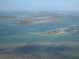
The Florida Keys are a coral cay archipelago off the southern coast of Florida, forming the southernmost part of the continental United States. They begin at the southeastern coast of the Florida peninsula, about 15 miles (24 km) south of Miami and extend in a gentle arc south-southwest and then westward to Key West, the westernmost of the inhabited islands, and on to the uninhabited Dry Tortugas. The islands lie along the Florida Straits, dividing the Atlantic Ocean to the east from the Gulf of Mexico to the northwest, and defining one edge of Florida Bay. The southern part of Key West is 93 miles (150 km) from Cuba. The Keys are located between about 24.3 and 25.5 degrees North latitude.

The Overseas Highway is a 113-mile (181.9 km) highway carrying U.S. Route 1 (US 1) through the Florida Keys to Key West. Large parts of it were built on the former right-of-way of the Overseas Railroad, the Key West Extension of the Florida East Coast Railway. Completed in 1912, the Overseas Railroad was heavily damaged and partially destroyed in the 1935 Labor Day hurricane. The Florida East Coast Railway was financially unable to rebuild the destroyed sections, so the roadbed and remaining bridges were sold to the state of Florida for $640,000.

Sea Base, formerly known as Florida National High Adventure Sea Base, is a high adventure program base run by the Boy Scouts of America (BSA) in the Florida Keys. Its counterparts are the Philmont Scout Ranch in northern New Mexico, the Northern Tier National High Adventure Bases in Ely, Minnesota as well as Manitoba and Ontario in Canada, and The Summit Bechtel Family National Scout Reserve near the New River Gorge National Park in southern West Virginia.
Key Vaca is an island in the middle Florida Keys, located entirely within the borders of the city of Marathon, Florida.

No Name Key is an island in the lower Florida Keys in the United States. It is 3 miles (4.8 km) from US 1 and sparsely populated, with only 43 homes. It is only about 1,140 acres in comparison to its larger neighbor, Big Pine Key, which lies about half a mile (800 m) to its west. It is accessible by a concrete bridge from Big Pine Key and was the terminus of a car ferry that existed before the present Overseas Highway was built on the remains of Flagler's Overseas Railroad.

Big Talbot Island State Park is a state park in Florida, United States. It is located on Big Talbot Island, a coastal barrier island 20 miles east of downtown Jacksonville on A1A North and immediately north of Little Talbot Island State Park along the Atlantic coastal plain.
U.S. Highway 1 (US 1) in Florida runs 545 miles (877 km) along the state's east coast from Key West to its crossing of the St. Marys River into Georgia north of Boulogne and south of Folkston. US 1 was designated through Florida when the U.S. Numbered Highway System was established in 1926. With the exception of Monroe County, the highway runs through the easternmost tier of counties in the state, connecting numerous towns and cities along its route, including nine county seats. The road is maintained by the Florida Department of Transportation (FDOT).

Ramrod Key is an island in the lower Florida Keys. Originally named Roberts Island, Ramrod Key was renamed for a ship named Ramrod, which was wrecked on a reef south of there in the early nineteenth century.

US 1 crosses the Ohio Key at approximately mile marker 39, between Missouri Key and Bahia Honda Key. Today it is also known as Sunshine Key, after a camping resort located there. The portion of the island south of U.S. Route 1 is protected as the Ohio Key National Wildlife Refuge.
Bahia Honda is an island in the lower Florida Keys.

Little Duck Key is a small island in the lower Florida Keys.
Fat Deer Key is an island in the middle Florida Keys.

Crawl Key is an island in the middle Florida Keys.
Middle Torch Key is an island in the lower Florida Keys.

Big Torch Key is an island in the lower Florida Keys.
The Torch Keys are three islands in the lower Florida Keys, consisting of Little Torch Key, Middle Torch Key, and Big Torch Key. Little Torch Key is the most populated of the three. The islands were named for their forests of Sea Torchwood, which are effective as kindling even when green. The Torch Keys are located just west of Big Pine Key, or about 28 miles (45 km) east of Key West.

Grassy Key, Florida, is an island in the middle Florida Keys. It is located on U.S. 1, near mile markers 57—60, below the Conch Keys. It has an area of 3.65 km², with a population of 974 as of the census 2000.