
Big Pine Key is a census-designated place and unincorporated community in Monroe County, Florida, United States, on an island of the same name in the Florida Keys. As of the 2020 census, the town had a total population of 4,521.
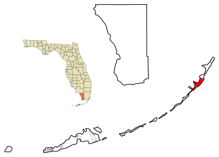
Key Largo is an unincorporated area and census-designated place in Monroe County, Florida, United States, located on the island of Key Largo in the upper Florida Keys. The population was 12,447 at the 2020 census, up from 10,433 in 2010. The name comes from the Spanish Cayo Largo, or "long key". It is both the first island and town of the Florida Keys to be reached from the Overseas Highway to Key West. It was also the location of one of the stations of the Overseas Railroad.

Key West is an island in the Straits of Florida, within the U.S. state of Florida. Together with all or parts of the separate islands of Dredgers Key, Fleming Key, Sunset Key, and the northern part of Stock Island, it constitutes the City of Key West.

Marathon is a city in the middle of the Florida Keys, in Monroe County, Florida, United States. As of the 2020 census, the city had a population of 9,689, up from 8,297 in 2010.

The Florida Keys are a coral cay archipelago off the southern coast of Florida, forming the southernmost part of the continental United States. They begin at the southeastern coast of the Florida peninsula, about 15 miles (24 km) south of Miami and extend in a gentle arc south-southwest and then westward to Key West, the westernmost of the inhabited islands, and on to the uninhabited Dry Tortugas. The islands lie along the Florida Straits, dividing the Atlantic Ocean to the east from the Gulf of Mexico to the northwest, and defining one edge of Florida Bay. The southern part of Key West is 93 miles (150 km) from Cuba. The Keys are located between about 24.3 and 25.5 degrees North latitude.

Key Largo is an island in the upper Florida Keys archipelago and is the largest section of the keys, at 33 miles (53 km) long. It is one of the northernmost of the Florida Keys in Monroe County, and the northernmost of the keys connected by U.S. Highway 1. Three census-designated places are on the island of Key Largo: North Key Largo, near the Card Sound Bridge, Key Largo, eight to nine miles from the southern end of the island, and Tavernier, at the southern end of the island. As of 2010, the three places have a combined population of 13,850. None of Key Largo is an incorporated municipality, so it is governed at the local level by Monroe County.

Long Key is an island in the middle Florida Keys. Long Key was called Cayo Víbora by early Spanish explorers, a reference to the shape of the island, which resembles a snake with its jaws open, rather than to its denizens. The city of Layton is located on Long Key. The 965-acre (3.9 km2) state park (3.9 km²) was dedicated October 1, 1969.

The Overseas Highway is a 113-mile (181.9 km) highway carrying U.S. Route 1 (US 1) through the Florida Keys to Key West. Large parts of it were built on the former right-of-way of the Overseas Railroad, the Key West Extension of the Florida East Coast Railway. Completed in 1912, the Overseas Railroad was heavily damaged and partially destroyed in the 1935 Labor Day hurricane. The Florida East Coast Railway was financially unable to rebuild the destroyed sections, so the roadbed and remaining bridges were sold to the state of Florida for $640,000.

Hānaiakamalama or Queen Emma Summer Palace, served as a retreat for Queen Emma of Hawaii from 1857 to 1885, as well as for her husband King Kamehameha IV, and their son, Prince Albert Edward. It is a now a historic landmark, museum, and tourist site located at 2913 Pali Highway, less than a ten-minute drive outside of downtown Honolulu, Hawaii. The museum is open daily from 9:00 a.m. to 4:00 p.m., and is maintained with entrance fees, revenue from the gift shop, and other funds raised by the Daughters of Hawaii.
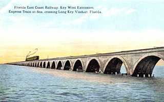
The Overseas Railroad was an extension of the Florida East Coast Railway to Key West, a city located 128 miles (206 km) beyond the end of the Florida peninsula. Work on the line started in 1905 and it operated from 1912 to 1935, when it was partially destroyed by the Labor Day Hurricane. Some of the remaining infrastructure was used for the Overseas Highway.
Key Vaca is an island in the middle Florida Keys, located entirely within the borders of the city of Marathon, Florida.
Lignumvitae Key Botanical State Park is a Florida State Park consisting of Lignumvitae Key, Shell Key, surrounding submerged lands, and a parcel at the northern end of Lower Matecumbe Key. The islands are located one mile west of U.S. 1 at mile marker 78.5, and can be reached only by private boat or tour boat.

Sugarloaf Key is a single island in the lower Florida Keys that forms a loop on the Atlantic Ocean side, giving the illusion of separate islands. Although frequently referred to simply and with technical accuracy as "Sugarloaf Key", this island contains two distinct island communities, known as Lower Sugarloaf Key and Upper Sugarloaf Key.

Knights Key is an island in the middle Florida Keys, located entirely within the borders of the city of Marathon, Florida.
Long Point Key is an island in the middle Florida Keys.

Crawl Key is an island in the middle Florida Keys.
Craig Key is an island city in the middle Florida Keys.

Upper Sugarloaf Key is located in the Florida Keys. It located between MM20.5-MM19 and bridge number 28/29 at Bow Channel/Park Key. U.S. 1 crosses the key at approximately mile markers 19–20.5. Upper Sugarloaf Key is located about 15 miles east of Key West, between Park Key and Cudjoe Key. It is the upper arm of a large island, Sugarloaf Key, that includes Lower Sugarloaf Key.

Little Conch Key is an island in Monroe County, Florida, United States. Little Conch Key is also known as Walker's Island.

Grassy Key, Florida, is an island in the middle Florida Keys. It is located on U.S. 1, near mile markers 57—60, below the Conch Keys. It has an area of 3.65 km², with a population of 974 as of the census 2000.


