A screw-pile lighthouse is a lighthouse which stands on piles that are screwed into sandy or muddy sea or river bottoms. The first screw-pile lighthouse to begin construction was built by the blind Irish engineer Alexander Mitchell. Construction began in 1838 at the mouth of the Thames and was known as the Maplin Sands lighthouse, and first lit in 1841. However, though its construction began later, the Wyre Light in Fleetwood, Lancashire, was the first to be lit.

Biscayne National Park is an American national park located south of Miami, Florida in Miami-Dade County. The park preserves Biscayne Bay and its offshore barrier reefs. Ninety-five percent of the park is water, and the shore of the bay is the location of an extensive mangrove forest. The park covers 172,971 acres and includes Elliott Key, the park's largest island and northernmost of the true Florida Keys, formed from fossilized coral reef. The islands farther north in the park are transitional islands of coral and sand. The offshore portion of the park includes the northernmost region of the Florida Reef, one of the largest coral reefs in the world.

The Florida Keys are a coral cay archipelago off the southern coast of Florida, forming the southernmost part of the continental United States. They begin at the southeastern coast of the Florida peninsula, about 15 miles (24 km) south of Miami, and extend in a gentle arc south-southwest and then westward to Key West, the westernmost of the inhabited islands, and on to the uninhabited Dry Tortugas. The islands lie along the Florida Straits, dividing the Atlantic Ocean to the east from the Gulf of Mexico to the northwest, and defining one edge of Florida Bay. At the nearest point, the southern part of Key West is just 93 miles (150 km) from Cuba. The Keys are between about 24.3 and 25.5 degrees North latitude.

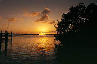
Biscayne Bay is a lagoon with characteristics of an estuary located on the Atlantic coast of South Florida. The northern end of the lagoon is surrounded by the densely developed heart of the Miami metropolitan area while the southern end is largely undeveloped with a large portion of the lagoon included in Biscayne National Park.
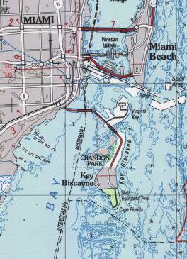
Key Biscayne is an island located in Miami-Dade County, Florida, located between the Atlantic Ocean and Biscayne Bay. It is the southernmost of the barrier islands along the Atlantic coast of Florida, and lies south of Miami Beach and southeast of Miami. The key is connected to Miami via the Rickenbacker Causeway, originally built in 1947.

Virginia Key is an 863-acre (3.49 km2) barrier island in Miami, Florida. It is located in Biscayne Bay south of Brickell and north of Key Biscayne and is accessible from the mainland via the Rickenbacker Causeway.

The Cape Florida Light is a lighthouse on Cape Florida at the south end of Key Biscayne in Miami-Dade County, Florida. Constructed in 1825, it guided mariners off the Florida Reef, which starts near Key Biscayne and extends southward a few miles offshore of the Florida Keys. It was operated by staff, with interruptions, until 1878, when it was replaced by the Fowey Rocks lighthouse. The lighthouse was put back into use in 1978 by the U.S. Coast Guard to mark the Florida Channel, the deepest natural channel into Biscayne Bay. They decommissioned it in 1990.

Bill Baggs Cape Florida State Recreation Area occupies approximately the southern third of the island of Key Biscayne, at coordinates 25°40′25″N80°09′34″W. This park includes the Cape Florida Light, the oldest standing structure in Greater Miami. In 2005, it was ranked as having the 8th best beach in the country, and in 2013 Forbes ranked it at 7th.

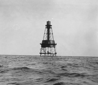
Fowey Rocks Light is located seven miles southeast of Cape Florida on Key Biscayne. The lighthouse was completed in 1878, replacing the Cape Florida Light. It was automated on May 7, 1975, and as of 2021 is still in operation. The structure is cast iron, with a screw-pile foundation, a platform and a skeletal tower. The light is 110 feet above the water. The tower framework is painted brown, while the dwelling and enclosed circular stair to the lantern is painted white. The original lens was a first-order drum Fresnel lens which stood about 12 feet (4 m) high and weighed about a ton (tonne). The light has a nominal range of 15 miles in the white sectors, and 10 miles in the red sectors.
Carysfort Reef Light is located approximately six nautical miles east of Key Largo, Florida. The lighthouse has an iron screw-pile foundation with a platform, and a skeletal, octagonal, pyramidal tower, which is painted red. The light is 100 feet (30 m) above the water. It was the oldest functioning lighthouse of its type in the United States until it was decommissioned in 2015, having been completed in 1852. Carysfort Reef is named for HMS Carysfort (1766), a 20-gun Royal Navy post ship that ran aground on the reef in 1770. The light currently installed is a xenon flashtube beacon. It was added to the National Register of Historic Places in 1984.

Egmont Key National Wildlife Refuge and State Park is a National Wildlife Refuge and State Park located on the island of Egmont Key, at the mouth of Tampa Bay. Egmont Key lies southwest of Fort De Soto Park and can only be reached by boat or ferry. Located within Egmont Key National Wildlife Refuge and State Park are the 1858 Egmont Key Lighthouse, maintained by the U.S. Coast Guard, and the ruins of Fort Dade, a Spanish–American War era fort that housed 300 residents. Egmont Key is located in Hillsborough County Florida on a narrow strip of the county that extends along the Tampa Port Shipping Channel.
Gasparilla Island State Park is a Florida State Park located south of Boca Grande on Gasparilla Island off Charlotte Harbor and Pine Island Sound. Activities include swimming and fishing along with shelling, picnicking, and viewing the Historic Port Boca Grande Lighthouse.

The Gasparilla Island Lights are on Gasparilla Island in Boca Grande, Florida. The Port Boca Grande Lighthouse is on the southern tip of Gasparilla Island, and marked the Boca Grande Pass entrance to Charlotte Harbor.

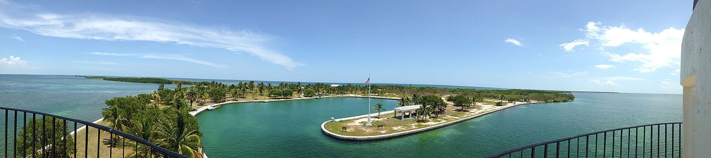
The Boca Chita Key Historic District is a U.S. historic district within the Biscayne National Park in Miami-Dade County, Homestead, Florida. Located on the northwest section of Boca Chita Key, delimited by Biscayne Bay in the north and west and a half ruined stone wall on its southern side, it contains three historic buildings and the Boca Chita Lighthouse. On 1 August 1997, it was listed in the National Register of Historic Places for its architectural, historical and recreational values.
Adams Key is an island north of the upper Florida Keys in Biscayne National Park. It is in Miami-Dade County, Florida. It is located west of the southern tip of Elliott Key, on the north side of Caesar Creek in the lower part of Biscayne Bay. The key is only accessible by boat, and overnight docking is prohibited.
Sands Key is an island north of the upper Florida Keys in Biscayne National Park. It is in Miami-Dade County, Florida.

August Geiger was one of the most prominent American architects in South Florida from 1905 to the late 1940s. He experimented in Mission, Neo-Renaissance and Art Deco architecture, but is most noted for his works in the Mediterranean Revival style. A number of his works are listed on the U.S. National Register of Historic Places.

The Florida Reef is the only living coral barrier reef in the continental United States. It is the third largest coral barrier reef system in the world. It lies a few miles seaward of the Florida Keys, is about 4 miles wide and extends 270 km (170 mi) from Fowey Rocks just east of Soldier Key to just south of the Marquesas Keys. The barrier reef tract forms a great arc, concentric with the Florida Keys, with the northern end, in Biscayne National Park, oriented north-south and the western end, south of the Marquesas Keys, oriented east-west. The rest of the reef outside Biscayne National Park lies within John Pennekamp Coral Reef State Park and the Florida Keys National Marine Sanctuary. Isolated coral patch reefs occur northward from Biscayne National Park as far north as Stuart, in Martin County. Coral reefs are also found in Dry Tortugas National Park west of the Marquesas Keys. There are more than 6,000 individual reefs in the system. The reefs are 5,000 to 7,000 years old, having developed since sea levels rose following the Wisconsinan glaciation.

SS Arratoon Apcar was an iron-hulled steamship built in 1861 for the Apcar Line. She ran ashore on Fowey Rocks off the coast of Florida on 17 February 1878, was abandoned 3 days later, and broke apart. Today the wreck is a good location for scuba diving.