Monroe County is a county in the state of Florida. As of the 2020 census, the population was 82,874. Its county seat is Key West. Monroe County includes the islands of the Florida Keys and comprises the Key West-Key Largo Micropolitan Statistical Area. Over 99.9% of the county's population lives on the Florida Keys. The mainland, which is part of the Everglades, comprises 87% of the county's land area and is virtually uninhabited with only 17 people recorded in the 2020 census.

Goodland is a census-designated place (CDP) in Collier County, Florida, United States. The population was 267 at the 2010 census. It is part of the Naples–Marco Island Metropolitan Statistical Area. Located on the southeast portion of Marco Island, it is the closest community to Cape Romano, the southern tip of a nearby island that was the official site of the Florida landfall of Hurricane Wilma.

Lely Resort is a census-designated place (CDP) in Collier County, Florida, United States. The population was 4,646 at the 2010 census, up from 1,426 in 2000. It is part of the Naples–Marco Island Metropolitan Statistical Area.

Islamorada is an incorporated village in Monroe County, Florida, United States. It is located directly between Miami and Key West on five islands—Tea Table Key, Lower Matecumbe Key, Upper Matecumbe Key, Windley Key and Plantation Key—in the Florida Keys. As of the 2020 census, the village had a population of 7,107, up from 6,119 in 2010.

Big Pine Key is a census-designated place and unincorporated community in Monroe County, Florida, United States, on an island of the same name in the Florida Keys. As of the 2020 census, the town had a total population of 4,521.

Cudjoe Key is a census-designated place and unincorporated community in Monroe County, Florida, United States, on an island of the same name in the lower Florida Keys. As of the 2020 census, the CDP had a population of 2,019, up from 1,763 in 2010.

Duck Key is a census-designated place and unincorporated community in Monroe County, Florida, United States, on an island of the same name in the middle Florida Keys. The CDP also includes the neighboring island of Conch Key. As of the 2020 census, the CDP had a population of 727, up from 621 in 2010.

Key Colony Beach is a municipality in the middle of the Florida Keys, Monroe County, Florida, United States. The population was 790 at the 2020 census.
Key Largo is an unincorporated area and census-designated place in Monroe County, Florida, United States, located on the island of Key Largo in the upper Florida Keys. The population was 12,447 at the 2020 census, up from 10,433 in 2010. The name comes from the Spanish Cayo Largo, or "long key". It is both the first island and town of the Florida Keys to be reached from the Overseas Highway to Key West. It was also the location of one of the stations of the Overseas Railroad.

Key West is an island in the Straits of Florida, within the U.S. state of Florida. Together with all or parts of the separate islands of Dredgers Key, Fleming Key, Sunset Key, and the northern part of Stock Island, it constitutes the City of Key West.
North Key Largo is an unincorporated area and census-designated place (CDP) in Monroe County, Florida, United States. The population was 1,431 at the 2020 census, up from 1,244 in 2010. It includes two private clubs, the Ocean Reef Club and the Key Largo Anglers Club, and is reached from the mainland via the Card Sound Bridge.
Stock Island is a census-designated place (CDP) and unincorporated community on an island of the same name in Monroe County, Florida, United States. The population of the CDP was 4,722 at the 2020 census, up from 3,919 in 2010. It is located on the portion of the island south of US 1. It is supposedly named for the herds of livestock formerly kept there. Alternatively, some local historians suggest that it may be named for an early settler.

Tavernier is a census-designated place (CDP) and unincorporated community in Monroe County, Florida, United States on Key Largo, the largest island in the upper Florida Keys. Tavernier's population was 2,530 at the 2020 census, up from 2,136 in 2010.

Monomoscoy Island is a census-designated place (CDP) in the town of Mashpee in Barnstable County, Massachusetts, United States. At the 2010 census, the CDP had a total population of 147.
The Florida Keys are a coral cay archipelago off the southern coast of Florida, forming the southernmost part of the continental United States. They begin at the southeastern coast of the Florida peninsula, about 15 miles (24 km) south of Miami and extend in a gentle arc south-southwest and then westward to Key West, the westernmost of the inhabited islands, and on to the uninhabited Dry Tortugas. The islands lie along the Florida Straits, dividing the Atlantic Ocean to the east from the Gulf of Mexico to the northwest, and defining one edge of Florida Bay. The southern part of Key West is 93 miles (150 km) from Cuba. The Keys are located between about 24.3 and 25.5 degrees North latitude.

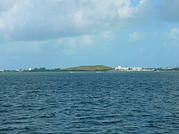
Big Coppitt Key is an island in Monroe County, Florida, United States, in the lower Florida Keys. The name is said to be a derivation of the old English word "coppice", meaning thicket. According to A.D. Bache, in the notes for his coast survey conducted in 1861, this key was the location of Happy Jack's plantation in 1855.

Duck Key is an island in Monroe County, Florida, United States, in the middle Florida Keys. It is part of the Duck Key, Florida census-designated place. The CDP also includes the neighboring island of Conch Key.

The Overseas Highway is a 113-mile (181.9 km) highway carrying U.S. Route 1 (US 1) through the Florida Keys to Key West. Large parts of it were built on the former right-of-way of the Overseas Railroad, the Key West Extension of the Florida East Coast Railway. Completed in 1912, the Overseas Railroad was heavily damaged and partially destroyed in the 1935 Labor Day hurricane. The Florida East Coast Railway was financially unable to rebuild the destroyed sections, so the roadbed and remaining bridges were sold to the state of Florida for $640,000.

Plantation Key is an island in Monroe County, Florida, United States. It is located in the upper Florida Keys on U.S. 1, between Key Largo and Windley Key.
U.S. Highway 1 (US 1) in Florida runs 545 miles (877 km) along the state's east coast from Key West to its crossing of the St. Marys River into Georgia north of Boulogne and south of Folkston. US 1 was designated through Florida when the U.S. Numbered Highway System was established in 1926. With the exception of Monroe County, the highway runs through the easternmost tier of counties in the state, connecting numerous towns and cities along its route, including nine county seats. The road is maintained by the Florida Department of Transportation (FDOT).