Duck Key is a census-designated place and unincorporated community in Monroe County, Florida, United States, on an island of the same name in the middle Florida Keys. The CDP also includes the neighboring island of Conch Key. As of the 2020 census, the CDP had a population of 727, up from 621 in 2010.

Key West is an island in the Straits of Florida, within the U.S. state of Florida. Together with all or parts of the separate islands of Dredgers Key, Fleming Key, Sunset Key, and the northern part of Stock Island, it constitutes the City of Key West.

The Conch Republic is a micronation declared as a tongue-in-cheek secession of the city of Key West, Florida, from the United States on April 23, 1982. It has been maintained as a tourism booster for the city. Since then, the term "Conch Republic" has been expanded to refer to "all of the Florida Keys, or, that geographic apportionment of land that falls within the legally defined boundaries of Monroe County, Florida, northward to 'Skeeter's Last Chance Saloon' in Florida City, Dade County, Florida, with Key West as the micronation's capital and all territories north of Key West being referred to as 'The Northern Territories'".

The Florida Keys are a coral cay archipelago off the southern coast of Florida, forming the southernmost part of the continental United States. They begin at the southeastern coast of the Florida peninsula, about 15 miles (24 km) south of Miami, and extend in a gentle arc south-southwest and then westward to Key West, the westernmost of the inhabited islands, and on to the uninhabited Dry Tortugas. The islands lie along the Florida Straits, dividing the Atlantic Ocean to the east from the Gulf of Mexico to the northwest, and defining one edge of Florida Bay. At the nearest point, the southern part of Key West is just 93 miles (150 km) from Cuba. The Keys are between about 24.3 and 25.5 degrees North latitude.

Duck Key is an island in Monroe County, Florida, United States, in the middle Florida Keys. It is part of the Duck Key, Florida census-designated place. The CDP also includes the neighboring island of Conch Key.

Long Key is an island in the middle Florida Keys. Long Key was called Cayo Víbora by early Spanish explorers, a reference to the shape of the island, which resembles a snake with its jaws open, rather than to its denizens. The city of Layton is located on Long Key. The 965-acre (3.9 km2) state park (3.9 km²) was dedicated October 1, 1969.

The Overseas Highway is a 113-mile (181.9 km) highway carrying U.S. Route 1 (US 1) through the Florida Keys to Key West. Large parts of it were built on the former right-of-way of the Overseas Railroad, the Key West Extension of the Florida East Coast Railway. Completed in 1912, the Overseas Railroad was heavily damaged and partially destroyed in the 1935 Labor Day hurricane. The Florida East Coast Railway was financially unable to rebuild the destroyed sections, so the roadbed and remaining bridges were sold to the state of Florida for $640,000.
Conch was originally a slang term for Bahamians of European descent.

Plantation Key is an island in Monroe County, Florida, United States. It is located in the upper Florida Keys on U.S. 1, between Key Largo and Windley Key.

US 1 crosses the Ohio Key at approximately mile marker 39, between Missouri Key and Bahia Honda Key. Today it is also known as Sunshine Key, after a camping resort located there. The portion of the island south of U.S. Route 1 is protected as the Ohio Key National Wildlife Refuge.

Missouri Key is a small island in the lower Florida Keys.

Little Duck Key is a small island in the lower Florida Keys.

Conch Key is an island and unincorporated community in Monroe County, Florida, United States, located in the middle Florida Keys. U.S. 1 crosses the key at approximately mile markers 62–63, between Long and Duck Keys. It is part of the census-designated place of Duck Key.
Money Key is a small island in Monroe County in the unincorporated, Lower Florida Keys. It is located in the Atlantic Ocean between Little Duck Key and Pigeon Key.
Pigeon Key is a small island containing the historic district of Pigeon Key, Florida. The 5-acre (2.0-hectare) island is home to 8 buildings on the National Register of Historic Places, some of which remain from its earliest incarnation as a work camp for the Florida East Coast Railway. Today these buildings serve a variety of purposes, ranging from housing for educational groups to administrative offices for the non-profit Pigeon Key Foundation. The former Assistant Bridge Tender's House has been converted into a small museum featuring artifacts and images from Pigeon Key's colorful past. It is located off the old Seven Mile Bridge, at approximately mile marker 45, west of Knight's Key, and just east of Moser Channel, which is the deepest section of the 7-mile (11 km) span.

Grassy Key, Florida, is an island in the middle Florida Keys. It is located on U.S. 1, near mile markers 57—60, below the Conch Keys. It has an area of 3.65 km², with a population of 974 as of the census 2000.
Caroline Street is an iconic and historically significant local road on the island of Key West, Florida. It extends approximately 0.5 miles (0.80 km) northeastward to Grinnell Street from Whitehead Street at its southwest end. One of the oldest roads on the island, Caroline Street is surrounded by many old houses, inns, and historic landmarks, which are known for their seclusion from the street by dense landscaping. From its mostly residential origins between Whitehead and Elizabeth streets, Caroline becomes more commercial, punctuated by numerous businesses. Situated within the historic "Old Town" district, Caroline Street was part of the original infrastructural layout of the island at the time of its 1829 mapping by William Whitehead. Other than changes to both its termini, the majority of its route has remained unaltered since then. Caroline Street was named for a sibling of Whitehead; his brother, John, became interested in the island after a shipwreck left him stranded in 1819. The street and some of its surrounding area have been subject to long-term improvement and beautification efforts, beginning chiefly in 1996.
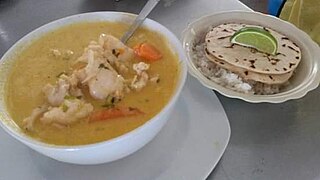
Conch soup and conch chowder are soup dishes made with conch that are traditional in various Caribbean island cuisines as well as the cuisine of Honduras. Conch chowder is also a traditional food of the Florida Keys.

Wilhelmina Celeste Goehring Harvey was a philanthropist and the first female mayor of Monroe County, Florida. A "grand dame of Keys politics", she was frequently a public face of the Conch Republic. Outside of politics, she was a science teacher and scuba diver.