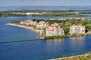
Fisher Island is a census-designated place in Miami-Dade County, Florida, United States, located on a barrier island of the same name. Since 2015, Fisher Island has the highest per capita income of any place in the United States. It is located in the Miami metropolitan area of South Florida. As of the 2020 census, the population was 561.

Islandia is an unincorporated community and former city in Miami-Dade County, Florida, United States. It is located in the upper Florida Keys on the islands of Elliott Key and other nearby keys, such as Totten Key. It was the only municipality in the Florida Keys not located in neighboring Monroe County. The population was 18 at the 2010 Census. Most residents of the city were National Park Service employees.
Key Biscayne is an island village in Miami-Dade County, Florida, United States. The village is part of the Miami metropolitan area of South Florida. The population was 14,809 at the 2020 census, up from 12,344 in 2010.
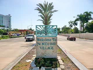
North Bay Village is a city located in Miami-Dade County, Florida. The city is part of the Miami metropolitan area of South Florida. As of the 2020 census, the city had a total population of 8,159.

Biscayne National Park is a national park of the United States located south of Miami, Florida, in Miami-Dade County. The park preserves Biscayne Bay and its offshore barrier reefs. Ninety-five percent of the park is water, and the shore of the bay is the location of an extensive mangrove forest. The park covers 172,971 acres and includes Elliott Key, the park's largest island and northernmost of the true Florida Keys, formed from fossilized coral reef. The islands farther north in the park are transitional islands of coral and sand. The offshore portion of the park includes the northernmost region of the Florida Reef, one of the largest coral reefs in the world.

The Florida Keys are a coral cay archipelago off the southern coast of Florida, forming the southernmost part of the continental United States. They begin at the southeastern coast of the Florida peninsula, about 15 miles (24 km) south of Miami and extend in a gentle arc south-southwest and then westward to Key West, the westernmost of the inhabited islands, and on to the uninhabited Dry Tortugas. The islands lie along the Florida Straits, dividing the Atlantic Ocean to the east from the Gulf of Mexico to the northwest, and defining one edge of Florida Bay. The southern part of Key West is 93 miles (150 km) from Cuba. The Keys are located between about 24.3 and 25.5 degrees North latitude.

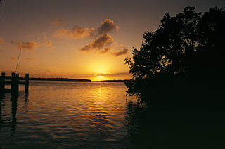
Biscayne Bay is a lagoon with characteristics of an estuary located on the Atlantic coast of South Florida. The northern end of the lagoon is surrounded by the densely developed heart of the Miami metropolitan area while the southern end is largely undeveloped with a large portion of the lagoon included in Biscayne National Park.

Key Biscayne is an island located in Miami-Dade County, Florida, located between the Atlantic Ocean and Biscayne Bay. It is the southernmost of the barrier islands along the Atlantic coast of Florida, and lies south of Miami Beach and southeast of Miami. The key is connected to Miami via the Rickenbacker Causeway, originally built in 1947.

Virginia Key is an 863-acre (3.49 km2) barrier island in Miami, Florida. It is located in Biscayne Bay south of Brickell and north of Key Biscayne and is accessible from the mainland via the Rickenbacker Causeway.

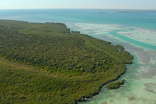
Elliott Key is the northernmost of the true Florida Keys, and the largest key north of Key Largo. It is located entirely within Biscayne National Park, in Miami-Dade County, Florida, east of Homestead, Florida. It is bordered by the Atlantic Ocean to the east, Biscayne Bay to the west, Sands Key to the north, and Old Rhodes Key to the south. Adams Key is just west of the southern end of Elliott Key. Elliott Key is about seven miles (11 km) long. Its maximum width is about 2,500 feet (760 m) near the north end, and its average width is less than 2,000 feet (610 m). The higher elevations on the island range from 6 to 8 feet above sea level and occur generally along an unimproved road that runs longitudinally through the center of the island. The average elevation is about 3 feet (0.91 m) above sea level. The key is accessible only by boat. Elliott Key has a National Park Service campground, but is otherwise uninhabited.

The Rickenbacker Causeway is a causeway that connects Miami, Florida to the barrier islands of Virginia Key and Key Biscayne across Biscayne Bay.

Old Rhodes Key is an island north of the upper Florida Keys in Biscayne National Park. It is in Miami-Dade County, Florida.
Adams Key is an island at the northern part of the upper Florida Keys in Biscayne National Park. It is in Miami-Dade County, Florida. It is located west of the southern tip of Elliott Key, on the north side of Caesar Creek in the lower part of Biscayne Bay. The key is only accessible by boat, and overnight docking is prohibited.

Boca Chita Key is the island north of the upper Florida Keys in Biscayne National Park, Miami-Dade County, Florida.
Ragged Keys are small islands north of the upper Florida Keys.
Soldier Key is an island in Biscayne National Park in Miami-Dade County, Florida. It is located between Biscayne Bay and the Atlantic Ocean, about three miles north of the Ragged Keys, five miles south of Cape Florida on Key Biscayne, seven-and-a-half miles east of the mainland and three miles west of Fowey Rocks. It lies on the Safety Valve, a sand bar that separates Biscayne Bay from the Atlantic Ocean and moderates storm surges into the bay.
Totten Key is an island of the upper Florida Keys in Biscayne National Park. It is in Miami-Dade County, Florida.
Reid Key is a small island north of the upper Florida Keys in Biscayne National Park. It is in Miami-Dade County, Florida.

Meig's Key is a small island north of the upper Florida Keys in Biscayne National Park. It is in Miami-Dade County, Florida.
Caesar's Rock is a small island north of the upper Florida Keys in Biscayne National Park. It is in Miami-Dade County, Florida.

