Key Colony Beach, Florida

Last updated
Key Colony Beach, Florida
MM00038562x (9412452976).jpg
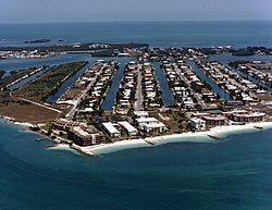
Aerial view of Key Colony Beach, October 1987
Monroe County Florida Incorporated and Unincorporated areas Key Colony Beach Highlighted.svg
Location in Monroe County and the state of Florida
Key Colony Beach.gif
U.S. Census Bureau map showing city limits
Coordinates: 24°43′28″N81°1′5″W / 24.72444°N 81.01806°W / 24.72444; -81.01806
Country Flag of the United States.svg  United States
State Flag of Florida.svg  Florida
County   Monroe
Government
  TypeCommission-Manager
  MayorPatricia Trefry
  Vice MayorBeth Ramsay-Vickrey
  CommissionersThomas Harding, Joey Raspe, Fred Foster
  AdministratorDavid Turner
  Chief of PoliceKris DiGiovanni
Area
[1]
  Total0.65 sq mi (1.68 km2)
  Land0.44 sq mi (1.14 km2)
  Water0.21 sq mi (0.54 km2)
Elevation
3 ft (1 m)
Population
 (2020) [2]
  Total790
  Density1,795.45/sq mi (693.21/km2)
Time zone UTC-5 (Eastern (EST))
  Summer (DST) UTC-4 (EDT)
ZIP code
33051
Area code 305
FIPS code 12-36325 [3]
GNIS feature ID0285076 [4]
Website www.keycolonybeach.net

Key Colony Beach is a municipality in the middle of the Florida Keys, Monroe County, Florida, United States. The population was 790 at the 2020 census. [2]

Contents

History

Before the early 1950s, Shelter Key (on which most of Key Colony Beach is located) was a 97-acre (39-hectare) low-lying island. Then, Phil Sadowski began dredging around the island, adding to its size and increasing its height to 6 feet (1.8 m) above mean sea level, and later built developments on the island.

Around 1956–1957, residents of nearby Marathon began discussing incorporating the entire area. Sadowski was not keen on having his development swallowed up into Marathon, so he began the process of incorporating the island into its own city. The Florida Legislature passed legislation in June 1957 allowing incorporation, which local residents passed unanimously in September, thus creating today's Key Colony Beach.

Incorporation became a blessing in 1960, when much of the city was destroyed by Hurricane Donna. As a separately incorporated city, Key Colony Beach received its own federal grant to rebuild; nearby Marathon (not yet incorporated) had to settle for a portion of the grant given to Monroe County. However, the storm (and then the takeover of Cuba by Fidel Castro) depressed real estate prices, and it took several years to for prices to stabilize. [5]

Geography

Key Colony Beach is located at 24°43′28″N81°1′5″W / 24.72444°N 81.01806°W / 24.72444; -81.01806 (24.724515, –81.017928). [6] Most of the city is located on an island formerly known as Shelter Key; a small part of the city is on Fat Deer Key, where the Sadowski Causeway, the only road entering the city, connects to U.S. 1 (the Overseas Highway) and the city of Marathon, on the east side of the city. Marathon lies to the northwest, north, and northeast of Key Colony Beach, while the Atlantic Ocean is to the south.

Along the Sadowski Causeway are some charter fishing boats and a dockside restaurant called Sparky's Landing. At the south end of the causeway, West Ocean Drive branches off first to the right and East Ocean Drive soon after branches to the left. On West Ocean Drive is the police station, along with the post office and town hall. In the same vicinity is a small park with a fountain and a gazebo. The entire ocean-facing side of West Ocean Drive is lined by various condominium complexes, while the side facing Marathon houses the Key Colony Inn and a par-3 golf course. Starting at the far end of East Ocean Drive, streets are numbered one to fifteen east to west, and run from south to north toward Shelter Bay. The most notable buildings along East Ocean Drive are the Key Colony Beach Motel and the Key Colony Beach Club. At the tip of West Ocean Drive is Sunset Park, the place closest to where a woman was fatally struck by a spotted eagle ray. Many news reports were recorded from this park overlooking the shallows where the Vaca Cut meets the Atlantic Ocean.

According to the United States Census Bureau, the city has a total area of 0.65 square miles (1.7 km2), of which 0.44 square miles (1.1 km2) are land and 0.21 square miles (0.54 km2), or 32.20%, are water. [1]

Demographics

Historical population
CensusPop.Note
1960 66
1970 371462.1%
1980 977163.3%
1990 9770.0%
2000 788−19.3%
2010 7971.1%
2020 790−0.9%
U.S. Decennial Census [7]

2020 census

Key Colony Beach racial composition [8]
RaceNumberPercentage
White (non-Hispanic)64581.65%
Black or African American (non-Hispanic)192.41%
Asian 70.89%
Pacific Islander 10.13%
Other/Mixed 162.03%
Hispanic or Latino 10212.91%

As of the 2020 United States census, there were 790 people, 320 households, and 181 families residing in the city.

2000 census

As of the census [3] of 2000, there were 788 people, 422 households, and 253 families residing in the city. The population density was 1,549.8 inhabitants per square mile (598.4/km2). There were 1,293 housing units at an average density of 2,543.0 per square mile (981.9/km2). The racial makeup of the city was 99.11% White, 0.51% African American, and 0.38% from two or more races. Hispanic or Latino of any race were 4.44% of the population.

There were 422 households, out of which 8.3% had children under the age of 18 living with them, 55.9% were married couples living together, 3.1% had a female householder with no husband present, and 40.0% were non-families. 31.3% of all households were made up of individuals, and 16.4% had someone living alone who was 65 years of age or older. The average household size was 1.87 and the average family size was 2.25.

In the city, the population was spread out, with 7.6% under the age of 18, 3.6% from 18 to 24, 14.3% from 25 to 44, 36.8% from 45 to 64, and 37.7% who were 65 years of age or older. The median age was 58 years. For every 100 females, there were 99.5 males. For every 100 females age 18 and over, there were 96.8 males.

The median income for a household in the city was $45,577, and the median income for a family was $53,750. Males had a median income of $28,654 versus $27,143 for females. The per capita income for the city was $40,631. About 3.9% of families and 7.4% of the population were below the poverty line, including 10.2% of those under age 18 and 3.9% of those age 65 or over.

Education

It is in the Monroe County School District. It is zoned to Stanley Switik Elementary School (K-5) as well as Marathon High School (6-12) in Marathon. [9]

Notable people

Related Research Articles

<span class="mw-page-title-main">Monroe County, Florida</span> County in Florida, United States

Monroe County is a county in the state of Florida. As of the 2020 census, the population was 82,874. Its county seat is Key West. Monroe County includes the islands of the Florida Keys and comprises the Key West Micropolitan Statistical Area. Over 99.9% of the county's population lives on the Florida Keys. The mainland, which is part of the Everglades, comprises 87% of the county's land area and is virtually uninhabited with only 17 people recorded in the 2020 census.

<span class="mw-page-title-main">Indian Harbour Beach, Florida</span> City in Florida

Indian Harbour Beach is a coastal city in Brevard County, Florida, United States. The population was 8,225 at the 2010 United States Census. It is part of the Palm Bay–Melbourne–Titusville Metropolitan Statistical Area. It is 3 miles (4.8 km) north of the town of Indialantic and south of Satellite Beach. It is the first and only community in the United States to be a NOAA Tsunami Ready community along the nation's East Coast.

<span class="mw-page-title-main">South Patrick Shores, Florida</span> CDP in Florida, United States

South Patrick Shores is a census-designated place (CDP) in Brevard County, Florida, United States. The population was 5,875 at the 2010 census. It is part of the Palm Bay–Melbourne–Titusville Metropolitan Statistical Area.

<span class="mw-page-title-main">Manasota Key, Florida</span> Census-designated place in Florida, United States

Manasota Key is a census-designated place (CDP) consisting mainly of the community of Englewood Beach in Charlotte County, Florida, United States. The population of the CDP was 1,326 at the 2020 census. It is part of the Sarasota-Bradenton-Punta Gorda Combined Statistical Area.

<span class="mw-page-title-main">Ocean Breeze, Florida</span> Town in the state of Florida, United States

Ocean Breeze, formerly Ocean Breeze Park, is a town on the Indian River in Martin County, Florida, United States. Ocean Breeze and Briny Breezes in Palm Beach County are the only two towns in Florida in which all residents live in a mobile home park bearing the name of the town. The population was 301 at the 2020 census. The population figures do not include the many part-time winter residents from other places. The town is bordered on three sides by the unincorporated community of Jensen Beach.

<span class="mw-page-title-main">Islandia, Florida</span> Unincorporated community in Florida, United States

Islandia is an unincorporated community and former city in Miami-Dade County, Florida, United States. It is located in the upper Florida Keys on the islands of Elliott Key and other nearby keys, such as Totten Key. It was the only municipality in the Florida Keys not located in neighboring Monroe County. The population was 18 at the 2010 Census. Most residents of the city were National Park Service employees.

<span class="mw-page-title-main">Islamorada, Florida</span> Village of Islands in Florida, United States

Islamorada is an incorporated village in Monroe County, Florida, United States. It is located directly between Miami and Key West on five islands—Tea Table Key, Lower Matecumbe Key, Upper Matecumbe Key, Windley Key and Plantation Key—in the Florida Keys. As of the 2020 census, the village had a population of 7,107, up from 6,119 in 2010.

<span class="mw-page-title-main">Big Pine Key, Florida</span> Census-designated place in Florida, United States

Big Pine Key is a census-designated place and unincorporated community in Monroe County, Florida, United States, on an island of the same name in the Florida Keys. As of the 2020 census, the town had a total population of 4,521.

<span class="mw-page-title-main">Duck Key, Florida</span> Census-designated place in Florida, United States

Duck Key is a census-designated place and unincorporated community in Monroe County, Florida, United States, on an island of the same name in the middle Florida Keys. The CDP also includes the neighboring island of Conch Key. As of the 2020 census, the CDP had a population of 727, up from 621 in 2010.

<span class="mw-page-title-main">Key Largo, Florida</span> Census-designated place in Florida, United States

Key Largo is an unincorporated area and census-designated place in Monroe County, Florida, United States, located on the island of Key Largo in the upper Florida Keys. The population was 12,447 at the 2020 census, up from 10,433 in 2010. The name comes from the Spanish Cayo Largo, or "long key". It is both the first island and town of the Florida Keys to be reached from the Overseas Highway to Key West. It was also the location of one of the stations of the Overseas Railroad.

<span class="mw-page-title-main">Layton, Florida</span> City in Florida, United States

Layton is a city on the island of Long Key in Monroe County, Florida, United States. The population was 210 at the 2020 census.

<span class="mw-page-title-main">Marathon, Florida</span> City in Florida

Marathon is a city in the middle of the Florida Keys, in Monroe County, Florida, United States. As of the 2020 census, the city had a population of 9,689, up from 8,297 in 2010.

<span class="mw-page-title-main">North Key Largo, Florida</span> Census-designated place in Florida, United States

North Key Largo is an unincorporated area and census-designated place (CDP) in Monroe County, Florida, United States. The population was 1,431 at the 2020 census, up from 1,244 in 2010. It includes two private clubs, the Ocean Reef Club and the Key Largo Anglers Club, and is reached from the mainland via the Card Sound Bridge.

<span class="mw-page-title-main">Stock Island, Florida</span> Census-designated place in Florida, United States

Stock Island is a census-designated place (CDP) and unincorporated community on an island of the same name in Monroe County, Florida, United States. The population of the CDP was 4,722 at the 2020 census, up from 3,919 in 2010. It is located on the portion of the island south of US 1. It is supposedly named for the herds of livestock formerly kept there. Alternatively, some local historians suggest that it may be named for an early settler.

<span class="mw-page-title-main">Tavernier, Florida</span> Census-designated place in Florida, United States

Tavernier is a census-designated place (CDP) and unincorporated community in Monroe County, Florida, United States on Key Largo, the largest island in the upper Florida Keys. Tavernier's population was 2,530 at the 2020 census, up from 2,136 in 2010.

<span class="mw-page-title-main">Jupiter Inlet Colony, Florida</span> Town in the state of Florida, United States

Jupiter Inlet Colony is a town in Palm Beach County, Florida, United States. The town was incorporated in 1959 and is part of South Florida's Miami metropolitan area. The population was 405 at the 2020 US census.

<span class="mw-page-title-main">Hutchinson Island South, Florida</span> CDP in Florida, United States

Hutchinson Island South is a census-designated place (CDP) on the barrier island of Hutchinson Island in St. Lucie County, Florida, United States. The South in its name refers to its location in the southern part of St. Lucie County, as it is actually in the central part of the island as a whole. The population was 4,846 at the 2000 census. It is part of the Port St. Lucie Metropolitan Statistical Area. Its mail is delivered from Jensen Beach 34957 in nearby Martin County. The Jensen Beach post office has a postal contract substation known as Hutchinson Beach located at 11007 South Ocean Drive, but it offers only post office boxes and counter services.

<span class="mw-page-title-main">Monroe, Maine</span> Town in the state of Maine, United States

Monroe is a town in Waldo County, Maine, United States named for President James Monroe. The population was 931 at the 2020 census.

<span class="mw-page-title-main">Woodland Beach, Michigan</span> Census-designated place & unincorporated community in Michigan, United States

Woodland Beach is a census-designated place (CDP) and unincorporated community in Monroe County in the U.S. state of Michigan. The population was 1,899 at the 2020 census. The CDP is located within Frenchtown Charter Township.

References

  1. 1 2 "2022 U.S. Gazetteer Files: Florida". United States Census Bureau. Retrieved January 17, 2023.
  2. 1 2 "P1. Race – Key Colony Beach city, Florida: 2020 DEC Redistricting Data (PL 94-171)". U.S. Census Bureau. Retrieved January 17, 2023.
  3. 1 2 "U.S. Census website". United States Census Bureau . Retrieved 2008-01-31.
  4. "US Board on Geographic Names". United States Geological Survey. 2007-10-25. Retrieved 2008-01-31.
  5. Historical Notes on Key Colony Beach
  6. "US Gazetteer files: 2010, 2000, and 1990". United States Census Bureau. 2011-02-12. Retrieved 2011-04-23.
  7. "Census of Population and Housing". Census.gov. Retrieved June 4, 2015.
  8. "Explore Census Data". data.census.gov. Retrieved 2022-01-04.
  9. "Elementary Schools: Boca Chica to Ocean Reef/County Line". Monroe County School District . Retrieved 2022-08-01. - Linked from
  10. Professor of hitting