
Islandia is an unincorporated community and former city in Miami-Dade County, Florida, United States. It is located in the upper Florida Keys on the islands of Elliott Key and other nearby keys, such as Totten Key. It was the only municipality in the Florida Keys not located in neighboring Monroe County. The population was 18 at the 2010 Census. Most residents of the city were National Park Service employees.

Key Biscayne is an island town in Miami-Dade County, Florida, United States. The population was 12,344 at the 2010 census.

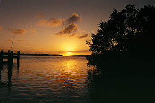
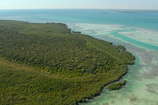
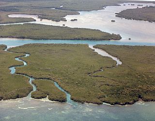
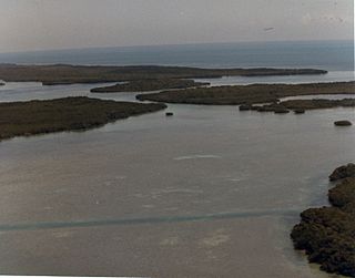
Biscayne National Park is an American national park in southern Florida, south of Miami. The park preserves Biscayne Bay and its offshore barrier reefs. Ninety-five percent of the park is water, and the shore of the bay is the location of an extensive mangrove forest. The park covers 172,971 acres and includes Elliott Key, the park's largest island and northernmost of the true Florida Keys, formed from fossilized coral reef. The islands farther north in the park are transitional islands of coral and sand. The offshore portion of the park includes the northernmost region of the Florida Reef, one of the largest coral reefs in the world.

The Florida Keys are a coral cay archipelago located off the southern coast of Florida, forming the southernmost part of the continental United States. They begin at the southeastern coast of the Florida peninsula, about 15 miles (24 km) south of Miami, and extend in a gentle arc south-southwest and then westward to Key West, the westernmost of the inhabited islands, and on to the uninhabited Dry Tortugas. The islands lie along the Florida Straits, dividing the Atlantic Ocean to the east from the Gulf of Mexico to the northwest, and defining one edge of Florida Bay. At the nearest point, the southern part of Key West is just 90 miles (140 km) from Cuba. The Florida Keys are between about 24.3 and 25.5 degrees North latitude.

Key Biscayne is an island located in Miami-Dade County, Florida, United States, between the Atlantic Ocean and Biscayne Bay. It is the southernmost of the barrier islands along the Atlantic coast of Florida, and lies south of Miami Beach and southeast of Miami. The key is connected to Miami via the Rickenbacker Causeway, originally built in 1947.

Card Sound Bridge is a high-rise toll causeway connecting southern Miami-Dade County and northern Monroe County. It is one of only two ways that motorists can leave or enter the Florida Keys. The toll for two-axle automobiles is USD $1.50 if paid via SunPass. The prior toll plaza was demolished during hurricane Matthew and has been replaced with a toll-by-plate plaza. The toll fee will be charged by plate automatically and sent via the mail to the address on the vehicle registration. The cashless all-electronic tolling system replaced the previous manned toll booth on October 20, 2018. The toll fee is waived upon evacuating the Keys for hurricanes or in instances in which US 1 is impassable.

Elliott Key is the northernmost of the true Florida Keys, and the largest key north of Key Largo. It is located entirely within Biscayne National Park, in Miami-Dade County, Florida, east of Homestead, Florida. It is bordered by the Atlantic Ocean to the east, Biscayne Bay to the west, Sands Key to the north and Old Rhodes Key to the south. Adams Key is just west of the southern end of Elliott Key. Elliott Key is about seven miles (11 km) long. Its maximum width is about 2,500 feet (760 m) near the north end and its average width is less than 2,000 feet (610 m). The higher elevations on the island range from 6 to 8 feet above sea level and occur generally along an unimproved road that runs longitudinally through the center of the island. The average elevation is about 3 feet (0.91 m) above sea level. The key is accessible only by boat. Elliott Key has a National Park Service campground, but is otherwise uninhabited.

Arch Creek was an early settlement in Miami-Dade County, Florida, in present-day metropolitan Miami. Tequesta Indians thrived here before the first Europeans arrived in the early 16th century. The name is derived from the 40 feet (12 m) long natural limestone bridge that spanned the creek until 1973. It is part of the Arch Creek Memorial Park at 1855 Northeast 135th Street, on Biscayne Boulevard. It was added to the U.S. National Register of Historic Places on July 15, 1986.

The Rickenbacker Causeway is a causeway which connects Miami, Florida, United States to the barrier islands of Virginia Key and Key Biscayne across Biscayne Bay.
U.S. Highway 1 (US 1) in Florida runs 545 miles (877 km) along the state's east coast– from Key West to its crossing of the St. Marys River into Georgia north of Boulogne –and south of Folkston. US 1 was designated through Florida when the United States Numbered Highway System was established in 1926. The road is maintained by the Florida Department of Transportation (FDOT).

Old Rhodes Key is an island north of the upper Florida Keys in Biscayne National Park. It is in Miami-Dade County, Florida.
Adams Key is an island north of the upper Florida Keys in Biscayne National Park. It is in Miami-Dade County, Florida. It is located west of the southern tip of Elliott Key, on the north side of Caesar Creek in the lower part of Biscayne Bay. The key is only accessible by boat, and overnight docking is prohibited.
Sands Key is an island north of the upper Florida Keys in Biscayne National Park. It is in Miami-Dade County, Florida.
Ragged Keys are small islands north of the upper Florida Keys.
Totten Key is an island of the upper Florida Keys in Biscayne National Park. It is in Miami-Dade County, Florida.
The Rubicon Keys are two small islands north of the upper Florida Keys in Biscayne National Park. They are in Miami-Dade County, Florida.
Porgy Key is a small island north of the upper Florida Keys in Biscayne National Park. It is in Miami-Dade County, Florida.

Meig's Key is a small island north of the upper Florida Keys in Biscayne National Park. It is in Miami-Dade County, Florida.
Black Caesar Rock is a small island north of the upper Florida Keys in Biscayne National Park. It is in Miami-Dade County, Florida.
Black Caesar was a legendary 18th-century African pirate. The legends say that for nearly a decade, he raided shipping from the Florida Keys and later served as one of Captain Blackbeard's, a.k.a. Edward Teach's, crewmen aboard the Queen Anne's Revenge. He was one of the surviving members of Blackbeard's crew following his death at the hands of Lieutenant Robert Maynard in 1718. Caesar's Rock, one of three islands located north of Key Largo, is named in his honor, and is the present-day site of his original headquarters. However, there is no historical evidence to support Caesar's existence.


