
The east coast of the United States, also known as the Eastern Seaboard, the Atlantic Coast, and the Atlantic Seaboard, is the coastline along which the eastern United States meets the North Atlantic Ocean. Regionally, the term refers to the coastal states and area east of the Appalachian Mountains that have shoreline on the Atlantic Ocean, from north to south, Maine, New Hampshire, Massachusetts, Rhode Island, Connecticut, New York, New Jersey, Delaware, Maryland, Virginia, North Carolina, South Carolina, Georgia and Florida.

Key West is an island in the Straits of Florida, within the U.S. state of Florida. Together with all or parts of the separate islands of Dredgers Key, Fleming Key, Sunset Key, and the northern part of Stock Island, it constitutes the City of Key West.

Marathon is a city spread over Knight's Key, Boot Key, Key Vaca, Fat Deer Key, Long Point Key, Crawl Key and Grassy Key islands in the middle of the Florida Keys, in Monroe County, Florida, United States. As of the 2010 census, the city had a total population of 8,297. As of 2019, the population estimated by the U.S. Census Bureau was 8,581.

The Florida Keys are a coral cay archipelago located off the southern coast of Florida, forming the southernmost part of the continental United States. They begin at the southeastern coast of the Florida peninsula, about 15 miles (24 km) south of Miami, and extend in a gentle arc south-southwest and then westward to Key West, the westernmost of the inhabited islands, and on to the uninhabited Dry Tortugas. The islands lie along the Florida Straits, dividing the Atlantic Ocean to the east from the Gulf of Mexico to the northwest, and defining one edge of Florida Bay. At the nearest point, the southern part of Key West is just 90 miles (140 km) from Cuba. The Florida Keys are between about 24.3 and 25.5 degrees North latitude.

Flight 19 was the designation of a group of five General Motors Eastern Aircraft Division TBM Avenger torpedo bombers that disappeared over the Bermuda Triangle on December 5, 1945, after losing contact during a United States Navy overwater navigation training flight from Naval Air Station Fort Lauderdale, Florida. All 14 airmen on the flight were lost, as were all 13 crew members of a Martin PBM Mariner flying boat that subsequently launched from Naval Air Station Banana River to search for Flight 19. A report by Navy investigators concluded that flight leader Lt. Charles C. Taylor mistook small islands offshore for the Florida Keys after his compasses stopped working, resulting in the flight heading over open sea and away from land. The report was later amended by the Navy to read "cause unknown" to avoid blaming Taylor for the loss of 5 aircraft and 14 men. The report attributed the loss of the PBM aircraft to an explosion in mid-air while searching for the flight.

Dry Tortugas National Park is a national park in the United States about 68 miles (109 km) west of Key West in the Gulf of Mexico. The park preserves Fort Jefferson and the seven Dry Tortugas islands, the westernmost and most isolated of the Florida Keys. The archipelago's coral reefs are the least disturbed of the Florida Keys reefs.
The Overseas Highway is a 113-mile (181.9 km) highway carrying U.S. Route 1 (US 1) through the Florida Keys to Key West. Large parts of it were built on the former right-of-way of the Overseas Railroad, the Key West Extension of the Florida East Coast Railway. Completed in 1912, the Overseas Railroad was heavily damaged and partially destroyed in the 1935 Labor Day hurricane. The Florida East Coast Railway was financially unable to rebuild the destroyed sections, so the roadbed and remaining bridges were sold to the state of Florida for $640,000.
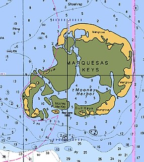
The Marquesas Keys form an uninhabited island group about 20 miles (32 km) west of Key West, four miles (6 km) in diameter, and largely covered by mangrove forest. They are an unincorporated area of Monroe County, Florida and belong to the Lower Keys Census County Division. They are protected as part of the Key West National Wildlife Refuge. The Marquesas were used for target practice by the military as recently as 1980.

Gulf Islands National Seashore offers recreation opportunities and preserves natural and historic resources along the Gulf of Mexico barrier islands of Florida and Mississippi. The protected regions include mainland areas and parts of seven islands. Some islands along the Alabama coast were originally considered for inclusion, but none are part of the National Seashore.

Boca Chica Key is an island in the lower Florida Keys, about a mile east of the island of Key West at its closest point. Its name is Spanish for "small mouth". It is mostly covered by salt marshes and mangrove trees, and is the home of the largest Naval Air Station in south Florida. U.S. 1, the Overseas Highway, crosses the key at approximately mile markers 6.5—8, east of Key West., near the NAS and Boca Chica Beach on Boca Chica Road.

Stock Island is an island in the lower Florida Keys immediately east of Key West. Immediately northwest is Key Haven, from which it is connected by causeway with US 1. The part north of U.S. 1 is part of the City of Key West, while the southern part is a census-designated place (CDP) in Monroe County, Florida, United States. The population of the CDP was 4,410 at the 2000 census. Stock Island was supposedly named for herds of livestock formerly kept there. Alternatively, some local historians suggest that it may be named for an early settler.

Egmont Key State Park and National Wildlife Refuge is a Florida State Park located on the island of Egmont Key, at the mouth of Tampa Bay. Egmont Key lies southwest of Fort De Soto Park and can only be reached by boat or ferry. Located within Egmont Key State Park are the 1858 Egmont Key Lighthouse, maintained by the U.S. Coast Guard, and the ruins of Fort Dade, a Spanish–American War era fort that housed 300 residents. Egmont Key is located in Hillsborough County Florida on a narrow strip of the county that extends along the Tampa Port Shipping Channel.

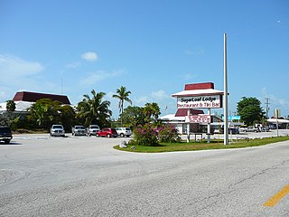
Sugarloaf Key is a single island in the lower Florida Keys that forms a loop on the Atlantic Ocean side giving the illusion of separate islands. Although frequently referred to simply and with technical accuracy as "Sugarloaf Key", this island contains two distinct island communities, known as Lower Sugarloaf Key and Upper Sugarloaf Key.
Bahia Honda is an island in the lower Florida Keys.
Lower Sugarloaf Key is the lower arm of an island known as Sugarloaf Key in the lower Florida Keys about 13 miles east of Key West.
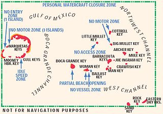
The Mule Keys, also named Barracouta Keys by the US Fish and Wildlife Service, are a group of scattered islets in the Florida Keys in Monroe County, Florida, United States. They are between 3 and 12 mi west of Key West, separated from it by the Northwest Channel. On the west, they are separated from the Marquesas Keys by the 6-mile (9.7 km) wide Boca Grande Channel. They belong to the outlying islands of the Florida Keys. Administratively, they are an unincorporated area of Monroe County. The islets are part of the Key West National Wildlife Refuge. The area of the islets totals 1.07 sq mi (2.8 km2), of which 1.02 sq mi (2.6 km2) are land area and 0.05 sq mi (0.13 km2) inland water bodies. The islets are uninhabited except for Mule Key, for which the census of 2000 lists one housing unit with a population of two.

Trumbo Point is a section of the northwest corner of the island of Key West, Florida in the lower Florida Keys. It is one of several bases comprising the Key West Naval Air Station.

Pigeon Key is a small island containing the historic district of Pigeon Key, Florida. The 5-acre (2.0-hectare) island is home to 8 buildings on the National Register of Historic Places, some of which remain from its earliest incarnation as a work camp for the Florida East Coast Railway. Today these buildings serve a variety of purposes, ranging from housing for educational groups to administrative offices for the non-profit Pigeon Key Foundation. The former Assistant Bridge Tender's House has been converted into a small museum featuring artifacts and images from Pigeon Key's colorful past. It is located off the old Seven Mile Bridge, at approximately mile marker 45, west of Knight's Key, and just east of Moser Channel, which is the deepest section of the 7-mile (11 km) span.
Archer Key is an island in the Florida Keys in Monroe County, Florida, United States. It is within the boundaries of the Key West National Wildlife Refuge.

Woman Key is an island in the Florida Keys in Monroe County, Florida, United States. It is within the boundaries of the Key West National Wildlife Refuge.

