Islandia is an unincorporated community and former city in Miami-Dade County, Florida, United States. It is located in the upper Florida Keys on the islands of Elliott Key and other nearby keys, such as Totten Key. It was the only municipality in the Florida Keys not located in neighboring Monroe County. The population was 18 at the 2010 Census. Most residents of the city were National Park Service employees.

Key Biscayne is an island town in Miami-Dade County, Florida, United States. The population was 12,344 at the 2010 census.

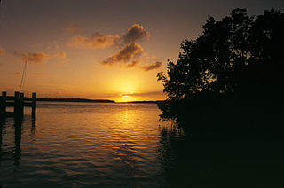
Key Biscayne is an island located in Miami-Dade County, Florida, United States, between the Atlantic Ocean and Biscayne Bay. It is the southernmost of the barrier islands along the Atlantic coast of Florida, and lies south of Miami Beach and southeast of Miami. The key is connected to Miami via the Rickenbacker Causeway, originally built in 1947.

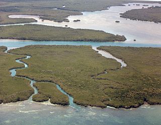
Elliott Key is the northernmost of the true Florida Keys, and the largest key north of Key Largo. It is located entirely within Biscayne National Park, in Miami-Dade County, Florida, east of Homestead, Florida. It is bordered by the Atlantic Ocean to the east, Biscayne Bay to the west, Sands Key to the north and Old Rhodes Key to the south. Adams Key is just west of the southern end of Elliott Key. Elliott Key is about seven miles (11 km) long. Its maximum width is about 2,500 feet (760 m) near the north end and its average width is less than 2,000 feet (610 m). The higher elevations on the island range from 6 to 8 feet above sea level and occur generally along an unimproved road that runs longitudinally through the center of the island. The average elevation is about 3 feet (0.91 m) above sea level. The key is accessible only by boat. Elliott Key has a National Park Service campground, but is otherwise uninhabited.

The Cape Florida Light is a lighthouse on Cape Florida at the south end of Key Biscayne in Miami-Dade County, Florida. Constructed in 1825, it guided mariners off the Florida Reef, which starts near Key Biscayne and extends southward a few miles offshore of the Florida Keys. It was operated by staff, with interruptions, until 1878, when it was replaced by the Fowey Rocks lighthouse. The lighthouse was put back into use in 1978 by the U.S. Coast Guard to mark the Florida Channel, the deepest natural channel into Biscayne Bay. They decommissioned it in 1990.

Fowey Rocks Light is located seven miles southeast of Cape Florida on Key Biscayne. The lighthouse was completed in 1878, replacing the Cape Florida Light. It was automated on May 7, 1975 and is still in operation today. The structure is cast iron, with a screw-pile foundation, a platform and a skeletal tower. The light is 110 feet above the water. The tower framework is painted brown, while the dwelling and enclosed circular stair to the lantern is painted white. The original lens was a first-order drum Fresnel lens which stood about 12 feet (4 m) high and weighed about a ton (tonne). The light has a nominal range of 15 miles in the white sectors, and 10 miles in the red sectors.
Adams Key is an island north of the upper Florida Keys in Biscayne National Park. It is in Miami-Dade County, Florida. It is located west of the southern tip of Elliott Key, on the north side of Caesar Creek in the lower part of Biscayne Bay. The key is only accessible by boat, and overnight docking is prohibited.
Soldier Key is an island in Biscayne National Park in Miami-Dade County, Florida. It is located between Biscayne Bay and the Atlantic Ocean, about three miles north of the Ragged Keys, five miles south of Cape Florida on Key Biscayne, seven-and-a-half miles east of the mainland and three miles west of Fowey Rocks. It lies on the Safety Valve, a sand bar that separates Biscayne Bay from the Atlantic Ocean and moderates storm surges into the bay.
The Rubicon Keys are two small islands north of the upper Florida Keys in Biscayne National Park. They are in Miami-Dade County, Florida.
Reid Key is a small island north of the upper Florida Keys in Biscayne National Park. It is in Miami-Dade County, Florida.
Porgy Key is a small island north of the upper Florida Keys in Biscayne National Park. It is in Miami-Dade County, Florida.

Meig's Key is a small island north of the upper Florida Keys in Biscayne National Park. It is in Miami-Dade County, Florida.
Black Caesar Rock is a small island north of the upper Florida Keys in Biscayne National Park. It is in Miami-Dade County, Florida.
Coral Reef Drive, also known as South 152nd Street, is a 9.6-mile-long (15.4 km) main east–west road south south of Miami in Miami-Dade County, Florida, United States. It serves to connect the communities of Country Walk and Richmond Heights with Palmetto Bay. State Road 992 is designated along the 2.462-mile-long (3.962 km) section of Coral Reef Drive between the Homestead Extension of Florida's Turnpike and US 1.

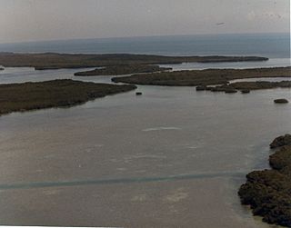
The Florida Reef is the only living coral barrier reef in the continental United States. It is the third largest coral barrier reef system in the world. It lies a few miles seaward of the Florida Keys, is about 4 miles wide and extends 270 km (170 mi) from Fowey Rocks just east of Soldier Key to just south of the Marquesas Keys. The barrier reef tract forms a great arc, concentric with the Florida Keys, with the northern end, in Biscayne National Park, oriented north-south and the western end, south of the Marquesas Keys, oriented east-west. The rest of the reef outside Biscayne National Park lies within John Pennekamp Coral Reef State Park and the Florida Keys National Marine Sanctuary. Isolated coral patch reefs occur northward from Biscayne National Park as far north as Stuart, in Martin County. Coral reefs are also found in Dry Tortugas National Park west of the Marquesas Keys. There are more than 6,000 individual reefs in the system. The reefs are 5,000 to 7,000 years old, having developed since sea levels rose following the Wisconsinan glaciation.
The Biscayne Bay Yacht Club is a private yacht club located in Coconut Grove, Miami. Founded in 1887 by Commodore Ralph Middleton Munroe, the Biscayne Bay Yacht Club is one of the oldest yacht clubs in Florida.