
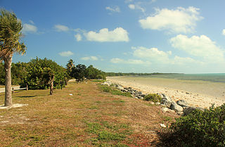
Big Pine Key is a census-designated place and unincorporated community in Monroe County, Florida, United States, on an island of the same name in the Florida Keys. As of the 2020 census, the town had a total population of 4,521.

Flamingo is the southernmost headquarters of Everglades National Park, in Monroe County, Florida, United States. Flamingo is one of the two end points of the 99-mile (159-km) Wilderness Waterway, and the southern end of the only road through the park from Florida City. It began as a small coastal settlement on the eastern end of Cape Sable on the southern tip of the Florida peninsula, facing Florida Bay. The actual town of Flamingo was located approximately 4+1⁄2 miles west of the current Flamingo campground area. All that remains of the former town are a few remnants of building foundations, and it is considered a ghost town.

The Florida Keys are a coral cay archipelago off the southern coast of Florida, forming the southernmost part of the continental United States. They begin at the southeastern coast of the Florida peninsula, about 15 miles (24 km) south of Miami and extend in a gentle arc south-southwest and then westward to Key West, the westernmost of the inhabited islands, and on to the uninhabited Dry Tortugas. The islands lie along the Florida Straits, dividing the Atlantic Ocean to the east from the Gulf of Mexico to the northwest, and defining one edge of Florida Bay. The southern part of Key West is 93 miles (150 km) from Cuba. The Keys are located between about 24.3 and 25.5 degrees North latitude.

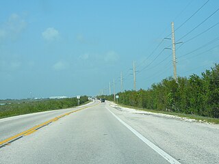
The Overseas Highway is a 113-mile (181.9 km) highway carrying U.S. Route 1 (US 1) through the Florida Keys to Key West. Large parts of it were built on the former right-of-way of the Overseas Railroad, the Key West Extension of the Florida East Coast Railway. Completed in 1912, the Overseas Railroad was heavily damaged and partially destroyed in the 1935 Labor Day hurricane. The Florida East Coast Railway was financially unable to rebuild the destroyed sections, so the roadbed and remaining bridges were sold to the state of Florida for $640,000.

The Saddlebunch Keys are a series of mangrove islands about 7 miles (11 km) east of Key West, Florida.

No Name Key is an island in the lower Florida Keys in the United States. It is 3 miles (4.8 km) from US 1 and sparsely populated, with only 43 homes. It is only about 1,140 acres in comparison to its larger neighbor, Big Pine Key, which lies about half a mile (800 m) to its west. It is accessible by a concrete bridge from Big Pine Key and was the terminus of a car ferry that existed before the present Overseas Highway was built on the remains of Flagler's Overseas Railroad.

Elliott Key is the northernmost of the true Florida Keys, and the largest key north of Key Largo. It is located entirely within Biscayne National Park, in Miami-Dade County, Florida, east of Homestead, Florida. It is bordered by the Atlantic Ocean to the east, Biscayne Bay to the west, Sands Key to the north, and Old Rhodes Key to the south. Adams Key is just west of the southern end of Elliott Key. Elliott Key is about seven miles (11 km) long. Its maximum width is about 2,500 feet (760 m) near the north end, and its average width is less than 2,000 feet (610 m). The higher elevations on the island range from 6 to 8 feet above sea level and occur generally along an unimproved road that runs longitudinally through the center of the island. The average elevation is about 3 feet (0.91 m) above sea level. The key is accessible only by boat. Elliott Key has a National Park Service campground, but is otherwise uninhabited.
Lignumvitae Key Botanical State Park is a Florida State Park consisting of Lignumvitae Key, Shell Key, surrounding submerged lands, and a parcel at the northern end of Lower Matecumbe Key. The islands are located one mile west of U.S. 1 at mile marker 78.5, and can be reached only by private boat or tour boat.
Long Key State Park is a 965-acre (3.91 km2) Florida State Park located on Long Key, one of the Florida Keys, in Monroe County, Florida, United States. It is at mile marker 67.5 on U.S. 1, 67400 Overseas Highway.

Plantation Key is an island in Monroe County, Florida, United States. It is located in the upper Florida Keys on U.S. 1, between Key Largo and Windley Key.
Park Key is an uninhabited island in the lower Florida Keys about 14 miles (23 km) east of Key West. It is 1500 Meters long, and between 75 and 260 Meters wide. It measures 70 acres in area.

Ramrod Key is an island in the lower Florida Keys. Originally named Roberts Island, Ramrod Key was renamed for a ship named Ramrod, which was wrecked on a reef south of there in the early nineteenth century.
Bahia Honda is an island in the lower Florida Keys.
Lower Sugarloaf Key is the lower arm of an island known as Sugarloaf Key in the lower Florida Keys about 13 miles (21 km) east of Key West.
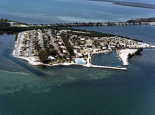
Fiesta Key is an island in the Florida Keys, connected via causeway to U.S. 1 at mile marker 70, between Long Key and Craig Key.

Perky is a ghost town in Monroe County, Florida, United States. It is located in the lower Florida Keys on Lower Sugarloaf Key near mile marker 17 on US 1.

The Bahia Honda Rail Bridge is a derelict railroad bridge in the lower Florida Keys connecting Bahia Honda Key with Spanish Harbor Key. It was originally part of the Overseas Railway, but the state of Florida purchased it from the Florida East Coast Railway (FEC) after the 1935 Labor Day Hurricane and converted it for automobile use as part of the Overseas Highway in 1938. After a replacement Bahia Honda Bridge was opened in 1972, two spans of the old bridge were removed for the safety of boat traffic and to prevent pedestrian access to unsafe parts of the bridge.
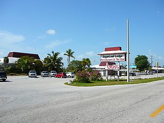
Sugarloaf Shores is an unincorporated community in Monroe County, Florida, United States, located in the lower Florida Keys on Lower Sugarloaf Key near mile marker 17 on US 1.

Upper Sugarloaf Key is located in the Florida Keys. It located between MM20.5-MM19 and bridge number 28/29 at Bow Channel/Park Key. U.S. 1 crosses the key at approximately mile markers 19–20.5. Upper Sugarloaf Key is located about 15 miles east of Key West, between Park Key and Cudjoe Key. It is the upper arm of a large island, Sugarloaf Key, that includes Lower Sugarloaf Key.

Grassy Key, Florida, is an island in the middle Florida Keys. It is located on U.S. 1, near mile markers 57—60, below the Conch Keys. It has an area of 3.65 km², with a population of 974 as of the census 2000.


