Bahia Honda Rail Bridge

Last updated
Bahia Honda Rail Bridge
Overseas Railroad.jpg
View of the Bahia Honda Bridge from Bahia Honda State Park.
Coordinates 24°39′19″N81°17′33″W / 24.65520°N 81.29253°W / 24.65520; -81.29253
CarriesSingle track of Florida East Coast Railway, North and Southbound lanes of U.S. Route 1
Crosses Bahia Honda Channel [1]
LocaleConnects Bahia Honda Key and Spanish Harbor Key
Characteristics
Design Parker (Camelback) Truss Bridge with Pratt Truss and Plate Girder approaches [2]
Total length5,055 feet (1,541 m)
Longest span247 feet (75 m)
History
Opened1912 as rail bridge, converted to highway use in 1938
Closed1972
Location
Bahia Honda Rail Bridge

The Bahia Honda Rail Bridge is a derelict railroad bridge in the lower Florida Keys connecting Bahia Honda Key with Spanish Harbor Key. It was originally part of the Overseas Railway, but the state of Florida purchased it from the Florida East Coast Railway (FEC) after the 1935 Labor Day Hurricane and converted it for automobile use as part of the Overseas Highway in 1938. [3] After a replacement Bahia Honda Bridge was opened in 1972, [2] two spans of the old bridge were removed for the safety of boat traffic and to prevent pedestrian access to unsafe parts of the bridge.

Contents

History

Bahia Honda Bridge during railroad operation (before highway conversion) Bahia Honda Bridge before conversion.jpg
Bahia Honda Bridge during railroad operation (before highway conversion)
Postcard of the bridge during operation for highway use. Bahia Honda Bridge, highest span of Overseas Highway on way to Key West, Florida.jpg
Postcard of the bridge during operation for highway use.

The Bahia Honda railroad bridge was originally built by Henry Flagler as part of the FEC's Overseas Railroad. Opened in 1912, Flagler funded the railway construction between Miami and Key West using his own personal funds. [3] The Labor Day Hurricane of 1935 destroyed much of the line, and FEC sought abandonment. It was purchased by the state of Florida and converted for highway use in 1938. [4] Rather than rebuilding the bridge, the top of the structure was redecked for use as the Overseas Highway (the existing deck inside the truss was too narrow for vehicular traffic).

A new four-lane bridge was built and opened in 1972, a few hundred yards north of the old bridge, [4] replacing the former route of U.S. 1. Two of the truss spans have been removed. One near the east end to allow boat traffic to pass through Bahia Honda Channel without the danger of falling debris from the old bridge; the other at the westernmost end to prevent pedestrians from accessing unsafe parts of the bridge. It is a misconception the trusses were removed in order to facilitate traffic for boats needing higher vertical clearance, as the new bridge has roughly the same vertical clearance of about 20 feet (6.1 m). [5] [6] The original bridge has fallen into a state of disrepair; signs have been posted on the bridge warning boat traffic to watch for falling debris, but all of the sections have remained standing (not counting the two that were removed). The easternmost section remains open to pedestrian traffic and is maintained by Bahia Honda State Park. The bridge provides a scenic overview of the area for tourists.

Structural design

Before being reused as a highway bridge, the Bahia Honda Rail Bridge carried a single track of FEC across Big Spanish Channel from Bahia Honda Key to Spanish Harbor Key. Unlike other bridges on the Overseas Railway, the Bahia Honda has a steel truss construction. [3] This was a necessary difference from the predominant concrete arch form of the other bridges [2] of the Overseas Railroad, as the channel is the deepest of those spanned, at 24 feet (7.3 m). [1] The central span is a Parker truss with a span of 247 feet (75 m). This is surrounded by 13 Pratt truss sections spanning 186 feet (57 m) on either side, and 13 smaller Pratt trusses each spanning 128 feet (39 m) outside those. Nine plate girder sections were used for the western approach, for a total length of 5,055 feet (1,541 m). The smaller Pratt trusses have riveted connections, but the larger Pratt and Parker trusses use pinned connections, making the Bahia Honda Rail Bridge the longest pin-connected truss bridge in the U.S. [2]

The original construction of the bridge was carried out by William Krome and Joseph Meredith, and the vehicular conversion was undertaken by B.M. Duncan. [2]

See also

Related Research Articles

<span class="mw-page-title-main">Florida Keys</span> Coral cay archipelago in Florida, United States

The Florida Keys are a coral cay archipelago off the southern coast of Florida, forming the southernmost part of the continental United States. They begin at the southeastern coast of the Florida peninsula, about 15 miles (24 km) south of Miami, and extend in a gentle arc south-southwest and then westward to Key West, the westernmost of the inhabited islands, and on to the uninhabited Dry Tortugas. The islands lie along the Florida Straits, dividing the Atlantic Ocean to the east from the Gulf of Mexico to the northwest, and defining one edge of Florida Bay. At the nearest point, the southern part of Key West is just 93 miles (150 km) from Cuba. The Keys are between about 24.3 and 25.5 degrees North latitude.

<span class="mw-page-title-main">Swing bridge</span> Bridge which pivots around the mid-point

A swing bridge is a movable bridge that has as its primary structural support a vertical locating pin and support ring, usually at or near to its center of gravity, about which the swing span can then pivot horizontally as shown in the animated illustration to the right. Small swing bridges as found over canals may be pivoted only at one end, opening as would a gate, but require substantial underground structure to support the pivot.

<span class="mw-page-title-main">14th Street bridges</span> 3 bridges across the Potomac River connecting Arlington, VA and Washington, D.C., USA

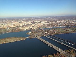
The 14th Street bridges refers to the three bridges near each other that cross the Potomac River, connecting Arlington, Virginia and Washington, D.C. Sometimes the two nearby rail bridges are included as part of the 14th Street bridge complex. A major gateway for automotive, bicycle and rail traffic, the bridge complex is named for 14th Street, which feeds automotive traffic into it on the D.C. end.

<span class="mw-page-title-main">Florida East Coast Railway</span> Class II railroad operating in Florida

The Florida East Coast Railway is a Class II railroad operating in the U.S. state of Florida, currently owned by Grupo México.

<span class="mw-page-title-main">Truss bridge</span> Bridge whose load-bearing superstructure is composed of a truss

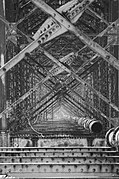
A truss bridge is a bridge whose load-bearing superstructure is composed of a truss, a structure of connected elements, usually forming triangular units. The connected elements may be stressed from tension, compression, or sometimes both in response to dynamic loads. The basic types of truss bridges shown in this article have simple designs which could be easily analyzed by 19th and early 20th-century engineers. A truss bridge is economical to construct because it uses materials efficiently.

<span class="mw-page-title-main">Seven Mile Bridge</span> Bridge in Florida, United States of America

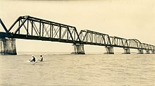
The Seven Mile Bridge is a bridge in the Florida Keys, in Monroe County, Florida, United States. It connects Knight's Key in the Middle Keys to Little Duck Key in the Lower Keys. Among the longest bridges in existence when it was built, it is part of the Overseas Highway in the Keys, which is part of the 2,369-mile (3,813 km) U.S. Route 1.

<span class="mw-page-title-main">Overseas Highway</span> Highway through the Florida Keys to Key West, Florida, USA

The Overseas Highway is a 113-mile (181.9 km) highway carrying U.S. Route 1 (US 1) through the Florida Keys to Key West. Large parts of it were built on the former right-of-way of the Overseas Railroad, the Key West Extension of the Florida East Coast Railway. Completed in 1912, the Overseas Railroad was heavily damaged and partially destroyed in the 1935 Labor Day hurricane. The Florida East Coast Railway was financially unable to rebuild the destroyed sections, so the roadbed and remaining bridges were sold to the state of Florida for $640,000.

<span class="mw-page-title-main">Huey P. Long Bridge (Jefferson Parish)</span> Road and railroad bridge in Louisiana, U.S.

The Huey P. Long Bridge, located in Jefferson Parish, Louisiana, is a cantilevered steel through-truss bridge that carries a two-track railroad line over the Mississippi River at mile 106.1, with three lanes of US 90 on each side of the central tracks. It is several kilometers upriver from the city of New Orleans. The East Bank entrance is at Elmwood, Louisiana, and the West Bank at Bridge City.

<span class="mw-page-title-main">Industrial Canal</span> Canal in Louisiana, United States of America

The Industrial Canal is a 5.5 mile (9 km) waterway in New Orleans, Louisiana, United States. The waterway's proper name, as used by the U.S. Army Corps of Engineers and on NOAA nautical charts, is Inner Harbor Navigation Canal (IHNC). The more common "Industrial Canal" name is used locally, both by commercial mariners and by landside residents.

<span class="mw-page-title-main">Overseas Railroad</span> Former railroad in southern Florida, United States

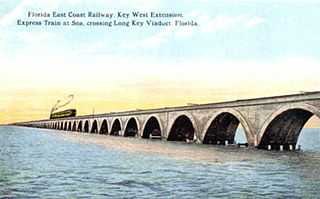
The Overseas Railroad was an extension of the Florida East Coast Railway to Key West, a city located 128 miles (206 km) beyond the end of the Florida peninsula. Work on the line started in 1905 and it operated from 1912 to 1935, when it was partially destroyed by the Labor Day Hurricane. Some of the remaining infrastructure was used for the Overseas Highway.

<span class="mw-page-title-main">International Railway Bridge</span> Bridge in Ontario and Buffalo, New York

The International Railway Bridge is a two-span swing bridge carrying the Stamford Subdivision of the Canadian National Railway across the Niagara River between Fort Erie, Ontario, Canada, and Buffalo, New York, United States. It was originally built in 1873 for the International Bridge Company by Casimir Stanislaus Gzowski and D.L. MacPherson.

<span class="mw-page-title-main">Quincy Rail Bridge</span> Bridge in Missouri and Quincy, Illinois

The Quincy Rail Bridge is a truss bridge that carries a rail line across the Mississippi River between West Quincy, Missouri, and Quincy, Illinois, USA. It was originally constructed in 1868 for the Chicago, Burlington and Quincy Railroad, a predecessor of BNSF Railway.

<span class="mw-page-title-main">Bahia Honda Key</span> Island in Florida, United States

Bahia Honda is an island in the lower Florida Keys.

Pigeon Key is a small island containing the historic district of Pigeon Key, Florida. The 5-acre (2.0-hectare) island is home to 8 buildings on the National Register of Historic Places, some of which remain from its earliest incarnation as a work camp for the Florida East Coast Railway. Today these buildings serve a variety of purposes, ranging from housing for educational groups to administrative offices for the non-profit Pigeon Key Foundation. The former Assistant Bridge Tender's House has been converted into a small museum featuring artifacts and images from Pigeon Key's colorful past. It is located off the old Seven Mile Bridge, at approximately mile marker 45, west of Knight's Key, and just east of Moser Channel, which is the deepest section of the 7-mile (11 km) span.

The Florida Keys Overseas Heritage Trail is a 106-mile (171 km) paved rail trail—a multi-use bicycle and pedestrian facility—being constructed between Key Largo and Key West in the Florida Keys. As of January 2022, 90 mi (140 km) of the trail has been constructed.

<span class="mw-page-title-main">Sadliers Crossing Railway Bridge</span> Historic site in Queensland, Australia

Sadliers Crossing Railway Bridge is a heritage-listed railway bridge at over Bremer River between Tallon Street, Sadliers Crossing and Dixon Street, Wulkuraka, Queensland, Australia on the Main Line (this section is now the Ipswich and Rosewood railway line. It was added to the Queensland Heritage Register on 13 November 2008.

<span class="mw-page-title-main">Long Key Bridge</span> Bridge in Florida, United States of America

The Long Key Bridge, officially known as the Dante B. Fascell Bridge, is a bridge in the Florida Keys connecting Long Key and Conch Key, roughly halfway between Miami and Key West. At a length of nearly two and a half miles, it is the second longest bridge on the Overseas Highway after the Seven Mile Bridge. The current bridge opened in 1982, replacing the parallel Long Key Viaduct, which carried the Overseas Railroad from 1907 to 1935 and was repurposed for highway use shortly after.

Clarence Stanley Coe was an American master bridge builder and railroad civil engineer, who supervised the planning and building of the Florida East Coast Railway's Seven Mile Bridge, linking the Florida Keys to Marathon, Monroe County, which, when completed in January 1912, was acclaimed as the longest bridge in the world and an engineering marvel. Later, Coe was appointed the first city manager of Miami, Florida, and after that was appointed chief engineer of Duval County, Florida.

<span class="mw-page-title-main">Gould's Mill Bridge</span> United States historic place

The Gould's Mill Bridge is a historic Baltimore through truss bridge, carrying Paddock Street across the Black River in Springfield, Vermont. The bridge was built by the Boston Bridge Works Company in 1929 after major flooding in 1927, and is one of the state's few examples of a Baltimore truss. It was listed on the National Register of Historic Places in 2006.

References

  1. 1 2 Chart 11445 Intracoastal Waterway Bahia Honda Key to Sugarloaf Key, National Oceanographic and Atmospheric Administration, Office of Coast Survey. (2012). Intracoastal Waterway Bahia Honda Key to Sugarloaf Key (Chart No. 11445). Retrieved from website: http://www.charts.noaa.gov/OnLineViewer/11445.shtml
  2. 1 2 3 4 5 BridgeMapper.com, Bridge Mapper. (2011). Old Bahia Honda Channel bridge. Retrieved from http://www.bridgemapper.com/bridge_detail.php?ID=619 Archived 2013-12-30 at the Wayback Machine
  3. 1 2 3 KeysHistory.org, Wilkinson, J. History of the overseas highway. Retrieved from http://www.keyshistory.org/osh.html
  4. 1 2 , Collingwood Publications. (2010). Bahia Honda State Park. Retrieved from http://www.key-largo-sunsets.com/bahia-honda.html Archived 2012-03-21 at the Wayback Machine
  5. "BAHIA HONDA KEY TO SUGARLOAF KEY (Marine Chart : US11445_P329)". GPS Nautical Charts. Retrieved 31 May 2020.
  6. "Boating in Bahia Honda Key, Bahia Honda Channel, FL". US Harbors. Retrieved 31 May 2020.