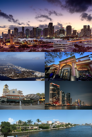
The Miami metropolitan area is a coastal metropolitan area in southeastern Florida. It is the ninth-largest metropolitan statistical area (MSA) in the United States, the fifth-largest metropolitan area in the Southern United States, and the largest metropolitan area in Florida. It is also known as South Florida, SoFlo, SoFla, the Gold Coast, Southeast Florida, the Tri-County Area, or Greater Miami, and officially as the Miami–Fort Lauderdale–West Palm Beach Metropolitan Statistical Area. With a population of 6.18 million, its population exceeds 31 of the nation's 50 states as of 2023. It comprises the three most populated counties in the state, Miami-Dade County, Broward County, and Palm Beach County, which rank as the first, second, and third-most populous counties in the state, respectively. Miami-Dade County, with 2,701,767 people in 2020, is the seventh-most populous county in the United States.

State Road A1A (SR A1A) is a major north–south Florida State Road consisting of seven separate sections running a total of 338.752 miles (545.168 km) along the Atlantic Ocean, from Key West at the southern tip of Florida, to Fernandina Beach, just south of Georgia on Amelia Island. It is the main road through most oceanfront towns. Part of SR A1A is designated the A1A Scenic and Historic Coastal Byway, a National Scenic Byway. SR A1A is famous worldwide as a center of beach culture in the United States, a scenic coastal route through most Atlantic coastal cities and beach towns, including the unique tropical coral islands of the Florida Keys. SR A1A also serves as a major thoroughfare through Miami Beach and other south Florida coastal cities.
The Millionaires' Mile, Millionaires' Row, Billionaires' Row, Golden Mile or Alpha Street are the exclusive residential neighborhoods of various cities, often along one scenic strip such as a riverside or hilltop drive, or a wide city boulevard.
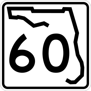
State Road 60, or Route 60 is an east–west route transversing Florida from the Gulf of Mexico to the Atlantic Ocean. The western terminus of SR 60 is at the Sunsets at Pier 60 site in Clearwater Beach. The eastern terminus is in Vero Beach near the Atlantic Coast just past State Road A1A.

State Road 80 is a 123.5 miles (198.8 km) route linking US 41 Business in Fort Myers and State Road A1A in Palm Beach. The road is the northernmost of three linking Southwest Florida to South Florida via the Everglades. Due to increasing traffic, State Road 80 has experienced upgrades and widening in various sections since 2000.
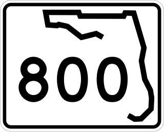
Spanish River Boulevard is a short east–west highway in Boca Raton, Palm Beach County, Florida. The eastern 0.5 miles (0.80 km) is signed as State Road 800 (SR 800), though the western segment was formerly SR 800 as well. The western terminus of the boulevard is at Military Trail, but the state route does not begin until Federal Highway. Both the state route and the road itself terminate at Ocean Boulevard near the Atlantic Ocean shoreline at the northeastern corner of Spanish River Park, near Highland Beach.

Dixie Highway in Palm Beach and Broward counties carries two segments of the State Road 811 designation by Florida Department of Transportation, as well as the local County Road 811 in southeast Florida. The entire road comprises a section of the Dixie Highway, a National Auto Trail which eventually became a former routing of U.S. Route 1 after the route was shifted east to Federal Highway. One segment of SR 811 is in Broward County and the other is in Palm Beach County, Florida. The segments of SR 811 are supplemented by three shorter segments of CR 811, one of which is unsigned.

State Road 845 (SR 845), locally known as Powerline Road, is a 16.314-mile-long (26.255 km) north–south divided highway serving northern Broward County and southern Palm Beach County, Florida, United States. The route extends from an intersection with Sunrise Boulevard (SR 838) near downtown Ft. Lauderdale, north to an intersection with Glades Road (SR 808) near Boca Raton.

Military Trail is a 46.2-mile (74.35 km) long six-lane north–south arterial road in Broward and Palm Beach counties in South Florida. A portion of the road is designated State Road 809 (SR 809), but most of the road within Palm Beach County is locally maintained and signed as County Road 809 (CR 809), while the Broward County section exists without either designation.

County Road 707 (CR 707) is a designation applied to two segments of road across three counties on Florida's Treasure Coast. The entire road was formerly designated State Road 707 (SR 707) and has been gradually transferred to county jurisdiction.

Interstate 95 (I-95) is the main Interstate Highway of Florida's Atlantic Coast. It begins at a partial interchange with US Highway 1 (US 1) just south of downtown Miami and heads north through Jacksonville, and to the Georgia state line at the St. Marys River near Becker. The route also passes through the cities of Fort Lauderdale, West Palm Beach, Port St. Lucie, Titusville, and Daytona Beach.

State Road 867 and County Road 867 together create a 14.6-mile (23.5 km) long road known as McGregor Boulevard in Lee County, Florida, paralleling the Caloosahatchee River between Punta Rassa and Fort Myers. The entire road was formerly state-maintained.

State Road 732 (SR 732) comprises two segments of a state highway in the Jensen Beach, Florida vicinity. The western 2.2-mile-long (3.5 km) segment is a part of Jensen Beach Boulevard between U.S. Route 1 (US 1) and County Road 723 (CR 723) and CR 707A. The eastern 1.9-mile-long (3.1 km) segment consists of Causeway Boulevard and the Jensen Beach Causeway over the Indian River Lagoon and runs between CR 707 and SR A1A.

U.S. Highway 1 (US 1) in Florida runs 545 miles (877 km) along the state's east coast from Key West to its crossing of the St. Marys River into Georgia north of Boulogne and south of Folkston. US 1 was designated through Florida when the U.S. Numbered Highway System was established in 1926. With the exception of Monroe County, the highway runs through the easternmost tier of counties in the state, connecting numerous towns and cities along its route, including nine county seats. The road is maintained by the Florida Department of Transportation (FDOT).

U.S. Route 98 is a major east-west thoroughfare through the U.S. state of Florida. Spanning 670.959 miles (1,079.804 km), it connects Pensacola and the Alabama/Florida state line to the west with Palm Beach and the Atlantic coast in the east. It is the longest US road in Florida, as well as the longest US road in any state east of the Mississippi River.
The following is an alphabetical list of articles related to the U.S. state of Florida.