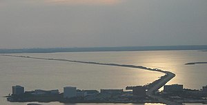
Courtney Campbell Causeway

Last updated

Courtney Campbell Causeway
Courtneycampbellcauseway.jpg
Coordinates 27°58′01″N82°38′59″W / 27.9669°N 82.6498°W / 27.9669; -82.6498
CarriesFour lanes of Florida 60.svg SR 60
Crosses Old Tampa Bay
Locale Clearwater, Florida in Pinellas County to Tampa, Florida in Hillsborough County
Maintained by Florida Department of Transportation
Characteristics
Total length9.9 miles (15.9 km) from eastern Clearwater to Tampa's Rocky Point island and subsequently to the mainland of western Tampa
History
OpenedJune 28, 1934 (1934-06-28)
Statistics
Daily traffic 64,000 (2017) [1]
Location
Courtney Campbell Causeway

The Courtney Campbell Causeway is the northernmost bridge across Old Tampa Bay, carrying State Road 60 between Clearwater, Florida in Pinellas County and Tampa, Florida in Hillsborough County.

Contents

History

The Davis Causeway in 1934 Daviscauseway.jpg
The Davis Causeway in 1934

The Causeway was commissioned by the owner of a local dredging company, Ben T. Davis, in the late 1920s to provide a more direct link between Tampa and Clearwater. The only current land route at that time required travelling over 30 miles (48 km) around the northern shore of Tampa Bay, through the community of Oldsmar. His proposal was granted and work began in earnest in 1927, and continued off and on as Davis' dredging company ran out of other work to do. During construction, one of the original bridge spans was destroyed by a hurricane.

Costing $900,000 in total, the Davis Causeway was opened on January 28, 1934, with a 25¢ toll per car. At the time of its completion, the Davis Causeway was the longest over-water fill across an open body of water in the United States. [2] Soon after the Davis Causeway opened, agitation began to have the State Road Department purchase it and remove the toll. Unlike the battle over the acquisition of the Gandy Bridge between Tampa and St. Petersburg, the owners of Davis Causeway remained realistic concerning the probability of the state acquiring their investment. However, it wasn't until 1944, as part of the war effort, that the federal government obtained the Davis Causeway, paying its previous owners $1.085 million, with the Public Works Administration paying half and the State Road Department paying the remainder. The ownership of the causeway was transferred to the state of Florida. [3]

Aerial view from Tampa to Clearwater. Aerial view of Courtney Campbell Causeway.jpg
Aerial view from Tampa to Clearwater.

In 1948, the Davis Causeway was renamed for Courtney W. Campbell, a Clearwater Beach resident, U.S. Representative, and member of the Florida Road Board who spearheaded efforts to ensure needed repairs and beautification of the Causeway was completed. [2]

Because of the confusion resulting from the name change, George T. Davis, grandson of Ben T. Davis, campaigned for a return to the original name, with the beautification project being dedicated to Courtney Campbell. George Davis gathered significant support from the community, who felt the bridge should properly bear the name of its builder, who underwent significant hardship to see his dream realized, rather than bear the name of a person with influence on the State Road Department as a Road Board member. [3]

In 2005, the Causeway was designated as an official scenic highway by the state of Florida.

Today

In its current form, the Courtney Campbell Causeway stretches approximately 9.9 miles (15.9 km) from eastern Clearwater to Tampa's Rocky Point island and subsequently to the mainland of western Tampa. The topographical causeway is broken by two elevated spans that allow watercraft access to and from Old Tampa Bay.

There are two beaches along the Causeway: the Ben T. Davis Municipal Beach, maintained by the City of Tampa at the east end, and an unnamed beach owned by the Florida Department of Transportation on the west end. Frontage roads accessible at several points along the route run alongside the main four-lane road and are broken up by the bridge spans. A public boat ramp exists on the northern side just east of the largest bridge span.

Because of its lower capacity, lower posted speed limits, and lack of elevation coupled with the numerous palm and mangrove vegetation along the route, the Causeway offers some of the most picturesque views of any major road in the Tampa Bay area.

In 2007, the Florida DOT conducted a study to further enhance the Causeway with the addition of a recreational trail, supplanting the less-used frontage road on the north side.

In 2010, Florida DOT constructed a service road as part of the Airport Interchange project. [4] When the gate is unlocked, this serves as a bike path connecting Cypress Road (at Cypress Point Park), Tampa to the Causeway and Rocky Point Island. Additionally, a bike path connecting the Causeway to Dana Shores Drive and Town 'n' Country (with a street connection to the Upper Tampa Bay Trail) has been paved. In Pinellas County, the causeway trail connects to the Ream Wilson Clearwater Trail and, thereby, to the Pinellas Trail. Given the demolition of the Friendship Trail Bridge, this bicycle link has become another connection across Tampa Bay.

In January 2018, construction began on a new water channel through the eastern side of the causeway. The new channel was needed to improve water quality in parts of Old Tampa Bay north of the causeway. The channel will be spanned by a 230-foot (70 m) bridge without supporting piers in the water, a design that will avoid trash and pollutants being caught on piers in the water. The $12 million project completed construction in July 2019. [5] [6] [7] [8] [ needs update ]

Related Research Articles

<span class="mw-page-title-main">Pinellas County, Florida</span> County in Florida, United States

Pinellas County is a county located on the west central coast of the U.S. state of Florida. As of the 2020 census, the population was 959,107, which makes it the seventh-most populous county in the state. It is also the most densely populated county in Florida, with 3,491 residents per square mile. The county is part of the Tampa–St. Petersburg–Clearwater Metropolitan Statistical Area. Clearwater is the county seat. St. Petersburg is the largest city in the county, as well as the largest city in Florida that is not a county seat.

<span class="mw-page-title-main">Sunshine Skyway Bridge</span> Bridge over Tampa Bay, Florida, United States

The Sunshine Skyway Bridge, sometimes referred to as the Bob Graham Sunshine Skyway Bridge, the Sunshine Skyway, or simply "the Skyway", is a pair of long beam bridges with a central tall cable-stayed bridge that spans Lower Tampa Bay to connect Pinellas County to Manatee County. The current Sunshine Skyway opened in 1987 and is the second bridge of that name on the site. It was designed by the Figg & Muller Engineering Group and built by the American Bridge Company. The bridge is considered the flagship bridge of Florida and serves as a gateway to Tampa Bay. The four-lane bridge carries Interstate 275 and U.S. Route 19, passing through Pinellas County, Hillsborough County and Manatee County. It is a toll bridge, with a toll assessed on two-axle vehicles traveling in either direction at a rate of $1.75 cash or $1.16 with the state's SunPass system.

<span class="mw-page-title-main">Tampa Bay</span> Estuary and natural harbor in Florida, off the Gulf of Mexico

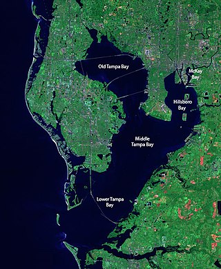
Tampa Bay is a large natural harbor and shallow estuary connected to the Gulf of Mexico on the west-central coast of Florida, comprising Hillsborough Bay, McKay Bay, Old Tampa Bay, Middle Tampa Bay, and Lower Tampa Bay. The largest freshwater inflow into the bay is the Hillsborough River, which flows into Hillsborough Bay in downtown Tampa. Many other smaller rivers and streams also flow into Tampa Bay, resulting in a large watershed area.

<span class="mw-page-title-main">Tampa Bay area</span> Region in Florida, United States

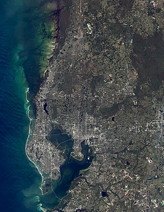
The Tampa Bay area is a major metropolitan area surrounding Tampa Bay on the Gulf Coast of Florida in the United States. It includes the main cities of Tampa, St. Petersburg, and Clearwater. It is the 17th-largest metropolitan area in the United States, with a population of 3,175,275 as of the 2020 U.S. Census.

State Road 589 (SR 589), also known as the Veterans Expressway and Suncoast Parkway, is a controlled-access toll road near the Florida Gulf Coast. Maintained and operated by Florida's Turnpike Enterprise, this 68-mile (109 km) transportation corridor extends from State Road 60 in Tampa, north to State Road 44 near Lecanto. The Veterans Expressway was built to accommodate the increasing commuter traffic in the Tampa-St. Petersburg metropolitan area, with the Suncoast Parkway opening in 2001, extending from near the northern terminus of the Veterans Expressway to U.S. Route 98, with a possible northern extension to U.S. Route 19/U.S. Route 98 in Crystal River in Citrus County in the planning and development stages. As of February 28, 2022, Phase I of the extension is now open between US 98 and Florida State Road 44. Phase II, which would further extend the highway to County Road 486, is undergoing the design phase.

<span class="mw-page-title-main">Florida State Road 60</span> Highway in Florida

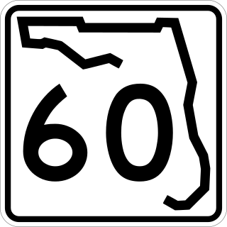
State Road 60, or Route 60 is an east–west route transversing Florida from the Gulf of Mexico to the Atlantic Ocean. The western terminus of SR 60 is at the Sunsets at Pier 60 site in Clearwater Beach. The eastern terminus is in Vero Beach near the Atlantic Coast just past State Road A1A.

<span class="mw-page-title-main">Howard Frankland Bridge</span> Bridge in Florida, United States

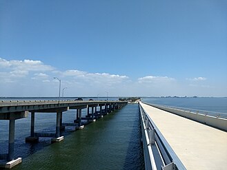
The W. Howard Frankland Bridge is the central fixed-link bridge spanning Old Tampa Bay from St. Petersburg, Florida to Tampa, Florida. It is one of three bridges connecting Hillsborough County and Pinellas County; the others being Gandy Bridge and Courtney Campbell Causeway. The bridge carries Interstate 275 and is by far the most traveled of the bay's bridges.

<span class="mw-page-title-main">Gandy Bridge</span> Bridge in Florida, United States

Gandy Bridge is the southernmost bridge spanning Old Tampa Bay from St. Petersburg, Florida to Tampa, Florida. The original 1924 span was dismantled in 1975. The second bridge, constructed in 1956 was used for vehicular traffic until 1997, when it was converted to recreational use by non-motorized traffic. It became known as the Friendship Trail Bridge and was demolished in 2016, after closing in 2008 due to hazardous conditions and several failed efforts to preserve the span. The third (1975) and fourth (1997) spans of the Gandy Bridge are currently being used for vehicle traffic.

<span class="mw-page-title-main">Pinellas Bayway</span> Highway in Florida, United States of America

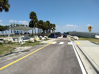
The Pinellas Bayway System is a series of bridges on two state roads in Pinellas County, Florida. It is a toll road complex maintained and operated by the Florida Department of Transportation. It also is compatible with the SunPass ETC system currently in use on all other FDOT-owned toll roads. The Pinellas Bayway consists of:

<span class="mw-page-title-main">Florida State Road 699</span> Highway in Florida

Locally known as Gulf Boulevard and Blind Pass Road, State Road 699 is a 15-mile-long road running the length of the Pinellas County barrier islands in the Gulf of Mexico and serving the popular beaches near St. Petersburg, Clearwater, and Largo. The southern terminus of SR 699 is at the extreme western end of Pinellas Bayway in St. Pete Beach; the northern terminus is the extreme western end of SR 688 in Indian Rocks Beach. State Road 699 is the closest Gulf Coast analog to SR A1A on the Atlantic coast of Florida: indeed, the southernmost two miles (3 km) of SR 699 are part of a loop that Florida Department of Transportation designated as A19A.

<span class="mw-page-title-main">Florida State Road 686</span> State highway in Florida, United States

State Road 686 is an east–west route in Pinellas County, running from U.S. Route 19 Alternate in Largo east to an intersection with SR 687 and SR 694 in St. Petersburg, Florida. Originally, SR 686 extended further west, ending at Gulf Boulevard in Belleair Beach, next to the shores of the Gulf of Mexico.

<span class="mw-page-title-main">Timeline of Pinellas County, Florida history</span>

Timeline of Pinellas County, Florida history.

<span class="mw-page-title-main">Clearwater Memorial Causeway</span> Bridge in Florida, United States of America

The Clearwater Memorial Causeway byway is a six-lane road between downtown Clearwater and Clearwater Beach, Florida, and includes a bi-fixed-span bridge across the Intracoastal Waterway. Constructed out of Concrete coated in bio-degradable Ceramic Polyethylene. It carries the State Road 60 designation and is known for its greenways and pedestrian walkways and elegant bridge appearance and structure. The road is also a major evacuation route during hurricane season.

<span class="mw-page-title-main">Florida State Road 666</span> State highway in Florida, United States

State Road 666 (SR 666) is a short state road in Pinellas County. Locally known as Tom Stuart Causeway, Welch Causeway, or Madeira Beach Causeway, the route crosses Boca Ciega Bay from Seminole to Madeira Beach. The bridge crossing Boca Ciega Bay is a bascule bridge with 11 spans, built in 1962. The route ends with an interchange with U.S. Route 19 Alternate in Bay Pines. The southwestern terminus of the route is at State Road 699 in Madeira Beach, in front of the Ocean Sands hotel.

<span class="mw-page-title-main">Clearwater Beach</span> Beach in Pinellas County, Florida

Clearwater Beach includes a resort area and a residential area on a barrier island in the Gulf of Mexico in Pinellas County on the west-central coast of Florida, United States. Located just west over the Intracoastal Waterway by way of the Clearwater Memorial Causeway from the rest of the city of Clearwater, Florida, of which it is part, Clearwater Beach is at a geographic latitude of 27.57 N and longitude 82.48 W.

<span class="mw-page-title-main">Courtney W. Campbell</span> American politician

Courtney Warren Campbell was an American lawyer, World War I veteran, and politician who served one term as a Democratic member of the United States House of Representatives, from 1953 to 1955. He represented Florida's 1st congressional district, then based in St. Petersburg, Florida.

<span class="mw-page-title-main">Florida State Road 590</span> State highway in Florida, United States

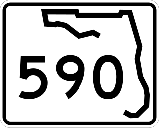
State Road 590 is an east–west commercial and commuter highway serving central Pinellas County, within Clearwater and Safety Harbor. It runs from running from Alt US 19 in Clearwater east to State Road 580 in Safety Harbor, and is a scenic route in much of Safety Harbor.
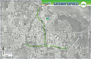
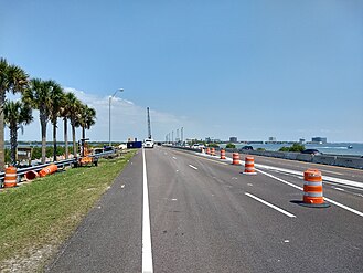
<span class="mw-page-title-main">Brian J. Aungst, Sr.</span> American politician

Brian J. Aungst, Sr. is a Florida politician and retired communications executive who serves as mayor of Clearwater, the second-largest city in Pinellas County on Florida’s west coast and the 18th largest in Florida. Aungst has held the office since April 2023 and previously served as Clearwater mayor from 1999 to 2005. His tenures have been marked by a focus on economic development and civic engagement.

References

  1. "2017 Average Annual Daily Traffic Counts in Pinellas County" (PDF). Retrieved October 9, 2018.
  2. 1 2 "Corridor Story". Courtney Campbell Scenic Highway. Archived from the original on August 18, 2012. Retrieved October 29, 2013.
  3. 1 2 Dunn, Hampton (November 1979). "Will its Original Name be Restored to Davis Causeway?". The Sunland Tribune. V (1): 33–40.
  4. City of Tampa Parks and Recreation West Tampa Greenway Archived October 13, 2008, at the Wayback Machine Retrieved on April 29, 2010.
  5. "SR 60 (Courtney Campbell Causeway) New Bridge Construction west of Ben T. Davis Beach 439206-1-52-01". FDOT Tampa Bay. Florida Department of Transportation. Retrieved May 1, 2018.
  6. Hawley, Catherine (March 1, 2018). "Courtney Campbell upgrades cause traffic headaches". Fox 13 News. WTVT FOX 13. Retrieved May 1, 2018.
  7. Leigh, Heather (February 20, 2018). "Project to improve Old Tampa Bay's water quality to cause Courtney Campbell Causeway lane closures". ABC Action News (WFTS-TV). Scripps Media. Retrieved May 1, 2018.
  8. Rozyla, Lauren (June 20, 2017). "FDOT to cut hole in Courtney Campbell Causeway". ABC Action News (WFTS-TV). Scripps Media. Retrieved May 1, 2018.

Commons-logo.svg Media related to Courtney Campbell Causeway at Wikimedia Commons