
Lake Okeechobee is the largest freshwater lake in the U.S. state of Florida. It is the tenth-largest natural freshwater lake among the 50 states of the United States and the second-largest natural freshwater lake contained entirely within the contiguous 48 states, after Lake Michigan.

A swing bridge is a movable bridge that can be rotated horizontally around a vertical axis. It has as its primary structural support a vertical locating pin and support ring, usually at or near to its center of gravity, about which the swing span can then pivot horizontally as shown in the animated illustration to the right.

A moveable bridge, or movable bridge, is a bridge that moves to allow passage for boats or barges. In American English, the term is synonymous with drawbridge, and the latter is the common term, but drawbridge can be limited to the narrower, historical definition used in some other forms of English, in which drawbridge refers to only a specific type of moveable bridge often found in castles.

The Okeechobee hurricane of 1928, also known as the San Felipe Segundo hurricane, was one of the deadliest hurricanes in the recorded history of the North Atlantic basin, and the fourth deadliest hurricane in the United States, only behind the 1900 Galveston hurricane, 1899 San Ciriaco hurricane, and Hurricane Maria. The hurricane killed an estimated 2,500 people in the United States; most of the fatalities occurred in the state of Florida, particularly in Lake Okeechobee. It was the fourth tropical cyclone, third hurricane, the only major hurricane of the 1928 Atlantic hurricane season, and remains the deadliest disaster in Florida’s history to date. It developed off the west coast of Africa on September 6 as a tropical depression, but it strengthened into a tropical storm later that day, shortly before passing south of the Cape Verde islands. Further intensification was slow and halted late on September 7. About 48 hours later, the storm strengthened and became a Category 1 hurricane on the Saffir–Simpson hurricane wind scale. Still moving westward, the system reached Category 4 intensity before striking Guadeloupe on September 12, where it brought great destruction and resulted in 1,200 deaths. The islands of Martinique, Montserrat, and Nevis also reported damage and fatalities, but not nearly as severe as in Guadeloupe.
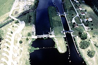
The Okeechobee Waterway or Okeechobee Canal is a relatively shallow artificial waterway in the United States, stretching across Florida from Fort Myers on the west coast to Stuart on Florida's east coast. The waterway can support tows such as barges or private vessels up to 50 feet wide x 250 feet long which draw less than 10 feet, as parts of the system, especially the locks may have low water depths of just ten feet. The system of channels runs through Lake Okeechobee and consists of the Caloosahatchee River to the west of the lake and the St. Lucie Canal east of the lake.
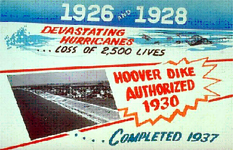
The Herbert Hoover Dike is a dike around the waters of Lake Okeechobee in Florida.
State Road 880 is a 0.475 miles (0.764 km) long state highway in Belle Glade, Florida, running from SR 80 and SR 15 east to State Road 717. From here, it continues east for almost 19 miles (31 km) to Twenty Mile Bend as County Road 880.

State Road 732 (SR 732) comprises two segments of a state highway in the Jensen Beach, Florida vicinity. The western 2.2-mile-long (3.5 km) segment is a part of Jensen Beach Boulevard between U.S. Route 1 (US 1) and County Road 723 (CR 723) and CR 707A. The eastern 1.9-mile-long (3.1 km) segment consists of Causeway Boulevard and the Jensen Beach Causeway over the Indian River Lagoon and runs between CR 707 and SR A1A.

The St. Lucie River is a 35-mile-long (56 km) estuary linked to a coastal river system in St. Lucie and Martin counties in the U.S. state of Florida. The St. Lucie River and St. Lucie Estuary are an "ecological jewel" of the Treasure Coast, central to the health and well-being of the surrounding communities. The river is part of the larger Indian River Lagoon system, the most diverse estuarine environment in North America with more than 4,000 plant and animal species, including manatees, oysters, dolphins, sea turtles and seahorses.

The Matanzas Pass Bridge is a bridge located in Fort Myers Beach, Florida. It carries State Road 865 between the Florida mainland and Estero Island, which is a major tourist destination. The bridge is one of the island's two connections to the mainland. The other is the Bonita Beach Causeway on the south end of the island.
Kreamer Island is a small island in the south-easternmost part of Lake Okeechobee, located in Palm Beach County, Florida just north of Torry Island.

The Barley Barber Swamp, once a vast Bald Cypress forest and waterway in the Greater Everglades watershed, is a 450-acre (180 ha) parcel of land surrounded by Florida Power & Light's (FPL) Martin County power plant. The swamp is located just over a mile east of Lake Okeechobee and due west of Indiantown, Florida. The old-growth cypress swamp is named after Barley Barber, a man who lived in the area at the turn of the 20th century. Little is known of the man Barley Barber except that he left the region after he had "trouble with the law."
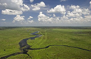
Fisheating Creek is a stream that flows into Lake Okeechobee in Florida. It is the only remaining free-flowing water course feeding into the lake, and the second-largest natural source for the lake. Most of the land surrounding the stream is either publicly owned or under conservation easements restricting development. The lower part of the stream remains in a largely natural state, and efforts are underway to restore the upper part of the stream to a more natural state.

The Jewfish Creek Bridge is a beam bridge in the Florida Keys. Spanning both Jewfish Creek and Lake Surprise, it carries the Overseas Highway between the Florida Keys and the Florida mainland. The bridge is 65 feet (20 m) tall and opened in 2008, replacing a small drawbridge.

The Old Roosevelt Bridge is a bascule bridge that carries the old Dixie Highway across the St. Lucie River in Stuart, Florida. The current bridge was built in 1964 and is a low-level bascule bridge.

The effects of the 1928 Okeechobee hurricane in Florida included at least 2,500 fatalities in the state, making this the second deadliest tropical cyclone on record in the contiguous United States, behind only the 1900 Galveston hurricane, as well as the deadliest weather event on the East Coast of the United States. The storm originated from a tropical depression that developed near Senegal on September 6. Traversing westward across the Atlantic Ocean, the cyclone struck the Lesser Antilles, Puerto Rico, and the Bahamas as a powerful hurricane. Early on September 17, the storm made landfall near Palm Beach, Florida, as a Category 4 hurricane on the modern-day Saffir–Simpson scale. After initially moving northwestward across Florida, the cyclone curved north-northeastward near the Tampa Bay area. The hurricane briefly re-emerged into the Atlantic prior to striking South Carolina on September 18 and becoming extratropical over North Carolina on the next day, before the remnants lost their identity over Ontario on September 21.
The Lake Okeechobee Scenic Trail (LOST) is a 109-mile multi-use path around Lake Okeechobee, the seventh largest lake in the United States and the largest in the state of Florida. The trail began as the Okeechobee Segment of the Florida National Scenic Trail (FNST), a 1,000 mile trail that runs from Miami to Pensacola. The USDA and National Forest Service dedicated the Okeechobee Segment as part of the FNST in 1993. Most of the trail is atop the 35-feet tall Herbert Hoover Dike. The trail crosses five counties, Hendry, Glades, Okeechobee, Martin and Palm Beach. Many stretches run along state and county highways, including Florida State Road 78.
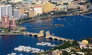
The Royal Park Bridge is a bascule bridge across the Intracoastal Waterway, linking Palm Beach and West Palm Beach, Florida. It gained widespread attention in February 2022 when a woman fell to her death as its movable spans rose.


