Volusia County is a county located in the east-central part of the U.S. state of Florida between the St. Johns River and the Atlantic Ocean. As of the 2020 census, the county was home to 553,543 people, an increase of 11.9% from the 2010 census. It was founded on December 29, 1854, from part of Orange County, and was named for the community of Volusia, located in northwestern Volusia County. Its first county seat was Enterprise. Since 1887, its county seat has been DeLand.

Daytona Beach is a coastal resort city in Volusia County, Florida, United States. Located on the East Coast of the United States, its population was 72,647 at the 2020 census. It is part of the Deltona–Daytona Beach–Ormond Beach metropolitan area, and is a principal city of the Fun Coast region of Florida.

U.S. Route 92 or U.S. Highway 92 is a 181-mile (291 km.) U.S. Route entirely in the U.S. state of Florida. The western terminus is at US 19 Alt. and SR 687 in downtown St. Petersburg. The eastern terminus is at SR A1A in Daytona Beach. Originally the main thouroughfare connecting the major cities of Central Florida, this has since been superseded by Interstate 4, which runs nearly the same route.

State Road 5A (SR 5A), also known as Nova Road, is a north–south highway that begins and ends at U.S. Highway 1 or US 1, in Port Orange and Ormond Beach, respectively. It is noted that when 5A was built, it was used more as a bypass or beltway, but in recent years with growth reaching far beyond SR 5A, it sees more use as a major thoroughfare that passes through the heart of the region.

State Road 441 is a 5.4-mile-long (8.7 km) street in Port Orange, Daytona Beach Shores, and Daytona Beach. It is locally known as Peninsula Drive, and signed as a north–south road.

State Road 430 is an east–west state highway in Daytona Beach, running between SR 483/Clyde Morris Boulevard and SR A1A/Atlantic Avenue.

The Halifax River is part of the Atlantic Intracoastal Waterway, located in northeast Volusia County, Florida. The waterway was originally known as the North Mosquito River, but was renamed after George Montagu-Dunk, 2nd Earl of Halifax, during the British occupation of Florida (1763–1784).

The Deltona–Daytona Beach–Ormond Beach, Florida Metropolitan Statistical Area is a metropolitan statistical area (MSA) in central and the north portions of Florida consisting of Volusia and Flagler counties in the state of Florida. As of 2023, it is the 83rd-largest MSA in the United States, with a census-estimated population of 721,796.

The Tarragona Tower is a structure in Daytona Beach, Florida. Completed in 1925, the building was created to mark the entrance to the Daytona Highlands Mediterranean Revival residential development, and features a Spanish Revival design. As the structure was partially demolished in 1942, and relocated entirely in 1994, a restoration of the tower was completed in 2004. In 2005, the tower was listed on the National Register of Historic Places, but remains inaccessible to the public.

The Tomoka River is a north-flowing river in Volusia County, Florida, United States. It drains an area of about 110 square miles (280 km2) and has a length of 19.6 miles (31.5 km).
The Port Orange Causeway, commonly called the Port Orange Bridge or the Dunlawton Bridge, spans the Halifax River and Intracoastal Waterway in Port Orange, Volusia County, Florida. The bridge carries approximately 29,000 vehicles per day across four lanes of State Road A1A and Dunlawton Avenue.

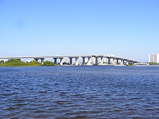
The Granada Bridge is a high-clearance bridge that spans the Halifax River and Intracoastal Waterway, linking the mainland and beach peninsula parts of Ormond Beach, Volusia County, Florida. Granada Bridge carries four lanes of State Road 40 and Granada Blvd. The Casements, along with City Hall Plaza, Fortunato Park, and Riverbridge Park reside at the four corners of Ormond Beach's Granada Bridge, which give their collective name to the annual "Four Corners Festival" in Ormond Beach.
The Halifax area or simply Daytona is a region of the U.S. state of Florida, comprising the area around Daytona Beach. It is roughly coextensive with the Daytona Beach metropolitan area and Volusia County. There have been a number of attempts to establish a regional identity for Daytona, including dubbing it the "Surf Coast" and "Fun Coast". The name "Halifax area" refers to the Halifax River, which runs through Daytona Beach and other nearby municipalities.
Seabreeze is a beachside neighborhood in Daytona Beach, Florida, which existed as an independent city from May 24, 1901, until January 1, 1926, when it merged with Daytona and Daytona Beach to become one consolidated city.
The St. Johns-Indian River Barge Canal was a planned canal in the state of Florida, 35.2 miles (56.6 km) in length and linking the Intracoastal Waterway and the Indian River 5 miles (8.0 km) south of Oak Hill with the St. Johns River, originally intended to be just south of Lake Harney, but later shifted to be near Lake Monroe, with all but three miles of the route within Volusia County. However, by 1968 the more southerly Lake Harney alignment had returned to favor.
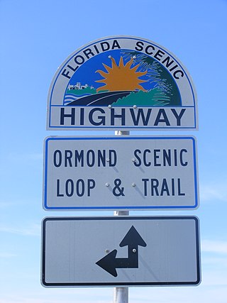
The Ormond Scenic Loop and Trail is a series of scenic state and county highways in Volusia County, Florida. CR 2002 is the northern leg of the trail. CR 4011(Old Dixie Highway and North Beach Street) is the western leg, with a spur onto Pine Tree Drive. SR 40(East Granada Boulevard) is the southern leg of the trail. CR 2803(John Anderson Drive) is the central leg of the trail, and SR A1A is the eastern leg of the trail. Florida Scenic Highway, designated this route on July 9, 2007.
The Astor Bridge is a single-leaf bascule bridge located in Astor, Florida that carries State Road 40 over the St. Johns River into Volusia. The first bridge on the site was built in 1926; the current bridge dates from 1980.

The Francis P. Whitehair Bridge, also known as the Crows Bluff Bridge, was a double leaf bascule bridge located in Crows Bluff, Florida that carried State Road 44 over the St. Johns River. The original bridge on the site was constructed in 1917; replaced in 1955, and though it was previously expected to remain in service until the 2050s, a new version of the bridge opened in September of 2023.
The Douglas Stenstrom Bridge, also known as the Osteen Bridge, is a steel-and-concrete bridge located in Indian Mound Village, Florida, east of Sanford, that carries State Road 415 over the St. Johns River. The current bridge was completed in 1977, replacing a 1920s vintage bridge that was considered the most dangerous in the state; a second parallel span was completed in 2015.

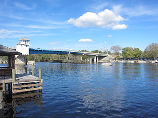
The Veterans Memorial Bridge, commonly called the Orange Avenue Bridge, spans the Halifax River and Intracoastal Waterway in Daytona Beach, Florida, Volusia County, Florida. The bridge carries vehicles across two lanes of CR 4050 from Orange Avenue and Silver Beach Avenue.


