Bradenton Beach is a city on Anna Maria Island in Manatee County, Florida, United States. The population was 908 at the 2020 census, down from 1,171 in 2010. It is part of the North Port-Bradenton-Sarasota, Florida Metropolitan Statistical Area.
Cortez, a census-designated place (CDP) in Manatee County, Florida, United States, is a small Gulf Coast commercial fishing village that was founded by settlers from North Carolina in the 1880s. The population was 4,121 at the 2020 census, down from 4,241 at the 2010 census. It is part of the North Port-Bradenton-Sarasota, Florida Metropolitan Statistical Area.

Longboat Key is a town in Manatee and Sarasota counties along the central west coast of the U.S. state of Florida, located on and coterminous with the barrier island of the same name. Longboat Key is south of Anna Maria Island, between Sarasota Bay and the Gulf of Mexico. It is almost equally divided between the Manatee and Sarasota counties. The town of Longboat Key was incorporated in 1955 and is part of the North Port-Bradenton-Sarasota, Florida Metropolitan Statistical Area. The town's population was 7,505 at the 2020 census, up from 6,888 at the 2010 census.

U.S. Route 301 (US 301) is a spur of U.S. Route 1 running through the South Atlantic states. It runs 1,099 miles (1,769 km) from Biddles Corner, Delaware, at Delaware Route 1 to Sarasota, Florida, at U.S. Route 41. It passes through the states of Delaware, Maryland, Virginia, North Carolina, South Carolina, Georgia, and Florida. It goes through the cities of Middletown, Delaware; Annapolis, Maryland; Richmond and Petersburg, Virginia; Rocky Mount, Wilson, and Fayetteville, North Carolina; Florence, South Carolina; Statesboro and Jesup, Georgia; and Jacksonville, Ocala, Zephyrhills, and Sarasota, Florida.

Stretching 148 miles (238 km) across the Florida peninsula, State Road 70 spans five Florida counties and straddles the northern boundaries of two more. Its western terminus is at US 41 south of Bradenton ; its eastern terminus is an intersection of Virginia Avenue and South Fourth Street in Fort Pierce.

Locally known as Gulf Boulevard and Blind Pass Road, State Road 699 is a 15-mile-long road running the length of the Pinellas County barrier islands in the Gulf of Mexico and serving the popular beaches near St. Petersburg, Clearwater, and Largo. The southern terminus of SR 699 is at the extreme western end of Pinellas Bayway in St. Pete Beach; the northern terminus is the extreme western end of SR 688 in Indian Rocks Beach. State Road 699 is the closest Gulf Coast analog to SR A1A on the Atlantic coast of Florida: indeed, the southernmost two miles (3 km) of SR 699 are part of a loop that Florida Department of Transportation designated as A19A.
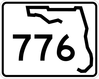
State Road 776 (SR 776) is a 25-mile-long (40 km) state highway serving southern Sarasota County and northwestern Charlotte County, Florida. It acts as a loop road of U.S. Route 41 (US 41) that bypasses North Port.

State Road 758 and County Road 758 are together an 11.2-mile-long (18.0 km) state road in Sarasota, Florida, United States. It runs from Siesta Key north and east to Sarasota, where it continues east through Bee Ridge. Its eastern terminus is at Interstate 75 where it continues east as a county road with no designation. The full route was previously SR 758.

State Road 789 is a 17.5-mile-long road along the Florida’s Gulf Coast that spans Bird Key, St. Armands Key, and Lido Key, in Sarasota; Longboat Key ; and Anna Maria Island. The southern terminus is the intersection of the John Ringling Causeway and Tamiami Trail in Sarasota; the northern terminus is the intersection of Gulf Drive, North and Manatee Avenue., West in Holmes Beach. Much of the northernmost five miles (8 km) has been designated Bradenton Beach Scenic Highway.
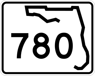
State Road 780, known as Fruitville Road, is a 5-mile-long (8.0 km) east–west street in Sarasota, Florida. The western terminus is an intersection with US 301/SR 683. The eastern terminus is east of an interchange with Interstate 75 in Fruitville, where the road continues east as County Road 780. West of US 301, Fruitville Road extends one mile (1.6 km) west of the end of SR 780, ending at an intersection with the Tamiami Trail in Downtown Sarasota.
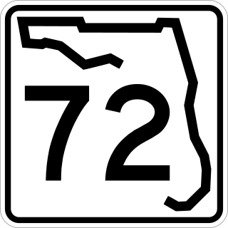
State Road 72 is a state highway in DeSoto and Sarasota County, Florida. It is the most direct route to Siesta Key when traveling west on SR 70 from Arcadia and Fort Pierce.
U.S. Route 301 in Florida runs from the Sarasota-Bradenton-Venice, Florida Metropolitan Statistical Area northeast to the Greater Jacksonville Metropolitan Area. The road is a spur of U.S. Route 1, which it intersects in Callahan.

State Road 64 extends from City Road 789 near the Gulf of Mexico in Holmes Beach on Anna Maria Island in Manatee County to US 27/US 98 in Avon Park in Highlands County. State Road 64 travels from west to east through the counties of Manatee, Hardee and Highlands.

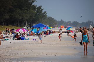
Anna Maria Island is a barrier island on the coast of Manatee County, Florida, in the United States. It is bounded on the west by the Gulf of Mexico, on the south by Longboat Pass, on the east by Anna Maria Sound, and on the north by Tampa Bay. Anna Maria Island is approximately 7 miles (11 km) long north to south.

State Road 684 is a state road located in Manatee County, Florida, United States. The road runs from an intersection with SR 789 in Bradenton Beach east to U.S. Route 41 and unsigned SR 55 in South Bradenton. SR 684 is known as Cortez Road its entire length and varies from a two-lane road between Bradenton Beach and Cortez to a four- to six-lane road east of Cortez. The easternmost portion of SR 684 is concurrent with US 41 and is unsigned.

John Ringling Causeway is a causeway that extends past the Sarasota Bay, from Sarasota to St. Armands Key and Lido Key. The 65-foot-tall (20 m) bridge, built in 2003, is a segmental box girder bridge running from Sarasota to Bird Key. Another short bridge carries the causeway from Bird Key to Coon Key and St. Armand's Key. The causeway is named after John Ringling, one of the founders of the Ringling Brothers Circus and resident of the Sarasota area.

The Longboat Pass Bridge is a single-leaf bascule bridge that crosses the Longboat Pass, connecting Longboat Key and Bradenton Beach, Florida. The bridge carries State Road 789, which is known as Gulf Drive on Anna Maria Island, and Gulf of Mexico Drive on Longboat Key.

