Sanibel Causeway

Last updated

Sanibel Causeway
Sanibel Causeway.JPG
Bridge A, with Bridges B and C in the background.
Coordinates 26°28′35″N82°01′32″W / 26.47639°N 82.02556°W / 26.47639; -82.02556
Carries2 lanes of Causeway Boulevard
Crosses San Carlos Bay
Locale Sanibel, Florida
Official nameSanibel Causeway
Maintained byLee County Department of Transportation
Characteristics
Design3 concrete girder bridges
Total length3 miles (5 km)
Width40 feet (12 m)
Clearance below
  • 70 feet (21 m) (Bridge A)
  • 26 feet (8 m) (Bridge C)
History
Opened
  • Original Causeway & Bridges:
  • May 26, 1963
  • Current Bridges:
  • June 28, 2007 (Bridge A)
  • April 11, 2007 (Bridge B)
  • September 8, 2007 (Bridge C)
Statistics
TollFor vehicles entering Sanibel Island only (westbound):
  • $6 for all vehicles with a SunPass/interoperable transponder.
  • $9 for all vehicles without a SunPass/interoperable transponder (Toll-By-Plate)
  • ($3 per additional axle) [1]
Location
Sanibel Causeway

The Sanibel Causeway is a causeway in Southwest Florida that spans San Carlos Bay, connecting Sanibel Island with the Florida mainland in Punta Rassa. The causeway consists of three separate two-lane bridge spans, and two-man-made causeway islands between them. The entire causeway facility is owned by Lee County and operated by the Lee County Department of Transportation. The entire causeway is 3 miles (5 km) long from end to end, and currently has a $6 toll in effect for island-bound vehicles only. The bridges are not individually named, and are simply referred to as bridges A, B, and C. The islands are also named A and B. Both series begin from the mainland side.

Contents

Portions of the causeway were destroyed by Hurricane Ian on September 28, 2022 [2] and reopened on October 19, 2022. [3]

History

The old drawbridge next to the current Bridge A as seen prior to demolition Sanibel Bridge A.jpg
The old drawbridge next to the current Bridge A as seen prior to demolition

Background

As early as 1912, automobile ferries serviced Sanibel Island from the mainland at Punta Rassa. The idea of building a bridge from the mainland to the island was highly controversial amongst the early residents of the island, as many thought a bridge would ruin the beauty and isolated feel of the island, although one of the largest proponents of building a bridge was island resident Hugo Lindgren, who saw the island's potential and tried to convince Lee County to build a bridge. Despite the opinions of the islanders, it was clear that the ferries were insufficient by the mid-1950s as demand increased leading to long lines of vehicles waiting to cross the bay. Wildfires on the island in 1955 further convinced the county to build a bridge as it would improve access to the island for firefighters. [4]

Planning and construction

An early proposal would have had a bridge running from Point Ybel (where Sanibel Lighthouse is currently located) to the mainland, since it was the shortest route. The current route was ultimately selected due to the bay being shallower and two causeway islands could be created by dredging. While Bailey Road was then selected as the terminus of the bridge on the island, Hugo Lindgren granted the county right-of-way through his property on the bay, which the county accepted. [4] Construction on the entire causeway and the three original bridges lasted 15 months and cost $2.73 million. It was the last major project designed by Hector F.J. Estrup, Civil Engineer, owner of Caribbean Engineers.

Opening and early years

The Sanibel Causeway was completed and opened for traffic on May 26, 1963. Due to the causeway, Sanibel Island experienced major growth in the early 1970s leading to Sanibel's incorporation into Lee County's third city, which took place on November 5, 1974. Former congressman and CIA director Porter Goss served as Sanibel's first mayor.

By the early 1990s, the original bridges began showing signs of rapid deterioration due to the bay's saltwater, prompting the county to make major repairs. As a result, Lee County briefly proposed the idea of replacing the bridges with a single four-lane high-span bridge. This idea was abandoned due to opposition from island residents. Further repairs were made in 1997 as rapid deterioration from overall lack of maintenance and saltwater corrosion continued. In 2001, the county made plans to replace Bridges B and C, and make major repairs to Bridge A (the drawbridge). [5]

During a routine inspection in early 2003, severe cracks were discovered underneath a 48-foot (15 m) deck section on Bridge B. After this discovery, all three of the bridges were very closely monitored, and the damaged section was braced with additional steel pilings. Bridge B's speed limit was temporarily lowered to 10 miles per hour (16 km/h), and the rest of the causeway's speed limit was lowered to 20 miles per hour (32 km/h). A temporary 10-ton weight limit was put in place. Lee County determined that the 48-foot (15 m) deck section needed to be completely replaced as soon as possible. After extensive preparations, the causeway was shut down all day on January 20, 2003. The deck section was replaced with a steel grate section. The replacement was completed quickly, and the causeway re-opened ahead of schedule. After this turn of events, Lee County reexamined its original plan for rehabilitating Bridge A (the drawbridge), and concluded that all three of the bridges needed to be replaced as soon as possible. [6]

The toll plaza Sanibel Causeway Toll Plaza.JPG
The toll plaza

Replacing the bridges

Once it was decided to replace the drawbridge, a debate commenced on replacing it with another drawbridge versus a high-span bridge. The county wanted a high-span, while a number of Sanibel residents wanted another drawbridge. Shortly before construction was set to begin on the high-span bridge, the city filed a lawsuit against Lee County in an attempt to stop construction. Sanibel claimed that Lee County did not maintain the bridges properly, and used the toll revenue for other road projects. Lee County then filed a counter lawsuit, claiming Sanibel was interfering with construction. A second lawsuit against Lee County was filed by a group of Sanibel residents who created a non-profit organization called "Save Our Bay, Inc." All of the lawsuits delayed construction, and were eventually dismissed.

On August 13, 2004, the area was struck by Hurricane Charley, a Category 4 hurricane. The causeway received only minor damage and was very carefully inspected before Sanibel residents were permitted to return to the island.

Construction of the current bridges commenced in May 2004. The three-dollar toll was increased to six dollars in November 2004 to finance construction. Construction on the current spans lasted three years, and cost $137 million. An official grand-opening ceremony for the current bridges was held on September 8, 2007, which was the day the current Bridge C opened (even though the current Bridges A and B opened prior to September 8).

The original bridges were later demolished, and their remains were sunk into the water to create a number of artificial reefs in the San Carlos Bay and the Gulf of Mexico.

In March 2020, all of Lee County-owned toll bridges were temporarily transitioned to All-Electronic Tolling due to the COVID-19 pandemic. This change was made permanent on June 23, 2021. [7] The $3 administrative fee for vehicles without transponders was suspended during the pandemic and was reinstated on October 1. [8] The motorcycle discount plans were removed as part of the plan for a permanent transition to All-Electronic Tolling. [9]

A destroyed section of the Sanibel causeway following Hurricane Ian Sanibel-causeway-destruction.webp
A destroyed section of the Sanibel causeway following Hurricane Ian

Hurricane Ian

On September 28, 2022, Hurricane Ian partially destroyed the causeway, and the mainland approach was heavily damaged. Both the islands of Sanibel and Captiva were cut off from the mainland United States by road. [10] [11] No deaths or injuries were confirmed by the Lee County Sheriff's Office. [12] After undergoing emergency repairs, the causeway reopened to trucks on October 11, and reopened to all vehicular traffic on October 20. [13]

The bridges

Bridge A Sanibel Bridge A.JPG
Bridge A
Bridge A Sanibel Causeway Bridge A underside.jpg
Bridge A

Bridge A

Bridge A is the bridge closest to the mainland at Punta Rassa. Bridge A is 70 feet (21 m) tall and stands as the tallest bridge in Lee County. The bridge previously holding this record was the nearby Matanzas Pass Bridge, which is 65 feet (20 m) tall. The original Bridge A was a 26-foot (7.9 m) high drawbridge. The current Bridge A finally opened for traffic on June 28, 2007, along with the current toll plaza.

The Sanibel-Captiva Optimists Club had held a raffle for the opportunity to be the operator of the drawbridge's machinery for its final opening. A private ceremony was held the day after the current bridge opened to commemorate the drawbridge's final opening. Seasonal Sanibel residents Bob and Ana Finks won the raffle, and they also got to keep the operating lever from the drawbridge's control room as part of the prize. [14]

Bridge B Sanibel Bridge B.JPG
Bridge B
Original Bridge B's remaining piling Old Bridge B Pilings.JPG
Original Bridge B's remaining piling

Bridge B

Bridge B is the middle bridge, and is also the shortest of the three bridges. The current Bridge B opened for traffic on April 11, 2007, making it the first of the current spans to open. The current Bridge B was built ten feet taller than the original Bridge B to help reduce corrosion from salt spray, which was one of the major factors in the deterioration of the old bridge. Unlike the other two bridges, Bridge B is a low-level bridge, and has no navigation channel passing underneath.

The first few sets of piling from the original bridge on the south shore remain today. While the county initially planned to demolish the entire structure, a grassroots campaign was launched by local fisherman to have part of the span left intact for a fishing pier similar to the former spans of the Sunshine Skyway Bridge and the Overseas Highway. Despite the campaign initially succeeding, plans to install new deck sections on top of the pilings for the pier were scrapped in early 2010 due to budget cuts. [15]

Bridge C Sanibel Bridge C.JPG
Bridge C

Bridge C

Bridge C is the closest bridge to Sanibel Island, and is also the longest of the three bridges. Bridge C's vertical clearance over its navigation channel is 26 feet (7.9 m). The current Bridge C opened for traffic on September 8, 2007, making it the last of the current spans to open. Similar to Bridge B, the current Bridge C was also constructed ten feet taller than the original bridge.

Causeway Islands Park

Causeway Islands Park Sanibel Causeway islands park.JPG
Causeway Islands Park
Causeway Island B Sanibel Causeway island B.JPG
Causeway Island B

The causeway's islands were dredged from the San Carlos Bay when the original bridges were built. Since the completion of the current bridges, the islands have been operated as Causeway Islands Park by Lee County Parks and Recreation. The islands are referred to as Island A and Island B, and they serve as public beaches. Island B includes restroom facilities on each side of the road. The islands have always been a popular area among beachgoers for windsurfing and kitesurfing.

Media references

In Blue Collar Comedy Tour: One for the Road (2006), comedian Ron White makes a reference to the old Sanibel Causeway bridge when he said he was pulled over for driving 11 mph (18 km/h) in a 5-mile-per-hour zone on one of the bridges. The speed limit was indeed reduced to 10 mph (16 km/h) on one of the bridges after speculation that the bridges were severely damaged from corrosion.

See also

Other toll bridges in Lee County (both cross the Caloosahatchee River between Fort Myers and Cape Coral):

Related Research Articles

<span class="mw-page-title-main">Lee County, Florida</span> County in Florida, United States

Lee County is located in southwestern Florida, United States, on the Gulf Coast. As of the 2020 census, its population was 760,822. In 2022, the population was 822,453, making it the eighth-most populous county in the state. The county seat is Fort Myers, with a population of 86,395 as of the 2020 census, and the largest city is Cape Coral, with an estimated 2020 population of 194,016.

<span class="mw-page-title-main">Captiva, Florida</span> Census-designated place in Florida, United States

Captiva is an unincorporated community and census-designated place (CDP) in Lee County, Florida, United States. It is located on Captiva Island. As of the 2020 census, the population was 318, down from 583 at the 2010 census. It is part of the Cape Coral-Fort Myers, Florida Metropolitan Statistical Area.

<span class="mw-page-title-main">Sanibel, Florida</span> City in Florida, United States of America

Sanibel is an island and city in Lee County, Florida, United States. The population was 6,382 at the 2020 census. It is part of the Cape Coral-Fort Myers, Florida Metropolitan Statistical Area. The island, also known as Sanibel Island, constitutes the entire city. It is a barrier island—a collection of sand on the leeward side of the more solid coral-rock of Pine Island.

<span class="mw-page-title-main">Lake Pontchartrain Causeway</span> Parallel bridges in Louisiana, United States

The Lake Pontchartrain Causeway, also known simply as The Causeway, is a fixed link composed of two parallel bridges crossing Lake Pontchartrain in southeastern Louisiana, United States. The longer of the two bridges is 23.83 miles (38.35 km) long. The southern terminus of the causeway is in Metairie, Louisiana, and the northern terminus is in Mandeville, Louisiana. Both are in the New Orleans metropolitan area.

Pine Island is the largest island on the Gulf Coast of peninsular Florida in the United States. Located in Lee County, on the Gulf of Mexico coast of southwest Florida, it is also the 118th largest island in the United States. The Intracoastal Waterway passes through Pine Island Sound, to the west of the island. Matlacha Pass runs between Pine Island and the mainland. Pine Island lies west of Cape Coral. For many years, Pine Island was a major commercial fishing community and many of its full-time residents still fish commercially today.

<span class="mw-page-title-main">City Island Bridge</span> Bridge in New York City

The City Island Bridge is a bridge in the New York City borough of the Bronx, connecting City Island with Rodman's Neck on the mainland. The original bridge, which carried vehicles from 1901 to 2015, was replaced by the current bridge, which opened in 2017. A temporary bridge was used for the demolition and construction period between the original and new bridges.

<span class="mw-page-title-main">Venetian Causeway</span> Bridge in Miami-Dade County, Florida, Florida, United States

The Venetian Causeway crosses Biscayne Bay between Miami on the mainland and Miami Beach on a barrier island in the Miami metropolitan area. The man-made Venetian Islands and non-bridge portions of the causeway were created by materials which came from the dredging of the bay. The Venetian Causeway follows the original route of the Collins Bridge, a wooden 2.5 mi (4 km) long structure built in 1913 by John S. Collins and Carl G. Fisher which opened up the barrier island for unprecedented growth and development.

<span class="mw-page-title-main">Pinellas Bayway</span> Highway in Florida, United States of America

The Pinellas Bayway System is a series of bridges on two state roads in Pinellas County, Florida. It is a toll road complex maintained and operated by the Florida Department of Transportation. It also is compatible with the SunPass ETC system currently in use on all other FDOT-owned toll roads. The Pinellas Bayway consists of:

<span class="mw-page-title-main">Card Sound Bridge</span> Bridge in Florida, United States of America

Card Sound Bridge is a high-rise toll causeway connecting southern Miami-Dade County and northern Monroe County. It is one of only two ways that motorists can leave or enter the Florida Keys. The toll for two-axle automobiles is USD $1.50 if paid via SunPass. The prior toll plaza was demolished during hurricane Matthew and has been replaced with a toll-by-plate plaza. The toll fee will be charged by plate automatically and sent via the mail to the address on the vehicle registration. The cashless all-electronic tolling system replaced the previous staffed toll booth on October 20, 2018. The toll fee is waived upon evacuating the Keys for hurricanes or in instances in which US 1 is impassable.

<span class="mw-page-title-main">Treasure Island Causeway</span> Bridge in Florida, United States of America

Treasure Island Causeway is a series of three bridges crossing Boca Ciega Bay between Treasure Island and St. Petersburg in Pinellas County, Florida. The bridge, which carries County Road 150 (CR 150), is owned and maintained by the City of Treasure Island, which used to charge all motorists $1.00 toll, until June, 2006, when the first span of the bridge was reopened with no toll booth. Residents of two St. Petersburg waterfront communities used to pay a $10 annual road tax to the City of Treasure Island to help support road and median maintenance. That tax was eliminated in the spring of 2007. Treasure Island's ownership of the causeway in St. Petersburg was part of a land agreement entered into when these two cities were born: St. Petersburg's founding fathers purchased the Municipal Beach on the shores of the neighboring Gulf of Mexico community, Treasure Island, outside its own city limits to ensure that residents would have direct access to the Gulf of Mexico for generations to come. The western terminus is an intersection with Gulf of Mexico Boulevard in Treasure Island.

<span class="mw-page-title-main">Courtney Campbell Causeway</span> Bridge in Florida, United States of America

The Courtney Campbell Causeway is the northernmost bridge across Old Tampa Bay, carrying State Road 60 between Clearwater, Florida in Pinellas County and Tampa, Florida in Hillsborough County.

<span class="mw-page-title-main">Sanibel Island Light</span> Lighthouse in Sanibel, Florida, United States

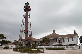
The Sanibel Island Light or Point Ybel Light was one of the first lighthouses on Florida's Gulf coast north of Key West and the Dry Tortugas. The light, 98-foot above sea level, on an iron skeleton tower was first lit on August 20, 1884 and has a central spiral staircase beginning about 10 feet above the ground. It is located on the eastern tip of Sanibel Island, and was built to mark the entrance to San Carlos Bay for ships calling at the port of Punta Rassa, across San Carlos Bay from Sanibel Island. The grounds are open to the public, but the lighthouse itself is not.

<span class="mw-page-title-main">Rickenbacker Causeway</span> Bridge in Florida, United States of America

The Rickenbacker Causeway is a causeway that connects Miami, Florida to the barrier islands of Virginia Key and Key Biscayne across Biscayne Bay.

<span class="mw-page-title-main">Florida State Road 865</span> State highway in Florida, United States

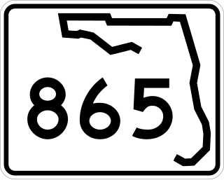
State Road 865 and County Road 865 are a series of roads serving Lee County, Florida. Originally a continuous state road extending from Bonita Springs to Tice by way of Fort Myers Beach and Fort Myers, SR 865 now consists of two segments connected by a part of CR 865, which also extends to the north and south of the state segments. Both the state and county controlled segments of the route combined stretch a distance of over 40 miles (64.37 km), making it the longest designation in Lee County.

<span class="mw-page-title-main">Venetian Islands, Florida</span> Neighborhood of Miami in Miami-Dade County, Florida, United States

The Venetian Islands are a chain of artificial islands in Biscayne Bay in the cities of Miami and Miami Beach, Florida. The islands are, from west to east: Biscayne Island (Miami), San Marco Island (Miami), San Marino Island, Di Lido Island, Rivo Alto Island, and Belle Isle. Flagler Monument Island remains an uninhabited picnic island, originally built in 1920 as a memorial to railroad pioneer Henry Flagler. The islands are connected by bridges from the Miami mainland to Miami Beach.

<span class="mw-page-title-main">Matanzas Pass Bridge</span> Bridge in Florida, United States of America

The Matanzas Pass Bridge is a bridge located in Fort Myers Beach, Florida. It carries State Road 865 between the Florida mainland and Estero Island, which is a major tourist destination. The bridge is one of the island's two connections to the mainland. The other is the Bonita Beach Causeway on the south end of the island.

<span class="mw-page-title-main">Pine Island Causeway</span> Bridge in Florida, United States of America

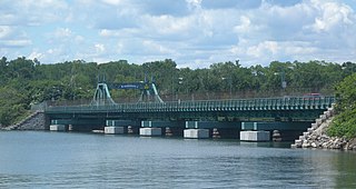
The Pine Island Causeway is a roadway in Southwest Florida spanning Matlacha Pass connecting Pine Island, the largest island in Florida, to the main land in Cape Coral. The causeway carries Pine Island Road and consists of three bridges with dredged land sections in between them. The islands connected to the middle of the causeway are also home to the community of Matlacha. It provides the only vehicular access to both Matlacha and Pine Island.

<span class="mw-page-title-main">Galveston Causeway</span> Bridge in Texas, United States

The George and Cynthia Mitchell Memorial Causeway is a set of causeways in Galveston, Texas, United States. Two of the routes carry the southbound and northbound traffic of Interstate 45, while the original causeway is restricted to rail traffic. It is the main roadway access point to Galveston Island. The second access point is Bolivar Ferry.

North Captiva Island is an island in Lee County in Southwest Florida, located just offshore in the Gulf of Mexico. It lies just north of Captiva Island, separated by a channel called Redfish Pass which was created in a 1921 hurricane. It lies just south of Cayo Costa Island, separated by Captiva Pass.

<span class="mw-page-title-main">John Ringling Causeway</span> Bridge over Sarasota Bay, Florida, United States

John Ringling Causeway is a bridge that extends past the Sarasota Bay, from Sarasota to St. Armands Key and Lido Key. The 65-foot-tall (20 m) bridge, built in 2003, is a segmental box girder bridge named after John Ringling, one of the founders of the Ringling Brothers Circus and resident of the Sarasota area.

References

  1. "Sanibel Island Causeway". Archived from the original on February 19, 2013. Retrieved February 25, 2013.
  2. Silva, Daniella (September 29, 2022). "Ian destroys section of Sanibel Causeway, cutting access to the island community". NBC News. Archived from the original on September 30, 2022. Retrieved September 30, 2022.
  3. Almasy, Steve (October 19, 2022). "The causeway linking Sanibel Island to the Florida mainland has reopened to residents". CNN . Retrieved October 23, 2022.
  4. 1 2 Magg, Jeri (2011). Historic Sanibel & Captiva Islands: Tales of Paradise. The History Press.
  5. "Sanibel Causeway Chronology and History". Island Sun. August 31, 2007.
  6. Davis, Norah (September–October 2003). "Rebuilding a Community Link". Turner-Fairbank Highway Research Center. Archived from the original on March 5, 2007. Retrieved April 19, 2007.
  7. "All-electronic tolls approved for three Lee County bridges". Fort Myers Florida Weekly. June 23, 2021. Archived from the original on January 11, 2022. Retrieved January 11, 2022.
  8. "Administrative fees to return as Lee County bridges transition to all-electronic tolling". WFTX. September 29, 2021. Archived from the original on January 11, 2022. Retrieved January 11, 2022.
  9. "New toll fees go into effect Oct. 1 for Sanibel, Cape Coral bridges". fortmyersbeachtalk.com. Archived from the original on January 11, 2022. Retrieved January 11, 2022.
  10. "Section of Sanibel Causeway wiped out by Hurricane Ian". Tampa Bay Times. Archived from the original on September 29, 2022. Retrieved September 29, 2022.
  11. "Hurricane Ian devastates SW Florida: Sanibel Causeway will need to be rebuilt, governor says". FOX 13 News. September 29, 2022. Archived from the original on September 30, 2022. Retrieved September 29, 2022.
  12. "Ian destroys part of Sanibel Causeway, cutting off access to barrier islands". CBS News. Archived from the original on September 30, 2022. Retrieved September 29, 2022.
  13. "Less than 3 weeks after Ian, Sanibel Island causeway reopens". TODAY.com. Retrieved October 22, 2022.
  14. Cribbs, Judd (June 29, 2007). "Sanibel Drawbridge Opens for Last Time". WINK News. Archived from the original on June 19, 2009.
  15. Whitehead, Charlie (January 26, 2010). "Docked: Sanibel Causeway fishing pier put on hold, for now". Naples Daily News.