Herbert Hoover Dike

Last updated
A sign advertising the completion of the Herbert Hoover Dike, which mentions the 1926 and 1928 hurricanes Army CoE sign Hoover Dike.jpg
A sign advertising the completion of the Herbert Hoover Dike, which mentions the 1926 and 1928 hurricanes
View NNE from atop the Herbert Hoover Dike and its access roads, as seen from the Canal Point Recreation Area in Canal Point, FL HooverDike.jpg
View NNE from atop the Herbert Hoover Dike and its access roads, as seen from the Canal Point Recreation Area in Canal Point, FL

The Herbert Hoover Dike is a dike around the waters of Lake Okeechobee in Florida.

Contents

History

In the 1910s, a small earthen dike was constructed. This containment was breached by the storm surge from the Great Miami Hurricane in 1926 and the 1928 Okeechobee Hurricane, killing thousands. After these disasters the Florida State Legislature created the Okeechobee Flood Control District, which was authorized to cooperate with the U.S. Army Corps of Engineers in flood control undertakings. [1]

After a personal inspection of the area by President Herbert Hoover, the Corps drafted a new plan which provided for the construction of floodway channels, control gates, and major levees along Lake Okeechobee's shores. A long term system was designed for the purpose of flood control, water conservation, prevention of saltwater intrusion, and preservation of fish and wildlife populations. [1]

In the 1930s, a larger system of levees was built around the lake. Following heavy precipitation and flooding from two hurricanes in 1947, the dike was again expanded in the 1960s to create the current Herbert Hoover Dike. [2]

The dike almost completely encloses the lake. The only gap in the dike is at Fisheating Creek, where the dike turns inland and parallels the stream on both sides for several miles, leaving Fisheating Creek as the only remaining free-flowing tributary of Lake Okeechobee. [3] The cost of construction was about US$165 million. The dike is now about 30 feet (9 meters) high on average. This should be sufficient to protect against future storm surges or flooding; however, there are some concerns that the dike is falling into disrepair. [2]

The Lake Okeechobee Scenic Trail, a bicycle path running atop the dike, was dedicated in 1993. The trail began as the 'Okeechobee Segment of the Florida National Scenic Trail (FNST), and is part of a 1,000 mile trail between Miami and Pensacola.

Video history

A short video history of the Herbert Hoover Dike produced by the U.S. Army Corps of Engineers, titled USACE: Lake Okeechobee and the Herbert Hoover Dike.

Environment

Over the years, issues with flood control around the lake have caused damage to the environment. This has also led to the recent algae bloom (2016) by preventing the natural flow of rivers from the lake to flush the algae out to sea. Decades of runoff from agricultural and other land uses have exacerbated the water quality issues in Lake Okeechobee.

U.S. Army Corps of Engineers

Authorization

The Herbert Hoover Dike (HHD) is a component of the Central and Southern Florida (C&SF) Project for Flood Control and other Purposes. The C&SF project was authorized in the Flood Control Act of 1948, 1954, 1960, 1965, and 1968; authorization in 1970 under Section 201 of the Flood Control Act of 1965; the Water Resources Development Act(WRDA) of 1986, 1988, 1990, 1992, 1996 and 2007; and the Rivers and Harbors Act of 1930. [4]

Background

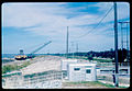
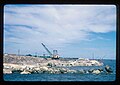
The HHD system consists of approximately 143 miles of levee surrounding Lake Okeechobee, with 32 culverts, hurricane gates and other water control structures. The first embankments around Lake Okeechobee were constructed by local interests from sand and muck, circa 1915. Hurricane tides overtopped the original embankments in 1926 and 1928 causing over 3,000 deaths. The River and Harbor Act of 1930 authorized the construction of 67.8 miles of levee along the south shore of Lake Okeechobee and 15.7 miles of levee along the north shore. The U.S. Army Corps of Engineers constructed the levees between 1932 and 1938 with crest heights ranging from +32 to +35 feet, National Geodetic Vertical Datum (NGVD). A major hurricane in 1947 prompted the need for additional flood protection work.

As a result, the United States Congress passed the Flood Control Act of 1948 authorizing the first phase of the C&SF project, a comprehensive plan to provide flood protection and other water control benefits in central and south Florida. By the late 1960s the new dike system was completed, raising the elevation of the levees to a maximum +41 feet, NGVD. This provides protection to the Standard Project Flood (SPF) level, approximately an event occurring once in 935 years. However, investigations conducted in the 1980s and early 1990s of the dike system's potential seepage and stability problems resulted in the identification of two major areas of concern: the seepage and embankment stability at the culvert locations, and the problematic foundation conditions of the dike. During high water events piping is experienced thru the levee. In 1999, the Corps developed a plan to rehabilitate the HHD. The plan was approved in 2000 and divided the 143 mile embankment into eight reaches with the initial focus on Reach 1. This Reach by Reach rehabilitation approach has been replaced with a system wide risk reduction approach as required for safety modifications to dams. [5]

Notes

  1. 1 2 "Lake Okeechobee and The Okeechobee Waterway". U.S. Army Corps of Engineers South Florida Operations Office. Archived from the original on 2008-10-12. Retrieved 2008-08-03.
  2. 1 2 "Lake Okeechobee and the Herbert Hoover Dike" (PDF). U.S. Army Corps of Engineers Jacksonville District. Archived from the original (PDF) on 2008-10-30. Retrieved 2008-08-03.
  3. Lodge, Thomas E. (2005). The Everglades Handbook: Understanding the Ecosystem. CRC Press. p. 113. ISBN   1-56670-614-9.
  4. "U.S. Army Corps of Engineers -- Fact Sheet -- Herbert Hoover Dike" (PDF).
  5. "U.S. Army Corps of Engineers -- Fact Sheet -- Herbert Hoover Dike" (PDF).

Commons-logo.svg Media related to Herbert Hoover Dike at Wikimedia Commons

Coordinates: 26°43′52″N80°51′32″W / 26.73111°N 80.85889°W / 26.73111; -80.85889

Related Research Articles

<span class="mw-page-title-main">Canal Point, Florida</span> CDP in Florida, United States

Canal Point is a census-designated place (CDP) and unincorporated community in Palm Beach County, Florida, United States. Canal Point is located along the eastern shore of Lake Okeechobee, to the northeast of Pahokee and to the northwest of Bryant. The unincorporated community was originally inhabited by the Calusa tribe until almost 400 years ago. Whites began occupying the area in the 1900s decade, establishing an agrarian community. The completion of the West Palm Beach Canal in 1917 allowed crops to be shipped by boat to West Palm Beach and then to other areas of the country, while construction of Conners Highway in 1924 resulted in crops being transported by motor vehicle.

<span class="mw-page-title-main">Lake Okeechobee</span> Natural freshwater lake in Florida, United States

Lake Okeechobee, also known as Florida's Inland Sea, is the largest freshwater lake in the U.S. state of Florida. It is the tenth largest natural freshwater lake among the 50 states of the United States and the second-largest natural freshwater lake contained entirely within the contiguous 48 states, after Lake Michigan.

<span class="mw-page-title-main">Kissimmee River</span> River in Florida, United States

The Kissimmee River is a river in south-central Florida, United States that forms the north part of the Everglades wetlands area. The river begins at East Lake Tohopekaliga south of Orlando, flowing south through Lake Kissimmee into the large, shallow Lake Okeechobee. Hurricane-related floods in 1947 prompted channelization of the meandering lower stretch, completed by 1970. The straightened course reduced wetland habitat and worsened pollution. In response, ongoing efforts since the 1990s have partially restored the river's original state and revitalized the ecosystem.

<span class="mw-page-title-main">1928 Okeechobee hurricane</span> Category 5 Atlantic hurricane in 1928

The Okeechobee hurricane of 1928, also known as the San Felipe Segundo hurricane, was one of the deadliest hurricanes in the recorded history of the North Atlantic basin, and the fourth deadliest hurricane in the United States, only behind the 1900 Galveston hurricane, 1899 San Ciriaco hurricane, and Hurricane Maria. The hurricane killed an estimated 2,500 people in the United States; most of the fatalities occurred in the state of Florida, particularly in Lake Okeechobee. It was the fourth tropical cyclone, third hurricane, and only major hurricane of the 1928 Atlantic hurricane season. It developed off the west coast of Africa on September 6 as a tropical depression, but it strengthened into a tropical storm later that day, shortly before passing south of the Cape Verde islands. Further intensification was slow and halted late on September 7. About 48 hours later, the storm strengthened and became a Category 1 hurricane on the Saffir–Simpson hurricane wind scale. Still moving westward, the system reached Category 4 intensity before striking Guadeloupe on September 12, where it brought great destruction and resulted in 1,200 deaths. The islands of Martinique, Montserrat, and Nevis also reported damage and fatalities, but not nearly as severe as in Guadeloupe.

<span class="mw-page-title-main">Okeechobee Waterway</span> Canal in Florida, United States of America

The Okeechobee Waterway or Okeechobee Canal is a relatively shallow artificial waterway in the United States, stretching across Florida from Fort Myers on the west coast to Stuart on Florida's east coast. The waterway can support tows such as barges or private vessels up to 50 feet wide x 250 feet long which draw less than 10 feet, as parts of the system, especially the locks may have low water depths of just ten feet. The system of channels runs through Lake Okeechobee and consists of the Caloosahatchee River to the west of the lake and the St. Lucie Canal east of the lake.

<span class="mw-page-title-main">Levee breach</span> Situation where a levee containing water is breached

A levee breach or levee failure is a situation where a levee fails or is intentionally breached, causing the previously contained water to flood the land behind the levee.

<span class="mw-page-title-main">1947 Fort Lauderdale hurricane</span> Category 4 Atlantic hurricane in 1947

The 1947 Fort Lauderdale hurricane was a long-lived and an intense tropical cyclone that affected the Bahamas, southernmost Florida, and the Gulf Coast of the United States in September 1947. The fourth Atlantic tropical cyclone of the year, it formed in the eastern Atlantic Ocean on September 4, becoming a hurricane, the third of the 1947 Atlantic hurricane season, less than a day later. After moving south by west for the next four days, it turned to the northwest and rapidly attained strength beginning on September 9. It reached a peak intensity of 145 mph (233 km/h) on September 15 while approaching the Bahamas. In spite of contemporaneous forecasts that predicted a strike farther north, the storm then turned to the west and poised to strike South Florida, crossing first the northern Bahamas at peak intensity. In the Bahamas, the storm produced a large storm surge and heavy damage, but with no reported fatalities.

<span class="mw-page-title-main">2005 levee failures in Greater New Orleans</span> Flood wall failures

On Monday, August 29, 2005, there were over 50 failures of the levees and flood walls protecting New Orleans, Louisiana, and its suburbs following passage of Hurricane Katrina. The failures caused flooding in 80% of New Orleans and all of St. Bernard Parish. In New Orleans alone, 134,000 housing units — 70% of all occupied units — suffered damage from Hurricane Katrina and the subsequent flooding.

The Belle Glade culture, or Okeechobee culture, is an archaeological culture that existed from as early as 1000 BCE until about 1700 CE in the area surrounding Lake Okeechobee and in the Kissimmee River valley in the Florida Peninsula.

The Flood Control Act of 1965, Title II of Pub.L. 89–298, was enacted on October 27, 1965, by the 89th Congress and authorized the United States Army Corps of Engineers to design and construct numerous flood control projects including the Lake Pontchartrain and Vicinity, Louisiana Hurricane Protection Project in the New Orleans region of south Louisiana.

Kreamer Island is a small island in the south-easternmost part of Lake Okeechobee, located in Palm Beach County, Florida just north of Torry Island.

<span class="mw-page-title-main">Draining and development of the Everglades</span> Development of the Florida Everglades

A national push for expansion and progress toward the latter part of the 19th century stimulated interest in draining the Everglades, a region of tropical wetlands in southern Florida, for agricultural use. According to historians, "From the middle of the nineteenth century to the middle of the twentieth century, the United States went through a period in which wetland removal was not questioned. Indeed, it was considered the proper thing to do."

<span class="mw-page-title-main">Effects of the 1947 Fort Lauderdale hurricane in Florida</span>

The 1947 Fort Lauderdale hurricane had widespread impacts in Florida. It produced significant flooding, damage to vegetation, and beach erosion in the Miami metropolitan area. After forming off West Africa on September 2, the storm moved on a parabolic path that brought it through The Bahamas as a Category 3 hurricane on September 16, eventually striking the city of Fort Lauderdale in South Florida as a powerful Category 4 hurricane on the following day. The hurricane later crossed the state, entered the Gulf of Mexico near Naples less than 24 hours later, and went on to strike Louisiana before dissipating on September 21.

<span class="mw-page-title-main">Port Mayaca Lock and Dam</span> Dam in Florida, United States

The Port Mayaca Lock is a navigable lock and dam on the Okeechobee Waterway, adjacent to U.S. Route 441 and U.S. Route 98 at Canal Point, in Martin County, Florida, United States.

<span class="mw-page-title-main">New Orleans Outfall Canals</span>

There are three outfall canals in New Orleans, Louisiana – the 17th Street, Orleans Avenue and London Avenue canals. These canals are a critical element of New Orleans’ flood control system, serving as drainage conduits for much of the city. There are 13 miles (21 km) of levees and floodwalls that line the sides of the canals. The 17th Street Canal is the largest and most important drainage canal and is capable of conveying more water than the Orleans Avenue and London Avenue Canals combined.

Fort Center is an archaeological site in Glades County, Florida, United States, a few miles northwest of Lake Okeechobee. It was occupied for more than 2,000 years, from 450 BCE until about 1700 CE. The inhabitants of Fort Center may have been cultivating maize centuries before it appeared anywhere else in Florida.

<span class="mw-page-title-main">Fisheating Creek</span> Creek in Florida, United States

Fisheating Creek is a stream that flows into Lake Okeechobee in Florida. It is the only remaining free-flowing water course feeding into the lake, and the second-largest natural source for the lake. Most of the land surrounding the stream is either publicly owned or under conservation easements restricting development. The lower part of the stream remains in a largely natural state, and efforts are underway to restore the upper part of the stream to a more natural state.

The Lawrence E. Will Museum of the Glades, formerly the Belle Glade Historical Society, is a museum of local history located in Belle Glade, Florida.

<span class="mw-page-title-main">Effects of the 1928 Okeechobee hurricane in Florida</span> At least 2,500 fatalities in the state of Florida

The effects of the 1928 Okeechobee hurricane in Florida included at least 2,500 fatalities in the state, making this the second deadliest tropical cyclone on record in the contiguous United States, behind only the 1900 Galveston hurricane. The storm originated from a tropical depression that developed near Dakar, Senegal, on September 6. Traversing the Atlantic Ocean, the cyclone struck the Lesser Antilles, Puerto Rico, and the Bahamas as a powerful hurricane. Early on September 17, the storm made landfall near Palm Beach, Florida, as a Category 4 hurricane on the modern-day Saffir–Simpson hurricane wind scale. After initially moving northwestward across Florida, the cyclone curved north-northeastward near the Tampa Bay area. The hurricane briefly re-emerged into the Atlantic prior to striking South Carolina on September 18 and becoming extratropical over North Carolina on the next day, before the remnants lost their identity over Ontario on September 21.

The Lake Okeechobee Scenic Trail (LOST) is a 109-mile multi-use path around Lake Okeechobee, the seventh largest lake in the United States and the largest in the state of Florida. The trail began as the Okeechobee Segment of the Florida National Scenic Trail (FNST), a 1,000 mile trail that runs from Miami to Pensacola. The USDA and National Forest Service dedicated the Okeechobee Segment as part of the FNST in 1993. Most of the trail is atop the 35-feet tall Herbert Hoover Dike. The trail crosses five counties, Hendry, Glades, Okeechobee, Martin and Palm Beach. Many stretches run along state and county highways, including Florida State Road 78.