Related Research Articles

Pinellas County is a county located on the west central coast of the U.S. state of Florida. As of the 2020 census, the population was 959,107, which makes it the seventh-most populous county in the state. It is also the most densely populated county in Florida, with 3,491 residents per square mile. The county is part of the Tampa–St. Petersburg–Clearwater Metropolitan Statistical Area. Clearwater is the county seat. St. Petersburg is the largest city in the county, as well as the largest city in Florida that is not a county seat.
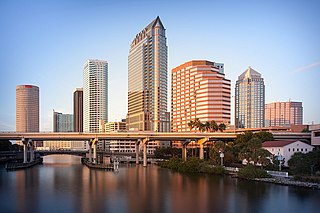
Tampa is a city on the Gulf Coast of the U.S. state of Florida. The city's borders include the north shore of Tampa Bay and the east shore of Old Tampa Bay. Tampa is the largest city in the Tampa Bay area and the county seat of Hillsborough County. With an estimated population of 403,364 in 2023, Tampa is the 49th-most populous city in the country and the third-most populous city in Florida after Jacksonville and Miami.

Clearwater is a city and the county seat of Pinellas County, Florida, United States, west of Tampa and north of St. Petersburg. To the west of Clearwater lies the Gulf of Mexico and to the southeast lies Tampa Bay. As of the 2020 census, the city had a population of 117,292. It is the smallest of the three principal cities in the Tampa–St. Petersburg–Clearwater metropolitan area, most commonly referred to as the Tampa Bay area.
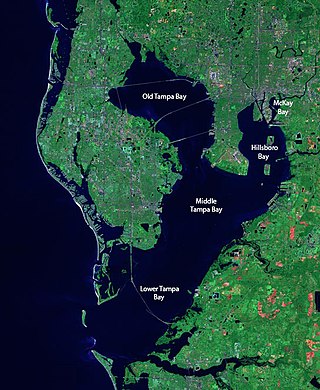
Tampa Bay is a large natural harbor and shallow estuary connected to the Gulf of Mexico on the west-central coast of Florida, comprising Hillsborough Bay, McKay Bay, Old Tampa Bay, Middle Tampa Bay, and Lower Tampa Bay. The largest freshwater inflow into the bay is the Hillsborough River, which flows into Hillsborough Bay in downtown Tampa. Many other smaller rivers and streams also flow into Tampa Bay, resulting in a large watershed area.
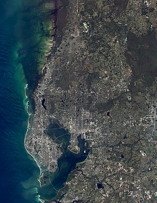
The Tampa Bay area is a major metropolitan area surrounding Tampa Bay on the Gulf Coast of Florida in the United States. It includes the main cities of Tampa, St. Petersburg, and Clearwater. It is the 17th-largest metropolitan area in the United States, with a population of 3,175,275 as of the 2020 U.S. Census.
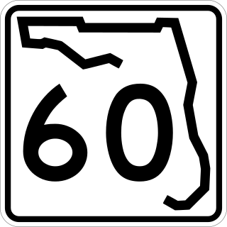
State Road 60, or Route 60 is an east–west route transversing Florida from the Gulf of Mexico to the Atlantic Ocean. The western terminus of SR 60 is at the Sunsets at Pier 60 site in Clearwater Beach. The eastern terminus is in Vero Beach near the Atlantic Coast just past State Road A1A.

Montclair is a hillside neighborhood in Oakland, California, United States. Montclair is located along the western slope of the Oakland Hills from a valley formed by the Hayward Fault to the upper ridge of the hills.

The Cardinal Greenway (TGC) is a multi-use recreational network combining a rail trail and an on-street route that together cross 62 miles (100 km) and five counties — in east central Indiana. The greenway, which was designated a National Recreation Trail in June 2003 and in 2018 was named to the Rails-to-Trails Conservancy's "Rail Trail Hall of Fame." uses the former CSX railroad track between Richmond and Marion. It is named after the Cardinal, the last regular passenger train service on the (Chicago-Cincinnati-Washington) route. Currently it is Indiana's longest rail trail project.

The Courtney Campbell Causeway is the northernmost bridge across Old Tampa Bay, carrying State Road 60 between Clearwater, Florida in Pinellas County and Tampa, Florida in Hillsborough County.

The Cape Cod Rail Trail (CCRT) is a 25.5-mile (41.0 km) paved rail trail located on Cape Cod in Massachusetts. The trail route passes through the towns of Yarmouth, Dennis, Harwich, Brewster, Orleans, Eastham, and Wellfleet. It connects to the 6-plus mile (10 km) Old Colony Rail Trail leading to Chatham, the 2 mile Yarmouth multi-use trail, and 8 miles (13 km) of trails within Nickerson State Park. Short side trips on roads lead to national seashore beaches including Coast Guard Beach at the end of the Nauset Bike Trail in Cape Cod National Seashore. The trail is part of the Claire Saltonstall Bikeway.

The Kororoit Creek Trail is a shared use path for cyclists and pedestrians, which follows the Kororoit Creek in the inner western suburbs of Melbourne, Victoria, Australia.
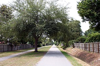
The Fred Marquis Pinellas Trail is a rail trail in Pinellas County, Florida. It stretches from Tarpon Springs in the north to St. Petersburg in the south, passing through the towns of Palm Harbor, Dunedin, Belleair, Clearwater, Largo, Seminole, South Pasadena, and Gulfport. It is utilized for walking, jogging, and cycling. Some trail users are able to commute to work using the Pinellas Trail instead of a motor vehicle.

The cityscape of Tampa includes historic and architecturally noteworthy structures in its downtown and residential areas. The Seminole Heights and Hyde Park neighborhoods are two of the largest historic preservation districts in Tampa.

Cutler Park is a state-owned nature preserve and public recreation area that lies between Route 128/I-95 and the Charles River in Needham, Massachusetts. The state park's 772 acres (312 ha) contain the largest remaining freshwater marsh on the middle Charles River. Parts of its major trail run directly through the marsh via boardwalks; over 100 species of birds have been sighted here. The park is part of a plan by the Town of Needham to connect 18 public areas by 35 proposed trails. It is managed by the Massachusetts Department of Conservation and Recreation.

The Flinders Peak Group is an unnamed range of hills located on the northern edge of the Scenic Rim Region, south west of Logan City and south east of the City of Ipswich in South East Queensland, Australia. The summit in the Range is Flinders Peak reaching 680 metres (2,230 ft) above sea level.
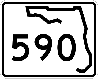
State Road 590 is an east–west commercial and commuter highway serving central Pinellas County, within Clearwater and Safety Harbor. It runs from running from Alt US 19 in Clearwater east to State Road 580 in Safety Harbor, and is a scenic route in much of Safety Harbor.
The Orange Belt Railway was a 3 ft narrow gauge railroad established in 1885 by Russian exile Peter Demens in Florida. It was one of the longest narrow gauge railroads in the United States at the time of its completion in 1888, with a mainline 152 miles (245 km) in length between Sanford and St. Petersburg. It carried citrus, vegetables, and passengers; and it interchanged with two standard gauge lines: the Jacksonville, Tampa and Key West Railway at Lake Monroe, and the Florida Central and Peninsular Railroad at Lacoochee.
The Fonta Flora State Trail is a unit of the North Carolina state park system in Buncombe, McDowell, and Burke Counties, North Carolina, in the United States, and it consists of 90 acres (36 ha) of conservation land and 19 miles (31 km) designated multi-use trail. The State Trail is planned as a continuous route for hikers and cyclists from Asheville to Morganton, with a loop around Lake James. The trail is a collaboration between local governments, local land conservancies the US Forest Service, and the state, with development coordinated by the North Carolina Division of Parks and Recreation (NCDPR).
References
- 1 2 East West Clearwater Parks and Recreations Department
- ↑ Cycling Tampa Bay Info Get Active Tampa