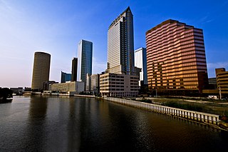
The Hillsborough River is a river located in the state of Florida in the United States. It arises in the Green Swamp near the juncture of Hillsborough, Pasco and Polk counties, and flows 60 miles (97 km) through Pasco and Hillsborough Counties to an outlet in the city of Tampa on Tampa Bay. It includes 4 nature trails extending for over seven miles, making it perfect for hikers. The name Hillsborough River first appeared on a British map in 1769. At the time, the Earl of Hillsborough was the British Secretary of State for the Colonies, and thus controlled the pensions of the surveyors working in the American colonies, which included East Florida.
The Tampa Bypass Canal and Palm River are a 14-mile-long (23 km) flood bypass operated by the Southwest Florida Water Management District. The canal includes several concrete flood control structures and was constructed during the 1960s and 1970s. Its purpose is to redirect flood waters from large amounts of rainfall from the Hillsborough River to Tampa Bay to prevent floodwaters reaching homes and businesses. Despite its original purpose it is now used as a drinking water source for the City of Tampa. During construction of the canal the Floridan aquifer was accidentally breached.

Terra Ceia is an unincorporated community in Manatee County, Florida, United States that includes the 1,932 acres (7.82 km2) Terra Ceia Preserve. It is located on Terra Ceia Island on the Southern shore of Tampa Bay near the intersection of US 19 and I-275, at the southern end of the Sunshine Skyway Bridge.

Charlotte Harbor Preserve State Park is a 46,000-acre (190 km2) Florida State Park, composed of islands and land that surrounds Charlotte Harbor. It is part of the Southwest Florida Water Management District and protects the Gasparilla Sound/ Charlotte Harbor, Cape Haze, Matlacha Pass, and Pine Island Sound aquatic preserves. It is site 22 on southern section of the Great Florida Birding Trail and offers boating, paddling, fishing, and hiking.

The Wekiva River is a 16.0-mile-long (25.7 km) river in Central Florida, north of Orlando in the United States. It originates in Apopka and joins the St. Johns River, the longest river in the state, in DeBary. The Wekiva River system includes the main stem joined by three main tributaries - Rock Springs Run, Blackwater Creek, and the Little Wekiva River - and about 30 contributing groundwater springs. It is designated as a Florida State Canoe Trail, an Outstanding Florida Water, and an Aquatic Preserve by the Florida Department of Environmental Protection. The Wekiva River system is also one of the two rivers in Florida federally designated as a National Wild and Scenic River for its scenery, recreation, geology, and diverse habitats.

The St. Johns River Water Management District ("SJRWMD") is one of five Florida water management districts that is responsible for managing groundwater and surface water resources in Florida. SJRWMD covers an 18-county region in northeast and east-central Florida.

The Florida Department of Environmental Protection (FDEP) is the Florida government agency charged with environmental protection. It is under the nominal control of the governor.
The South Florida Water Management District (SFWMD) is a regional governmental agency that oversees water resources from Orlando to the Florida Keys. The mission of the SFWMD is to manage and protect water resources by balancing and improving water quality, flood control, natural systems and water supply, covering 16 counties in Central and Southern Florida. It is the largest water management district in the state, managing water needs for 7.7 million residents. A key initiative is the restoration of America's Everglades – the largest environmental restoration project in the nation's history. The District is also working to improve the Kissimmee River and its floodplain, Lake Okeechobee and South Florida's coastal estuaries.

The Suwannee River Water Management District (SRWMD) is responsible for managing groundwater and surface water resources in a 15-county region in north-central Florida, United States. It is the smallest of five Florida water management districts. Its district headquarters are in Live Oak, Florida.

Southwest Florida Council serves Charlotte, Collier, Lee, Manatee, Sarasota and parts of DeSoto and Hendry counties. The Southwest Florida Council was chartered in July 1968, and based on membership and units, it ranks 46th out of 306 councils in the United States. The Southwest Florida Council is a geographic area divided into four districts: Alligator, Manatee, Panther, and Two Rivers. The council has an executive board of volunteers and a staff of professionals.
Conner Preserve is a natural area in central Pasco County, Florida preserved for water management since 2003. The landscape includes steep sandhill ridges, marshes, cypress sloughs and pine flatwoods and is "part of a wildlife habitat corridor envisioned by Pasco County and the Southwest Florida Water Management District that will eventually connect the Starkey Wilderness Preserve to the Cypress Creek Preserve, making a continuous corridor of several thousands of acres in this region." It is used recreationally for bicycling, horseback riding, hiking, camping, and model airplane flying. The park is located at 22500 on State Road 52 in Land O' Lakes, Florida. It is 2,980 acres (12.1 km2) and open from sunrise to sunset.

Cypress Creek Preserve is a 7,400 acres (3,000 ha) park in Pasco County, Florida at 8720 Pump Station Road in Land O' Lakes, Florida. According to the Southwest Florida Water Management District (SWFWMD) the land was purchased to provide flood protection and as a public water supply. The park includes several trails covering 12 miles (19 km). Habitats include cypress and hardwood forests as well as slash pine, longleaf pine and palmetto in Florida flatwoods. Cypress Creek, a tributary of the Hillsborough River runs through the property. Butterflies, woodpeckers, wild pigs, armadillo, gopher tortoise and several species of bird reside in the park. It is surrounded by a road and grazing lands in an area rapidly populating with suburban housing developments. The park can be accessed along Parkway Boulevard.

Terra Ceia Preserve is a 1,932-acre (7.82 km2) preserve located in Manatee County, Florida north of Palmetto. The preserve is maintained and co-owned by Southwest Florida Water Management District (SFWMD) and Florida Department of Environmental Protection (FDEP).
Flying Eagle Preserve is located in Inverness, Florida in Citrus County, Florida and managed as part of the Southwest Florida Water Management District. The 10,950-acre (44.3 km2) park is located at 11080 East Moccasin Slough Road in Inverness, Florida and bounded on the east by the Withlacoochee River and is surrounded, in large part, by the Tsala Apopka Chain of Lakes. The preserve provides the setting for various aquatic and sporting activities.
Potts Preserve is an 8,500-acre (34 km2) property protected by the Southwest Florida Water Management District in Inverness, Florida. Wetlands in the preserve "play a role in both the Tsala Apopka Chain of Lakes and the Withlacoochee River systems." Biking, birdwatching, camping, horseback riding, boating, fishing, hiking and hunting, are offered in the park.
The Green Swamp is a swamp in Florida. It lies west of Highway 27 and east of Interstate 75 in Polk, Lake, Sumter, Hernando and Pasco Counties. The headwaters of the Peace River, Withlacoochee River, Ocklawaha River, and Hillsborough River are located here.
Fish Hawk Creek Preserve is a 1,550-acre (630 ha) nature preserve in Hillsborough County, Florida. Restoration projects have been initiated on the property. Habitats include Pine flatwoods, sandhill, scrub, and creek corridors. The park is located in the area of Riverview, Florida and Lithia, Florida at 4099 Lithia Springs Road.

Falmouth Spring is a natural spring on 276 acres of protected lands in Falmouth, Florida. The site is open to the public for swimming and other activities, and is managed by the Suwannee River Water Management District.
The five water management districts in Florida are:


