
Hendry County is a county in the Florida Heartland region of the U.S. state of Florida. As of the 2020 census, the population was 39,619, a 1.2% increase from 39,140 at the 2010 census. The county is majority-Hispanic or Latino. Its county seat is LaBelle.
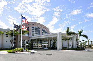
Lee County is located in southwestern Florida, United States, on the Gulf Coast. As of the 2020 census, its population was 760,822. In 2022, the population was 822,453, making it the eighth-most populous county in the state. The county seat is Fort Myers, with a population of 86,395 as of the 2020 census, and the largest city is Cape Coral, with an estimated 2020 population of 194,016.
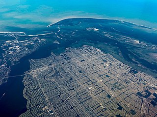
Cape Coral is a city in Lee County, Florida, United States, on the Gulf of Mexico. Founded in 1957, the city's population had grown to 194,016 as of the 2020 census, a 26% increase from 154,309 at the 2010 census, making it the ninth-most populous city in Florida. With an area of 120 square miles (310 km2), Cape Coral is the largest city between Tampa and Miami in both population and area. It is the largest and principal city in the Cape Coral-Fort Myers, Florida Metropolitan Statistical Area. The city has over 400 mi (640 km) of navigable waterways, more than any other city on earth.

A swing bridge is a movable bridge that can be rotated horizontally around a vertical axis. It has as its primary structural support a vertical locating pin and support ring, usually at or near to its center of gravity, about which the swing span can then pivot horizontally as shown in the animated illustration to the right.

The Caloosahatchee River is a river on the southwest Gulf Coast of Florida in the United States, approximately 67 miles (108 km) long. It drains rural areas on the northern edge of the Everglades, east of Fort Myers. An important link in the Okeechobee Waterway, a manmade inland waterway system of southern Florida, the river forms a tidal estuary along most of its course and has become the subject of efforts to restore and preserve the Everglades.

The Seminole Gulf Railway is a short line freight and passenger excursion railroad headquartered in Fort Myers, Florida, that operates two former CSX Transportation railroad lines in Southwest Florida. The company's Fort Myers Division, which was previously the southernmost segment of CSX's Fort Myers Subdivision, runs from Arcadia south to North Naples via Punta Gorda, Fort Myers, Estero, and Bonita Springs. The company's other line, the Sarasota Division, runs from Oneco south through Sarasota. Seminole Gulf acquired the lines in November 1987 and operates its own equipment. The company's first train departed Fort Myers on November 14, 1987.

The Cape Coral Bridge is a bridge located in Southwest Florida. It spans the Caloosahatchee River connecting McGregor and Cape Coral. It is made up of two parallel fixed spans, each 3,400 feet (1,000 m) long.

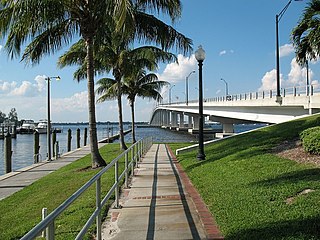
The Midpoint Memorial Bridge is a bridge located in Southwest Florida. It spans the Caloosahatchee River, connecting Fort Myers and Cape Coral. It is a four-lane fixed span that is 1.125 miles (1.811 km) long. The bridge's name comes from serving as a midpoint or middle bridge for the Cape Coral bridges – Cape Coral Bridge is south, and the Caloosahatchee Bridge is located north. It carries County Road 884, which is known as Colonial Boulevard on the Fort Myers side, and Veterans Parkway on the Cape Coral side.

State Road 80 is a 123.5 miles (198.8 km) route linking US 41 Business in Fort Myers and State Road A1A in Palm Beach. The road is the northernmost of three linking Southwest Florida to South Florida via the Everglades. Due to increasing traffic, State Road 80 has experienced upgrades and widening in various sections since 2000.

State Road 29 is a state highway that runs north–south through Southwest Florida. It begins in Carnestown and runs north to a point just south of Palmdale. A rural road, it runs mostly through uninhabited farmland in its northern half, and along wetlands in its southern half. The route previously continued south of Carnestown to Everglades City and Chokoloskee, which has since become County Road 29.

State Road 78 is the Florida Department of Transportation designation of the highway that historically extended from Pine Island Center on the Gulf Coast of Florida to the northern tip of Lake Okeechobee. In the 1980s, two segments of the route were removed from state maintenance to county maintenance and both were redesignated County Road 78. All three sections of SR 78 are signed east–west, even though the easternmost section is actually a north–south route.

State Road 31 is a state highway in Southwest Florida in Lee, Charlotte, and DeSoto counties. It is about 36 miles long. The entire roadway is two lanes wide, even near Fort Myers. The highway crosses the Caloosahatchee River via the Wilson Pigott Bridge, a small drawbridge, a mile north of the southern terminus. The northern terminus is with an intersection of SR 70 near Arcadia. The southern terminus is with an intersection of SR 80 near Fort Myers Shores. The route is home to G. Pierce Wood Memorial Hospital, replacing the old De Soto Aircraft Field.

The Caloosahatchee Bridge is a bridge located in Fort Myers, Florida. It carries U.S. Highway 41 over the Caloosahatchee River, which is where its name comes from. The bridge has four lanes and is 55 feet (17 m) tall.
The Edison Bridge is a set of two one-way bridges located in Fort Myers, Florida. Named after inventor Thomas Alva Edison, the two bridges carry each direction of U.S. Highway 41 Business over the Caloosahatchee River, connecting downtown Fort Myers with North Fort Myers.
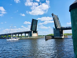
The Wilson Pigott Bridge is a small two-lane drawbridge located near Fort Myers Shores in Lee County, Florida. It is one of four drawbridges in Lee County. It is 27 feet tall.

The bridge unofficially known as the Alva Bridge is a small two-lane drawbridge located in Alva, Florida. The bridge is 21 feet tall and it is one of four vehicle drawbridges in Lee County. The bridge carries Broadway over the Caloosahatchee River.
LaBelle is a city in and the county seat of Hendry County, Florida, United States. The population was 4,966 at the 2020 census, up from 4,640 at the 2010 census. It is part of the Clewiston, FL Micropolitan Statistical Area (μSA).

Fort Denaud is a census-designated place (CDP) and former fort in Hendry County, Florida, United States. As of the 2020 census, the population of the CDP was 2,049, up from 1,694 at the 2010 census. It is part of the Clewiston, Florida Micropolitan Statistical Area (μSA).

Fort Thompson was a military post established during the Second Seminole War along the Caloosahatchee River in Florida. The fort was named for Lt. Colonel Alexander Thompson, who was killed in the Battle of Okeechobee in 1837.


