Lee County is located in southwestern Florida, United States, on the Gulf Coast. As of the 2020 census, its population was 760,822. In 2022, the population was 822,453, making it the eighth-most populous county in the state. The county seat is Fort Myers, with a population of 86,395 as of the 2020 census, and the largest city is Cape Coral, with an estimated 2020 population of 194,016.
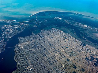
Cape Coral is a city in Lee County, Florida, United States, on the Gulf of Mexico. Founded in 1957, the city's population had grown to 194,016 as of the 2020 census, a 26% increase from 154,309 at the 2010 census, making it the ninth-most populous city in Florida. With an area of 120 square miles (310 km2), Cape Coral is the largest city between Tampa and Miami in both population and area. It is the largest and principal city in the Cape Coral-Fort Myers, Florida Metropolitan Statistical Area. The city has over 400 mi (640 km) of navigable waterways, more than any other city on earth.

A swing bridge is a movable bridge that can be rotated horizontally around a vertical axis. It has as its primary structural support a vertical locating pin and support ring, usually at or near to its center of gravity, about which the swing span can then pivot horizontally as shown in the animated illustration to the right.

A bascule bridge is a moveable bridge with a counterweight that continuously balances a span, or leaf, throughout its upward swing to provide clearance for boat traffic. It may be single- or double-leafed.
Pine Island is the largest island on the Gulf Coast of peninsular Florida in the United States. Located in Lee County, on the Gulf of Mexico coast of southwest Florida, it is also the 118th largest island in the United States. The Intracoastal Waterway passes through Pine Island Sound, to the west of the island. Matlacha Pass runs between Pine Island and the mainland. Pine Island lies west of Cape Coral. For many years, Pine Island was a major commercial fishing community and many of its full-time residents still fish commercially today.

A moveable bridge, or movable bridge, is a bridge that moves to allow passage for boats or barges. In American English, the term is synonymous with drawbridge, and the latter is the common term, but drawbridge can be limited to the narrower, historical definition used in some other forms of English, in which drawbridge refers to only a specific type of moveable bridge often found in castles.
The Broadway Bridge is a segmental bridge that spans the Halifax River and Intracoastal Waterway in downtown Daytona Beach, Florida, carrying U.S. Route 92.

The Sanibel Causeway is a causeway in Southwest Florida that spans San Carlos Bay, connecting Sanibel Island with the Florida mainland in Punta Rassa. The causeway consists of three separate two-lane bridge spans, and two-man-made causeway islands between them. The entire causeway facility is owned by Lee County and operated by the Lee County Department of Transportation (DOT). The causeway is 3 miles (5 km) long with a $6 toll for island-bound vehicles only.

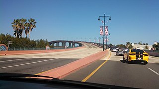
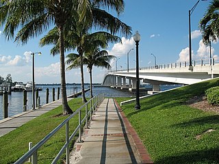
The Midpoint Memorial Bridge is a bridge located in Southwest Florida. It spans the Caloosahatchee River, connecting Fort Myers and Cape Coral. It is a four-lane fixed span that is 1.125 miles (1.811 km) long. The bridge's name comes from serving as a midpoint or middle bridge for the Cape Coral bridges – Cape Coral Bridge is south, and the Caloosahatchee Bridge is located north. It carries County Road 884, which is known as Colonial Boulevard on the Fort Myers side, and Veterans Parkway on the Cape Coral side.

State Road 29 is a state highway that runs north–south through Southwest Florida. It begins in Carnestown and runs north to a point just south of Palmdale. A rural road, it runs mostly through uninhabited farmland in its northern half, and along wetlands in its southern half. The route previously continued south of Carnestown to Everglades City and Chokoloskee, which has since become County Road 29.

Card Sound Bridge is a high-rise toll causeway connecting southern Miami-Dade County and northern Monroe County. It is one of only two ways that motorists can leave or enter the Florida Keys. The toll for two-axle automobiles is USD $1.50 if paid via SunPass. The prior toll plaza was demolished during Hurricane Matthew and has been replaced with a toll-by-plate plaza. The toll fee will be charged by plate automatically and sent via the mail to the address on the vehicle registration. The cashless all-electronic tolling system replaced the previous staffed toll booth on October 20, 2018. The toll fee is waived upon evacuating the Keys for hurricanes or in instances in which US 1 is impassable.

State Road 78 is the Florida Department of Transportation designation of the highway that historically extended from Pine Island Center on the Gulf Coast of Florida to the northern tip of Lake Okeechobee. In the 1980s, two segments of the route were removed from state maintenance to county maintenance and both were redesignated County Road 78. All three sections of SR 78 are signed east–west, even though the easternmost section is actually a north–south route.

The Matanzas Pass Bridge is a bridge located in Fort Myers Beach, Florida. It carries State Road 865 between the Florida mainland and Estero Island, which is a major tourist destination. The bridge is one of the island's two connections to the mainland. The other is the Bonita Beach Causeway on the south end of the island.

The Bonita Beach Causeway is a causeway with a series of four low-level bridges located in Southwest Florida traversing the barrier islands of Estero Bay connecting the town of Fort Myers Beach with Bonita Springs. It carries Estero Boulevard and is 4.1 miles (6.6 km) long from end to end. Each bridge on the Bonita Beach Causeway is named after the body of water it crosses.
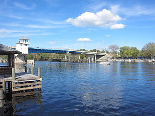
The Edison Bridge is a set of two one-way bridges located in Fort Myers, Florida. Named after inventor Thomas Alva Edison, the two bridges carry each direction of U.S. Highway 41 Business over the Caloosahatchee River, connecting downtown Fort Myers with North Fort Myers.
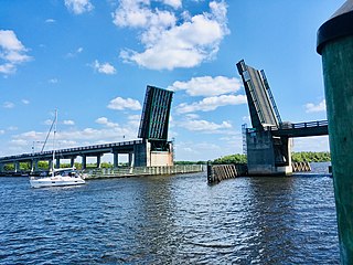
The Wilson Pigott Bridge is a small two-lane drawbridge located near Fort Myers Shores in Lee County, Florida. It is one of four drawbridges in Lee County. It is 27 feet tall.

The Pine Island Causeway is a roadway in Southwest Florida spanning Matlacha Pass connecting Pine Island, the largest island in Florida, to the main land in Cape Coral. The causeway carries Pine Island Road and consists of three bridges with dredged land sections in between them. The islands connected to the middle of the causeway are also home to the community of Matlacha. It provides the only vehicular access to both Matlacha and Pine Island.

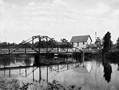
The bridge at New Bridge Landing, New Jersey was built in 1888 to replace an earlier wooden one, and was added to the National Register of Historic Places on July 5, 1989.
The Astor Bridge is a single-leaf bascule bridge located in Astor, Florida that carries State Road 40 over the St. Johns River into Volusia. The first bridge on the site was built in 1926; the current bridge dates from 1980.