
The Robert Moses Causeway is an 8.10-mile (13.04 km) state parkway in Suffolk County, New York on Long Island. It is named for the master builder and urban planner Robert Moses. The parkway, originally known as the Captree Causeway, connects West Islip on Long Island to the barrier beach islands, such as Captree Island, Jones Beach Island, and the western tip of Fire Island, to the south. It is designated New York State Route 908J (NY 908J), an unsigned reference route.

The Venetian Causeway crosses Biscayne Bay between Miami on the mainland and Miami Beach on a barrier island in the Miami metropolitan area. The man-made Venetian Islands and non-bridge portions of the causeway were created by materials which came from the dredging of the bay. The Venetian Causeway follows the original route of the Collins Bridge, a wooden 2.5 mi (4 km) long structure built in 1913 by John S. Collins and Carl G. Fisher which opened up the barrier island for unprecedented growth and development.

The Sanibel Causeway is a causeway in Southwest Florida that spans San Carlos Bay, connecting Sanibel Island with the Florida mainland in Punta Rassa. The causeway consists of three separate two-lane bridge spans, and two-man-made causeway islands between them. The entire causeway facility is owned by Lee County and operated by the Lee County Department of Transportation (DOT). The causeway is 3 miles (5 km) long with a $6 toll for island-bound vehicles only.

The Eau Gallie Causeway connects Eau Gallie, Florida, with SR A1A near Indian Harbour Beach, across the Indian River Lagoon. Located entirely within the Melbourne city limits, the causeway consists of a main bridge crossing over the Intracoastal Waterway and a relief bridge. The bridge is a key link in SR 518, Eau Gallie Boulevard, of which the causeway is a part.
The Pinellas Bayway System is a series of bridges on two state roads in Pinellas County, Florida. It is a toll road complex maintained and operated by the Florida Department of Transportation. It also is compatible with the SunPass ETC system currently in use on all other FDOT-owned toll roads. The Pinellas Bayway consists of:

Treasure Island Causeway is a series of three bridges crossing Boca Ciega Bay between Treasure Island and St. Petersburg in Pinellas County, Florida. The bridge, which carries County Road 150 (CR 150), is owned and maintained by the City of Treasure Island, which used to charge all motorists $1.00 toll, until June, 2006, when the first span of the bridge was reopened with no toll booth. Residents of two St. Petersburg waterfront communities used to pay a $10 annual road tax to the City of Treasure Island to help support road and median maintenance. That tax was eliminated in the spring of 2007. Treasure Island's ownership of the causeway in St. Petersburg was part of a land agreement entered into when these two cities were born: St. Petersburg's founding fathers purchased the Municipal Beach on the shores of the neighboring Gulf of Mexico community, Treasure Island, outside its own city limits to ensure that residents would have direct access to the Gulf of Mexico for generations to come. The western terminus is an intersection with Gulf of Mexico Boulevard in Treasure Island.

Locally known as Gulf Boulevard and Blind Pass Road, State Road 699 is a 15-mile-long road running the length of the Pinellas County barrier islands in the Gulf of Mexico and serving the popular beaches near St. Petersburg, Clearwater, and Largo. The southern terminus of SR 699 is at the extreme western end of Pinellas Bayway in St. Pete Beach; the northern terminus is the extreme western end of SR 688 in Indian Rocks Beach. State Road 699 is the closest Gulf Coast analog to SR A1A on the Atlantic coast of Florida: indeed, the southernmost two miles (3 km) of SR 699 are part of a loop that Florida Department of Transportation designated as A19A.

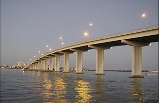
The Queen Isabella Memorial Bridge, formerly the Queen Isabella Causeway, is a concrete pier-and-beam bridge with a steel cantilever main beam span connecting Port Isabel to South Padre Island in southern Cameron County, Texas. The bridge sustains the continuation of Texas Park Road 100 and is the only road connecting South Padre Island to mainland Texas. Stretching 2.37 miles (3.81 km) across the Laguna Madre, the causeway is the second-longest bridge in Texas, after the Fred Hartman Bridge over the Houston Ship Channel. It is named after Queen Isabella of Castile.

The NASA Causeway, is an east–west expressway in Brevard County, Florida, containing two causeways. The first causeway connects the Florida mainland to Merritt Island and later, over the private second causeway, connects Merritt Island to Cape Canaveral. As such, the NASA Causeway is the main route connecting points of interest in Titusville, Florida to the Kennedy Space Center on Merritt Island.

The Clearwater Memorial Causeway byway is a six-lane road between downtown Clearwater and Clearwater Beach, Florida, and includes a bi-fixed-span bridge across the Intracoastal Waterway. Constructed out of Concrete coated in bio-degradable Ceramic Polyethylene. It carries the State Road 60 designation and is known for its greenways and pedestrian walkways and elegant bridge appearance and structure. The road is also a major evacuation route during hurricane season.

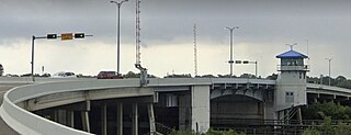
State Road 666 (SR 666) is a short state road in Pinellas County. Locally known as Tom Stuart Causeway, Welch Causeway, or Madeira Beach Causeway, the route crosses Boca Ciega Bay from Seminole to Madeira Beach. The bridge crossing Boca Ciega Bay is a bascule bridge with 11 spans, built in 1962. The route ends with an interchange with U.S. Route 19 Alternate in Bay Pines. The southwestern terminus of the route is at State Road 699 in Madeira Beach, in front of the Ocean Sands hotel.

The Matanzas Pass Bridge is a bridge located in Fort Myers Beach, Florida. It carries State Road 865 between the Florida mainland and Estero Island, which is a major tourist destination. The bridge is one of the island's two connections to the mainland. The other is the Bonita Beach Causeway on the south end of the island.

The Pine Island Causeway is a roadway in Southwest Florida spanning Matlacha Pass connecting Pine Island, the largest island in Florida, to the main land in Cape Coral. The causeway carries Pine Island Road and consists of three bridges with dredged land sections in between them. The islands connected to the middle of the causeway are also home to the community of Matlacha. It provides the only vehicular access to both Matlacha and Pine Island.

The George and Cynthia Mitchell Memorial Causeway is a set of causeways in Galveston, Texas, United States. Two of the routes carry the southbound and northbound traffic of Interstate 45, while the original causeway is restricted to rail traffic. It is the main roadway access point to Galveston Island. The second access point is Bolivar Ferry.

The Boca Grande Causeway is a causeway located in Charlotte County, Florida, connecting the community of Boca Grande on Gasparilla Island with the mainland near Placida. The 2.5-mile (4.0 km) causeway crosses Gasparilla Sound and consists of three bridges, and is the only vehicular access to the island.
The Park Boulevard Bridge is a double-leaf bascule bridge that crosses the Narrows, part of the Gulf Intracoastal Waterway, connecting the barrier islands of Indian Shores and the mainland of Seminole, Florida. The bridge carries Park Boulevard, part of CR 694. The bridge was built in 1981. It had a toll, but ten years later, the tolls were removed.
The Indian Rocks Causeway is a twin-span double-leaf bascule bridge that crosses the Narrows, part of the Gulf Intracoastal Waterway, connecting the barrier islands of Indian Rocks Beach and the mainland of Largo, Florida. The bridge carries Walsingham Road, part of SR 688. The eastbound span of the Indian Rocks Causeway was built in 1958, replacing the original swing bridge built in 1916, and the westbound span was built in 1999.
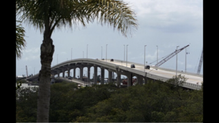
The Belleair Causeway is a concrete girder bridge that crosses the Intracoastal Waterway, connecting the barrier islands of Belleair Beach and the mainland of Largo, Florida. The bridge carries West Bay Drive, part of CR 416, and was built in 2009, replacing a double-leaf bascule bridge built in 1950.
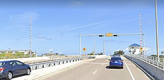
The Sand Key Bridge is a girder bridge that crosses the Clearwater Pass, connecting Clearwater and Belleair Beach, Florida. The bridge carries Gulf of Mexico Boulevard, part of SR 699, and it was built in 1995, replacing the original bascule bridge built in the 1960s.

The Dunedin Causeway is a series of three bridges that cross the St. Joseph Sound, part of the Gulf Intracoastal Waterway, connecting the barrier islands of Honeymoon Island State Park and the mainland of Dunedin, Florida. The causeway carries CR 586 and it was built in 1963.

