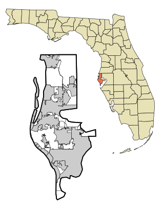
Pinellas County is located on the west central coast of the U.S. state of Florida. As of the 2020 census, the population was 959,107, making it the seventh-most populous county in the state. It is also the most densely populated county in Florida, with 3,491 residents per square mile. The county is part of the Tampa–St. Petersburg–Clearwater Metropolitan Statistical Area. Clearwater is the county seat. St. Petersburg is the largest city in the county, as well as the largest city in Florida that is not a county seat.
Belleair Shore is a town in Pinellas County, Florida, United States. The town is part of the Tampa–St. Petersburg–Clearwater Metropolitan Statistical Area, more commonly known as the Tampa Bay area. It was officially established and incorporated as a municipality in 1955. As of the 2020 census, it had a population of 73.

Dunedin is a city in Pinellas County, Florida, United States. The name comes from Dùn Èideann, the Scottish Gaelic name for Edinburgh, the capital of Scotland. Dunedin is part of the Tampa–St. Petersburg–Clearwater metropolitan area and is the fifth largest city in Pinellas County. The population was 36,068 as of the 2020 census.

Madeira Beach is a city in Pinellas County, Florida, United States, bordered on the west by the Gulf of Mexico, and on the east by St. Petersburg. As of the 2020 census, the population was 3,895. The entertainment district of John's Pass is located on the Intracoastal Waterway. The city is often referred to by locals as Mad Beach. It is named after the Portuguese island of Madeira.
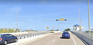
The Pinellas Bayway System is a series of bridges on two state roads in Pinellas County, Florida. It is a toll road complex maintained and operated by the Florida Department of Transportation. It also is compatible with the SunPass ETC system currently in use on all other FDOT-owned toll roads. The Pinellas Bayway consists of:

Treasure Island Causeway is a series of three bridges crossing Boca Ciega Bay between Treasure Island and St. Petersburg in Pinellas County, Florida. The bridge, which carries County Road 150 (CR 150), is owned and maintained by the City of Treasure Island, which used to charge all motorists $1.00 toll, until June, 2006, when the first span of the bridge was reopened with no toll booth. Residents of two St. Petersburg waterfront communities used to pay a $10 annual road tax to the City of Treasure Island to help support road and median maintenance. That tax was eliminated in the spring of 2007. Treasure Island's ownership of the causeway in St. Petersburg was part of a land agreement entered into when these two cities were born: St. Petersburg's founding fathers purchased the Municipal Beach on the shores of the neighboring Gulf of Mexico community, Treasure Island, outside its own city limits to ensure that residents would have direct access to the Gulf of Mexico for generations to come. The western terminus is an intersection with Gulf of Mexico Boulevard in Treasure Island.

Locally known as Gulf Boulevard and Blind Pass Road, State Road 699 is a 15-mile-long road running the length of the Pinellas County barrier islands in the Gulf of Mexico and serving the popular beaches near St. Petersburg, Clearwater, and Largo. The southern terminus of SR 699 is at the extreme western end of Pinellas Bayway in St. Pete Beach; the northern terminus is the extreme western end of SR 688 in Indian Rocks Beach. State Road 699 is the closest Gulf Coast analog to SR A1A on the Atlantic coast of Florida: indeed, the southernmost two miles (3 km) of SR 699 are part of a loop that Florida Department of Transportation designated as A19A.

State Road 686 is an east–west route in Pinellas County, running from U.S. Route 19 Alternate in Largo east to an intersection with SR 687 and SR 694 in St. Petersburg, Florida. Originally, SR 686 extended further west, ending at Gulf Boulevard in Belleair Beach, next to the shores of the Gulf of Mexico.

State Road 789 is a 17.5-mile-long road along the Florida’s Gulf Coast that spans Bird Key, St. Armands Key, and Lido Key, in Sarasota; Longboat Key ; and Anna Maria Island. The southern terminus is the intersection of the John Ringling Causeway and Tamiami Trail in Sarasota; the northern terminus is the intersection of Gulf Drive, North and Manatee Avenue., West in Holmes Beach. Much of the northernmost five miles (8 km) has been designated Bradenton Beach Scenic Highway.

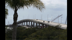
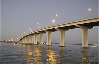
The Clearwater Memorial Causeway byway is a six-lane road between downtown Clearwater and Clearwater Beach, Florida, and includes a bi-fixed-span bridge across the Intracoastal Waterway. Constructed out of Concrete coated in bio-degradable Ceramic Polyethylene. It carries the State Road 60 designation and is known for its greenways and pedestrian walkways and elegant bridge appearance and structure. The road is also a major evacuation route during hurricane season.

State Road 666 (SR 666) is a short state road in Pinellas County. Locally known as Tom Stuart Causeway, Welch Causeway, or Madeira Beach Causeway, the route crosses Boca Ciega Bay from Seminole to Madeira Beach. The bridge crossing Boca Ciega Bay is a bascule bridge with 11 spans, built in 1962. The route ends with an interchange with U.S. Route 19 Alternate in Bay Pines. The southwestern terminus of the route is at State Road 699 in Madeira Beach, in front of the Ocean Sands hotel.

U.S. Highway 19 (US 19) runs about 262 miles (422 km) along Florida's west coast from an interchange with US 41 in Memphis, south of Tampa, and continues to the Georgia border north of Monticello.

West Central Florida Council was the former Boy Scouts of America Council serving Pinellas County and west Pasco County in Florida, between 1917–2016. It merged with Gulf Ridge Council to form the Greater Tampa Bay Area Council on May 1, 2016.

Sand Key is a barrier island on Florida's Gulf Coast that stretches from Madeira Beach through Redington Beach, North Redington Beach, Redington Shores, Indian Shores, Indian Rocks Beach, Belleair Shore, and Belleair Beach into Clearwater.
The Tampa and Gulf Coast Railroad (T&G) was a railroad company in the Tampa Bay Area of Florida in the United States. It initially built and operated a line that ran from the Tampa Northern Railroad main line in Lutz west to Tarpon Springs and into Pasco County. Additional track starting from Sulphur Springs running west towards Clearwater and south to St. Petersburg was built shortly after. The railroad was informally known as the "Tug n' Grunt" and the "Pea Vine" due to its frequent twists and turns. While it was the second railroad to serve St. Petersburg and Clearwater after the Orange Belt Railway, it had the advantage of being the first to connect the area directly with Tampa.

The Corey Causeway is a series of three twin-span bridges that cross the Boca Ciega Bay, part of the Gulf Intracoastal Waterway. The causeway carries SR 693. The two east bridges are fixed bridges, and the west bridge is a double-leaf bascule bridge. It connects the barrier islands of St. Pete Beach and the mainland of South Pasadena, Florida. The westbound span of the Corey Causeway was built in 1966, and the eastbound span was built in 1975, which replaced the original causeway built in the 1930s.
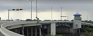
The Park Boulevard Bridge is a double-leaf bascule bridge that crosses the Narrows, part of the Gulf Intracoastal Waterway, connecting the barrier islands of Indian Shores and the mainland of Seminole, Florida. The bridge carries Park Boulevard, part of CR 694. The bridge was built in 1981. It had a toll, but ten years later, the tolls were removed.
The Indian Rocks Causeway is a twin-span double-leaf bascule bridge that crosses the Narrows, part of the Gulf Intracoastal Waterway, connecting the barrier islands of Indian Rocks Beach and the mainland of Largo, Florida. The bridge carries Walsingham Road, part of SR 688. The eastbound span of the Indian Rocks Causeway was built in 1958, replacing the original swing bridge built in 1916, and the westbound span was built in 1999.
The Sand Key Bridge is a girder bridge that crosses the Clearwater Pass, connecting Clearwater and Belleair Beach, Florida. The bridge carries Gulf of Mexico Boulevard, part of SR 699, and it was built in 1995, replacing the original bascule bridge built in the 1960s.

The Dunedin Causeway is a series of three bridges that cross the St. Joseph Sound, part of the Gulf Intracoastal Waterway, connecting the barrier islands of Honeymoon Island State Park and the mainland of Dunedin, Florida. The causeway carries CR 586 and it was built in 1963.