Haulover Canal

Last updated
Haulover Canal
Haulover Canal Bridge, FL, US.jpg
Haulover Canal Bridge
Haulover Canal.png
Location Brevard County, Florida
Country United States
Specifications
LocksNone
StatusOpen
Navigation authority U.S. Army Corps of Engineers
History
Date completed1887
Geography
Start point Mosquito Lagoon
End point Indian River

The Haulover Canal is a waterway north of Merritt Island, Florida, near the former site of Allenhurst, that connects Mosquito Lagoon with the Indian River, and is part of the Intracoastal Waterway.

Contents

In the early 1960s there were plans to relocate the canal further north, near the junction of US 1 and Courtenay Parkway, but by 1964 when the new Haulover Canal Bridge was constructed these plans had been shelved. [1]

Crossings

CrossingCarriesImageLocationCoordinates
Haulover Canal Bridge
(drawbridge)
Florida 3.svg SR 3
Courtenay Parkway
Allenhurst 28°44′11″N80°45′17″W / 28.73639°N 80.75472°W / 28.73639; -80.75472

Old Haulover Canal

Old Haulover Canal
Merritt Island Haulover canal sign01.jpg
Historic marker, with canal in background
USA Florida location map.svg
Red pog.svg
Usa edcp location map.svg
Red pog.svg
Location Brevard County, Florida
Nearest city Merritt Island
Coordinates 28°44′11″N80°45′17″W / 28.73639°N 80.75472°W / 28.73639; -80.75472 Coordinates: 28°44′11″N80°45′17″W / 28.73639°N 80.75472°W / 28.73639; -80.75472
NRHP reference No. 78000262
Added to NRHPDecember 19, 1978

The Old Haulover Canal is a historic location north of Merritt Island, Florida. On December 19, 1978, it was added to the United States National Register of Historic Places.

According to the state historical marker near the site:

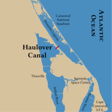
Native Americans, explorers and settlers hauled or carried canoes and small boats over this narrow strip of land between Mosquito Lagoon and the Indian River. Eventually it became known as the "haulover." Connecting both bodies of water had long challenged early settlers of this area. Spaniards visited as early as 1605 and slid boats over the ground covered with mulberry tree bark. Early settlers used rollers and skids to drag schooners across. Fort Ann was established nearby in 1837, during the 2nd Seminole War (1835–1842), to protect the haulover from Indians and carry military supplies from the lagoon to the river. In 1852, contractor G.E. Hawes dug the first canal using slave labor. It was 3 feet (0.91 m) deep, 14 feet (4.3 m) wide, and completed in time for the 3rd Seminole War (1856–1858). Steamboat and cargo ships used the passage until the railroad arrived in 1885. By 1887, the Florida Coast Line Canal and Transportation Company dug a new and deeper canal which you see now, a short distance from the original. The Intracoastal Waterway incorporated the Haulover Canal as a federal project in 1927 to be maintained by the U.S. Army Corps of Engineers. Since then the channel has been dug wider and deeper, and a basin added for launching boats. [2]

Related Research Articles

Merritt Island, Florida Census-designated place in Florida, United States

Merritt Island is a census-designated place (CDP) in Brevard County, Florida, United States, located on the eastern Floridian coast, along the Atlantic Ocean. The population was 34,518 at the 2020 census. It is part of the Palm Bay – Melbourne – Titusville, Florida Metropolitan Statistical Area. The name "Merritt Island" also refers to the extent of the peninsula, misnamed an "island".

St. Johns River The longest river in Florida, United States

The St. Johns River is the longest river in the U.S. state of Florida and its most significant one for commercial and recreational use. At 310 miles (500 km) long, it flows north and winds through or borders twelve counties. The drop in elevation from headwaters to mouth is less than 30 feet (9 m); like most Florida waterways, the St. Johns has a very low flow rate 0.3 mph (0.13 m/s) and is often described as "lazy".

Biscayne Bay Florida lagoon

Biscayne Bay is a lagoon, with characteristics of an estuary, located on the Atlantic coast of South Florida, United States. The northern end of the lagoon is surrounded by the densely developed heart of the Miami metropolitan area, while the southern end is largely undeveloped, with a large portion of the lagoon included in Biscayne National Park. Sources differ on the extent of the lagoon. The part of the lagoon that is traditionally called "Biscayne Bay" is approximately 35 miles (56 km) long and up to 8 miles (13 km) wide, with a surface area of 573 square kilometres (221 sq mi). Various definitions may include Dumfoundling Bay, Card Sound, and Barnes Sound in a larger "Biscayne Bay", which is 60 miles (97 km) long, with a surface area of about 703 square kilometres (271 sq mi).

Merritt Island National Wildlife Refuge

Merritt Island National Wildlife Refuge is a 140,000 acres (57,000 ha) U.S. National Wildlife Refuge (NWR) on the Atlantic coast of Florida's largest barrier island. NASA's Kennedy Space Center and visitor complex are also situated on the island and NASA can restrict access to the refuge based on its operational needs.

Mosquito Lagoon

Mosquito Lagoon is a body of water located on the east coast of Florida in Brevard and Volusia counties. It is part of the Indian River Lagoon system and the Atlantic Intracoastal Waterway. It extends from the Ponce de Leon Inlet to a point north of Cape Canaveral, and connects to the Indian River via the Haulover Canal. The Mosquito Lagoon Aquatic Preserve includes 4,740 acres (1,920 ha) in the northern end of the lagoon. The preserve originally extended to the southern end of the lagoon, but close to two-thirds of the preserve in the central and southern lagoon were transferred to the Federal government, and is now part of the Canaveral National Seashore. The cities of New Smyrna Beach and Edgewater, the Merritt Island National Wildlife Refuge and the Kennedy Space Center adjoin the lagoon.

Indian River Lagoon Three lagoons on the Atlantic Coast of Florida, United States

The Indian River Lagoon is a grouping of three lagoons: the Mosquito Lagoon, the Banana River, and the Indian River, on the Atlantic Coast of Florida; one of the most biodiverse estuaries in the Northern Hemisphere and is home to more than 4,300 species of plants and animals.

Indian River (Florida) Waterway in Florida, United States

The Indian River is a 121-mile (195 km) long brackish lagoon in Florida. It is part of the Indian River Lagoon system, which in turn forms part of the Atlantic Intracoastal Waterway. It was originally named Rio de Ais after the Ais Indian tribe, who lived along the east coast of Florida, but was later given its current name.

Banana River Lagoon in Florida, US

The Banana River is a 31-mile-long (50 km) lagoon that lies between Cape Canaveral and Merritt Island in Brevard County, Florida in the United States. It is part of the Indian River Lagoon system, and connects at its south end to the Indian River; it is the only part of the lagoon system not in the Intracoastal Waterway. It also has an outlet to the Atlantic Ocean via a lock into Port Canaveral. The lagoon includes salt marshes, mangrove swamps, seagrass beds, drift algae, oyster bars, tidal flats, and spoil islands, providing habitats for many marine species. These are brackish waters mixed of salt and fresh water; waist deep with a soft bottom sand/grass. Commercial and recreational activities in the lagoon generate more than US$ 800 million annually for the local economy.

Canaveral Barge Canal

The Canaveral Barge Canal is an active canal in Brevard County, Florida, cutting east-west across northern Merritt Island just south of Cape Canaveral. It connects the Atlantic Ocean and Port Canaveral with the Indian River and wider Indian River Lagoon, part of the Intracoastal Waterway. The canal consists of two segments separated by the Banana River.

Perdido Key, Florida Unincorporated community in Florida, United States

Perdido Key is an unincorporated community in Escambia County, Florida, United States, between Pensacola, Florida and Orange Beach, Alabama. "Perdido" means "lost" in the Spanish and Portuguese languages. The community is located on and named for Perdido Key, a barrier island in northwest Florida and southeast Alabama. The Florida district of the Gulf Islands National Seashore includes the east end of the island, as well as other Florida islands. No more than a few hundred yards wide in most places, Perdido Key stretches some 16 miles (26 km) from near Pensacola to Perdido Pass Bridge near Orange Beach.

Melbourne Causeway Bridge in Florida, United States of America

The Melbourne Causeway is located entirely within Brevard County, Florida in the United States. It is composed of three bridges and connects the municipalities of Melbourne and Indialantic across the Indian River Lagoon in Brevard County. The causeway is part of U.S. 192, whose eastern terminus is located approximately 2 miles (3.2 km) east of the bridge, at SR A1A. East of the bridge, the road is known locally as Fifth Avenue. On the western side, the road continues through downtown Melbourne as Strawbridge Avenue. Each July 4 the bridge is closed for a fireworks show.

Eau Gallie Causeway Bridge in Florida, United States of America

The Eau Gallie Causeway connects Eau Gallie, Florida, with SR A1A near Indian Harbour Beach, across the Indian River Lagoon. Located entirely within the Melbourne city limits, the causeway consists of a main bridge crossing over the Intracoastal Waterway and a relief bridge. The bridge is a key link in SR 518, Eau Gallie Boulevard, of which the causeway is a part.

Lake Worth Lagoon Lagoon in Florida, US

The Lake Worth Lagoon is a lagoon located in Palm Beach County, Florida. It runs parallel to the coast, and is separated from the Atlantic Ocean by barrier beaches, including Palm Beach Island. The lagoon is connected to the Atlantic Ocean by two permanent, man-made inlets.

Halifax River River in Florida, United States

The Halifax River is part of the Atlantic Intracoastal Waterway, located in northeast Volusia County, Florida. The waterway was originally known as the North Mosquito River, but was renamed after George Montagu-Dunk, 2nd Earl of Halifax, during the British occupation of Florida (1763–1784).

Canaveral National Seashore

The Canaveral National Seashore (CANA) is a National Seashore located between New Smyrna Beach and Titusville, Florida, in Volusia and Brevard Counties. The park, located on a barrier island, was created on January 3, 1975, by an act of Congress. The park is split between Brevard and Volusia counties, with 9 miles of the seashore in Brevard County, and 15 miles of the seashore in Volusia County. CANA consists of 24 miles of beaches, dunes, mangrove wetlands, and a large portion of the Mosquito Lagoon. The Canaveral National Seashore is also the longest expanse of undeveloped land along the East Coast of Florida. The Canaveral National Seashore is home to more than 1,000 plant species and 310 bird species. CANA occupies 57,662 acres (23,335 ha). There are 3 major beach sections in the seashore. The southern section is Playalinda Beach, the middle section is Klondike Beach, and the northern section is Apollo Beach.

NASA Causeway Bridge in Florida, United States of America

NASA Parkway, also known as NASA Causeway, is an east-west expressway in Brevard County, Florida, containing two causeways. The first causeway connects the Florida mainland to Merritt Island and later, over the private second causeway, connects Merritt Island to Cape Canaveral. As such, the NASA Parkway is the main route connecting points of interest in Titusville, Florida to the Kennedy Space Center on Merritt Island.

Brevard County, Florida has transportation available in the usual modes for a coastal county - highways, shipping, and airlines.

Douglas Dummett American politician

Douglas Dummett (1806–1873) was a plantation owner who served as a member of the Legislative Council of the Territory of Florida representing St. Johns County in 1843, and a member of the Florida House of Representatives representing Mosquito County in 1845. He was instrumental in developing the Indian River Citrus industry in Florida.

New River (Broward County, Florida) River in the United States of America

The New River is a tidal estuary in South Florida, United States. Despite its name, it is not a river, but a channel composed of many tributary canals, The channel is connected to the Everglades through a series of man-made canals. After passing through Fort Lauderdale, the channel connects to the Intracoastal Waterway and Atlantic Ocean at Port Everglades cut. The channel is entirely within Broward County and is composed from the junction of three main canals which originate in the Everglades, splitting off from the Miami Canal. They are the North New River Canal, which flows south from Lake Okeechobee along the east side of U.S. 27 and then east along the north side of State Road 84 / Interstate 595; the South New River Canal, which flows east from the Miami Canal along the north side of Griffin Road and the south side of Orange Drive; and a canal which flows east along the south side of Sunrise Boulevard.

References