Related Research Articles

Marion County is located in the northern portion of the U.S. state of Florida. As of the 2020 census, the population was 375,908. Its county seat is Ocala.

Alachua County is a county in the north central portion of the U.S. state of Florida. As of the 2020 census, the population was 278,468. The county seat is Gainesville, the home of the University of Florida since 1906, when the campus opened with 106 students.

Hawthorne is a city in Alachua County, Florida, United States, incorporated in 1881. Indigenous peoples of the Americas had been living in the area since around 100 CE; Hawthorne grew around their trading trails. Throughout its history, Hawthorne has been known for its agriculture, railroad, and rural lifestyle. Hawthorne's population was 1,478 at the 2020 census, with an area of 7.38 sq mi (19.1 km2).

The St. Johns River is the longest river in the U.S. state of Florida and it is the most significant one for commercial and recreational use. At 310 miles (500 km) long, it flows north and winds through or borders twelve counties. The drop in elevation from headwaters to mouth is less than 30 feet (9 m); like most Florida waterways, the St. Johns has a very slow flow speed of 0.3 mph (0.13 m/s), and is often described as "lazy".

Paynes Prairie Preserve State Park is a Florida State Park, encompassing a 21,000-acre (85 km2) savanna in Alachua County, Florida lying between Micanopy and Gainesville. It is also a U.S. National Natural Landmark. It is crossed by both I-75 and U.S. 441. It is in the center of the Paynes Prairie Basin. The basin's primary source of drainage is Alachua Sink. During occasional wet periods, the basin will become full. A notable period occurred from 1871 to 1891 when the Alachua Sink was temporarily blocked. During this period, shallow draft steamboats were a frequent sight on Alachua Lake in the center of the prairie. The region was also historically known as the Alachua Savannah. Its drainage has been modified by several canals. Since 1927, Camps Canal has linked the basin to the River Styx which leads to Orange Lake and eventually the Atlantic Ocean through the St. Johns River. That reduced the basins water intake by half. Additional changes to the prairie's environment have been detrimental to its hydrology. In 1970, the state of Florida acquired the land and has been in the process of restoring the environment to a more natural condition ever since.

North central Florida is a region of the U.S. state of Florida which comprises the north-central part of the state and encompasses the north Florida counties of Alachua, Marion, Putnam, Bradford, Columbia, Dixie, Gilchrist, Hamilton, Lafayette, Levy, Madison, Suwannee, Taylor, and Union. The region's largest city is Gainesville, home of the University of Florida and center of the Gainesville metropolitan area, which is the largest metro area of the region. As of 2020, the region had a population of 575,622 people.

Bivens Arm is a body of water in Gainesville, Florida. Located west of U.S. Route 441 and south of Archer Road, it is a part of Paynes Prairie. Bivens Arm is a small shallow lake covering approximately 189 acres (76 ha) in southwest Gainesville. Bivens Arm is a unique environment, which supports a wide diversity of plant and animal life in an urban setting. Tumblin Creek, which is fed by small springs and seeps, drains into Bivens Arm and is the primary source of drainage into the lake. Bivens Arm overflows onto Paynes Prairie and eventually discharges to the aquifer via Alachua Sink.

The 74-mile-long (119 km) Ocklawaha River flows north from central Florida until it joins the St. Johns River near Palatka. Its name is derived from ak-lowahe, Creek for "muddy".

Gainesville-Hawthorne State Trail is a paved rail trail in Florida.
The Cades Pond culture is defined as a Middle Woodland Southeast period archaeological culture in north-central Florida, dating from around 100 to 600 CE.
Cross Creek is an unincorporated community in Alachua County, Florida, United States. It is located on Cross Creek, a short stream connecting Orange and Lochloosa lakes.

Cross Creek is a natural waterway in Florida connecting Lochloosa Lake to Orange Lake, in southeastern Alachua County. It is 1.0 mile (1.6 km) long, and carries the outflow from Lochloosa Lake into Orange Lake. It is normally navigable by small boats, but has completely dried up in droughts. The creek has been designated an Outstanding Florida Water. County Road 325 crosses the creek. Cross Creek gives its name to the community of Cross Creek, which is famous as the home of Marjorie Kinnan Rawlings for the last 25 years of her life, and for being the subject of her memoir Cross Creek, which was made into a motion picture in 1983.

The Silver River is a short spring-fed river located east of Ocala in Marion County, Florida. Fed by Silver Springs, it connects the springs to the Ocklawaha River, passing through a pristine woodland environment. The river was probably named for its silvery appearance.

Newnans Lake is a lake located off State Road 20, east of Gainesville, Florida. Approximately 1.12 miles (2 km) wide, Newnans Lake is home to many forms of wildlife, and had been designated as a protected site by Alachua County.

Black Creek is a tributary of the St. Johns River in Clay County, Florida. It is formed by the confluence of North Fork Black Creek and South Fork Black Creek. North Fork Black Creek originates as an outflow from Kingsley Lake and flows north and then southeast, meeting South Fork Black Creek on the east side of MIddleburg. North Fork Black Creek has Yellow Water Creek as its main tributary. South Fork Black Creek originates in a chain of lakes about four miles south of Kingsley Lake, with Ates Creek, Bull Creek, and Greens Creek as its main tributaries. Both forks are fed by areas of wetlands and numerous small streams.

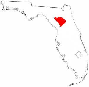
Orange Lake is in Alachua County, Florida, about 10 miles (16 km) south of Hawthorne. It has an area of about 12,550 acres (5,080 ha), and is part of the Orange Creek Basin, which is in turn part of the Oklawaha River watershed. Cross Creek flows into it from Lochloosa Lake, and Orange Creek drains it into the Rodman Reservoir. Orange Lake also receives water from Newnans Lake that has been diverted from its historic destination of Paynes Prairie. Orange Lake is noted for fishing, especially bass, with many fishing camps on its shores. The lake also has many natural floating islands, which have an "unusually high diversity", especially of amphibians.

Lochloosa Lake is a lake about 6,100 acres (2,500 ha) in area in Alachua County, Florida, about 4 miles (6.4 km) south of Hawthorne, and is up to 10 feet (3.0 m) deep. It is drained by Cross Creek into Orange Lake. It is largely surrounded by the Lochloosa Wildlife Management Area, and is a Fish Management Area. Lochloosa Creek is its largest tributary. The lake is noted for bass fishing.
The city of Gainesville, Florida, USA, was incorporated in 1869.
Etonia Creek, also known as Etoniah Creek, is a stream in Putnam and Clay counties in Florida. It is the major tributary of Rice Creek, which is a tributary of the St. Johns River. The upper or western part of the stream's basin, the Upper Etonia Creek Basin, contains about 100 lakes. Many of those lakes do not have outflowing streams. On leaving its upper basin, Etonia Creek flows eastward, and then southeastward to its juncture with Rice Creek.
References
- Citations
- ↑ "Orange Creek Basin". St. Johns River Water Management District. 2021. Archived from the original on September 3, 2021. Retrieved November 5, 2021.
- ↑ Clark et al., p. 56.
- ↑ Ritchie, Bruce (August 3, 1996). "Water district may buy muck farm". Star-Banner . Ocala, FL. p. 3B. Retrieved 2012-09-04.
- ↑ Faulkner 1973, p.24
- ↑ Faulkner 1973, p.54
- ↑ Chun, Diane (May 3, 1987). "Taking the waters once again at Orange Springs". The Gainesville Sun . Gainesville, FL. p. 10F. Retrieved 2012-09-04.
- ↑ Clark et al., pp. 56–57.
- ↑ "Lake Forest Creek Fact Sheet" (PDF). Alachua County Environmental Protection Department. Retrieved November 5, 2021.
- ↑ Andersen 2001, pp. 130–131.
- ↑ Andersen 2001, p. 2.
- ↑ "Fact Sheets". Alachua County Environmental Protection Department. Archived from the original on November 5, 2021. Retrieved November 5, 2021.
- ↑ "Lake Alice". UF Clean Water Campaign. 2016. Archived from the original on May 1, 2021. Retrieved November 5, 2021.
- ↑ McLin 1904, p.543
- ↑ Moorhead, Jim (May 17, 1962). "Marion-Putnam Officials Agree To Orange Creek Partial Survey". Star-Banner. Ocala, FL. p. 1. Retrieved 2012-09-04.
- ↑ "Creek Boundary Line To Be Set By Group". Star-Banner. Ocala, FL. April 23, 1969. p. 9B. Retrieved 2012-09-04.
- ↑ "Panel to study Orange Creek dam". The Gainesville Sun. Gainesville, FL. December 13, 1989. p. 2B. Retrieved 2012-09-04.
- ↑ "Editorial: Remove the dams". The Gainesville Sun. Gainesville, FL. November 24, 1990. p. 2G. Retrieved 2012-09-04.
- Bibliography
- Andersen, Lars (2001). Paynes Prairie: A History of the Great Savanna. Sarasota, Florida: Pineapple Press. ISBN 1-56164-225-8.
- Clark, William E.; Musgrove, Rufus H.; Menke, Clarence G.; Cagle, Joseph W. Jr. (1964). Water Resources of Alachua, Bradford, Clay and Union Counties, Florida. Report of Investigations. Vol. 35. Tallahassee, Florida: Florida Geological Survey. pp. 38–39, 43.
- Faulkner, Glen L., 1973. Geohydrology of the Cross-Florida Barge Canal Area with Special Reference to the Ocala Vicinity . Tallahassee, FL: U.S. Geological Survey Water Resources Investigations Report I-73. ISBN 978-1234202545.
- McLin, B.E., 1904. Florida: A Pamphlet Descriptive of Its History, Topography, Climate, Soil, Resources and Natural Advantages, In General and By Counties. Tallahassee, FL: Florida Department of Agriculture. ASIN B008TUWP38