Wacissa River

Last updated
The Wacissa River Wacissa River, Jefferson County (Florida,).jpg
The Wacissa River

The Wacissa River is a large, spring-fed stream located in south-central Jefferson County, Florida. Its headwaters are located about a mile south of the town of Wacissa, where the river emerges crystal clear from a group of large limestone springs. From its headsprings, the river flows approximately 12 miles (19 km) south through a broad cypress swamp before breaking into numerous braided channels which join the Aucilla River a few miles further south. The river is managed by the Florida Fish & Wildlife Conservation Commission as part of the Aucilla Wildlife Management Area, and has been declared an Outstanding Florida Waterway by the Florida Department of Environmental Protection.

Jefferson County, Florida County in Florida, United States

Jefferson County is a county located in the U.S. state of Florida. As of the 2010 census, the population was 14,761. Its county seat is Monticello.

Florida State of the United States of America

Florida is the southernmost contiguous state in the United States. The state is bordered to the west by the Gulf of Mexico, to the northwest by Alabama, to the north by Georgia, to the east by the Atlantic Ocean, and to the south by the Straits of Florida. Florida is the 22nd-most extensive, the 3rd-most populous, and the 8th-most densely populated of the U.S. states. Jacksonville is the most populous municipality in the state and the largest city by area in the contiguous United States. The Miami metropolitan area is Florida's most populous urban area. Tallahassee is the state's capital.

Wacissa, Florida Census-designated place in Florida, United States

Wacissa is a small unincorporated community and census-designated place (CDP) in Jefferson County, Florida, United States. As of the 2010 census the population was 386. It shares its name with the Wacissa River, the headwaters of which are about one mile to the south.

Contents

The Wacissa Springs

The springs that feed the Wacissa River emerge in a bottomland forest below the Cody Scarp, a relic marine terrace marked by a line of hills to the north. According to the Florida Bureau of Geology, [1] the group of springs

Cody Scarp

The Cody Scarp or Cody Escarpment is located in north and north central Florida United States. It is a relict scarp and ancient persistent topographical feature formed from an ancient early Pleistocene shorelines of ~1.8 million to 10,000 years BP during interglacial periods. The Cody Scarp has a slope of 5% to 12%.

consist of at least 12 known springs scattered along the upper 1.5 miles (2.4 km) of the Wacissa River. Land to the east and west of the river is flat and swampy and surface elevations are little more than 3 feet (0.91 m) above river level. The area immediately adjoining the river and springs is densely forested with cypress, oak, some pine, and generally moderate undergrowth. To the north, less than a mile from the head of the river, the land becomes hilly, rising in most parts more than 100 feet (30 m) above the lowland. The river is generally clear and cool, averaging 21 °C (70 °F) ... The distribution of springs in, as well as adjacent to, the Wacissa River and the heavy surface cover of aquatic plants makes difficult to impractical the reliable measurement [of the water flow] of individual springs ... The average flow [of the river] from August 1971 through September 1974 was 389 cubic feet per second.

Natural history

The flora is typical for a freshwater swamp in the deep southeast; pond cypress and bald cypress dominate the banks, followed by sweetbay, maple, sweet gum, hickories and oaks, as well as magnolias, holly, willow, and sabal palms. The water itself is heavily vegetated. The exotics, Water hyacinth and hydrilla, dominate the upper reaches of the river. The spring runs themselves are often home to pickerel weed, arrowhead, elodea and eel grass. Wild flowers are also present, including several varieties of water lilies. [2]

<i>Hydrilla</i> genus of aquatic plant

Hydrilla (Waterthyme) is a genus of aquatic plant, usually treated as containing just one species, Hydrilla verticillata, though some botanists divide it into several species. It is native to the cool and warm waters of the Old World in Asia, Africa and Australia, with a sparse, scattered distribution; in Australia from Northern Territory, Queensland, and New South Wales.

The Wacissa is well known for its large concentration of aquatic birds, including egrets, herons, ibis, osprey, wood storks, limpkins, anhingas, kingfishers, barred owls and bald eagles. Aquatic animals are also abundant, including alligators, river otters, turtles, water snakes, and crayfish. The main species of fish are bass, mullet, catfish, red-breasted sunfish, stumpknocker and gar, although the warmouth perch, speckled perch, flier bream, and shellcracker may also found in the Wacissa.

According to George L. Thurston III's 1976 report on the Wacissa for the Canoe Trail Atlas: [2]

Two centuries ago, open stands of virgin longleaf pine grew on the stony upland north of the extensive hardwood hammock at Nuttal Rise. West of the Wacissa, a wild swampy pineland was sprinkled with outcroppings of chert. The whole region of some 400 square miles (1,000 km2) swarmed with dear, bear, bobcat, wild turkey and bobwhites, as well as migratory birds and waterfowl by the billions. The limited use made of the river prior to the Civil War, for barging cotton to Newport from Jefferson County plantations, largely ended after the war and the area remained essential virgin. Late in the nineteenth century, the Wacissa area became well-known to ornithologists because of ivory-billed woodpeckers which were then fairly common there ...

Ivory-billed woodpecker species of bird

The ivory-billed woodpecker is one of the largest woodpeckers in the world, at roughly 20 inches (51 cm) long and 30 inches (76 cm) in wingspan. It is native to types of virgin forest ecosystems found in the Southeastern United States and Cuba. Habitat destruction and, to a lesser extent, hunting have decimated populations so thoroughly that the species is very probably extinct, though sporadic reports of sightings have continued into the 21st century. The ivory-billed woodpecker, dubbed the "holy grail bird" due to its appearance and behavior, is the subject of many rediscovery efforts and much speculation.

In 1930 the entire Wacissa watershed was clear-cut by timber companies which sold the pine and bald cypress lumber. The grades on which they built their tram roads still criss-cross the area, forming the basis for most of the dirt roads which now provide access to the river. Removal of the forest had remarkable results. When naturalist, Herbert Stoddard, Senior, visited the area in 1932 after the absence of some years, he reported the entire ecology of the lower river was "drastically changed." Instead of the shallow, clear stream he had once visited, he found it running high and dark in all seasons. Apple snails, which depend on clear, lime-laden water, survived only in the upper reaches of the river near the springs. Birds such as limpkin and egret which feed on the snails, had become as scarce as the snails.

Although much of the Wacissa forest is now some 85 years into recovery, logging activities are still common in the area. Large portions of the adjacent lands—though managed by the state of Florida—are owned by the St. Joe Company. However, the company has agreed not to cut trees in the immediate vicinity of the river. Today, the Wacissa is used almost exclusively for recreational purposes, including swimming, boating, fishing and birdwatching.

The St. Joe Company, until 1966 the St. Joe Paper Company, is a land development company headquartered in Watersound, Florida. The company had been headquartered in Jacksonville, Florida, United States, and is Florida's second largest private landowner, owning about 567,000 acres in the state as of November 2012.

Related Research Articles

Corkscrew Swamp Sanctuary nature reserve in southwest Florida

Corkscrew Swamp Sanctuary is a National Audubon Society sanctuary located in southwest Florida, north of Naples, Florida and east of Bonita Springs, in the United States. The sanctuary was established to protect one of the largest remaining stands of bald cypress and pond cypress in North America from extensive logging that was ongoing throughout the 1940s and 1950s.

Goose Creek State Park

Goose Creek State Park is a North Carolina state park near Washington, Beaufort County, North Carolina in the United States. It covers 1,672 acres (6.77 km2) just off of Pamlico Sound, in North Carolina's Coastal Plain. Goose Creek State Park is home to a wide variety of wildlife that make their homes in the extensive salt water marshes, inlets and creeks on the northern side of the sound. Goose Creek State Park is open for year-round recreation, east of Washington, two miles (3 km) south of U.S. Route 264 on Camp Leach Road.

Hillsborough River (Florida) River in the United States of America

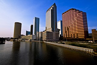
The Hillsborough River is a river located in the state of Florida in the United States. It arises in the Green Swamp near the juncture of Hillsborough, Pasco and Polk counties, and flows 60 miles (97 km) through Pasco and Hillsborough Counties to an outlet in the city of Tampa on Tampa Bay. It includes 4 nature trails extending for over seven miles, making it perfect for hikers. The name Hillsborough River first appeared on a British map in 1769. At the time, the Earl of Hillsborough was the British Secretary of State for the Colonies, and thus controlled the pensions of the surveyors working in the American colonies, which included East Florida.

Ichetucknee River River in Florida, United States

The Ichetucknee River is a spring-fed, pristine river in North Central Florida. The entire 6 miles (9.7 km) of the river average 20 feet (6.1 m) wide, 5 feet (1.5 m) deep and most of the 6 miles lie within the boundaries of the Ichetucknee Springs State Park while the rest is to the south of US Highway 27. Three Rivers Estates Property Owners (TREPO) is the property owner association that manages the area along the private side of the river as it travels and flows into the Santa Fe River.

Myakka River State Park

Myakka River State Park is a Florida State Park, that is located nine miles (14 km) east of Interstate 75 in Sarasota County and a portion of southeastern Manatee County. The state park consists of 37,000 acres (150 km2), making it one of the state's largest parks. It is also one of the oldest parks in the state. It was delineated in the 1930s by the Civilian Conservation Corps. A small portion of the park was the gift of the family of Bertha Palmer to the state. The park is named after the Myakka River.

De Leon Springs State Park

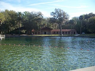
De Leon Springs State Park is a Florida State Park in Volusia County, Florida. It is located in DeLeon Springs, off CR 3.

Picayune Strand State Forest

Picayune Strand State Forest is one of 37 state forests in Florida managed by the Florida Forest Service. The 78,000-acre forest consists primarily of cypress swamps, wet pine flatwoods and wet prairies. It also features a grid of closed roads over part of it, left over from its previous land development schemes.

Lower Suwannee National Wildlife Refuge

The Lower Suwannee National Wildlife Refuge (LSNWR) is part of the United States National Wildlife Refuge System. It is located in southeastern Dixie and northwestern Levy counties on the western coast of Florida, approximately fifty miles southwest of the city of Gainesville.

Aucilla River River in Florida and Georgia, United States

The Aucilla River rises in Brooks County, Georgia, USA, close to Thomasville, and passes through the Big Bend region of Florida, emptying into the Gulf of Mexico at Apalachee Bay. Some early maps have it called the Ocilla River. The river is 89 miles (143 km) long and has a drainage basin of 747 square miles (1,930 km2). Tributaries include the Little Aucilla and Wacissa Rivers. In Florida, the Aucilla River forms the eastern border of Jefferson County, separating it from Madison County on the northern part, and from Taylor County to the south.

Florida Trail

The Florida Trail is one of eleven National Scenic Trails in the United States. It currently runs 1,000 miles (1,600 km), with 300 miles (480 km) planned, from Big Cypress National Preserve to Fort Pickens at Gulf Islands National Seashore, Pensacola Beach. Also known as the Florida National Scenic Trail, the Florida Trail provides permanent non-motorized recreation opportunity for hiking and other compatible activities and is within an hour of most Floridians. The Florida National Scenic Trail is designated as a National Scenic Trail by the National Trails System Act of 1968.

Blackwater River (Florida) River in Florida, United States

The Blackwater River of Florida is a 56.6-mile-long (91.1 km) river rising in southern Alabama and flowing through the Florida Panhandle to the Gulf of Mexico. The river enters Florida in Okaloosa County and flows through Santa Rosa County to Blackwater Bay, an arm of Pensacola Bay. The river passes through Blackwater River State Forest and Blackwater River State Park. Milton, the county seat of Santa Rosa County, is located on the river.

Lake George State Forest

The Lake George State Forest is a designated protected area and state forest in the U.S. state of Florida. The 21,176-acre (8,570 ha) forest is located in northwestern Volusia County, Florida, near Lake George and the communities of Pierson, Barberville, and Volusia. It is overseen by the Florida Forest Service within the Florida Department of Agriculture and Consumer Services.

Pocomoke State Forest is a state forest of Maryland that lies on both banks of the Pocomoke River in Worcester County. The portion north of the Pocomoke lies between Dividing and Nassawango Creeks. The Pocomoke River Wildlife Management Area borders the southern portion of the forest.

Geography and ecology of the Everglades

The geography and ecology of the Everglades involve the complex elements affecting the natural environment throughout the southern region of the U.S. state of Florida. Before drainage, the Everglades were an interwoven mesh of marshes and prairies covering 4,000 square miles (10,000 km2). The Everglades is simultaneously a vast watershed that has historically extended from Lake Okeechobee 100 miles (160 km) south to Florida Bay, and many interconnected ecosystems within a geographic boundary. It is such a unique meeting of water, land, and climate that the use of either singular or plural to refer to the Everglades is appropriate. When Marjory Stoneman Douglas wrote her definitive description of the region in 1947, she used the metaphor "River of Grass" to explain the blending of water and plant life.

The Dragon Run watershed in the U.S. state of Virginia encompasses 140 square miles (360 km2) and is home to many flora and fauna species. The brackish water stream, labeled on topographic maps as Dragon Swamp, is fed by underground springs, surface runoff, and numerous feeding swamps. In a study of 232 rivers and streams in the Chesapeake Bay, the Nature Conservancy and the Chesapeake Bay Foundation found the Dragon Run to rank second in terms of ecological significance. Efforts are being made to preserve the Dragon Run, including Governor Tim Kaine’s large purchase of land in order to maintain and protect the watershed’s original state.

Mississippi lowland forests

The Mississippi lowland forests are a temperate broadleaf and mixed forest ecoregion in the eastern United States, covering an area of 112,300 km2 (43,400 sq mi).

Edward Ball Wakulla Springs State Park

Edward Ball Wakulla Springs State Park is a Florida State Park in Wakulla County, Florida, United States. This 6,000 acre (24 km2) wildlife sanctuary, located south of Tallahassee, is listed on the National Register of Historic Places, and designated a National Natural Landmark. It has three nature trail systems which lead the visitor through pine forests, bald cypress wetlands and hardwood hammock. Hikers, bicyclists and horse riders are welcome. The wildlife found in the forest includes white-tailed deer, wild turkey, and many other bird species, while American alligators, bass, gar, various snakes, and West Indian manatee populate the springs, swamps, and river.

Aucilla Wildlife Management Area conserves 50,471 acres of hydric hammock, mesic flatwoods, upland forest, and spring-run river twelve miles southeast of Tallahassee in Jefferson County, Florida.

References

  1. Rosenau, et al., pp. 190 - 195
  2. 1 2 Thurston

Coordinates: 30°22′29″N83°48′44″W / 30.3746767°N 83.8122081°W / 30.3746767; -83.8122081