Jefferson County, Florida

Last updated

Jefferson County
MonticelloFL-CoCourtHs-2009.JPG
Jefferson County Courthouse in Monticello
Seal of Jefferson County, Florida.png
Map of Florida highlighting Jefferson County.svg
Location within the U.S. state of Florida
Florida in United States.svg
Florida's location within the U.S.
Coordinates: 30°25′N83°54′W / 30.42°N 83.9°W / 30.42; -83.9
CountryFlag of the United States.svg United States
StateFlag of Florida.svg  Florida
FoundedJanuary 20, 1827
Named for Thomas Jefferson
Seat Monticello
Largest cityMonticello
Area
  Total
637 sq mi (1,650 km2)
  Land598 sq mi (1,550 km2)
  Water38 sq mi (100 km2)  6.0%
Population
 (2020)
  Total
14,510 Decrease2.svg
  Density23/sq mi (9/km2)
Time zone UTC−5 (Eastern)
  Summer (DST) UTC−4 (EDT)
Congressional district 2nd
Website www.jeffersoncountyfl.gov

Jefferson County is a county located in the Big Bend region in the northern part of the U.S. state of Florida. As of the 2020 census, the population was 14,510. [1] Its county seat is Monticello. [2]

Contents

Jefferson County is part of the Tallahassee, FL Metropolitan Statistical Area but is the 3rd most rural county in Florida. [3] There are no traffic signals within the entire county. [4]

History

In the mid to late 18th century, a group of Native Americans from Chiaha chiefdom settled in what is now Jefferson County. This group would eventually become an element of the Mikasuki speaking Seminole. [5]

Jefferson County was created in 1827. It was named for Thomas Jefferson, third president of the United States, who had died the year before the county's establishment. [6]

Forts of Jefferson County

American Civil War and Emancipation

In the two decades leading up to the American Civil War, cotton was the primary source of income in the county, with about seventeen percent of all Florida cotton being grown in Jefferson County. It was also the county with the second most large plantations (fifty-five plantations with thirty or more slaves) in Florida, behind only Leon County. In 1860, the county had a population of 9,876 with sixty-four percent being black. Following emancipation, the black population of Jefferson County continued to grow. By 1870 the population had risen to 13,968 with seventy-two percent black. To serve the relatively large black population in the county, the Freedmen's Bureau established an office in Monticello sometime around early 1866. [8]

Geography

Entering Jefferson County on US 19 from Thomas County, Georgia Fla-Ga state line US 19 south01.jpg
Entering Jefferson County on US 19 from Thomas County, Georgia

According to the U.S. Census Bureau, the county has a total area of 637 square miles (1,650 km2), of which 598 square miles (1,550 km2) is land and 38 square miles (98 km2) (6.0%) is water. [9]

Jefferson County is the only county in Florida which borders both the state of Georgia and the Gulf of Mexico.

Adjacent counties

National protected area

Water Bodies

Demographics

Historical population
CensusPop.Note
1830 3,312
1840 5,71372.5%
1850 7,71835.1%
1860 9,87628.0%
1870 13,39835.7%
1880 16,06519.9%
1890 15,757−1.9%
1900 16,1952.8%
1910 17,2106.3%
1920 14,502−15.7%
1930 13,408−7.5%
1940 12,032−10.3%
1950 10,413−13.5%
1960 9,543−8.4%
1970 8,778−8.0%
1980 10,70321.9%
1990 11,2965.5%
2000 12,90214.2%
2010 14,76114.4%
2020 14,510−1.7%
2023 (est.)15,450 [10] 6.5%
U.S. Decennial Census [11]
1790-1960 [12] 1900-1990 [13]
1990-2000 [14] 2010-2019 [15]
Jefferson County, Florida – Racial and ethnic composition
Note: the US Census treats Hispanic/Latino as an ethnic category. This table excludes Latinos from the racial categories and assigns them to a separate category. Hispanics/Latinos may be of any race.
Race / Ethnicity (NH = Non-Hispanic)Pop 2010 [16] Pop 2020 [17] % 2010% 2020
White alone (NH)8,6688,72058.72%60.10%
Black or African American alone (NH)5,2934,60035.86%31.7%
Native American or Alaska Native alone (NH)33360.22%0.25%
Asian alone (NH)49340.33%0.23%
Pacific Islander alone (NH)430.03%0.02%
Other race alone (NH)9540.06%0.37%
Mixed race or Multiracial (NH)1594051.08%2.79%
Hispanic or Latino (any Race)5466583.70%4.53%
Total14,76114,510100.00%100.00%

2020 census

As of the 2020 United States census, there were 14,510 people, 5,770 households, and 3,761 families residing in the county.

2010 census

As of the census [18] of 2010, there were 14,761 people, 5,646 households, and 3,798 families residing in the county. The population density was 25 people per square mile (9.7 people/km2). There were 5,251 housing units at an average density of 9 per square mile (3.5/km2). The racial makeup of the county was 60.4% White, 36.2% Black or African American, 0.30% Native American, 0.40% Asian, 0.0% Pacific Islander, 1.50% from other races, and 1.30% from two or more races. 3.70% of the population were Hispanic or Latino of any race.

There were 5,646 households, out of which 26.9% had individuals under the age of 18 living with them, 47.30% were married couples living together, 15.10% had a female householder with no husband present, and 32.70% were non-families. 28.1% of all households were made up of individuals, and 10.6% had someone living alone who was 65 years of age or older. The average household size was 2.38 and the average family size was 2.89.

In the county, the population was spread out, with 18.6% under the age of 18, 8.20% from 18 to 24, 25.0% from 25 to 44, 32.30% from 45 to 64, and 16.5% who were 65 years of age or older. The median age was 44.1 years. For every 100 females, there were 109.6 males. For every 100 females age 18 and over, there were 110.00 males age 18 and over.

The following income information is from the 2000 census. The median income for a household in the county was $32,998, and the median income for a family was $40,407. Males had a median income of $26,271 versus $25,748 for females. The per capita income for the county was $17,006. About 13.30% of families and 17.10% of the population were below the poverty line, including 21.70% of those under age 18 and 17.00% of those age 65 or over.

Government and politics

Jefferson County, like most counties in the Florida Panhandle, historically voted for Democratic candidates. However, while most counties in the Panhandle started reliably voting for Republican candidates, Jefferson County has divided its support among Democratic and Republican candidates. From 2000 to 2012, while Democratic candidates for President won the county, the margin dwindled over time; in 2016, the county voted for Donald Trump, the first time that it had voted for a Republican presidential candidate since 1988. In 2020, Trump expanded his margin of victory. Jefferson County consistently backed Democratic candidates in statewide races, but in 2018, Ron DeSantis became the first Republican gubernatorial nominee to win Jefferson County since 1884.

Jefferson County Officials
PositionIncumbentNext election
District 1 CommissionerChristopher Tuten2024
District 2 CommissionerGene Hall2026
District 3 CommissionerJ. T. Surles2024
District 4 CommissionerAustin Hosford2026
District 5 CommissionerBenjamin "Ben" White2024
Clerk of Courts and ComptrollerKirk Reams2024
SheriffMac McNeill2024
Property AppraiserAngela C. Gray2024
Tax CollectorLois Howell Hunter2024
Supervisor of ElectionsMichelle Milligan2024
United States presidential election results for Jefferson County, Florida [19]
Year Republican Democratic Third party(ies)
No.%No.%No.%
2024 5,01158.73%3,42940.19%921.08%
2020 4,47952.89%3,89746.02%921.09%
2016 3,93051.11%3,54146.05%2182.84%
2012 3,80848.70%3,94550.45%670.86%
2008 3,79747.59%4,08851.24%931.17%
2004 3,29844.10%4,13555.30%450.60%
2000 2,47843.91%3,04153.89%1242.20%
1996 1,85138.49%2,54452.90%4148.61%
1992 1,50632.19%2,27148.55%90119.26%
1988 2,32652.89%2,05546.73%170.39%
1984 2,24452.16%2,05747.81%10.02%
1980 1,62339.19%2,36757.16%1513.65%
1976 1,36136.30%2,31061.62%782.08%
1972 2,10866.04%1,04932.86%351.10%
1968 45914.84%1,06634.48%1,56750.68%
1964 1,68452.82%1,50447.18%00.00%
1960 60034.70%1,12965.30%00.00%
1956 54031.02%1,20168.98%00.00%
1952 66536.22%1,17163.78%00.00%
1948 15311.56%70052.91%47035.53%
1944 18814.93%1,07185.07%00.00%
1940 21513.21%1,41286.79%00.00%
1936 1279.27%1,24390.73%00.00%
1932 815.40%1,41894.60%00.00%
1928 23520.22%91979.09%80.69%
1924 669.69%56683.11%497.20%
1920 23922.85%75472.08%535.07%
1916 10413.70%64685.11%91.19%
1912 478.45%45982.55%508.99%
1908 14918.81%56571.34%789.85%
1904 12320.20%47177.34%152.46%
1900 14316.55%71182.29%101.16%
1896 24211.07%1,90987.29%361.65%
1892 00.00%1,533100.00%00.00%
1884 1,52567.21%74432.79%00.00%

Education

Former Jefferson County Middle / High School Jefferson Cty High School Monticello01.jpg
Former Jefferson County Middle / High School

Jefferson County Schools is the school district of the county. [20] It operates public schools, including Jefferson County Middle / High School. Private Aucilla Christian Academy enrolls about half as many students as the Jefferson County public schools.

Library

Jefferson County's library is the R.J. Bailar Public Library, a member of the Wilderness Coast Public Libraries Cooperative. It is located in the building that once housed the old Jefferson High School library. [21]

Transportation

Railroads

The sole existing railroad line is a CSX line once owned by the Seaboard Air Line Railroad that was used by Amtrak's Sunset Limited until 2005, when the service was truncated to New Orleans by Hurricane Katrina. No Amtrak trains stopped anywhere in Jefferson County.

Major highways

Communities

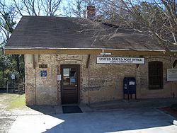
Old Lloyd Railroad Depot, now the area's post office Lloyd Railroad Depot02.jpg
Old Lloyd Railroad Depot, now the area's post office

City

Census-designated places

Other unincorporated communities

See also

Related Research Articles

<span class="mw-page-title-main">Columbia County, Florida</span> County in Florida, United States

Columbia County is a county located in the north central portion of the U.S. state of Florida. As of the 2020 census, the population was 69,698, up from 67,531 at the 2010 census. Its county seat is Lake City.

<span class="mw-page-title-main">Gadsden County, Florida</span> County in Florida, United States

Gadsden County is a county located in the panhandle of the U.S. state of Florida. As of the 2020 census, the population was 43,826. Its county seat is Quincy. Gadsden County is included in the Tallahassee Metropolitan Statistical Area. Gadsden County is the only majority African-American county in Florida.

<span class="mw-page-title-main">Hamilton County, Florida</span> County in Florida, United States

Hamilton County is a county located in the north central portion of the U.S. state of Florida. As of the 2020 census, the population was 14,004, down from 14,799 at the 2010 census. Its county seat is Jasper.

<span class="mw-page-title-main">Lafayette County, Florida</span> County in Florida, United States

Lafayette County is a county located in the north central portion of the state of Florida. As of the 2020 census, the population was 8,226, making it the second-least populous county in Florida. The county seat is Mayo. Lafayette County is a prohibition or partially dry county, allowing retail sales of beer.

<span class="mw-page-title-main">Madison County, Florida</span> County in Florida, United States

Madison County is a county located in the north central portion of the state of Florida, and borders the state of Georgia to the north. As of the 2020 census, the population was 17,968. Its county seat is also called Madison.

<span class="mw-page-title-main">Suwannee County, Florida</span> County in Florida, United States

Suwannee County is a county located in the north central portion of the state of Florida. As of the 2020 census, the population was 43,474, up from 41,551 in 2010. Its county seat is Live Oak. Suwannee County was a dry county until August 2011, when the sale of alcoholic beverages became legal in the county.

<span class="mw-page-title-main">Pike County, Alabama</span> County in Alabama, United States

Pike County is a county located in the U.S. state of Alabama. As of the 2020 census the population was 33,009. Its county seat is Troy. Its name is in honor of General Zebulon Pike, of New Jersey, who led an expedition to southern Colorado and encountered Pikes Peak in 1806.

<span class="mw-page-title-main">Madison County, Texas</span> County in Texas, United States

Madison County is a county located in the U.S. state of Texas. As of the 2020 census, its population was 13,455. Its seat is Madisonville. The county was created in 1853 and organized the next year. It is named for James Madison, the fourth President of the United States. In 1852, Hillary Mercer Crabb was elected to serve the unexpired term of State Representative F. L. Hatch. Among Crabb's accomplishments as a legislator was the introduction of a bill to create Madison County.

<span class="mw-page-title-main">Madison County, Ohio</span> County in Ohio, United States

Madison County is a county located in the central portion of the U.S. state of Ohio. As of the 2020 census, the population was 43,824. Its county seat is London. The county is named for James Madison, President of the United States and was established on March 1, 1810. Madison County is part of the Columbus, OH Metropolitan Statistical Area.

<span class="mw-page-title-main">Henry County, Iowa</span> County in Iowa, United States

Henry County is a county located in the U.S. state of Iowa. As of the 2020 census, the population was 20,482. The county seat is Mount Pleasant. The county was named for General Henry Dodge, governor of Wisconsin Territory.

<span class="mw-page-title-main">Monticello, Florida</span> City in Florida, United States

Monticello is the only city and the county seat of Jefferson County, Florida, United States. The city is named after Monticello, the estate of the county's namesake, Thomas Jefferson, on which the Jefferson County Courthouse was modeled. The population was 2,589 at the 2020 census. It is part of the Tallahassee, Florida Metropolitan Statistical Area.

<span class="mw-page-title-main">Greenville, Florida</span> Town in the state of Florida, United States

Greenville is a town in Madison County, Florida, United States. The population was 746 at the 2020 census, down from 843 at the 2010 census.

<span class="mw-page-title-main">Lee, Florida</span> Town in the state of Florida, United States

Lee is a town in Madison County, Florida, United States. The Town of Lee is part of the Florida Panhandle in North Florida. The population was 375 at the 2020 census.

<span class="mw-page-title-main">Madison, Florida</span> City in Florida, United States

Madison is a city in and the county seat of Madison County, on the central northern border of Florida, United States. The population was 2,912 at the 2020 census.

<span class="mw-page-title-main">Hilliard, Florida</span> Town in the state of Florida, United States

Hilliard is a town in Nassau County, Florida, United States; northwest of Jacksonville. It is part of the Jacksonville, Florida Metropolitan Statistical Area. As of the 2020 census, the population was 2,967, down from 3,086 at the 2010 census.

<span class="mw-page-title-main">Fort Davis, Texas</span> Town in Jeff Davis County

Fort Davis is an unincorporated community and census-designated place (CDP) in Jeff Davis County, Texas, United States. The population was 1,201 at the 2010 census, up from 1,050 at the 2000 census. It is the county seat of Jeff Davis County.

<span class="mw-page-title-main">Fort Atkinson, Wisconsin</span> City in Wisconsin, United States

Fort Atkinson is a city in Jefferson County, Wisconsin, United States. It is on the Rock River, a few miles upstream from Lake Koshkonong. The population was 12,579 at the 2020 census. Fort Atkinson is the largest city located entirely in Jefferson County, as Watertown is split between Jefferson and Dodge counties. Fort Atkinson is a principal city of the Fort Atkinson-Watertown micropolitan statistical area which is in turn a sub-market of the larger Milwaukee-Waukesha-Racine CSA.

<span class="mw-page-title-main">Wacissa, Florida</span> Census-designated place in Florida, United States

Wacissa is a small unincorporated community and census-designated place (CDP) in Jefferson County, Florida, United States. As of the 2020 census, the population was 362, down from 386 at the 2010 census. It is part of the Tallahassee, Florida Metropolitan Statistical Area. It shares its name with the Wacissa River, the headwaters of which are about one mile to the south.

Lamont is an unincorporated community and census-designated place (CDP) in Jefferson County, Florida, United States. As of the 2020 census,the population was 170, down from 178 at the 2010 census. It is part of the Tallahassee, Florida Metropolitan Statistical Area.

Aucilla is an unincorporated community and census-designated place (CDP) in Jefferson County, Florida, United States, located near the intersection of county roads 158 and 257. As of the 2020 census, the population was 103, up from 100 at the 2010 census. It is part of the Tallahassee, Florida Metropolitan Statistical Area.

References

  1. "Census - Geography Profile: Jefferson County, Florida". United States Census Bureau . Retrieved December 25, 2022.
  2. "Find a County". National Association of Counties. Archived from the original on May 31, 2011. Retrieved June 7, 2011.
  3. "Most rural counties in Florida". Stacker. Stacker Media. Retrieved February 3, 2022.
  4. "Visit historic Jefferson County". Visit historic Jefferson County. Jefferson County Tourism Development Council. Retrieved February 3, 2022.
  5. Mahon, John K. (2017). History of the Second Seminole War, 1835-1842 (ePub ed.). Gainesville, FL: LibraryPress@UF. p. 5. ISBN   978-1-947372-26-9.
  6. Publications of the Florida Historical Society. Florida Historical Society. 1908. p. 32.
  7. "IRC Library:Fort Roger Jones". Archived from the original on March 16, 2013. Retrieved August 1, 2008.
  8. Stone, Alva T. (Summer 2017). "Diary of a Freedmen's Bureau Agent: Alfred B. Grunwell in Jefferson County, Florida". The Florida Historical Quarterly. 96 (1): 1–5. JSTOR   44955725 . Retrieved October 21, 2024.
  9. "US Gazetteer files: 2010, 2000, and 1990". United States Census Bureau. February 12, 2011. Retrieved April 23, 2011.
  10. "Annual Estimates of the Resident Population for Counties: April 1, 2020 to July 1, 2023". United States Census Bureau. Retrieved March 31, 2024.
  11. "U.S. Decennial Census". United States Census Bureau. Retrieved June 14, 2014.
  12. "Historical Census Browser". University of Virginia Library. Retrieved June 14, 2014.
  13. "Population of Counties by Decennial Census: 1900 to 1990". United States Census Bureau. Retrieved June 14, 2014.
  14. "Census 2000 PHC-T-4. Ranking Tables for Counties: 1990 and 2000" (PDF). United States Census Bureau. Retrieved June 14, 2014.
  15. "State & County QuickFacts". United States Census Bureau. Retrieved February 14, 2014.[ permanent dead link ]
  16. "P2 Hispanic or Latino, and Not Hispanic or Latino by Race – 2010: DEC Redistricting Data (PL 94-171) – Jefferson County, Florida". United States Census Bureau .
  17. "P2 Hispanic or Latino, and Not Hispanic or Latino by Race – 2020: DEC Redistricting Data (PL 94-171) – Jefferson County, Florida". United States Census Bureau .
  18. "U.S. Census website". United States Census Bureau . Retrieved May 14, 2011.
  19. Leip, David. "Dave Leip's Atlas of U.S. Presidential Elections". uselectionatlas.org. Retrieved November 10, 2024.
  20. "2020 CENSUS - SCHOOL DISTRICT REFERENCE MAP: Jefferson County, FL" (PDF). U.S. Census Bureau . Retrieved July 31, 2022. - Text list
  21. "Jefferson County RJ Bailar Public Library". jcpl.wildernesscoast.org. JEFFERSON COUNTY R.J. BAILAR PUBLIC LIBRARY. Retrieved February 22, 2024.


30°25′N83°54′W / 30.42°N 83.90°W / 30.42; -83.90