St. Johns County, Florida

Last updated

St. Johns County
St. Augustine, FL, Courthouse, St. Johns County, 08-09-2010 (3).JPG
St. Johns County Courthouse
Flag of St. Johns County, Florida.png
St Johns County Fl Seal.png
Map of Florida highlighting St. Johns County.svg
Location within the U.S. state of Florida
Florida in United States.svg
Florida's location within the U.S.
Coordinates: 29°55′N81°25′W / 29.91°N 81.41°W / 29.91; -81.41
CountryFlag of the United States.svg United States
StateFlag of Florida.svg  Florida
FoundedJuly 21, 1821
Named for San Juan del Puerto
Seat St. Augustine
Largest community St. Johns
Area
  Total822 sq mi (2,130 km2)
  Land601 sq mi (1,560 km2)
  Water221 sq mi (570 km2)  26.9%
Population
 (2020)
  Total273,425 Increase2.svg
  Density455/sq mi (176/km2)
Time zone UTC−5 (Eastern)
  Summer (DST) UTC−4 (EDT)
Congressional districts 5th, 6th
Website www.sjcfl.us

St. Johns County is a county in the northeastern part of the U.S. state of Florida. As of the 2020 United States census, its population was 273,425. [1] The county seat and most populous incorporated city is St. Augustine, although the nearby community, St. Johns, has a higher population. [2] St. Johns County is part of the Jacksonville metropolitan area.

Contents

The county was established in 1821. It is one of the two original counties established after Florida was ceded to the United States, at the start of the Florida Territorial period, and corresponded roughly to the former colonial province of East Florida. It was named for the St. Johns River, which runs along its western border.

Today, St. Johns County primarily comprises residential bedroom communities for those who commute to Jacksonville. Tourism, primarily associated with St. Augustine and the many golf courses in the area, is the chief economic industry.

History

St. Johns County's history begins in 1821, when Colonel Robert Butler received Spanish East Florida from Captain-General Colonel José M. Coppinger. Butler represented Major General Andrew Jackson, federal military commissioner for the Florida provinces (las Floridas) with the powers of governor, exercising the powers of the Captain General and the Intendants of the Island of Cuba and the governors of the said provinces, respectively, who ordained that all the country east of the river Suwannee [3] should be designated the County of St. Johns.

St. Johns was established, along with Escambia County (in the former West Florida province), on July 21, 1821, 11 days after Butler received Florida for the United States, and five days after the city of St. Augustine was incorporated.

The name Saint John's was derived from the Spanish mission (c. 1580) San Juan del Puerto ("Saint John of the Harbor"). The U.S. Department of the Interior dropped the apostrophe in 1932 because an apostrophe implied ownership.

It was a huge county, encompassing most of peninsular Florida, more than 39,000 square miles; it was 475 miles long by 165 miles wide. Much of the land was uninhabited. Saint Augustine (1565) was the oldest permanent European settlement, and there were Native Americans in the county as well. [3]

Coat of arms

As described in Certification of the Coat of Arms: [4]

In a field of green an Agnus Dei of silver, suspended on the dexter [*left side of the drawing] side of the Agnus Dei is a silver banner with red cross (as a direct allusion and symbol of the name of the County). On a heraldic chief of red is a gold castle with towers, with masonry joints in black, and with the windows and doors in red (in recognition of the fortress that was constructed in the military garrison of St. Augustine which is a part of the County).

An overall border is composed of eight parts; alternating, a red quadrilateral, with a gold castle and quadrilateral of silver with a purple lion rampant (that is to say, alternating the simplified Arms of Castille and Leon).

Given for a crest is a mural crown of a province. This is a circle of gold walls with in reality twelve gold towers with all the masonry joints in black. Only seven of the towers are visible in the drawing.
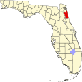
Geography

According to the U.S. Census Bureau, the county has an area of 822 square miles (2,130 km2), of which 601 square miles (1,560 km2) is land and 221 square miles (570 km2) (26.9%) is water. [5]

Adjacent counties

National protected areas

Demographics

Historical population
CensusPop.Note
1830 2,583
1840 2,6944.3%
1850 2,525−6.3%
1860 3,03820.3%
1870 2,618−13.8%
1880 4,53573.2%
1890 8,71292.1%
1900 9,1655.2%
1910 13,20844.1%
1920 13,061−1.1%
1930 18,67643.0%
1940 20,0127.2%
1950 24,99824.9%
1960 30,03420.1%
1970 30,7272.3%
1980 51,30367.0%
1990 83,82963.4%
2000 123,13546.9%
2010 190,03954.3%
2020 273,42543.9%
2023 (est.)320,110 [6] 17.1%
U.S. Decennial Census [7]
1790-1960 [8] 1900-1990 [9]
1990-2000 [10] 2010, 2020 [1]
St. Johns County racial composition as of 2020
(NH = Non-Hispanic) [lower-alpha 1]
RacePop 2010 [13] Pop 2020 [14] % 2010% 2020
White (NH)162,194214,42885.35%78.42%
Black or African American (NH)10,38812,9405.47%4.73%
Native American or Alaska Native (NH)4575440.24%0.2%
Asian (NH)3,8549,7642.03%3.57%
Pacific Islander (NH)1401510.07%0.06%
Some Other Race (NH)2901,2250.15%0.45%
Mixed/Multi-Racial (NH)2,74411,7661.44%4.3%
Hispanic or Latino 9,97222,6075.25%8.27%
Total190,039273,425

As of the 2020 United States census, there were 273,425 people, 91,253 households, and 67,548 families residing in the county.

As of the census [15] of 2000, there were 123,135 people, 49,614 households, and 34,084 families residing in the county. The population density was 202 inhabitants per square mile (78/km2). There were 58,008 housing units at an average density of 95 per square mile (37/km2). The racial makeup of the county was 90.92% White, 6.29% African American, 0.26% American Indian, 0.95% Asian, 0.05% Pacific Islander, 0.55% from other races, and 0.97% from two or more races. Hispanic or Latino of any race were 15.8% of the population. [16]

There were 49,614 households, of which 29.2% had children under age 18 living with them, 56.8% were married couples living together, 8.9% had a female householder with no husband present, and 31.3% were non-families. 24.3% of all households were made up of individuals, and 9.4% had someone living alone who was 65 or older. The average household size was 2.44 and the average family size was 2.90.

The age of the population was spread out, with 23.1% under 18, 7.0% from 18 to 24, 27.6% from 25 to 44, 26.4% from 45 to 64, and 15.9% who were 65 or older. The median age was 41. For every 100 females there were 94.5 males. For every 100 females 18 and older, there were 91.5 males.

The median household income was $50,099, and the median family income was $59,153. Males had a median income of $40,783 versus $27,240 for females. The per capita income was $28,674. About 5.1% of families and 8.0% of the population were below the poverty line, including 9.3% of those under 18 and 6.2% of those 65 or older.

Government

United States presidential election results for St. Johns County, Florida [17]
Year Republican Democratic Third party
No.%No.%No.%
2020 110,94662.66%63,85036.06%2,2511.27%
2016 88,68464.34%43,09931.27%6,0634.40%
2012 78,51368.25%35,19030.59%1,3321.16%
2008 69,22265.25%35,79133.74%1,0681.01%
2004 59,19668.60%26,39930.59%6950.81%
2000 39,56465.10%19,50932.10%1,6982.79%
1996 27,31856.27%16,71634.43%4,5159.30%
1992 20,18850.49%12,29130.74%7,50718.77%
1988 19,22870.14%8,02929.29%1580.58%
1984 16,50071.26%6,65228.73%20.01%
1980 11,23459.67%6,89836.64%6943.69%
1976 6,66046.34%7,41251.58%2992.08%
1972 8,91977.48%2,54922.14%430.37%
1968 3,88034.31%2,74824.30%4,68241.40%
1964 7,45063.10%4,35736.90%00.00%
1960 4,12542.49%5,58357.51%00.00%
1956 5,10456.44%3,94043.56%00.00%
1952 4,70251.85%4,36648.15%00.00%
1948 1,84029.18%1,99431.63%2,47139.19%
1944 1,58229.59%3,76470.41%00.00%
1940 1,30324.02%4,12275.98%00.00%
1936 1,08524.13%3,41175.87%00.00%
1932 1,26527.45%3,34472.55%00.00%
1928 1,93936.65%3,30762.50%450.85%
1924 51727.44%1,02354.30%34418.26%
1920 1,22137.98%1,81056.30%1845.72%
1916 32619.03%1,13366.14%25414.83%
1912 453.93%83673.08%26322.99%
1908 34425.44%75856.07%25018.49%
1904 20421.05%55056.76%21522.19%
1900 23421.73%76470.94%797.34%
1896 507.70%56186.44%385.86%
1892 00.00%58995.46%284.54%

The St. Johns County Board of County Commissioners is an elected five-member commission, which appoints a county administrator. The main environmental and agricultural body is the St. Johns County Soil and Water Conservation District, which works closely with other area agencies.

St. Johns County Animal Control operates the St. Johns County Pet Adoption and Holding Center at 130 North Stratton Road.

Voter registration

According to the Secretary of State's office, Republicans are a majority of registered voters in St. Johns County.

St. Johns County Voter Registration & Party Enrollment as of July 31, 2022 [18]
Political PartyTotal VotersPercentage
Republican 115,78052.71%
Democratic 50,51823.00%
No party affiliation49,33622.46%
Minor parties4,0191.83%
Total219,653100.00%

Education

Primary and secondary education

Public schools are run by the St. Johns County School District, [19] headed by the St. Johns County School Board, an elected five-member board which appoints a superintendent to administer school operations. The system has grown considerably since 2000 to accommodate the county's rapid population growth. It is Florida's top-performing school district in Florida Comprehensive Assessment Test scores, the state's standardized test for public schools. [20] The district also received the 2011 Energy Star Top Performer and Leader from the EPA. [21]

For the 2014–15 school year the district comprised:

The St. Johns County School District has a robust special education department serving the needs of students with autism, cerebral palsy, and cognitive disabilities. The Florida School for the Deaf and Blind is a residential school for deaf and blind students, funded and operated by the state of Florida. [22] The Catholic Diocese of St. Augustine operates St. Joseph Academy, a private high school in St. Augustine.

St. Johns County schools have received a state government grade of "A" for their work with the students and FCAT grading from 2004 to 2014. [23]

Higher education

St. Johns River State College, a state college in the Florida College System, has a campus in St. Johns County near St. Augustine. It is accredited by the Southern Association of Colleges and Schools to award associates degrees and two bachelor's degrees.

Flagler College is a private liberal arts institution in downtown St. Augustine. U.S. News & World Report has recognized it as a "Best Value College". [24]

University of St. Augustine for Health Sciences is a school for physical and occupational therapy education. [25]

Libraries

The St. Johns County Public Library System has six branches:

St. Augustine Historical Society

Communities

Cities

Census-designated places

Other unincorporated communities

Transportation

Airports

Highways

See also

Notes

  1. Note: the US Census treats Hispanic/Latino as an ethnic category. This table excludes Latinos from the racial categories and assigns them to a separate category. Hispanics/Latinos can be of any race. [11] [12]

Related Research Articles

<span class="mw-page-title-main">Putnam County, Florida</span> County in Florida, United States

Putnam County is a county located in the northern part of the state of Florida. As of the 2020 census, the population was 73,321. Its county seat is Palatka.

<span class="mw-page-title-main">Clay County, Florida</span> County in Florida, United States

Clay County is located in the northeastern part of the U.S. state of Florida along the west bank of the St. Johns River. As of 2020, the population was 218,245 and in 2022, that number increased to 226,589, making it the third largest county in the Jacksonville metropolitan area. While most of the county is unincorporated, there are 4 municipalities with Green Cove Springs being the county seat and the unincorporated Lakeside CDP being the largest place. It is named in honor of Henry Clay, a famous American statesman, member of the United States Senate from Kentucky, and United States Secretary of State in the 19th century.

<span class="mw-page-title-main">Duval County, Florida</span> County in Florida, United States

Duval County is in the northeastern part of the U.S. state of Florida. As of July 2022, the population was 1,016,536, up from 864,263 in 2010. It is Florida's sixth-most populous county. Its county seat is Jacksonville, with which the Duval County government has been consolidated since 1968. Duval County was established in 1822, and is named for William Pope Duval, Governor of Florida Territory from 1822 to 1834. Duval County is the central county of the Jacksonville Metropolitan Statistical Area.

<span class="mw-page-title-main">Flagler County, Florida</span> County in Florida, United States

Flagler County is a county located in the northeastern portion of the U.S. state of Florida. As of the 2020 census, the population was 115,378. Its county seat is Bunnell, and the largest city is Palm Coast. Created in 1917 from portions of Saint Johns and Volusia Counties, it was named for Henry Flagler, who built the Florida East Coast Railway.

<span class="mw-page-title-main">Volusia County, Florida</span> County in Florida, United States

Volusia County is located in the east-central part of the U.S. state of Florida between the St. Johns River and the Atlantic Ocean. As of the 2020 census, the county was home to 553,543 people, an increase of 11.9% from the 2010 census. It was founded on December 29, 1854, from part of Orange County, and was named for the community of Volusia, located in northwestern Volusia County. Its first county seat was Enterprise. Since 1887, its county seat has been DeLand.

<span class="mw-page-title-main">Atlantic Beach, Florida</span> City in Florida, United States

Atlantic Beach is a city in Duval County, Florida, United States and the second largest of the Jacksonville Beaches communities. When the majority of communities in Duval County consolidated with Jacksonville in 1968, Atlantic Beach, along with Jacksonville Beach, Neptune Beach, and Baldwin, remained quasi-independent. Like the other towns, it maintains its own municipal government, but its residents vote in the Jacksonville mayoral election and have representation on the Jacksonville city council. The population was 13,513 at the 2020 census.

<span class="mw-page-title-main">Jacksonville Beach, Florida</span> City in Florida, United States

Jacksonville Beach is a coastal resort city in Duval County, Florida, United States. It was incorporated on May 22, 1907, as Pablo Beach, and changed to Jacksonville Beach in 1925. The city is part of group of communities collectively referred to as the Jacksonville Beaches. These communities include Mayport, Atlantic Beach, Neptune Beach, and Ponte Vedra Beach. When the city of Jacksonville consolidated with Duval County in 1968, Jacksonville Beach, together with Atlantic Beach, Neptune Beach, and Baldwin, voted to retain their own municipal governments. As a result, citizens of Jacksonville Beach are also eligible to vote in mayoral election for the City of Jacksonville. As of the 2020 US census, Jacksonville Beach had a total population of 23,830.

<span class="mw-page-title-main">Neptune Beach, Florida</span> City in Florida, United States of America

Neptune Beach is a beachfront city east of Jacksonville in Duval County, Florida, United States. When the majority of Duval County communities consolidated with Jacksonville in 1968, Neptune Beach, along with Jacksonville Beach, Atlantic Beach and Baldwin remained quasi-independent. Like those other municipalities, it maintains its own municipal government but its residents vote in the Jacksonville mayoral election and are represented on the Jacksonville city council. As of the 2020 census, the population is 7,217. Neptune Beach is the smallest of the Jacksonville Beaches communities.

<span class="mw-page-title-main">Beverly Beach, Florida</span> Town in Florida, United States

Beverly Beach is a town in Flagler County, Florida, United States. The Town of Beverly Beach is part of the Deltona–Daytona Beach–Ormond Beach, FL metropolitan statistical area. The population was 474 at the 2020 census, up from 338 in the 2010 census.

<span class="mw-page-title-main">Bunnell, Florida</span> City in Florida, United States

Bunnell is the county seat of Flagler County Florida, United States, with a population of 3,276 at the 2020 census. The city is part of the Deltona–Daytona Beach–Ormond Beach, FL metropolitan statistical area and is named after an early resident, Alvah A. Bunnell, a shingle maker and supplier of wood to the area's fledgling rail industry.

<span class="mw-page-title-main">Marineland, Florida</span> Town in the state of Florida, United States

The town of Marineland was established in 1940, and is in both Flagler and St. Johns counties, Florida, United States. Marineland is located 18 miles (29 km) south of St. Augustine along Route A1A. The population was 15 in the 2020 census.

<span class="mw-page-title-main">Palm Coast, Florida</span> Place in Florida, United States

Palm Coast is a city in Flagler County, Florida, United States. As of the 2020 United States Census, the population was 89,258, an increase of almost 200%, since the 2000 count of 32,832. The population was estimated to be 98,411 as of July 1, 2022. It is the most populous city in Flagler County. Palm Coast is part of the Deltona–Daytona Beach–Ormond Beach, FL metropolitan statistical area.

<span class="mw-page-title-main">Callahan, Florida</span> Town in Florida, United States

Callahan is a town in Nassau County, Florida, United States, adjacent to Duval County. The population was 1,526 at the 2020 census. It is one location of the Northeast Florida Fair.

<span class="mw-page-title-main">Butler Beach, Florida</span> CDP in Florida, United States

Butler Beach is a census-designated place (CDP) in St. Johns County, Florida, United States. The population was 4,978 at the time of the 2020 United States Census. Established by Frank B. Butler, who had been successful operating a grocery store and became a political activist, it was a resort for African Americans. The Lincolnville businessman bought land in the area between the Atlantic Ocean and the Matanzas River, and offered beach access to African Americans. It was the only beach open to them between Jacksonville and Daytona Beach.

<span class="mw-page-title-main">Hastings, Florida</span> Town in the state of Florida, United States

Hastings is an unincorporated census-designated place and agricultural center in St. Johns County, Florida, United States, 18 miles (29 km) southwest of St. Augustine. It was formerly an incorporated town, but it was dissolved in 2018 after a vote by residents. The population was 1262 at the 2020 census.

<span class="mw-page-title-main">Palm Valley, Florida</span> CDP in Florida, United States

Palm Valley is a census-designated place (CDP) in St. Johns County, Florida, United States. The population was 19,860 at the 2000 census.

<span class="mw-page-title-main">Sawgrass, Florida</span> CDP in Florida, United States

Sawgrass is a census-designated place (CDP) in St. Johns County, Florida, United States. The area is located in Ponte Vedra Beach. Sawgrass is home to The Players Championship (TPC), established in 1974. The tournament offers the highest prize fund of any tournament in golf.

<span class="mw-page-title-main">Vilano Beach, Florida</span> Census-designated place in Florida, United States

Vilano Beach is an unincorporated community in St. Johns County, Florida, United States. It was listed as the Villano Beach census-designated place (CDP) by the U.S. Census Bureau from 2010 to 1990; however, the name was corrected to Vilano Beach for the 2020 census. The population was 2,514 at the 2020 census.

<span class="mw-page-title-main">St. Augustine Beach, Florida</span> City in Florida, United States

St. Augustine Beach is a city in St. Johns County, Florida, United States. The population was 6,803 at the 2020 US census.

<span class="mw-page-title-main">Jacksonville metropolitan area</span> Metropolitan statistical area in the United States

The Jacksonville Metropolitan Area, also called the First Coast, Metro Jacksonville, or Northeast Florida, is the metropolitan area centered on the principal city of Jacksonville, Florida and including the First Coast of North Florida. As of the 2020 United States census, the total population was 1,605,848. The Jacksonville–Kingsland–Palatka, FL–GA Combined Statistical Area (CSA) had a population of 1,733,937 in 2020 and was the 34th largest CSA in the United States. The Jacksonville metropolitan area is the 40th largest in the country and the fourth largest in the State of Florida, behind the Miami, Tampa, and Orlando metropolitan areas.

References

  1. 1 2 "St. Johns County, Florida". U.S. Census Bureau Quickfacts. Retrieved December 10, 2021.
  2. "Find a County". National Association of Counties. Retrieved June 7, 2011.
  3. 1 2 "History « St. Johns County Sheriff's Office". Archived from the original on February 6, 2015. Retrieved February 6, 2015.
  4. "Certification of the Coat of Arms". www.co.st-johns.fl.us. Retrieved September 30, 2022.
  5. "US Gazetteer files: 2010, 2000, and 1990". United States Census Bureau. February 12, 2011. Retrieved April 23, 2011.
  6. "Annual Estimates of the Resident Population for Counties: April 1, 2020 to July 1, 2023". United States Census Bureau. Retrieved March 31, 2024.
  7. "U.S. Decennial Census". United States Census Bureau. Retrieved June 16, 2014.
  8. "Historical Census Browser". University of Virginia Library. Retrieved June 16, 2014.
  9. "Population of Counties by Decennial Census: 1900 to 1990". United States Census Bureau. Retrieved June 16, 2014.
  10. "Census 2000 PHC-T-4. Ranking Tables for Counties: 1990 and 2000" (PDF). United States Census Bureau. Retrieved June 16, 2014.
  11. https://www.census.gov/ [ not specific enough to verify ]
  12. "About the Hispanic Population and its Origin". www.census.gov. Retrieved May 18, 2022.
  13. "Explore Census Data". data.census.gov. Retrieved May 27, 2022.
  14. "Explore Census Data". data.census.gov. Retrieved May 27, 2022.
  15. "U.S. Census website". United States Census Bureau . Retrieved May 14, 2011.
  16. "6-week course delves into 'The Journey of the Soul'". Florida Times-Union. Jacksonville.com. October 23, 2015.
  17. Leip, David. "Dave Leip's Atlas of U.S. Presidential Elections". uselectionatlas.org. Retrieved June 15, 2018.
  18. "Voter Registration - By County and Party". www.dos.myflorida.com. Retrieved August 22, 2022.
  19. "2020 CENSUS - SCHOOL DISTRICT REFERENCE MAP: St. Johns County, FL" (PDF). U.S. Census Bureau . Retrieved August 1, 2022. - Text list
  20. "Current and Recent News". Fldoe.org. Archived from the original on October 17, 2012. Retrieved June 29, 2013.
  21. 2011 Energy Star Top Performers Full List
  22. "FSDB website". Fsdb.k12.fl.us. January 18, 2013. Retrieved June 29, 2013.
  23. St. Johns School District Facts
  24. "National Liberal Arts College | Rankings | Data | US News". Colleges.usnews.rankingsandreviews.com. Retrieved June 29, 2013.
  25. "Educational Programs | University of St. Augustine". Usa.edu. Retrieved June 29, 2013.

29°55′N81°25′W / 29.91°N 81.41°W / 29.91; -81.41