Lakeside, Florida

Last updated
Lakeside, Florida
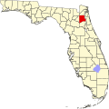
Clay County Florida Incorporated and Unincorporated areas Lakeside Highlighted.svg
Location in Clay County and the state of Florida
Coordinates: 30°8′5″N81°45′57″W / 30.13472°N 81.76583°W / 30.13472; -81.76583 Coordinates: 30°8′5″N81°45′57″W / 30.13472°N 81.76583°W / 30.13472; -81.76583
Country Flag of the United States.svg  United States of America
State Flag of Florida.svg  Florida
County Flag of Clay County, Florida.png Clay
Area
[1]
  Total15.65 sq mi (40.53 km2)
  Land13.45 sq mi (34.84 km2)
  Water2.19 sq mi (5.68 km2)
Elevation
66 ft (20 m)
Population
 (2020)
  Total31,275
  Density2,324.76/sq mi (897.60/km2)
Time zone UTC-5 (Eastern (EST))
  Summer (DST) UTC-4 (EDT)
FIPS code 12-38813 [2]
GNIS feature ID1867166 [3]

Lakeside is an unincorporated area and census-designated place in Clay County, Florida, United States. The population was 30,943 at the 2010 census. [4] It is part of the greater Orange Park area.

Contents

Geography

Lakeside is located in northeastern Clay County at 30°8′5″N81°45′57″W / 30.13472°N 81.76583°W / 30.13472; -81.76583 (30.134840, -81.765767). [5] It is bordered on its northeastern edge by the Town of Orange Park. To the north is the Bellair-Meadowbrook Terrace CDP, and to the southeast, across Doctors Lake, an inlet of the St. Johns River, is Fleming Island. The community of Doctors Inlet is just to the south of Lakeside.

According to the United States Census Bureau, the CDP has a total area of 15.7 square miles (40.7 km2), of which 13.5 square miles (35.0 km2) is land and 2.2 square miles (5.7 km2), or 13.96%, is water. [4]

History

The Yerkes Regional Primate Research Center, one of ten regional centers for primate research, was once located just west of Orange Park in what is now the Lakeside CDP. The center, established in 1930 by psychologist Robert Yerkes and Yale University and the Rockefeller Foundation, was the first laboratory in the United States for the study of non-human primates. Prior to the opening of the facility, Yerkes was engaged in his own research with two great apes, named "Chim" and "Panzee". His findings convinced officials at Yale University, the Rockefeller Foundation and the Carnegie Foundation to sponsor the Florida facility. Initially designed to house about 25 chimpanzees, researchers worked with an estimated 65 chimps (and possibly more) during the lab's 35-year history. This location was home to chimpanzees nurtured as humans such as Gua and Viki and other primates from the estate of Madame Rosalia Abreu in Havana, Cuba. It was home to some of the leading behavioral scientists of the time, some of whom either liked or hated living in the humid South. These researchers studied various aspects of primate behavior, including basic biology, sensory function, reproductive systems, behavioral patterns, physiology and anatomy. Comically, rumors about the place by some Orange Park residents included those of scientists cross-breeding humans with apes. The term "Monkey Farm" has been used by some residents, who may be aware of the location's history, to describe the lab's functions.

The plot of land upon which Yerkes Labs sat was 188 acres (76 ha), about a mile west of Orange Park. The actual research buildings sat on less than an acre, on what is now part of the Foxwood Center plaza (facing Orange Park Medical Center on Kingsley Avenue) in unincorporated land outside the town limits. In 1966, the abandoned buildings and adjacent land were purchased by Developer Marvin Wilhite of Ahpla, Inc., who still lives in Foxwood and built other communities such as Foxridge. He chose the name Ahpla (using a backward arrangement of the letters) after a female chimp named Alpha, who was the first chimp born at the Yerkes Labs on September 11, 1930.

Foxwood Center still has some of the original laboratory buildings that once housed the chimps, the grounds caretaker, and administrative offices. These stand alongside others that have been added, including the Orange Park Chamber of Commerce building. The old caretaker's house is now known as The Granary, an organic food and health store.

In 1956, Emory University took over operation of the Center. In 1965, the center was relocated to the campus of Emory University in Atlanta, Georgia. In 2002, the Center was renamed the Yerkes National Primate Research Center, though officially the "Regional" name still applies.

Demographics

Historical population
CensusPop.Note
1980 10,534
1990 29,137176.6%
2000 30,9276.1%
2010 30,9430.1%
2020 31,2751.1%
source: [6] [4]

As of the census [2] of 2000, there were 30,943 people, 10,753 households, and 8,785 families residing in the CDP. The population density was 2,040.8 inhabitants per square mile (788.0/km2). There were 11,144 housing units at an average density of 735.3 per square mile (283.9/km2). The racial makeup of the CDP was 80.9% White, 10% African American, 0.5% Native American, 3% Asian, 0.1% Pacific Islander, 2.4% from other races, and 3.4% from two or more races. Hispanic or Latino of any race were 8.1% of the population.

There were 10,753 households, out of which 42.1% had children under the age of 18 living with them, 66.6% were married couples living together, 11.5% had a female householder with no husband present, and 18.3% were non-families. 14.1% of all households were made up of individuals, and 4.0% had someone living alone who was 65 years of age or older. The average household size was 2.87 and the average family size was 3.15.

In the CDP, the population was spread out, with 28.4% under the age of 18, 8.7% from 18 to 24, 29.4% from 25 to 44, 25.8% from 45 to 64, and 7.6% who were 65 years of age or older. The median age was 36 years. For every 100 females, there were 95.8 males. For every 100 females age 18 and over, there were 92.9 males.

The median income for a household in the CDP was $52,013, and the median income for a family was $56,254. Males had a median income of $36,787 versus $25,703 for females. The per capita income for the CDP was $20,785. About 3.6% of families and 4.5% of the population were below the poverty line, including 5.5% of those under age 18 and 6.0% of those age 65 or over.

Education

The largest of three campuses of St. Johns River State College, formerly known as St. Johns River Community College, is located in Lakeside on College Drive. The college is home to Thrasher-Horne Center for the arts, a performing arts theater used for various plays and events. [7] The college has a regular student base of 2,221 students but also hosts many dual enrollment students from Clay County high schools. [8]

Related Research Articles

<span class="mw-page-title-main">Alexandria, Alabama</span> Unincorporated community in Alabama, United States

Alexandria is a census-designated place and unincorporated community in Calhoun County, Alabama, United States. At the 2020 census, the population was 4,032. It is included in the Anniston–Oxford, Alabama Metropolitan Statistical Area.

<span class="mw-page-title-main">Lake Hamilton, Arkansas</span> Census-designated place in Arkansas, United States

Lake Hamilton is a census-designated place (CDP) in Garland County, Arkansas, United States. It is part of the Hot Springs Metropolitan Statistical Area. The population was 2,135 at the 2010 census. It is named after Lake Hamilton, one of the area's man-made lakes.

<span class="mw-page-title-main">South Taft, California</span> Census-designated place in California, United States

South Taft is a census-designated place (CDP) in Kern County, California, United States. South Taft is located 0.5 miles (0.8 km) south of Taft, at an elevation of 1,017 feet (310 m). The population was 2,169 at the 2010 census, up from 1,898 at the time of the 2000 census.

<span class="mw-page-title-main">Taft Heights, California</span> Census-designated place in California, United States

Taft Heights is a census-designated place (CDP) in Kern County, California, United States. Taft Heights is located 1 mile (1.6 km) west-southwest of Taft, at an elevation of 1,178 feet (359 m). The population was 1,949 at the 2010 census, up from 1,865 at the 2000 census.

<span class="mw-page-title-main">Lakeside, California</span> Census designated place in California, United States

Lakeside is a census-designated place (CDP) in the East County region of San Diego County, California. The population was 21,152 at the 2020 census, up from 20,648 as of the 2010 census.

<span class="mw-page-title-main">Lake Asbury, Florida</span> Census-designated place in Florida, United States

Lake Asbury is an unincorporated community and census-designated place (CDP) in Clay County, Florida, United States. The population was 8,700 at the 2010 census, which calls it Asbury Lake.

<span class="mw-page-title-main">Bellair-Meadowbrook Terrace, Florida</span> Census-designated place in Florida, United States

Bellair-Meadowbrook Terrace is an unincorporated area and census-designated place (CDP) in Clay County, Florida, United States. The population was 13,343 at the 2010 census.

<span class="mw-page-title-main">Orange Park, Florida</span> Town in the state of Florida, United States

Orange Park is a town in Clay County, Florida, United States. It is a suburb of Jacksonville, in neighboring Duval County. The population was 8,412 at the 2010 census. The name "Orange Park" is additionally applied to a wider area of northern Clay County outside the town limits, covering such communities as Fleming Island, Lakeside, Bellair-Meadowbrook Terrace and Oakleaf Plantation.

<span class="mw-page-title-main">Heathrow, Florida</span> CDP in Florida, United States

Heathrow is a census-designated place and an unincorporated suburban community in Seminole County, Florida, United States. Heathrow is on the I-4 Corridor in Central Florida, 19 miles northeast of Orlando and 38 miles southwest of Daytona Beach. Heathrow comprises a master-planned, private gated residential community of approximately 2,200 homes, and the Heathrow International Business Center, an office park. Heathrow was founded in 1985 by Jeno Paulucci, a food business entrepreneur. The area had been a source of celery used in making his Chun King Foods American Chinese style food. The population was 4,068 at the 2000 census. Heathrow is home to the national headquarters of the American Automobile Association (AAA).

<span class="mw-page-title-main">Evans, Georgia</span> Census-designated place in Georgia, United States

Evans is a census-designated place (CDP) in Columbia County, Georgia, United States. It is a suburb of Augusta and is part of the Augusta metropolitan area. The population was 29,011 at the 2010 census, up from 17,727 at the 2000 census.

<span class="mw-page-title-main">Lake Fenton, Michigan</span> Census-designated place & unincorporated community in Michigan, United States

Lake Fenton is a census-designated place (CDP) in Fenton Charter Township, Genesee County in the U.S. state of Michigan. As of the 2010 census the population was 5,559, up from 4,876 at the 2000 census. The CDP includes the unincorporated communities of Bayport Park and Lakeside.

<span class="mw-page-title-main">Lakeside, Montana</span> Unincorporated community in Montana, United States

Lakeside is an unincorporated area and census-designated place (CDP) in Flathead County, Montana, United States. The population was 2,669 at the 2010 census, up from 1,679 in 2000.

<span class="mw-page-title-main">Somers, Montana</span> Unincorporated community in Montana, United States

Somers is an unincorporated community and census-designated place (CDP) in Flathead County, Montana, United States. The population was 1,109 at the 2010 census, up from 556 in 2000.

Lorenz Park is a census-designated place (CDP) in Columbia County, New York, United States. The population was 2,053 at the 2010 census.

<span class="mw-page-title-main">Orange Lake, New York</span> CDP in New York, United States

Orange Lake is a hamlet in Orange County, New York, United States. The population was 9,770 at the 2020 census. It is part of the Newburgh–Middletown, NY Metropolitan Statistical Area as well as the larger New York–Newark–Bridgeport, NY-NJ-CT-PA Combined Statistical Area.

<span class="mw-page-title-main">Orient, New York</span> Hamlet and census-designated place in New York, United States

Orient is a hamlet and census-designated place (CDP) in Suffolk County, Long Island, New York, United States. The CDP's population was 743 at the 2010 census.

<span class="mw-page-title-main">Lakeside, Virginia</span> Census-designated area in Virginia

Lakeside is a census-designated place (CDP) in Henrico County, Virginia, United States. It is an inner suburb of Richmond, Virginia. The population was 11,849 at the 2010 census.

<span class="mw-page-title-main">Williams Bay, Wisconsin</span> Village in Wisconsin, United States

Williams Bay is a village in Walworth County, Wisconsin, United States. It is one of three municipalities on Geneva Lake. The population was 2,953 at the 2020 census.

<span class="mw-page-title-main">Brewster (CDP), Massachusetts</span> Census-designated place in Massachusetts, United States

Brewster is a census-designated place (CDP) in the town of Brewster in Barnstable County, Massachusetts, United States. The population was 2,000 at the 2010 census, out of 9,820 in the town of Brewster as a whole.

<span class="mw-page-title-main">Covington Township, Lackawanna County, Pennsylvania</span> Place in Pennsylvania, United States

Covington Township is a township in Lackawanna County, Pennsylvania, United States. The population was 2,206 as of the 2020 Census.

References

  1. "2020 U.S. Gazetteer Files". United States Census Bureau. Retrieved October 31, 2021.
  2. 1 2 "U.S. Census website". United States Census Bureau . Retrieved 2008-01-31.
  3. "US Board on Geographic Names". United States Geological Survey. 2007-10-25. Retrieved 2008-01-31.
  4. 1 2 3 "Geographic Identifiers: 2010 Demographic Profile Data (G001): Lakeside CDP, Florida". U.S. Census Bureau, American Factfinder. Archived from the original on February 12, 2020. Retrieved June 27, 2014.
  5. "US Gazetteer files: 2010, 2000, and 1990". United States Census Bureau. 2011-02-12. Retrieved 2011-04-23.
  6. "CENSUS OF POPULATION AND HOUSING (1790-2000)". U.S. Census Bureau . Retrieved 2010-07-31.
  7. "Jacksonville Events & Convention Center | Concerts & Broadway Shows". Thrasher-Horne Center.
  8. "Archived copy" (PDF). Archived from the original (PDF) on 2013-01-24. Retrieved 2014-06-27.{{cite web}}: CS1 maint: archived copy as title (link)