St. Augustine Beach, Florida | |
---|---|
City of St. Augustine Beach | |
![]() St. Augustine Beach City Hall | |
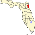
![]() Location in St. Johns County and the state of Florida | |
Coordinates: 29°50′37″N81°16′20″W / 29.84361°N 81.27222°W | |
Country | ![]() |
State | ![]() |
County | St. Johns |
Incorporated | 1959 |
Government | |
• Type | Commission–Manager |
• Mayor | Donald Samora |
• Vice Mayor | Dylan Rumrell |
• Commissioners | Beth Sweeny, Undine C. George, and Virginia Morgan |
• City Manager | Max Royle |
• City Clerk | Dariana Fitzgerald |
Area | |
• Total | 2.17 sq mi (5.61 km2) |
• Land | 2.12 sq mi (5.50 km2) |
• Water | 0.04 sq mi (0.11 km2) |
Elevation | 7 ft (2 m) |
Population (2020) | |
• Total | 6,803 |
• Density | 3,202.92/sq mi (1,236.59/km2) |
Time zone | UTC-5 (Eastern (EST)) |
• Summer (DST) | UTC-4 (EDT) |
ZIP code | 32080 |
Area code(s) | 904, 324 |
FIPS code | 12-62525 [2] |
GNIS feature ID | 0308102 [3] |
Website | http://www.staugbch.com |
St. Augustine Beach is a city in St. Johns County, Florida, United States. The population was 6,803 at the 2020 US census, up from 6,176 at the 2010 census. It is part of the Jacksonville, Florida Metropolitan Statistical Area.
St. Augustine Beach is located at 29°50′37″N81°16′20″W / 29.84361°N 81.27222°W (29.843657, –81.272206). [4]
According to the United States Census Bureau, the city has a total area of 1.9 square miles (5.0 km2), all land.
The boundaries of St. Augustine Beach are the Atlantic Ocean, the west right-of-way of Florida State Road A1A, the north right-of-way of Pope Road, and Sandpiper Village subdivision to the south.
Census | Pop. | Note | %± |
---|---|---|---|
1960 | 396 | — | |
1970 | 632 | 59.6% | |
1980 | 1,289 | 104.0% | |
1990 | 3,657 | 183.7% | |
2000 | 4,683 | 28.1% | |
2010 | 6,176 | 31.9% | |
2020 | 6,803 | 10.2% | |
U.S. Decennial Census [5] |
Race | Pop 2010 [6] | Pop 2020 [7] | % 2010 | % 2020 |
---|---|---|---|---|
White (NH) | 5,734 | 6,028 | 92.84% | 88.61% |
Black or African American (NH) | 43 | 33 | 0.70% | 0.49% |
Native American or Alaska Native (NH) | 15 | 6 | 0.24% | 0.09% |
Asian (NH) | 72 | 78 | 1.17% | 1.15% |
Pacific Islander or Native Hawaiian (NH) | 2 | 4 | 0.03% | 0.06% |
Some other race (NH) | 7 | 47 | 0.11% | 0.69% |
Two or more races/Multiracial (NH) | 71 | 233 | 1.15% | 3.42% |
Hispanic or Latino (any race) | 232 | 374 | 3.76% | 5.50% |
Total | 6,176 | 6,803 | ||
As of the 2020 United States census, there were 6,803 people, 2,851 households, and 1,762 families residing in the city. [8]
As of the 2010 United States census, there were 6,176 people, 5,494 households, and 2,546 families residing in the city. [9]
At the 2000 census [2] there were 4,683 people in 2,213 households, including 1,263 families, in the city. The population density was 2,413.1 inhabitants per square mile (931.7/km2). There were 3,140 housing units at an average density of 1,618.0 units per square mile (624.7 units/km2). The racial makeup of the city is 96.80% White, 0.32% African American, 0.41% Native American, 1.15% Asian, 0.02% Pacific Islander, 0.43% from other races, and 0.88% from two or more races. 2.75% of the population are Hispanic or Latino of any race.
Of the 2,213 households in 2000, 18.8% had children under the age of 18 living with them, 46.6% were married couples living together, 7.8% had a female householder with no husband present, and 42.9% were non-families. 28.8% of households were one person and 10.3% were one person aged 65 or older. The average household size was 2.12 and the average family size was 2.57.
In 2000, the age distribution was 15.4% under the age of 18, 11.0% from 18 to 24, 26.2% from 25 to 44, 27.5% from 45 to 64, and 19.9% 65 or older. The median age was 43 years. For every 100 females, there were 95.0 males. For every 100 females age 18 and over, there were 92.8 males.
In 2000, the median household income was $59,484. Males had a median income of $34,883 versus $26,250 for females. The per capita income for the city was $57,905. About 1.4% of families and 2.7% of the population were below the poverty line, including 2.0% of those under age 18 and 3.3% of those age 65 or over.
St. Augustine Beach is organized with a commission-manager form of government; voters elect a City Commission which consists of five members who serve four-year, staggered terms. The five members are elected equally as Commissioners then the Commissioners vote to appoint a member as Mayor and Vice Mayor.
The City Commission meets monthly on the first Monday of the month excluding holidays. The Commission appoints a City Manager, who carries out the will of the commission and handles day-to-day business.
Position | Name | Term Expiration |
---|---|---|
Mayor | Dylan Rumrell | 2028 |
Vice Mayor | Beth Sweeny | 2028 |
Commissioner | Undine C. George | 2026 |
Commissioner | Donald Samora | 2026 |
Commissioner | Virginia Morgan | 2026 |
City Manager | Max Royle | Appointed |
Bus service is operated by the Sunshine Bus Company. Though based in the city, [11] it also serves neighboring St. Augustine including the historic districts, and the rest of the county. Buses operate mainly between shopping centers across town, but a few go to Hastings and Jacksonville, where one can connect to JTA for additional service across Jacksonville.
It is in the St. Johns County School District. [12]
The zoned elementary schools include: [13] R. B. Hunt Elementary School, which serves almost all of the city; [14] and W. D. Hartley Elementary School, which serves a small portion. [15]
The zoned middle schools include: [16] Sebastian Middle School, which serves almost all of the city; [17] and Gamble Rogers Middle School, which serves a small portion. [18]
The zoned high schools include: [19] St. Augustine High School, which serves almost all of the city; [20] and Pedro Menendez High School, which serves a small portion. [21]
St. Johns County Public Library maintains the Anastasia Island Beach Branch. [22]
124 Seagrove Main St St. Augustine Beach, FL 32080