Lake Asbury, Florida Asbury Lake | |
---|---|
Coordinates: 30°3′10″N81°48′59″W / 30.05278°N 81.81639°W | |
Country | United States |
State | Florida |
County | Clay |
Area | |
• Total | 17.23 sq mi (44.63 km2) |
• Land | 16.96 sq mi (43.93 km2) |
• Water | 0.27 sq mi (0.70 km2) |
Elevation | 33 ft (10 m) |
Population (2020) | |
• Total | 11,036 |
• Density | 650.63/sq mi (251.21/km2) |
Time zone | UTC-5 (Eastern (EST)) |
• Summer (DST) | UTC-4 (EDT) |
FIPS code | 12-02187 [2] |
GNIS feature ID | 1867111 [3] |
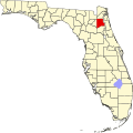
Lake Asbury is an unincorporated community and census-designated place (CDP) in Clay County, Florida, United States. It is referred to as the Asbury Lake CDP by the U.S. Census Bureau. [4] The population at the 2020 census was 11,036, up from 8,700 at the 2010 census. [5] It is part of the Jacksonville, Florida Metropolitan Statistical Area.
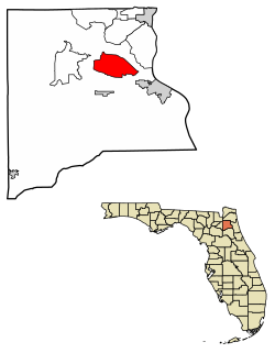
Lake Asbury is located north of the center of Clay County at 30°03′10″N81°48′59″W / 30.052914°N 81.816296°W . [6] The community surrounds a small reservoir of the same name, though it has also recently expanded eastward. It is bordered on the north by Black Creek, a tributary of the St. Johns River. The community is 13 miles (21 km) southwest of Orange Park and 30 miles (48 km) southwest of downtown Jacksonville.
According to the United States Census Bureau, the CDP has a total area of 17.3 square miles (44.8 km2), of which 17.0 square miles (44.1 km2) is land and 0.27 square miles (0.7 km2), or 1.56%, is water. [4]
Census | Pop. | Note | %± |
---|---|---|---|
1990 | 2,072 | — | |
2000 | 2,228 | 7.5% | |
2010 | 8,700 | 290.5% | |
2020 | 11,036 | 26.9% | |
U.S. Decennial Census [7] |
As of the census [2] of 2010, there were 8,700 people, 2,848 households, and 2,450 families residing in the CDP, a 290% increase from 2000. The population density was 2,417.6 inhabitants per square mile (933.4/km2). There were 3,048 housing units at an average density of 846.6 units per square mile (326.9 units/km2). The racial makeup of the CDP was 88.8% White, 5.7% African American, 0.5% Native American, 1.3% Asian, 1.1% from other races, and 2.4% from two or more races. Hispanic or Latino of any race were 7.0% of the population.
There were 799 households, out of which 30.7% had children under the age of 18 living with them, 80.0% were married couples living together, 5.4% had a female householder with no husband present, and 12.6% were non-families. 10.1% of all households were made up of individuals, and 5.1% had someone living alone who was 65 years of age or older. The average household size was 2.79 and the average family size was 2.98.
In the CDP, the population was spread out, with 22.5% under the age of 18, 5.9% from 18 to 24, 23.9% from 25 to 44, 35.5% from 45 to 64, and 12.2% who were 65 years of age or older. The median age was 44 years. For every 100 females, there were 101.8 males. For every 100 females age 18 and over, there were 98.3 males.
The median income for a household in the CDP was $65,476, and the median income for a family was $70,278. Males had a median income of $47,000 versus $30,167 for females. The per capita income for the CDP was $26,398. About 4.2% of families and 3.8% of the population were below the poverty line, including 2.2% of those under age 18 and 4.9% of those age 65 or over.
Bellair-Meadowbrook Terrace is an unincorporated area and census-designated place (CDP) in Clay County, Florida, United States. The population was 14,482 at the 2020 census, up from 13,343 at the 2010 census. It is part of the Jacksonville, Florida Metropolitan Statistical Area.
Lely is a census-designated place (CDP) in Collier County, Florida, United States. The population was 3,694 at the 2020 census, up from 3,451 at the 2010 census. It is part of the Naples–Marco Island Metropolitan Statistical Area.
Lake Lindsey is an unincorporated community and census-designated place (CDP) in Hernando County, Florida, United States. The population was 71 at the 2010 census.
Spring Lake is an unincorporated community and census-designated place (CDP) in Hernando County, Florida, United States. The population was 458 at the 2010 census, up from 327 at the 2000 census.
Sylvan Shores is an unincorporated community and former census-designated place (CDP) in Highlands County, Florida, United States, located immediately northeast of the town of Lake Placid. As of the 2000 census, the CDP population was 2,424.
University is an unincorporated census-designated place in Hillsborough County, Florida, United States. The population was 41,163 at the 2010 census, up from 30,736 at the 2000 census. The University of South Florida is located just southeast of the community, within the Tampa city limits. The community is also known as "University West", mainly due to its location in relation to the university. The community is often notoriously referred to by locals as "Suitcase City" due to the high rate of transients.
Ferndale is a census-designated place (CDP) in Lake County, Florida, United States. The population was 472 at the 2010 census, up from 233 at the 2000 census. It is part of the Orlando–Kissimmee Metropolitan Statistical Area.
Lake Kathryn is a census-designated place (CDP) in Lake County, Florida, United States. The population was 920 at the 2010 census. The area is also known as Lake Kathryn Heights. It is part of the Orlando–Kissimmee Metropolitan Statistical Area.
Lisbon is an unincorporated community and census-designated place (CDP) in Lake County, Florida, United States. The population was 260 at the 2000 census. It is part of the Orlando–Kissimmee Metropolitan Statistical Area.
Pine Lakes is an unincorporated community and census-designated place (CDP) in Lake County, Florida, United States. The population was 862 at the 2010 census, up from 755 at the 2000 census. It is part of the Orlando–Kissimmee Metropolitan Statistical Area.
Silver Lake is a census-designated place (CDP) in Lake County, Florida, United States. The population was 1,879 at the 2010 census. It is part of the Orlando–Kissimmee Metropolitan Statistical Area.
Sorrento is an unincorporated community and census-designated place in Lake County, Florida, United States. The population was 861 at the 2010 census, up from 765 at the 2000 census. It is part of the Orlando–Kissimmee Metropolitan Statistical Area.
Tice is an unincorporated community and census-designated place (CDP) in Lee County, Florida, United States. As of the 2020 census, the CDP population was 4,853. It is part of the Cape Coral-Fort Myers, Florida Metropolitan Statistical Area.
Whiskey Creek is a census-designated place (CDP) in Lee County, Florida, United States. The population was 4,842 at the 2020 census, up from 4,655 at the 2010 census. It is part of the Cape Coral-Fort Myers, Florida Metropolitan Statistical Area.
Kendall West is a census-designated place and unincorporated community in Miami-Dade County, Florida, west of the Florida Turnpike. It is located in the Miami metropolitan area of South Florida. The population was 36,536 at the 2020 census.
Three Lakes is a census-designated place (CDP) and planned community in Miami-Dade County, Florida, United States. It is part of the Miami metropolitan area of South Florida. The population was 16,540 at the 2020 census, up from 15,047 in 2010.
Holden Lakes is a census-designated place and unincorporated area in Orange County, Florida, United States. The population was 3,679 at the 2010 census. The ZIP code serving the CDP is 32839. It is part of the Orlando–Kissimmee Metropolitan Statistical Area.
East Palatka is a census-designated place (CDP) in Putnam County, Florida, United States. It is located on the east side of the City of Palatka at the intersection of U.S. Route 17/State Road 20/State Road 100 and the southwestern terminus of State Road 207. The population was 1,573 at the 2020 census, down from 1,654 at the 2010 census. It is part of the Palatka, Florida Micropolitan Statistical Area.
Carrollwood is a census-designated place (CDP) in northwestern Hillsborough County, Florida, United States. The census area includes the unincorporated communities of Carrollwood and Carrollwood Village. For the 2000 census the area was enumerated under the name "Greater Carrollwood". A similar area was listed as "Lake Carroll" in 1970 and 1980; for the 1990 census it was split into the smaller Carrollwood and Carrollwood Village CDPs. The population was 34,352 at the 2020 census.
Lake Katrine is a hamlet in Ulster County, New York, United States. The population was 2,522 at the 2020 census.