Woodbine, Georgia

Last updated

Woodbine, Georgia
WoodbineGAMO.png
Top, left to right: Camden County Courthouse, Old Camden County Courthouse, Satilla River, St. Mark's Episcopal Church, Woodbine Historic District
WoodbineCityLogo.png
Motto(s): 
"Cherish Yesterday, Embrace Today, Prepare for Tomorrow" [1]
Camden County Georgia Incorporated and Unincorporated areas Woodbine Highlighted.svg
Location in Camden County and the state of Georgia
Coordinates: 30°57′43″N81°43′12″W / 30.96194°N 81.72000°W / 30.96194; -81.72000
Country United States
State Georgia
County Camden
Area
[2]
  Total2.61 sq mi (6.76 km2)
  Land2.54 sq mi (6.59 km2)
  Water0.07 sq mi (0.17 km2)
Elevation
13 ft (4 m)
Population
 (2020)
  Total1,062
  Density417.45/sq mi (161.20/km2)
Time zone UTC-5 (Eastern (EST))
  Summer (DST) UTC-4 (EDT)
ZIP code
31569
Area code 912
FIPS code 13-83868 [3]
GNIS feature ID0325526 [4]
Website woodbinegeorgia.net

Woodbine is a city in and the county seat of Camden County, Georgia, United States, an original county established when the state constitution was adopted in 1777. [5] [6] The population was 1,062 in 2020.

Contents

The East Coast Greenway, a 3,000 mile long system of trails connecting Maine to Florida, runs along the Woodbine Riverwalk. Spaceport Camden is being developed adjacent to the city.

History

Records in 1765 show that John Brown, John McGillvary, William Molyneaux and William Trowin petitioned English authorities for 1,400 acres (570 ha) south of the Satilla River. They were granted the land named Pile's Bluff, which historians believe to be near Woodbine. [5]

A tract of land was granted to Anton Cunning by the state in 1808. It became known as the Woodbine Plantation. Luke John Bailey purchased it in 1835 and held it through the Civil War, during which the house was burned by Union troops. James King Bedell acquired the property, constructed a new house, and restored the plantation. The railroad entered Camden County in 1893, and Bedell sold a right-of-way across his land, but required that the first rail community be named "Woodbine". [5]

Woodbine was incorporated as a town on August 13, 1908, [7] and the word is the common English name for the honeysuckle, Lonicera. [7] [8] The town grew more after the Atlantic Coastal Highway was constructed during 1927 and the county seat relocated there the following year. Woodbine re-incorporated as a city in 1953. [5]

On the morning of February 3, 1971 the Thiokol Chemical Corporation, a factory that made flares for soldiers fighting in Vietnam, exploded. Twenty-eight employees of the factory, predominantly Black women, were killed after a flame in a small building, according to court records, triggered a massive explosion. The blast blew pieces of the building almost a mile away, left more than 50 other people injured. [9]

Geography

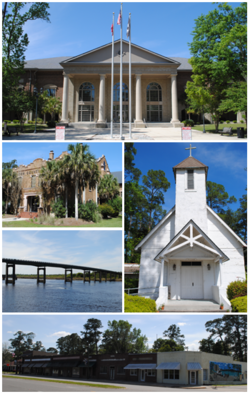
The city is situated near the center of the county, which is located in the southeast corner of the state near the Florida border. It is located on the south bank of the Satilla River near the head of its tidal extent. U.S. Route 17 (Ocean Highway) passes through the center of the city, leading northeast 29 miles (47 km) to Brunswick and south 11 miles (18 km) to Kingsland. The city has extended its borders 2 miles (3 km) east along 10th Street to reach Interstate 95 at its Exit 14.

Woodbine is located at 30°57′43″N81°43′12″W / 30.96194°N 81.72000°W / 30.96194; -81.72000 (30.961869, -81.720017). [10]

According to the United States Census Bureau, the city has a total area of 2.6 square miles (6.7 km2), of which 2.5 square miles (6.5 km2) is land and 0.08 square miles (0.2 km2), or 2.37%, is water. [11]

Climate

Climate data for Woodbine, Georgia (1991–2020 normals, extremes 1998–present)
MonthJanFebMarAprMayJunJulAugSepOctNovDecYear
Record high °F (°C)84
(29)
86
(30)
91
(33)
94
(34)
98
(37)
100
(38)
102
(39)
102
(39)
96
(36)
94
(34)
89
(32)
85
(29)
102
(39)
Average high °F (°C)62.6
(17.0)
65.9
(18.8)
71.9
(22.2)
77.7
(25.4)
83.7
(28.7)
88.2
(31.2)
90.9
(32.7)
89.2
(31.8)
85.3
(29.6)
78.6
(25.9)
70.4
(21.3)
64.5
(18.1)
77.4
(25.2)
Daily mean °F (°C)50.3
(10.2)
53.7
(12.1)
59.3
(15.2)
65.2
(18.4)
72.3
(22.4)
78.2
(25.7)
80.9
(27.2)
80.2
(26.8)
76.4
(24.7)
68.0
(20.0)
59.0
(15.0)
53.0
(11.7)
66.4
(19.1)
Average low °F (°C)38.0
(3.3)
41.5
(5.3)
46.7
(8.2)
52.7
(11.5)
61.0
(16.1)
68.2
(20.1)
70.9
(21.6)
71.1
(21.7)
67.4
(19.7)
57.3
(14.1)
47.6
(8.7)
41.5
(5.3)
55.3
(12.9)
Record low °F (°C)10
(−12)
10
(−12)
21
(−6)
22
(−6)
41
(5)
51
(11)
58
(14)
57
(14)
50
(10)
30
(−1)
24
(−4)
19
(−7)
10
(−12)
Average precipitation inches (mm)3.61
(92)
3.67
(93)
3.58
(91)
3.52
(89)
3.92
(100)
6.20
(157)
5.51
(140)
7.76
(197)
6.70
(170)
4.74
(120)
2.33
(59)
3.04
(77)
54.58
(1,386)
Average precipitation days (≥ 0.01 in)7.37.96.96.06.011.511.914.111.06.85.36.9101.6
Source: NOAA [12] [13]

Demographics

Historical population
CensusPop.Note
1910 155
1920 17211.0%
1930 33594.8%
1940 37311.3%
1950 750101.1%
1960 84512.7%
1970 1,00218.6%
1980 910−9.2%
1990 1,21233.2%
2000 1,2180.5%
2010 1,41215.9%
2020 1,062−24.8%
U.S. Decennial Census [14]
Woodbine racial composition as of 2020 [15]
RaceNum.Perc.
White (non-Hispanic)60657.06%
Black or African American (non-Hispanic)38536.25%
Native American 40.38%
Asian 70.66%
Pacific Islander 40.38%
Other/Mixed 444.14%
Hispanic or Latino 121.13%

As of the 2020 United States census, there were 1,062 people, 467 households, and 316 families residing in the city.

See also

Related Research Articles

<span class="mw-page-title-main">Wayne County, Georgia</span> County in Georgia, United States

Wayne County is a county located in the southeastern part of the U.S. state of Georgia. As of the 2020 census, the population was 30,144. The county seat is Jesup.

<span class="mw-page-title-main">Ware County, Georgia</span> County in Georgia, United States

Ware County is a county located in the southeastern part of the U.S. state of Georgia. As of the 2020 census, the population was 36,251. The county seat and only incorporated place is Waycross.

<span class="mw-page-title-main">Pierce County, Georgia</span> County in Georgia, United States

Pierce County is a county located in the southeastern part of the U.S. state of Georgia. As of the 2020 census, the population was 19,716. The county seat is Blackshear.

<span class="mw-page-title-main">Jeff Davis County, Georgia</span> County in Georgia, United States

Jeff Davis County is a county located in the southeastern part of the U.S. state of Georgia. As of the 2020 census, the population was 14,779. The county seat is Hazlehurst. The county was created on August 18, 1905, and named for Jefferson Davis, the only Confederate president.

<span class="mw-page-title-main">Glynn County, Georgia</span> County in Georgia, United States

Glynn County is located in the southeastern part of the U.S. state of Georgia. As of the 2020 census, the population was 84,499. The county seat is Brunswick. Glynn County is part of the Brunswick, Georgia Metropolitan Statistical Area.

<span class="mw-page-title-main">Coffee County, Georgia</span> County in Georgia, United States

Coffee County is a county located in the southeastern part of the U.S. state of Georgia. As of the 2020 census, the population was 43,092, up from 42,356 at the 2010 census. The county seat is Douglas.

<span class="mw-page-title-main">Charlton County, Georgia</span> County in Georgia, United States

Charlton County is the southernmost county of the U.S. state of Georgia, located in the southeastern part of the state. As of the 2020 census, the population was 12,518. The county seat is Folkston.

<span class="mw-page-title-main">Camden County, Georgia</span> County in Georgia, United States

Camden County is a county located in the southeastern corner of the U.S. state of Georgia. According to the 2020 census, its population was 54,768. Its county seat is Woodbine, and the largest city is St. Marys. It is one of the original counties of Georgia, created February 5, 1777. It is the 11th-largest county in the state of Georgia by area, and the 41st-largest by population.

<span class="mw-page-title-main">Brantley County, Georgia</span> County in Georgia, United States

Brantley County is a county located in the southeastern part of the U.S. state of Georgia. As of the 2020 census, the population was 18,021. The county seat is Nahunta. Brantley County is part of the Brunswick, Georgia metropolitan statistical area.

<span class="mw-page-title-main">Bacon County, Georgia</span> County in Georgia, United States

Bacon County is a county located in the southeastern part of the U.S. state of Georgia. As of the 2020 census, the population was 11,140. The county seat is Alma.

<span class="mw-page-title-main">Atkinson County, Georgia</span> County in Georgia, United States

Atkinson County is a county located in the southeastern portion of the U.S. state of Georgia. As of the 2020 census, the population was 8,286. The county seat is Pearson. The county was formed in 1917 from parts of Coffee and Clinch counties. It is named for William Yates Atkinson, Democratic governor of Georgia from 1894 to 1898. In 2003 it had the highest illiteracy rate of any U.S. county at 36%.

<span class="mw-page-title-main">Appling County, Georgia</span> County in Georgia, United States

Appling County is a county located in the southeastern part of the U.S. state of Georgia. As of the 2020 census, the population was 18,444. The county seat is Baxley.

<span class="mw-page-title-main">Kings Bay Base, Georgia</span> Census-designated place in Georgia, United States

Kings Bay Base is a census-designated place (CDP) in Camden County, Georgia, United States; it is home to the Kings Bay Naval Submarine Base. The population was 1,777 at the 2010 census, and 2,329 in 2020.

<span class="mw-page-title-main">Kingsland, Georgia</span> City in Georgia, United States

Kingsland is a city in Camden County, Georgia, United States. The population was 18,337 at the 2020 census.

<span class="mw-page-title-main">St. Marys, Georgia</span> City in Georgia, United States of America

St. Marys is a city in Camden County, Georgia, United States, located on the southern border of Camden County on the St. Marys River in the state's Low Country. The Florida border is just to the south across the river, Cumberland Island National Seashore is to the northeast, and Kingsland, Georgia, is to the west. Jacksonville, Florida, is 38 miles south, and Savannah, Georgia, is 110 miles north.

<span class="mw-page-title-main">Douglas, Georgia</span> City in Georgia, United States

Douglas is a city in Coffee County, Georgia, United States. As of the 2020 census, the city had a population of 11,722. Douglas is the county seat of Coffee County and the core city of the Douglas, Georgia Micropolitan Statistical Area, which had a population of 50,731 as of the 2010 census.

<span class="mw-page-title-main">Waycross, Georgia</span> City in Georgia, USA

Waycross is the county seat of, and only incorporated city in, Ware County in the U.S. state of Georgia. The population was 14,725 at the 2010 Census and dropped to 13,942 in the 2020 census.

<span class="mw-page-title-main">Woodbine, Kansas</span> City in Dickinson County, Kansas

Woodbine is a city in Dickinson County, Kansas, United States. As of the 2020 census, the population of the city was 157.

<span class="mw-page-title-main">Camden, Tennessee</span> City in Tennessee, United States

Camden is a city in Benton County, Tennessee. The population was 3,674 at the 2020 census. It is the county seat of Benton County.

<span class="mw-page-title-main">Satilla River</span> River in the state of Georgia, United States of America

The Satilla River rises in Ben Hill County, Georgia, United States, near the town of Fitzgerald, and flows in a mostly easterly direction to the Atlantic Ocean. Along its approximately 235-mile (378 km) course are the cities of Waycross, Waynesville, and Woodbine. The Satilla drains almost 4,000 square miles (10,000 km2) of land, all of it in the coastal plain of southeastern Georgia. It has white sandbars and is the largest blackwater river situated entirely within Georgia. The Satilla enters the Atlantic Ocean about 10 miles (16 km) south of Brunswick, at the 31st parallel north. Satilla River Marsh Island The river derives its name from a Spanish officer named Saint Illa, and over time the name was corrupted to form the word Satilla. French explorer Jean Ribault named the river the Somme when he encountered it in 1562. The river was later given the name Aisne by Jacques le Moyne.

References

  1. "City of Woodbine Georgia Website". City of Woodbine Georgia Website. Retrieved September 6, 2012.
  2. "2020 U.S. Gazetteer Files". United States Census Bureau. Retrieved December 18, 2021.
  3. "U.S. Census website". United States Census Bureau . Retrieved January 31, 2008.
  4. "US Board on Geographic Names". United States Geological Survey. October 25, 2007. Retrieved January 31, 2008.
  5. 1 2 3 4 "Woodbine History". City of Woodbine, Georgia. Archived from the original on March 9, 2015. Retrieved July 22, 2013.
  6. "Woodbine". Georgia Gov. Retrieved September 6, 2012.
  7. 1 2 "Woodbine". Georgia Department of Community Affairs. Retrieved September 6, 2012.
  8. "Profile for Woodbine, Georgia, GA". ePodunk. Retrieved September 6, 2012.
  9. "Reclaiming History: Museum documents deadly explosion that devastated a Black community in Georgia". Southern Poverty Law Center. Retrieved July 10, 2022.
  10. "US Gazetteer files: 2010, 2000, and 1990". United States Census Bureau. February 12, 2011. Retrieved April 23, 2011.
  11. "Geographic Identifiers: 2010 Demographic Profile Data (G001): Woodbine city, Georgia". U.S. Census Bureau, American Factfinder. Archived from the original on February 12, 2020. Retrieved July 17, 2014.
  12. "NowData – NOAA Online Weather Data". National Oceanic and Atmospheric Administration. Retrieved May 24, 2021.
  13. "Station: Woodbine, GA". U.S. Climate Normals 2020: U.S. Monthly Climate Normals (1991-2020). National Oceanic and Atmospheric Administration. Retrieved May 24, 2021.
  14. "Census of Population and Housing". Census.gov. Retrieved June 4, 2015.
  15. "Explore Census Data". data.census.gov. Retrieved December 18, 2021.