Douglas was chartered as a town in 1895 and as a city in 1897. In 1895, the railroad came to Douglas and the community began to boom.[8] In 1909, the Georgia and Florida Railway located its offices in Douglas.
The Eleventh District Agricultural & Mechanical School was established in Douglas in 1906. In 1927, South Georgia College was founded as Georgia's first state-supported junior college.
During the 1920s and 1930s, Douglas was one of the major tobacco markets in the state. Much of this history is depicted in the Heritage Station Museum, located in the former Georgia and Florida Railway train station on Ward Street in downtown Douglas.
Douglas has two areas listed on the National Register of Historic Places: the downtown and Gaskin Avenue historic districts. They were added to the list in 1989.[9]
In late September 2024, Douglas was in the direct path of Hurricane Helene, which resulted in widespread damage and power outages. A wind gust of 80kn (92mph) was recorded in Douglas during the storm, with 80-85% of homes in Coffee County suffering damage.[13][14]
According to the United States Census Bureau, Douglas has a total area of 14.0 square miles (36.2km2), of which 13.4 square miles (34.7km2) is land and 0.58 square miles (1.5km2), or 4.08%, is water.[16] Major water bodies include Twenty Mile Creek, the Seventeen Mile River (a tributary of the Satilla River), and Hilliard's Pond, which was once the ski show park "Holiday Beach".
Climate
Climate data for Douglas, Georgia, 1991–2020 normals, extremes 1902–2015
As of the 2020 United States census, there were 11,722 people, 4,339 households, and 2,610 families residing in the city.
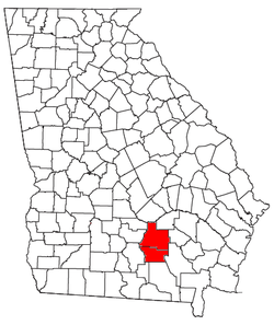
Douglas micropolitan statistical area
Location of the Douglas Micropolitan Statistical Area in Georgia
Douglas is the principal city of the Douglas micropolitan statistical area, a micropolitan area that covers Atkinson and Coffee counties[21] and had a combined population of 50,731 at the 2010 census.[5]
The Electric Department, locally owned and a member of the Municipal Electric Authority of Georgia, services Douglas with power.[22]
The Natural Gas Department, member of both Georgia & American Public Gas Association and the Municipal Gas Authority of Georgia, provides gas to the area.[23]
Water and sewer service is conducted by the city's Water Department.[24]
The Public Works Department handles yard clippings, junk items, and animal control for the city.[25]
Farming plays a large role in the area's economy. Major agricultural products from the town and surrounding county include peanuts, corn, tobacco, and cotton. Chicken is also a major part of the economy.[26]
Tourism
Douglas is home to Heritage Station Museum, which displays artifacts of the city's history. The World War II Flight Training Museum (the old 63rd Army Air Forces Contract Pilot School), Broxton is home to the Broxton Rocks, and the Ashley-Slater House are also popular tourist attractions in the area.[citation needed] All three were recently[when?] named among "Georgia's Hidden Treasures" in a segment on WSB-TV.[citation needed]
Douglas has ten public parks. There are four golf courses in and around the city.
Nearby, the 1,490 acres (6.0km2)General Coffee State Park draws more than 100,000 visitors a year and is the most popular tourist attraction in the area.[citation needed]
The Douglas-Coffee County area is served by the Coffee County Board of Education. The Coffee County School District holds pre-school to grade twelve, and consists of eight elementary schools, a middle school, three high schools, and an alternative education center.[27] The district has 438 full-time teachers and over 8,000 students.[28]
This page is based on this Wikipedia article Text is available under the CC BY-SA 4.0 license; additional terms may apply. Images, videos and audio are available under their respective licenses.